

The Portland Parks and Recreation bureau has a new survey and online open house for their Bridge Over Columbia Blvd project.
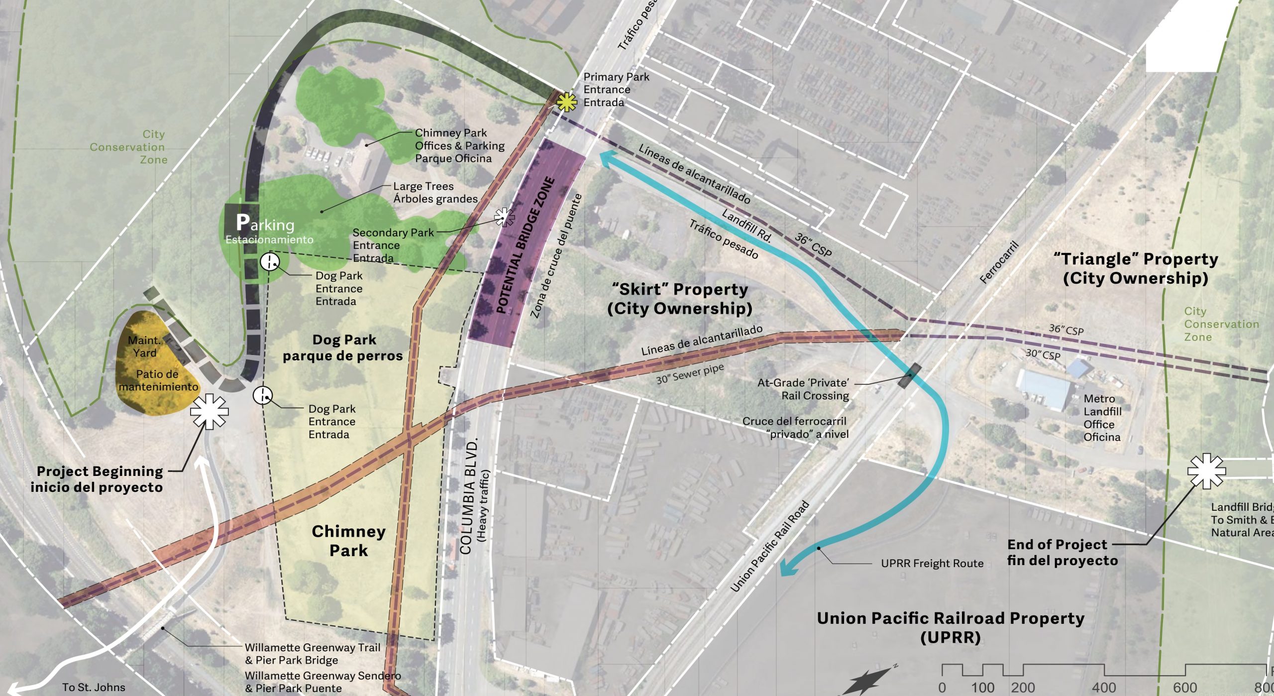
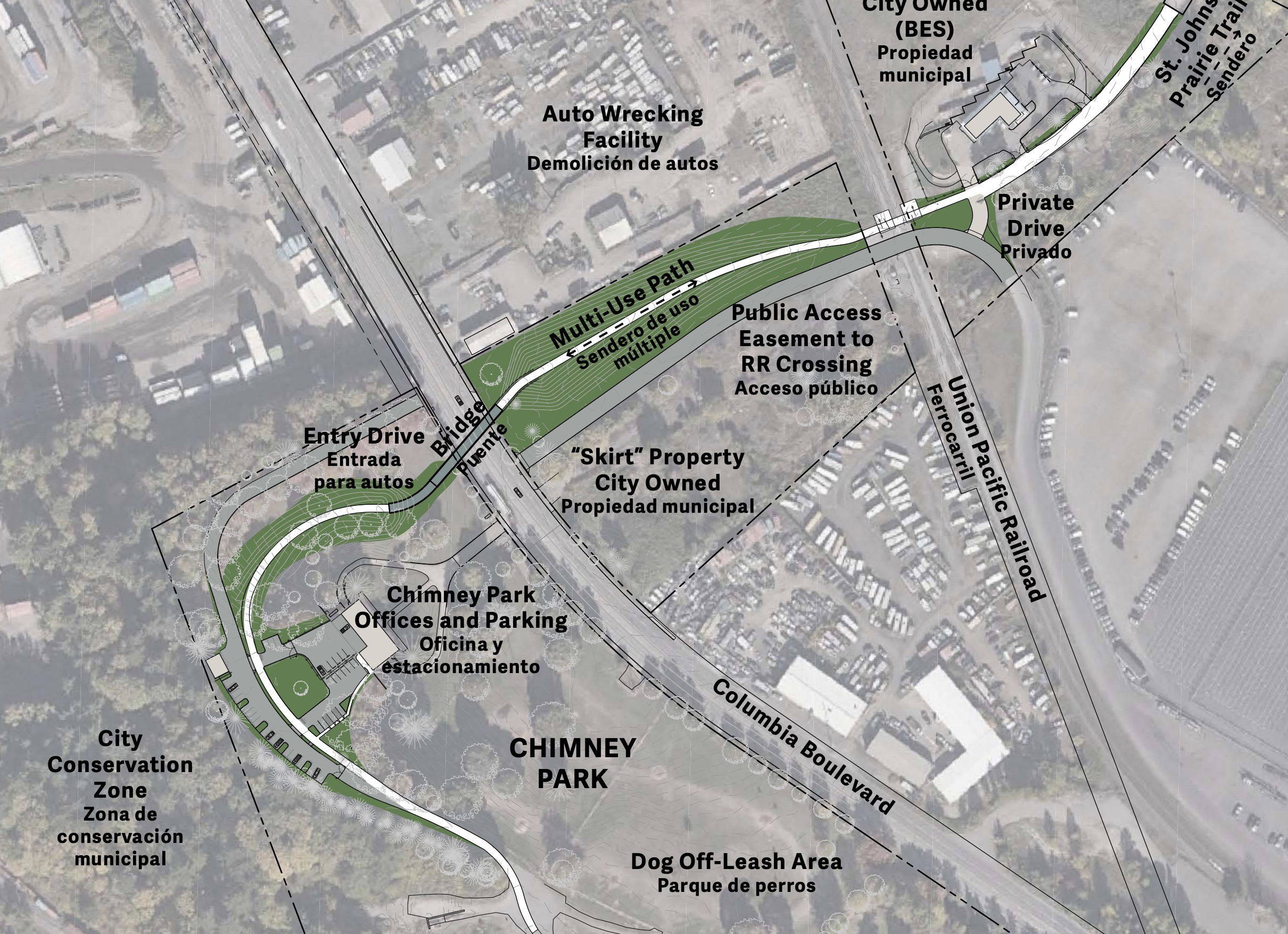
This project will construct a new path and bridge that will connect Pier/Chimney Park in St. Johns with Metro’s St. Johns Prairie trails. This is a key piece of the North Portland Greenway that will also close a gap in the popular 40-Mile Loop Kelley Point Park route. Once the bridge and adjacent paths are complete, we’ll be one step closer to 100% carfree access between north Portland neighborhoods (Piedmont, Arbor Lodge, Kenton, St. Johns) and Smith & Bybee Lakes
Planning on the bridge began in earnest last fall and today PP&R has opened up a public comment period. There’s a new online open house presentation (PDF) to peruse and a survey to collect your data and feedback (online open house closes May 31).
Advertisement
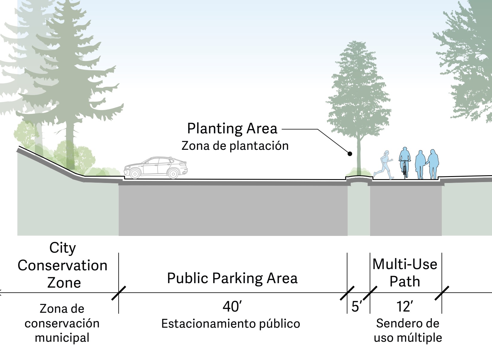
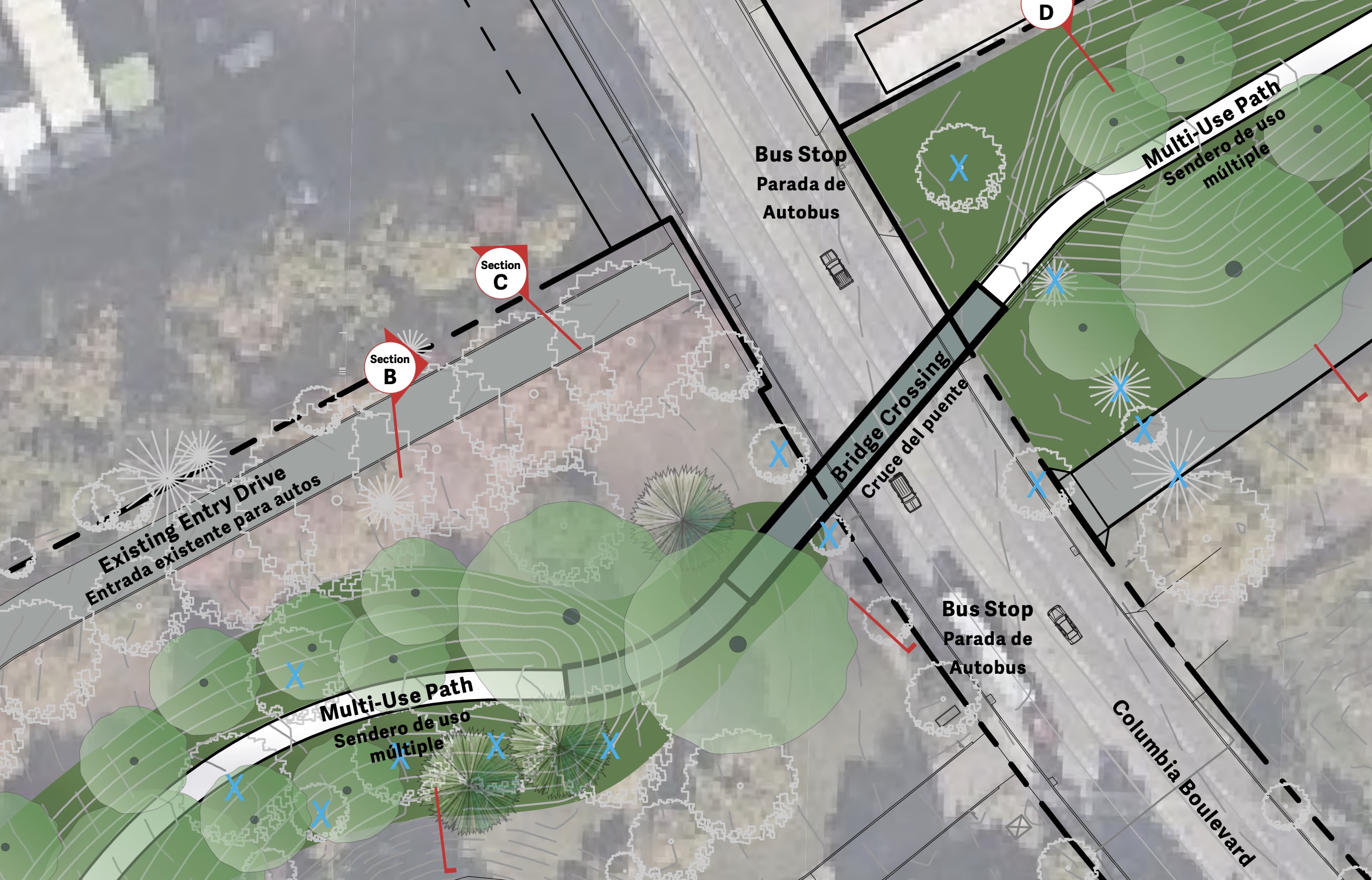
As you can see in the renderings, the bridge should be very bikeable. It will not have stairs or an elevator and will instead have an ADA-accessible ramp that Parks says will allow, “for the widest possible range of user experiences”. The path itself will be 12-feet wide with one-foot gravel shoulders. In addition to the crossing, the project will include new sections of path on either end.
Here are a few more slides from the open house:
The project is being led by PP&R with funding from system development charges, Metro and the Oregon Department of Transportaiton. Construction is likely to begin in 2022.
— Jonathan Maus: (503) 706-8804, @jonathan_maus on Twitter and jonathan@bikeportland.org
— Get our headlines delivered to your inbox.
— Support this independent community media outlet with a one-time contribution or monthly subscription.


Thanks for reading.
BikePortland has served this community with independent community journalism since 2005. We rely on subscriptions from readers like you to survive. Your financial support is vital in keeping this valuable resource alive and well.
Please subscribe today to strengthen and expand our work.
When looking at the cross-section showing 4 people packed into a tiny area, adjacent to a huge swath of paved area, I had exactly the same thought as your caption. I think it might be a lot nicer if that area were planted with big native trees rather than paved with asphalt. You know, heat island, habitat, climate change, and all that.
I was initially super-excited for this project and the St Johns Prairie to come to fruition but now I can’t help to think of what shit holes the Peninsula Crossing trail and Springwater Corridor have become.
I hear you Steve. In fact, I’ve been hearing this from many many many people lately. The issue deserves more scrutiny… but you recall how fraught the topic was even when we were not in a pandemic. I’ve been thinking about it a lot and just haven’t found the right and sensitive way to breach the topic without hurting anyone. Haven’t given up, just still thinking on it.
Yep, I hear you, the houselessness crisis is an ongoing issue, I just wish, at the very least, the encampments would be provided garbage service.
I’ve lived in places where I had to haul my own trash to the dump (or, in this case, dumpster). I don’t feel like that’s a huge ask.
What would happen if I just started dumping my household garbage on the street in front of my house? Would the city pay for and bring me a dumpster to use? For some reason it seems like there is a separate set of laws for the homeless.
I think the city would prefer that you put your garbage in your garbage can – you know, since you have one.
The problem is that when the homeless make a mess of every MUP in the metro area, neighbors and voters are much less likely to support non-motorized path options in the future. Some suburban areas have already cancelled expansion of the 40 mile trail due to what residents see happening on the Springwater and 205 paths. During this Covid crisis I’ve seen a huge increase in camping next to bike paths and mountains of trash littering the area around every camp.
There are. but sometimes it is cheaper to spend a little money than none at all.
Remind me again why there’s a parking lot?
Park and Ride or Park and Run.
At this spot? For me, and many others, they drive there to go to the off-leash area..
As far as I can tell it’s basically the same parking area as currently exists for the dog park, just finished and organized rather than the existing haphazard status. Parking is necessary for the dog park, and will be helpful to some of those that’d like to use the new trail.
I am surprised how many people load up into their cars to go biking. I guess not many feel safe biking from their front door?
Given Covid-19 and the likelihood that we’ll still not have an effective vaccine for another 5 years and the resulting social distancing we’ll continue to follow long after this bridge is completed, why are there no connecting ramps from the Columbia buffered bike lanes to the bridge on both sides? Why the grade separation?
5 years?
Apparently the record for first identifying a terrible new virus and developing an effective vaccine for it was 5 years. There are numerous major viruses that still do not have effective vaccines, including the common cold.
The common cold is caused by a corona virus.
Most varieties of the common cold are caused by rhinoviruses, of which there are about 100 varieties. There are 4 known coronaviruses which cause “common cold” (upper respiratory infection) symptoms: about 15% of common colds were found to be caused by a coronavirus strain in some studies. There is no vaccine for the common cold because it is difficult to make a vaccine for 200 different virus strains and because the common cold is a mild illness.
Remember the Toyota Corona?
There are buffered bike lanes on Columbia Blvd? To the west at the intersection with Burgard, yes, but not here.
You are correct, I’m conjecturing. I’m assuming that within 3 months there will be a pop-up bike lane on Columbia and it will eventually become permanent, given the local government’s understanding of Covid-19, which is not the same as science or even practical logic.
Take a look at the bad planning of the West Burnside bridge for the Wildwood Trail. It has no stairs to connect the path to and from Burnside. It was a bad move.
Am I correct in thinking that this new bridge will carry bikes and peds over Columbia Blvd (a very good thing) and then dump them by an at-grade crossing of the UPRR tracks? (the “private” crossing in the image). I can remember waiting for 10-15 minutes for a train to move at this location and then giving up (I did think for a nanosecond about trying to scoot underneath the stopped train).
Will this bridge cross both Columbia Blvd *and* the RR tracks?
Yes. It would be a little bit unfortunate if we’re willing to spend $25.8 million to ensure that trucks don’t have to cross that railway line at-grade, but not willing to spend a smaller amount to so that the trail stays elevated until after the railroad tracks.
If the bridge had to be 25+ feet high where it crossed the UPRR tracks, would it have enough room to land?
The large triangular parcel east of the railroad tracks is owned by the City of Portland, and looks like it has plenty of room to bring an elevated path back down to grade.
Don’t get you hopes up too high. The railroad probably has a legal 100 foot easement on either side of the tracks (which has obviously been violated my many land owners in the area, including by the city). No city or state has an easy time negotiating with railroads; railroads have eminent domain over cities and states, not the usual other way around. On the other hand, railroads really hate trespassers, so they might be willing to accept a bike bridge to keep people from trying to access their land and tracks if there was also a 25-foot high fence with the bridge paid for by the city running the length of the city property.
I was mistaken about the place where the stopped train blocked the at-grade crossing: it’s further south and east, near N Portsmouth Ave, where you have to cross the tracks to reach the path that runs near the wastewater treatment plant.
Anyway, I’m still unclear about whether the path will now cross both Columbia Blvd and the UPRR tracks, but I hope it does.
I live very close by and hope to use this bridge frequently. I’ll be honest, though, rather than doubling the cost of the project to keep me from the possibility of having to wait 10-15 minutes on a leisurely bike ride, I’d much rather PPR spend that $XX million on a more important need.
Spots further east on Columbia, like the crossing where the tracks head south to Swan Island, see much more frequent train use, and even there I don’t get stuck at the tracks that often. I’ll save the energy, and be happy PPR saved the money, for a more pressing need.
Agreed. This particular section of track sees very little traffic. I think a grade-crossing is acceptable. I’d much rather have them spend money to resolve the grade crossing in the SE 12th/Division vicinity.
What is the bridge actually for? I appreciate it gets you over Columbia Blvd, a busy road. But there doesn’t appear to actually BE anything on the other side of that road, other than a city dump.
Former dump is now a vast meadow, but to answer your question, there are the hundreds of jobs (thousands?) in the Port of Portland Rivergate complex north of the bridge. Persons using bikes for transportation will be able to bike to work without having to cross the literally death defying Columbia Blvd.
Actually, accessing Rivergate and Kelly Pt park is pretty easy and safe if you use the MUPs and protected bike lanes already in place.
How would they do that? Chimney Park is not safely accessible from any part of the city except St. Johns. Just more “islands of safety” with speeding cars and unprotected bike lanes in between.
Looks like the bridge is supposed to connect to an as-yet-unbuilt MUP that will allow you to ride north and connect with the paths near Kelley Point Park.
This would be welcome, but I’d rather have safer access across N Columbia Blvd at Fiske by the the Water Treatment Plant where there is access to the Slough Trail. It is extremely dangerous for all bit the most confident and able-bodied cyclists and runners, but families and other cross here because the only other way in to the New Columbia neighborhood is long detour to Portsmouth St with a steep incline. Plus, even with the stoplight, the crossing at Portsmouth is not much safer.
This bridge doesn’t join up to a path to Kelly Point Park yet? It just crosses to the historic landfill?
The next step would be a bridge over the slough, connecting to the ‘Port of Portland Trail’,the stub trail from Kelley Point to near where the bridge would cross. Since the “Prairie” was built on a former landfill (and a designated Superfund site) engineering to build a bridge will be tricky and expensive. One cannot disrupt the engineered features designed to contain flow of contaminants to the Slough. My guess is it will take a long time to move on this new bridge across the Slough.
The “Project End” of this bridge and trail segment looks to be right on City Dump Rd like 100 ft before the bridge that’s there. It looks like they plan for that to be the bridge over the slough, even though it’s not discussed. It makes perfect sense–that bridge currently serves nothing.
That bridge is the existing connection to the old landfill. Go get across into Smith and Bybee you will need to cross the slough which will require a new bridge
npGreenway (aka Friends of the North Portland Greenway) is very excited about this project. The CB Bridge will take non-motorized travelers safely over one of the busiest freight routes in the region. Metro which owns the old St Johns landfill, now the St Johns Prairie, intends in the same timeframe as the CBB project to extend the Trail another mile around the east end of the Prairie and up to a viewpoint that overlooks Smith & Bybee Lakes. And eventually the Trail will continue around the north side of the Prairie and will then need to cross the North Slough on a very complicated bridge to get to the old Port of Portland segment. The Trail will cross into the Prairie on the existing South Slough bridge that now carries the access/service road. Most UPRR traffic to Rivergate is on the double track under the Pier Park-Chimney Park Bridge, opened a few years ago. The existing at grade crossing is for a less used single track…be glad its an existing crossing as new ones are damn near impossible to get!
Note that Chimney Park is not only a major dog park, but also a maintenance center for Parks; they make use of the old incinerator building…hence the name, Chimney Park. The CBB project does not to my knowledge increase parking, so much as organize it for both Park employees and dog park users. The project includes new trees and landscaping.