
It’s not everyday that plans for a new street come across my desk. Read that again: Not new plans for a street. Plans for a new street! Yes, the Portland Bureau of Transportation will finalize designs this year and break ground next year on new streets in Old Town. Specifically, they plan to extend NW Johnson and Kearney Streets from where they currently end at NW 9th about one-tenth of a mile east to NW Station Way/Union Station.
The work is part of the Broadway Corridor project, a redevelopment of the 34-acre former US Postal Service distribution site being led by Prosper Portland. Not only will this site be home to new commercial and residential units, it will also be a key link in the future Green Loop, a biking and walking path that will eventually ring Portland’s central city. The Broadway Corridor has been in the planning stages since at least 2015 and reached a major milestone last month when demolition of the USPS facility was completed. Now that the slate has been wiped clean, it’s much easier to get excited about building on top of it. It’s even more exciting to see what type of street design PBOT will build when given the chance of starting from scratch.
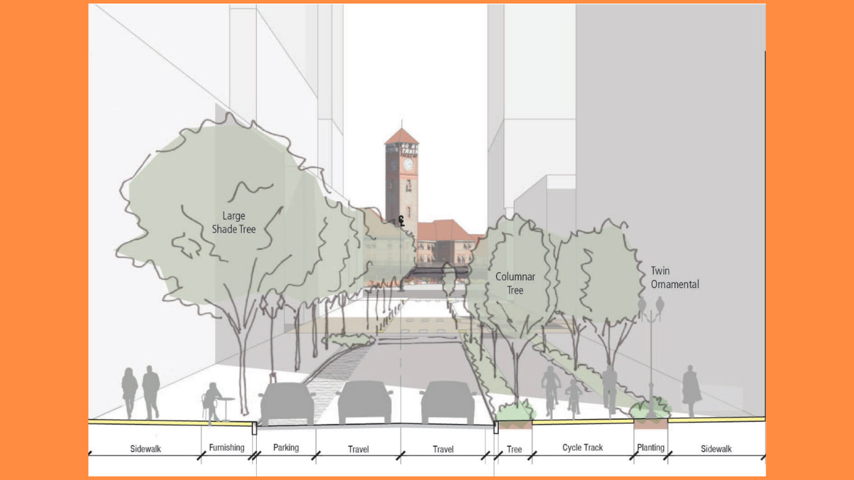
On a new website for the NW Johnson & Kearney Street Extension Project, PBOT gives us our most detailed view yet of what we can expect. The conceptual cross-section drawing shows a street with two general lanes, an on-street parking lane, and a wide sidewalk separated from a two-way cycle-track by large trees.
Check out the latest drawing below of what a brand new NW Johnson Street between 9th and Union Station could look like:


PBOT says in addition to the extensions of Johnson and Kearney, they will also build new bike lanes on NW 9th between Lovejoy and Johnson (this will create a stronger connection between existing bikeways on the Lovejoy viaduct that connects to the Broadway Bridge and the neighborhood greenway on Johnson).
To pay for this project, the City of Portland created a local improvement district (LID) with Prosper Portland. A LID is where a group of property owners share the cost of new infrastructure and get generous terms on a long-term loan to pay for it — with the first payment not due until after the project is completed.

If you’re as excited about this as I am, you should get plugged into a related project: the North Park Blocks extension being managed by Portland Parks & Recreation. That project will extend the existing linear park that exists between W Burnside and NW Glisan north to Hoyt (behind Pacific Northwest College of Art, which is why some folks refer to this as the “PNCA Block) in order to tie into the Green Loop and Broadway Corridor. The result will be a new, 30,000 square foot park. There’s already an advisory committee that has met and ideas the planning and design process is expected to continue through this fall with construction starting in spring 2026.
It just so happens that the first community open house for this project is tonight (Thursday, February 29th). Learn what the future will bring and how you can get involved by dropping in any time at PNCA (511 NW Broadway) between 6:00 and 8:00 pm.
These projects could not be happening at a better time as Old Town emerges from the pandemic and Portlanders begin to demand excellent public spaces where we can enjoy our city.


Thanks for reading.
BikePortland has served this community with independent community journalism since 2005. We rely on subscriptions from readers like you to survive. Your financial support is vital in keeping this valuable resource alive and well.
Please subscribe today to strengthen and expand our work.
For the North Park Blocks Extension, you write, “That project will extend the existing linear park that exists between W Burnside and NW Hoyt north to Glisan.” Don’t you have Glisan and Hoyt reversed? The park goes to Glisan now and would be extended to Hoyt. BCDEFG+H
Yes my mistake. Thanks. Fixed it.
This is exciting: these new streets are not constrained by width, or current car traffic volumes/patterns in terms of what is politically feasible to do on them. What the final design ends up being will be a test of how much PBOT truly values active transportation.
The lack of raised crosswalks, a.k.a. “continuous sidewalks”, is a missed opportunity for PBOT. Especially with the freedom of designing a street from scratch, you’d think they would use the safest & most pedestrian- & bike-friendly design. If anyone hasn’t seen the Not Just Bikes video about this, it’s a must-watch: https://www.youtube.com/watch?v=_ByEBjf9ktY&t=746s&ab_channel=NotJustBikes
In the furthest left picture, it has a label pointing to a “Raised Crossing”. It appears the part of the street between Park and 8th is all at sidewalk level as well.
Good catch, thanks.
But the other end of the street is shown with regular ADA ramps down to street level. Seems like a weirdly ad hoc approach to pedestrian safety. Would be interesting to know if the Pedestrian Advisory Committee has any input on this issue; the updated Pedestrian Design Guide has a chapter on “corners and crossings” which is currently blank: https://www.portland.gov/transportation/planning/documents/pedestrian-design-guide-2022/download
Will the extensions of Johnson and Kearney go under the Broadway viaduct to reach Station Way?
yes, both Johnson and Kearney were shown tonight to reach station Way under the Broadway viaduct. PBOT was not present at the open house tonight. Only the Parks Bureau and their designer.
Looks really nice. I’m a big fan of the “curbless” street and paver surfaces. I like the two-way cycletrack too. Will be really cool to see this come together.
Just throwing this out to see if it sticks to the wall…
…HOW ABOUT, planning ahead and using some of the new underground space that this development / street + park will create to build an underground ‘bikestation’ mobility hub especially as it is next to the regional rail / x-bus station??
In the same vein, there should be planning for the inevitable MAX tunnel to use this site and have a station on or near it connecting to Union Station.
Yes – just like Amsterdam.
“Just like Amsterdam’s Centraal Station” BUT without the 10+ year construction period. 😉
If it’s 10 years in Amsterdam, it’ll take 20 in Portland.
Antwerp might be a better comparison to Portland, they too run part of their light rail tram under their downtown streets near their station.
Ideal, of course, would be a Red Line subway station under Union Station, just like in DC…
Ultimately, wouldn’t it be better to run a Portland subway under Union Station, perpendicular to the surface UP/BNSF railroad tracks, so Amtrak can have escalators running direct from the subway platform up to the train station platforms?
why are the radii so generous where Johnson intersects existing streets?
It appears that this design will encourage high speed right turns….
very perplexing.
Fire trucks maybe?
I would like to be positive, but this is extending the park to where there is no surrounding development. Even if it were, almost half of the area is cut off by viaducts.
Is this where we put parks? In corners? Not a great way to bring people in.
But won’t there be new development on all three sides of the extension? There’s a full block of developable depth on each of the three sides of the park extension.
And there are viaducts only on the north and east, and the new street will connect eastward, so all the area will be accessible from at least the east, south and west.
The new park space will connect directly to the Park Blocks to the south, and be surrounded by new development, which will benefit from having the park in the center. It seems like a perfect place to locate a park.
Two of those sides are one block, cut off to the north and east by the Broadway Bridge viaducts. If housing is a plan at all, it’s going to take a lot of ambition to compensate by building tons of units at market or any other rate with the kind of views it has and will obstruct.
I used to live on the North Park Blocks. In my experience, making it an asset instead of a liability was already tenuous and I don’t believe that remote work or the relocated Under Armour office has improved that situation.
Having the viaducts there isn’t ideal. But they’re low, the streets will connect under the east one, and the sites have open access on the other sides. Having an elevated street (or train) on one side of a site is a common urban situation, and designers have figured it out even on sites that aren’t large, or open on the other sides, as these ones are, and in cases involving much higher noise and traffic.
If designers can work with development sites that are only open on one or two sides (every non-full-block apartment building in Portland is an example) they can deal with full-block sites with a low viaduct on one side (or two at the corner) and a park on the other.
The current Park Blocks obviously have problems, as does the whole development climate. But the street and park extensions still seem to make sense even if development around them is delayed, given that they’re decisions that have to work for the next century.
OK. New street with bike infrastructure (a whole 1/10 mile!)
After the ribbon cutting, what is the plan for maintaining the nice new street and park? Are tenants lining up for residential and retail spaces along the new street? (Remember, a lot of empty retail and restaurant space in The Pearl right now for various reasons)
I want to be positive about this development, but the city doesn’t seem able to adequately take care of or protect new things after they are built. The “game changer” Blumenauer Bridge is already blighted with tagging.
This is a miraculous chance to connect the Park Blocks to the Willamette River. Yes, we would have to build a wildlife corridor over the train tracks but what an opportunity.
The city owns undeveloped waterfront to the north and so it’s mostly parking lots, bridge ramps, and railroad tracks.
Could be the funnest hump in N. America.
I love the idea of a living bridge and recreational connection to the river, but I am not understanding the habitat value of a green connection from the river to the park blocks. The Park Blocks have a lot of canopy which is great cover for birds and squirrels. The birds don’t really need a continuous canopy to access the river, and squirrels don’t benefit much from river access. Likewise, the beaver and amphibians in the river would not benefit much from access to the Park blocks. I think the greater value would be for a simple recreational bike/[ped connection to the river and more $$ spent on riparian habitat development. I am curious if I am missing a group of species a that would benefit from this wildlife corridor.
The 2-way bike design seems counterproductive to adding to a bike/ped network. It is totally different than the rest of Johnson/Kearney and it only 3 blocks. I think it would be a lot more valuable to build a raised bike lane on each side of the street so the bike lanes could seamlessly connect. A 3-block cycletrack is useless and frustrating and potentially dangerous. Also, having the bike lanes cut trhough the plaza is a hostile move to making a comfortable, functionally plaza- keep the traffic on the outside of the plaza, not through the middle. This looks like very poor design work, unfortunately.
The whole project is very disappointing to me. It seems like a huge missed opportunity. A giant parcel of land comes available downtown, and it is turning into more of the same instead of a large signature attraction (concert venue, open-air market, ball park, etc…). More office/retail buildings that we don’t need, more high-priced condos that we don’t need, more streets for cars that we don’t need. They don’t even have the vision to see a space free from cars and set aside for other forms of mobility-this does not move us closer to our climate and safety goals. Very boring design and I’m unfortunately not excited about it.