The City of Portland hosted its second open house for the North Parks Blocks Extension project last night.
As we shared back in February, the Parks & Recreation bureau is looking to extend the existing linear park that exists between W Burnside and NW Glisan, north to Hoyt (behind Pacific Northwest College of Art, which is why some folks refer to this as the “PNCA Block). The project looks to design a new, 30,000 square foot park. It was spurred by the Broadway Corridor development and will also be a key piece of the future Green Loop.
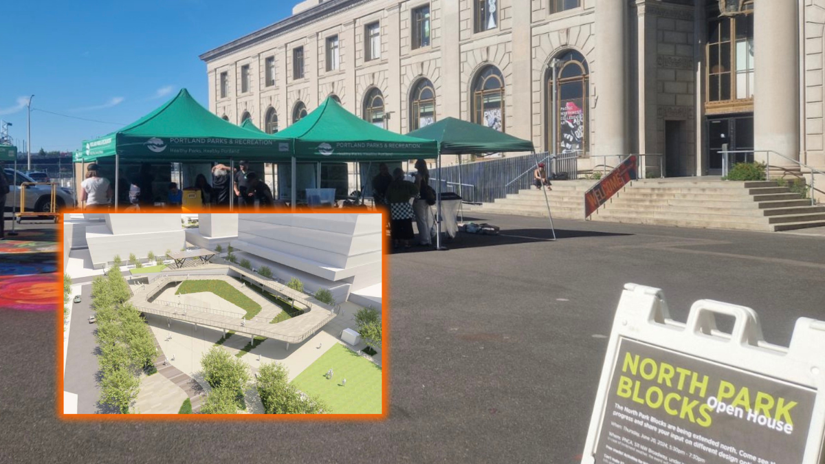
Last night under tents in an outdoor plaza outside PNCA, design consultants and city staff unveiled three new design options. The designs were gleaned in large part from over 500 public comments received at the first open house on February 29th. The new renderings give us our clearest view yet of how we might some day pedal our bikes from the North Park Blocks, through the Broadway Corridor, and onto the western end of the Broadway Bridge at NW Lovejoy.
The design team shared three options at last night’s event: Option A, Quilt; Option B, Table; and Option C, Clearing. Each option consists of landscaping, infrastructure, and other elements that could help define three blocks of park space between NW Glisan and NW Johnson (which will be extended through the site as part of this plan).
Check them out below:
Option A: “Extend a quilt and celebrate”


Option B: “Spread a table and invite”


Option C: “Reach a clearing and congregate”


Learn more about each option in the presentation graphics shared at last night’s open house.
If you have feedback, stay tuned to the project website for news of upcoming open houses and surveys. You can also contact the project manager via email at gary.datka@portlandoregon.gov. Construction is set to begin in 2026 with an anticipated opening in spring 2027.


Thanks for reading.
BikePortland has served this community with independent community journalism since 2005. We rely on subscriptions from readers like you to survive. Your financial support is vital in keeping this valuable resource alive and well.
Please subscribe today to strengthen and expand our work.
I do really like #3 but I feel like these are all missing the nice shady “portland” vibes, I feel like these all look like the new parks I saw when I visited NYC last. I am on a small screen so maybe I am missing something but isn’t this the park that has a devoutly used basketball court? is the court removed?
(not complaining too much, I promise, it seems like all the parks downtown need some TLC, I hope they do a full revamp of the very sad waterfront park next)
The basketball court is on the block south of Glisan. This project extends the N Park Blocks north of Glisan.
I think I prefer C of the bunch. Playground? None of the options has much built infrastructure for “fun” — it’s just paved or landscaped space. A few logs or boulders can provide fun climbing and blend in well with a natural landscape.
PP&R continues to cripple itself by refusing to allow any commercial activity in the parks. What about a concession stand for food/drink? Why not license small coffee or ice cream carts? Seems like a no-brainer to promote bike-based carts.
I tentatively agree with you- some parks like waterfront park, this is greatly needed (in addition to about a million others things mostly importantly CLEAN FUNCTIONAL SAFE FREQUENT toilets), but this part of town is flanked by small businesses & vacant buildings. one simply needs to cross the street to get ice cream/coffee/food, as the park redevelops, these vacant store fronts will fill up as well.
but my biggest problem is that our country loves capitalism and before you know it, a Black Rock coffee cart is going to be on every corner. if they could somehow award these contracts to small Portland businesses, i’d be much more inclined to support this idea. in Mexico city, we visited an incredibly beautiful diverse park that had a book store/coffee shop tree house in the middle <3 oh to dream!
Yes! Playgrounds. Downtown is light on options for kids and families to play. Tom McCall Waterfront Park, for example, is missing anything for kids (who are often not interested in a leisurely stroll). The park blocks are the same and could benefit from a play structure, climbing wall, etc.
The Park Blocks have playgrounds at either end: one at PSU and one at PNCA, but other wise yeah, it’s a little sparse for kids downtown.
I wish you could explain each option a bit more. I’m not really sure what I’m looking at.
Squiggles in the path aside, Option B would be the best for biking because it eliminates the switchback ramps. However, I wonder how pleasant that plaza in the center of the ramp would be.
The spiraling ramps for bikes in B would be nice, but I’m not seeing a staircase for pedestrians. If there isn’t a stair in there somewhere, I’d prefer the other two options in order to get the stairs. The wiggly path seems like a designer getting a little too cute drawing up a neat site plan at the expense of practicality.
I agree that the plaza space in the option B north block might not be all that great, but I’m also not sure that option C would be any better there. Seems a bit like option C provides a few semi-isolated stair landings tucked between the vertical ramp walls. Maybe A without any plaza space would be for the best? I guess with option A, people could hang out on the sloping grass, sunbathing and whatnot?
I like the idea of not having switchbacks, but I wonder if the option b design would require a more expensive and complicated ramp construction. Does parks think all three designs are equally feasible from a cost perspective?
All these ramp options are bad. Close the east intersection of Irving to cars and extend the ramp mostly straight south, maybe with a little bit of a curve, touching down at the end of the block. You can let pedestrians walk under the ramp at Irving, thought the clearance may be too low for cars.
So, the PNCA site isn’t referred to as the ‘Old Postoffice’ block anymore? I guess that probably makes sense since the ‘new’ post office that was built to replace it has been torn down.
I generally really like and appreciate these three concepts. My biggest ask for any public space along the Green Loop has been thoughtful consideration for through access for people walking, biking, and rolling, to help finally realize the Green Loop as a connected linear park, and help bring a continuous flow of lively visitors through these special places.
You wouldn’t think you have to ask for that, but you do. Some park concepts for downtown, even on the Green Loop, are all about keeping people out vs inviting them in and through.
Portland Parks has a great opportunity here to step up their connectivity game in the spirit of the original Olmsted plans. I feel like PLACE is delivering that with each of these options, and I was pleasantly surprised to see the confidence and functional simplicity of these proposals at this second open house.
I think they can still use some support that they are on the right track, and possibly some nudges to get the placemaking details even better on the next round of revisions.
Several of my post-its from the first open house are represented directly in these designs, so they are listening.
You can provide your encouragement and input via their online survey before July 1 at 9AM: https://www.surveymonkey.com/r/5WNKFM2
Thank you for the reminder about PBOT’s July 1 survey deadline. I couldn’t attend the open house last night. However, I’ve been participating in a standing monthly SOLVE cleanup event in the North Parks Blocks for a few years and regularly do photowalks through the Old Town Chinatown District. I’ve also walked the proposed Green Loop a few times with an eye to see what would be beneficial from a pedestrian’s standpoint. All said, I want to weigh in with my thoughts while they’re fresh.
A postscript, but only indirectly related. Thank you to the City of Portland staff members who participated in SOLVE’s Holladay Park/Lloyd District cleanup yesterday. And thanks to the SOLVE event coordinator, if you should read this, who gave me the water. I gave it to the man, who was unsheltered and lying in the sun. The 911 dispatcher led me to think that they would send PSR to check on the man. I couldn’t stay to see if or when they showed up. I expect they were very busy yesterday.
Here is some additional background (context) for my postscript above.
The following excerpts are from an email I sent to the Lund Report. On 9/8/2022, Emily Green included them in her article: Readers Respond To Series About Meth’s Impact On Oregon’s Behavioral Health System
Below you’ll find excerpts, published with permission, from some of those emails, along with a selection of social media comments.
Emails
I’ve been exploring the Portland metro region on foot for the last 12 years. Over the last two years on my photowalks in the metro region, I’ve seen the outcome of our failed behavioral health and addiction treatment systems at street-level, first-hand.
I also see this in the SOLVE events I regularly participate in. During the events, I try to take time to hear the stories of those who are now living on our streets. Some of the stories I hear are incredibly tragic.
Yesterday, when I did a photowalk along the proposed Green Loop on the inner Eastside and downtown, I was reminded once again of our failed systems. The number of people I saw in distress was troubling. The leg of the Green Loop route from Burnside to the Broadway Bridge is particularly alarming.
I’m always amazed by Americans. They travel to Europe and Asia, admire those cute old world cities and towns with irregular medieval twisty streets and alleyways, then when given an opportunity to completely remake an inner core of their own cities with brand new blocks, can think of nothing better than to replicate their existing boring grid system exactly.
Separate from the lack of creativity, I see this being similar to how conservative Baby Boomers collect SSI and enjoy their MediCare while decrying socialism and voting for candidates that belong to the party that has been trying to abolish both since their introduction.
Or maybe how middle-aged generation x’ers and y’s, big fans of the Quality-brand Surly and Salsa bikes and who never vote anyway, so easily switch now to e-bikes and think they are still cool and hip and alternative?
Maybe it’s the middle aged Gen X in me, but I don’t support the idea of building a faux medieval city center on the post office blocks.
I can’t fathom how a screed about people that ride QBP bike brands or e-bikes is even vaguely related to the topic of extending the north park blocks.
I like the boring grid system in our city.
Countless streets and neighborhoods that are incredible places to visit and live in are on gridded streets.
Also, laying out new streets in an intentionally irregular and twisty fashion may have a much less successful outcome than the European and Asian ones that generally have evolved over centuries.
As a cyclist, I hate tight z-turns on ramps. So I prefer option B. I also like B’s “squiggly” bike path. It will force cyclists to slow down, which is entirely appropriate in a park.
Mark, I also dislike tight turns on a bike route and I dislike bike/ped conflicts. I believe that one of the goals for the Green Loop is to provide a cycling loop in addition to a walking/jogging route and placemaking. The connection to the Broadway Bridge could be very useful for cyclists and for activating the new park. I hope PBOT and PP&R will come to their senses and abandon these unnecessary compromises. An efficient bike route is not a great fit within a park, especially when if bisects the park spaces. Likewise, park spaces where people are encourages to linger, or wander or gather are not great places to move through when using a bike for transportation. Since this space is being created from scratch, the bike as transportation and the walking /park functions should be pulled apart. Having them both will definitely make the park more successful, but they should not be in the same constrained space and they should not cut up the park spaces. I recommend keeping the transportation functions on the edge along Park Ave. Ideally, a bike-only ramp could connect the Broadway bridge to north and south lanes of Park Ave. Sine Irving will not go through, I think the ramps could extend across Irving. The ADA ramp and stairs could then be incorporated in the east and north portion of the site, leaving the center more open for park functions.
Overall, I love A (give me some grid right into the veins!), and C could be lovely, but I have reservations with how similar it looks to the old O’Bryant Square and issues with sight lines. I hope they take some lessons learned there. I also think a huge aspect of an urban park’s success is the surrounding activation of building frontages, which is where O’Bryant seemed to lack the most of.
And for B…I’m not a fan. Atleast the squiggly meandering path part. Its a great example of what looks good from a plan view, but down at ground level: doesn’t equate. Pedestrians and people on bikes will for sure just take whatever paved path they feel like and it’ll always be a point of contention for mixing modes. I also don’t know about the spiral ramp without a stair option.
Nonetheless: a lot of awesome work here. Pretty exciting either way!
I agree with all that, including preferring A.
Most successful public urban spaces are incredibly plain in plan–usually a rectangular paved space or lawn, maybe with some trees around the edges, and some benches. The really deluxe ones may have a fountain or statue of somebody.
The ones that often seem less successful are ones (like O’Bryant Square that you mentioned) where designers seemed to feel that plans had to look exciting on paper, with lots of angles, grade changes, materials, etc. B and C (like you, I prefer C) give me pause because they remind me of those.
I admire all the work, too, and appreciate the combination of views of each that describe each design so well.
B seems to offer the best circulation option, but they are petty bad. Each option creates a huge, convoluted elevated path that takes up/compromises the space for the entire park block. Why is this path restricted to the footprint of the park? Surely bikes and peds could be segregated for this connection. A smaller, narrower (10′) ped-only path could meander up the east and north portion of the block and integrate a staircase and switchback if required. The bike lanes could be steeper/shorter and probably align with Park Ave. Also, Irving street does no cross the park, so why not extend the ramp to Hoyt instead of all the contorted switchbacks or spirals. It seems clear that PP&R is acting solo on this and not partnering with PBOT, which is not a good sign for the Green Loop. The Green Loop NEEDS to function as transportation and be fully connected/integrated to live up to its promise. I would send all of these concepts back to the drawing board.
Mayor Vera Katz had an opportunity (costly, but was an option) to connect the North and South Park Blocks. She didn’t.
This is a similarly unique opportunity to connect Park Blocks and Willamette River. While the on-ramps to the Broadway Bridge and the railroad tracks present design challenges, the only other stuff in the way is a couple parking lots. This is a once-in-a-city’s lifetime opportunity to connect to the river!
We could build one of those wildlife corridors over highways but instead it would be over the train tracks and for people. How fun to have a big green hill to climb over to get to the river or to sit on and watch a concert below.
How great to walk through the city, go swim in the river (which might be clean by then), and walk back, all through park.
Forest Park is part of our fame and draw. Why not strengthen our inner city park by extending North Park Blocks all the way to the Willamette River?
Can they please pass these through a CNN or some other machine learning module. It should not be complicated to see if the desired outcomes of the spaces (labeled throughout) would be so far off from a machine prediction, based on already gathered data from existing spaces. These design diagrams often seem disconnected from reality because they are so aspirational. Just be real. AI is still pretty dumb but it could tell us an array of uncomfortable but realistic outcomes which might inform basic changes to the design or suggest the tabling of certain options.
Sun, Shade, places to sit, food and water are the basic building blocks of small urban spaces. https://www.dailymotion.com/video/x8mpdo3 and https://vimeo.com/42180465 the park will be dreary and empty if all five things are not included. And the spaces should be built to human scale.
Perhaps instead of “activating” space for bougie condo owners we could deactivate the classism of market-urbanist planning by building terribly-needed social (or deeply affordable) housing.
Building “urban renewal” parks in areas that already have a high-density of parks is the urbanist/YIMBY equivalent of building another 5 acre suburban strip mall parking lot.
clicking on the link Jonathan posted at the bottom and really reading all the notes, I am left wondering why one or more people commented that the green loop is a detraction from the site and to not let the green loop take over… what? who hates the green loop downtown and why? seems pretty harmless in my opinion, doesn’t seem to take away beloved parking or cause bottle necks with cars.
I hate the green loop because it would hoover up public and private funding to make the resource rich inner core even more resource rich. These funds could directly and indirectly be used to build needed deeply affordable housing, begin to address generations of racist and classist disinvestment/urban-“renewal”. I also hate the green loop because it’s a classic example of using public space and public funding to juice the profits of amoral real estate speculators.
The Green Loop has enormous potential, but it is an amorphous concept that needs serious design development. The concept of recreational loop is a valuable wayfinding and civic identity tool that can be used as an armature for planning and projects. However, the Green Loop conflates bike routes with park spaces. If done poorly, this puts park users and cyclists in conflict and degrades the value of the green loop as a useful transportation route and compromises the value of the Green Loop as a park or green space. There is a good reason for the current standard for Willamette Greenway development segregate bike traffic from pedestrians- they move at significantly different speeds that are not compatible. Read the comments to almost any story about the esplanade and you will read complaints from people walking or jogging that people bike too fast and put their kid/dog at risk. Or yo will hear from people biking that people on the trail should “follow the rules of the road” and stay to the right and have situational awareness. They are both correct and valid. When riding for exercise or just to get somewhere, it is not pleasant to go at a walking speed, or to stop frequently for a kid wandering around on the path. Likewise, in a park, it is not relaxing to worry about bike traffic whizzing by. These designs are apparently in denial about the function of the green Loop as bike route. I suspect a lot of riders will use this to access the Broadway Bridge or as a safe north/south route. I think this makes sense for a 7 mile loop- it should support efficient cycling. However, cyclist moving at 15-20 mph through the middle of a park is just not good for park functions like strolling a bit aimlessly, letting a child run and explore, or just letting your guard down. Having a strong bike connection to the North Park Blocks will be critical to their success and to the success of the future development, but transportation is best handled outside of park boundaries in the right-of way.
I do not hate the green loop, but I do believe that it needs to be carefully planned and designed to be successful. The designs presented appear to fall far short of successful park designing and planning. For the loop to work, it will need to support efficient bike travel AND have quiet, park-like spaces throughout. These designs conflate the 2 and will propose a bike route with a lot of conflicts and park spaces bisected by a transportation route. If the Green Loop does not intend to provide a bike route, then the focus should be on simply creating a ring of parks, and PBOT should propose a bike connection form the Broadway Bridge to the Post Office Blocks redevelopment. This is a brand new development from scratch, we should expect a higher level of service for our future park and bike routes.
Hey Jonathan, can you post a link to the homepage for this project on portland.gov?