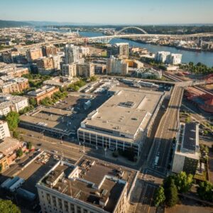

The 14-acre former United States Postal Service site in northwest Portland current sits vacant and it feels even lonelier after a developer who planned to resurrect it backed out back in October.
But the Portland Bureau of Transportation isn’t letting that stop them from moving forward with their plans to create new streets through what’s known as Broadway Corridor. At City Council this week PBOT is seeking permission to apply for a federal grant through the US Department of Transportation’s Rebuilding American Infrastructure with Sustainability and Equity (RAISE) program. The grant program will award a total of $1.5 billion nationwide.
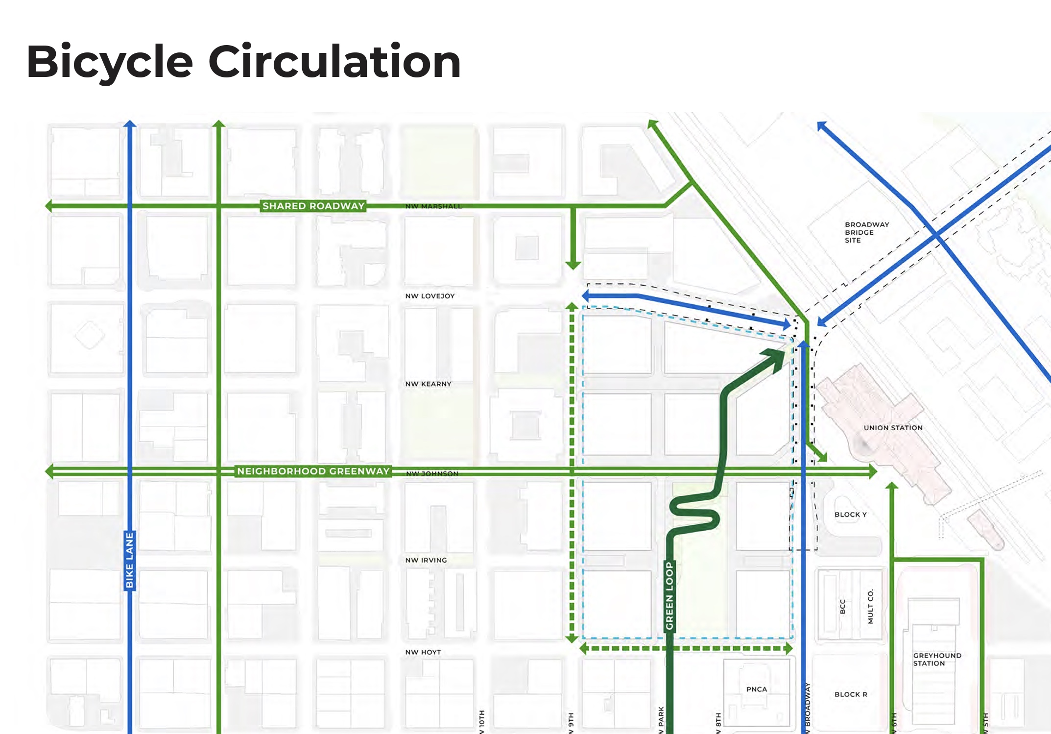
PBOT will seek $15 million of those funds to build six blocks of streets and one traffic signal. The money would go toward a $22 million project (they already have $7 million in matching funds secured) that will allow the bureau to build new sections of NW Johnson and Kearney streets between 9th and Station Way. According to Broadway Corridor plans, Kearney is envisioned as a future pedestrian-focused greenway through the development. Johnson is already a PBOT neighborhood greenway where bicycling is prioritized and the plan is to continue the route through the development and connect it directly to a new Green Loop path, Union Station and the existing transit mall on 5th and 6th. The project would also build a new traffic signal at NW 9th and Lovejoy.
Advertisement
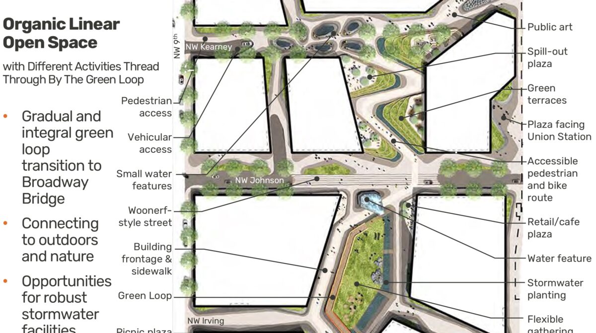
Existing planning documents show Kearney and Johnson playing major roles in what is likely to be a new mixed-use neighborhood at the site. One conceptual cross-section of NW Johnson (above) shows two wide sidewalks, a protected cycling facility and a two-way street for car drivers next to multi-story buildings. Another sketch shows Kearney as an “organic linear open space” with water features, trees, and no through traffic for drivers. Johnson could be a “woonerf style street” for a full block in the middle of the development. Woonerf is a Dutch term for “living street” and it refers to a place where all street users — whether you are on foot or in a large automobile — are equals and the space is shared. This type of street environment is common in Amsterdam.
Broadway Corridor kicked off as a vision in 2015 and planning began in earnest in 2017, but there has been little movement since early 2019.
Learn more about the project at BroadwayCorridorPDX.com.


Thanks for reading.
BikePortland has served this community with independent community journalism since 2005. We rely on subscriptions from readers like you to survive. Your financial support is vital in keeping this valuable resource alive and well.
Please subscribe today to strengthen and expand our work.
This project would seem to be a perfect choice for a car-less plaza or pedestrian boulevards. Why provide any car access at all to the interior of the site? Provide garage access and commercial loading on Broadway, Lovejoy, 9th or Hoyt.
A federal grant partially funded by the taxes that lower-income people pay. How is it that this a priority with multiple interlinked humanitarian crises raging in this city?
Also, so much for Portland’s promises that rapacious real estate developers would pay for the external costs of their speculative developments.
Bingo!
Can we get federal grants for homeless shelters?
Great idea, Chris. The green loop and its real estate “place-making” should be made available for autonomously-run encampments and supportive shelters.
IMO, they should use this superblock opportunity to create an artificial medieval village with twisty cobble-stone streets or the campo of Siena rather than the usual boring American grid.
Kowloon Walled City
A medieval village would be kinda sweet but while we’re waiting on that, the loading dock could be used to tranship truck freight to cargo bikes. Everybody has a wish list but this is actually doable at minimal cost, practically nothing if there’s an existing ramp from dock height to street level.
I would love to see that Organic Linear Public Space happen. But I’m pretty sure it’ll end up the usual nightmare of two way traffic and parking, with the typical too-narrow sidewalks hampered by street lights and other elements. If they’d at least make them one-way it’d be a lot less chaotic. Or even better, give it the NW 13th treatment.
Soooo the streets gonna have sharrows and lots of motorist traffic then like the rest of our “greenways”?
PBOT is about drop millions to encourage motorized traffic lmao
Unfortunately, PBOT is using its transportation hierarchy to prop up an uneven desk, while the bike plan has become a monitor stand.
they don’t even have a developer! This is ludicrous- they are going to build unneeded streets through a site that will remain empty for an indeterminate amount of time during a time of extremely high constructions costs. Why not just wait for the developer to build it and pay for it with SDCs? In the meantime, that giant building could be used to temporarily house people! I would rather the City built some missing links to the bike network that are unlikely to ever be funded by SDC’s- why not start on the NP Greenway? They could connect the east of the esplanade bridge and build a viaduct under the Steel Bridge and nice path/park at the top of the bank above the river. Or pour this money into a tunnel for the Max under the river and Downtown. My point is that the roads at the Post Office will get built and paid for when there is a project to build something. Until that happens, there is no need for the roads. If the City has $15million to spend on infrastructure, lets build something that will immediate improve travel for Portlanders and would not otherwise get built.
The Design Commission approved the Master Plan for the site in 2020. Johnson is planned as an 80′ special wide and Kearney as a 60′ standard street (see pages 46 to to 54 of the PDF). Buildings would be allowed to have parking access from Kearney, so it’s planned as a street that cars can drive on. Cars can go through on Johnson, but no garage entries are allowed from Johnson.
City Council also adopted updates to the River District Right of Way Standards in 2020. These standards show the design for NW Johnson, which would have extra wide sidewalks and a 12′ wide cycle track on the south side of the street (see pages 105 to 108 of this PDF).
Somewhat unfortunately, IMHO, the only truly car free ‘street’ will be NW 8th (technically not a street, but circulation as part of the extension of the North Park Blocks).
It’s great to see that close-in affordable housing is being planned here and that lots of open space and bike and ped routes will be included.
However, I’m concerned about those switchbacks. It looks like Bikes-on-Sidewalk BS to me.
https://bikeportland.org/2019/08/16/comment-of-the-week-lets-stop-with-the-bikes-on-sidewalk-b-s-303548
Bikeportland readers expressed skepticism about these switchbacks and made some good suggestions when this was first introduced on this blog in 2019. https://bikeportland.org/2019/05/22/elevated-green-loop-path-emerges-from-latest-broadway-corridor-plans-300219
I don’t know why more of that feedback did not come out at ZGF’s Community Engagement outreach events.
One quick brainstorm for the Broadway Ribbon Route: A smooshed-sideways and stretched-out slinky with wide round turns, the path itself wide enough for uphill bike riders and two-way pedestrian traffic. Gangways to connect to intermediate-level destinations. A straight ribbon run down the middle for downhill bike riding fun and expediency. Basketball courts below within the cathedral-like supporting pillars. Petanque/horse shoe/boules courts, playground structures, a wading pool and fountain, and quiet park benches. Compact recreation facilities for all age groups and inclinations, – not just landscaped wetlands/walkways through gardens. Visually striking, functional, fun, emblematic and iconic of Portland Rising.
$22 million dollars?! This is very expensive for less than 1/4 mile of new street.
The 3 blocks are each 220 feet, or 660, center to center, so this is a total of 100k square feet of new pavement: 60 feet x 660 + 80 x 660. At that price it is $220 per square foot of street! Even if we add 12 foot sidewalks on both sides its still over $175 per square foot.
That’s the more than the square foot construction cost of a finished 5 to 6 floor apartment building, just for concrete and asphalt on the ground. Several sources quote a cost of $8 to $11 million per mile for new urban 4 to 6 lane road construction, in the past few years. In contrast, 22 million for 1/4 mile is $88 milion per mile!
It does sound expensive, hopefully they don’t waste all that money.
But to be fair to the estimate, I assume they will be also installing utilities under the new roads and tying into the surrounding system.
$16 million will go to consultant’s fees, feasibility studies, an equity audit or two, and catering multiple listening sessions so that citizens think that they have a say in things.