(ZGF Architects)
The flyover lives.
New renderings and details for the Green Loop through the Broadway Corridor project site have been made available by architects working on the project. They include our most detailed view yet of how the path will navigate from the Parks Blocks, through the site, and up to the 30-foot high junction at NW Lovejoy and the Broadway Bridge.
After a general planning concept was adopted earlier this month, ZGF Architects has just submitted drawings for the site to the City Auditor’s Office in advance of a Design Commissioner meeting set for June 6th. ZGF has been working on the site plan with Portland’s development agency, Prosper Portland, since 2015.
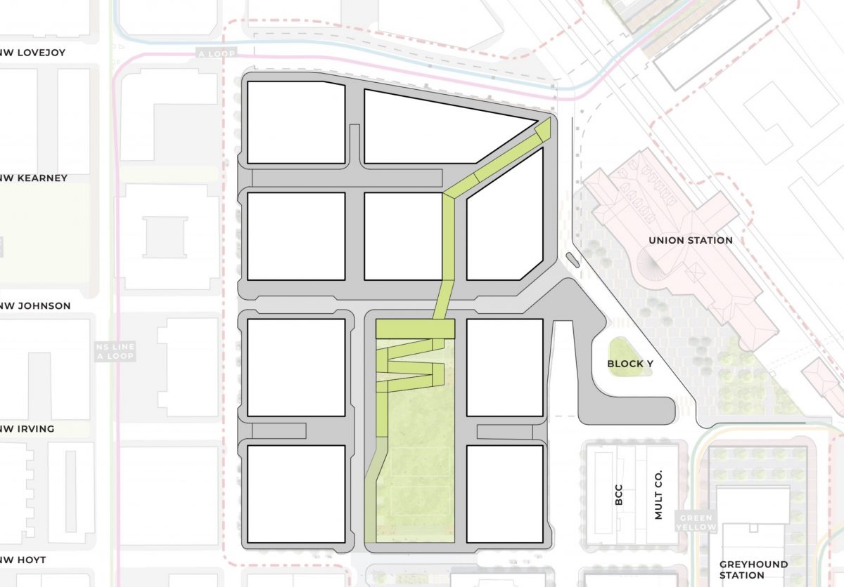
The Green Loop — a project to create a carfree pathway around the central city — figures into this project because the alignment of the path goes right through it. The drawings released today offer us brand new details about how the Green Loop will be designed through the Broadway Corridor site — including an 83-foot long bridge that would go over NW Johnson Street.
Here’s a description from ZGF:
“The Green Loop will approach the USPS site from the south along the North Park Blocks, gradually climbing at the north end of the central open space to a bridge crossing of Johnson Street. North of Johnson, the Green Loop continues as an elevated bridge to the intersection of the Lovejoy and Broadway Bridge ramps. The ramp will be integrated with landscape and an active retail facility, providing a significant placemaking opportunity.”
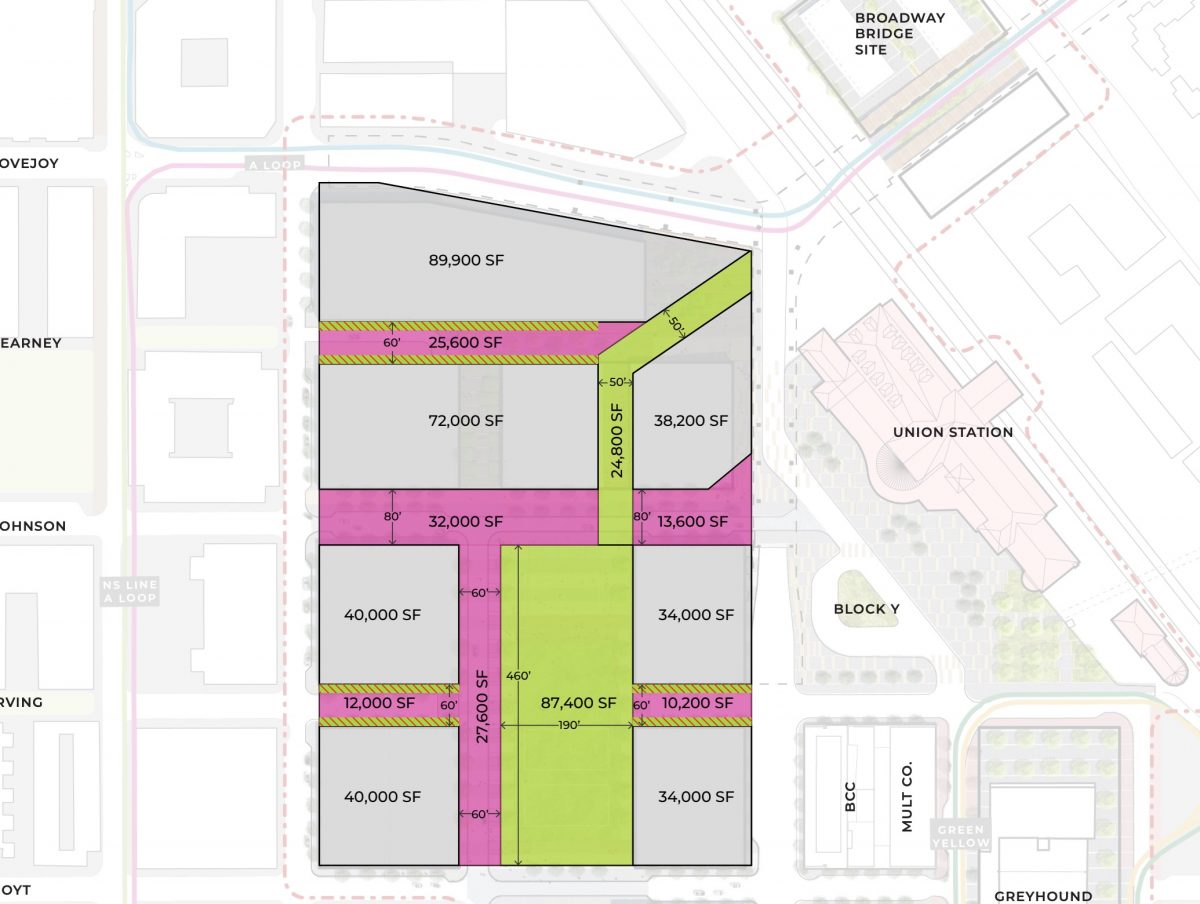
The drawing below shows elevation (in pink) and dimensions (in black):
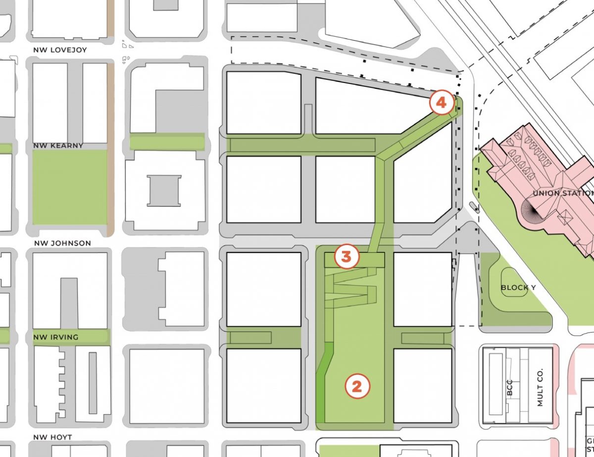
The green-and-pink striped lines are “bicycle and pedestrian access ways” which will help people access the Green Loop from surface streets:
Advertisement
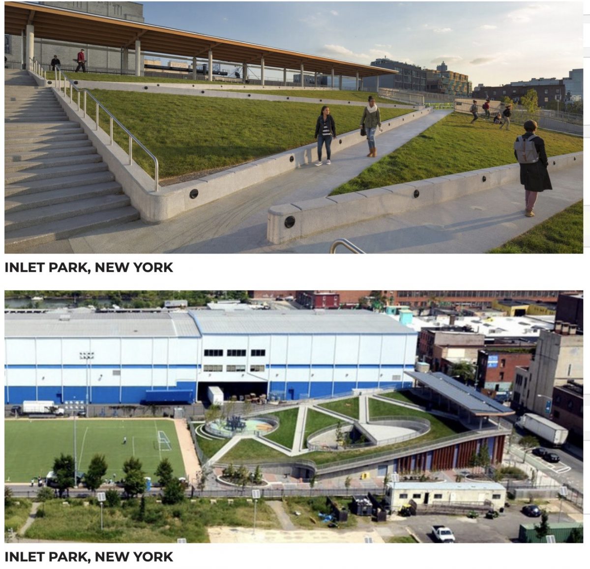
ZGF shared these images as examples of the design of the path and adjacent landscape:
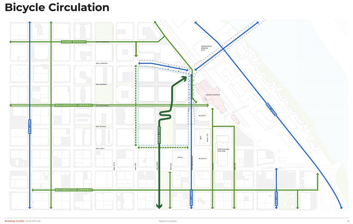
In the “Bicycle Circulation” drawing below, note the NW Johnson neighborhood greenway and how the Green Loop connects directly to North Park Blocks:
The sketch below shows a view looking north at the future site. Note how the ramp would take you from NW 9th, through the site and onto the bridge:

Here’s what ZGF added to give context to the drawing above:
“The preferred concept brings the existing two-way Park Avenue north from Hoyt Street to Johnson Street, helping to connect the North Park Blocks to the Johnson Street Neighborhood Greenway… The street will have active ground floors of buildings at its western edge, with a pedestrian focused woonerf street serving one lane in each direction. At the east edge of the street, the Green Loop will transition from Park Avenue to the Park Block, where it will climb north and up over Johnson Street on a landscaped switchback ramp. The adjacent park block is intended to be open and flexible, to accommodate a wide range of programmed and informal community gathering and recreation.”
Prosper Portland expects the first phase of development for this site (which will be housing, with retail in phase two) to begin in 2021. The Portland Bureau of Transportation is currently doing a transportation impact study on the site which we hope to share once it’s ready.
To download the full ZGF presentation, click here.
— Jonathan Maus: (503) 706-8804, @jonathan_maus on Twitter and jonathan@bikeportland.org
Never miss a story. Sign-up for the daily BP Headlines email.
BikePortland needs your support.



Thanks for reading.
BikePortland has served this community with independent community journalism since 2005. We rely on subscriptions from readers like you to survive. Your financial support is vital in keeping this valuable resource alive and well.
Please subscribe today to strengthen and expand our work.
Wow. ZGF seems really committed to making cycling to and from N/NE Portland as difficult as possible. Is there anything less efficient on a major multimodal pathway than a series of switchbacks? Back to the drawing board, ZGF.
And note that the connection to the south is on Park, which is one-way northbound only, has numerous stop signs, unprotected major street crossings, and does not continue south of Burnside. Broadway is the through street – give us a safe, contiguous bike lane on Broadway and call it done.
I think it works really well on the Esplanade, just like pedestrian bridge elevators. /s
There’s 30′ of height to be gained. The use of switchbacks means that climb can begin further north, instead of starting at Hoyt.
For those who want an efficient (read: fast) route there will still be the existing bike lanes on NW Broadway and Lovejoy.
an architect payed by developers defends the plans of developers. also, water is wet.
I have no involvement with this project.
I’m sorry that for you my years of education and experience are a reason to discount what I’m saying. I notice you didn’t have a substantive response, so just went straight to insulting me.
Soren, go ahead a sketch up a ramp plan that meets ADA and doesn’t have switchbacks. We’ll wait.
Or maybe a sweeping “J” or “U” shape.
i have it on good authority that no other city has ever solved the problem of a modest 30 foot elevation gain without employing switchbacks:
https://www.theguardian.com/cities/2014/jul/14/bike-lanes-bridge-copenhagen-new-cycle-snake-cykelslangen
The height distance Cykelslangen has to make up between Havneholmen and Fisketorvet is 5.5 metres, or roughly 18′. It does that on a path that is 230 metres long, or 755′. (http://www.dw.dk/cykelslangen-bicycle-snake)
The green loop at the Broadway corridor site has to gain 30′ from the Park Blocks to the Broadway Bridge Y. The straight line diagonal from the corner of future NW Park and Irving to the Y is 720′. Denmark might use the metric system, but math works the same way. In order to achieve the same grades as Cykelslangen they need to extend the path somehow, whether by using switchbacks or placing the landing considerably further south.
The switchbacks on the east side of the Steel bridge are too tight for me to navigate pulling a trailer. A spiral (with a looser turn than the Morrison one) would be much easier for big rigs like mine.
I guess this Green Loop is a new downtown route? My naïve belief was that we were getting a flatter, off-street alternative that roughly shadows Broadway and its viaducts on the westside.
To pitch my own idea, all bike traffic would be routed to a freestanding path that weaves through the parcel to the NE corner. Besides reducing the pitch of the climb/descent, you could bring street level all the way up to the bridge by lining it with public and retail spaces. Attaching them as they are built with gangways would make the design flexible look pretty cool IMO.
I bet those ramps have something to do with keeping it from being too steep. Bicycle riders will not be the only people on that structure. Some will have wheelchairs and such. Just sayin’
Inlet Park does not look like a great bike facility, and probably isn’t a design we should be striving towards.
They should include a giant ramp that starts far enough south that no switchbacks are needed. Obviously. Anything else is ridiculous and should be dismissed out of hand. Design the other elements around that need.
Are you being serious?
I wouldn’t say this is obvious. The further south the ramp starts the less time the green loop spends in the Park Blocks. It also makes connections to the NW Johnson greenway trickier.
There’s also the issue of where you put a ramp that long on the site, and how you ensure it doesn’t create a barrier for views and east-west pedestrian traffic through the site.
I’m not saying that their current solution (which is *very* conceptual at this stage) is the only possible one, just that there are good reasons why starting the ramp further north makes sense.
Likewise, there are good reasons why switchbacks don’t.
Did you have a point there, Soren?
It’s disappointing to see someone on the Bicycle Advisory Committee throwing shade on folk who desire efficient and/or fast routes.
I’m not throwing shade on anyone. I really don’t know why you’ve decided to pick a fight with me.
Starting further south requires that you either close Hoyt Street or get the path elevated enough to provide adequate clearance above the street. That means starting the ramp even further south.
Engineers have to think in three dimensions.
The only firm that should be designing this is one from a bike friendly country in Europe. Anyone here is simply reinventing the wheel from their own car biased brain.
If they make the turnouts much bigger than pictured I think it could work. It might even be fun. If it looks anything like the plan view or the example photos it will be a disaster. Could you imagine a pod of 30 cyclists going through those? How about someone with a bakfiet or tandam?
Clarification is needed around the NW Johnson connection here. Johnson travels underneath the bridge at the end of the ramps and switchbacks proposed here. It is not a direct connection. If built as proposed, it will connect via NW Park Ave and the North Park Blocks on the southern approach. From Johnson greenway, a person using a bike could turn onto what would be an extension of Park Ave and she would then turn left at Irving to begin the climb onto the switchbacks. That raises questions.
Is the Park Ave build out within the existing USPS site a park multiuse path or is it a public roadway? The first image implies a roadway with curb extensions and on street parking (perhaps cafe seating and bike corrals). If a roadway, will it be restricted to cars?
Can we just Highline this beast! Totally cap PNCA’s parking lot, give them some covered parking for free, do some wiggles(instead of total switchbacks and make a landing for the north/south path on the actual park blocks south of glisan. Heck lets keep part of the elevated path going and get it past Burnside. From there make Park Ave a bike/pedestrian only allows some truck loading/unloading capabilities utilizing telescoping bollards for the stretch between Burnside and Salmon. That would be a visionary change that still allows for major arterials like burnside to function for motorized traffic.
The people who designed those switchbacks must not be bike riders. They are awkward and difficult to ride. The only advantage they have besides saving space is that they limit the speed of downhill riders, which is good for a mixed-user ramp like this one.
Make a longer ramp with gentle curves. Surely an imaginative architect can come up with a graceful, usable design integrated with the rest of the development.
I attended the Broadway Corridor open house this evening, and complained about the switchbacks. The woman I spoke to said the switchbacks gain about 16 feet of height. In my comments, I suggested putting in either a circular playground or a small amphitheater, and having the path loop around it as it climbed. It would be much easier to handle than the switchback concept, and might be a better use of park space.
Now that most of the PO building is gone, 4 years later, how about an update?