
We hope you did your homework and read our latest charter reform story yesterday, because today Portland’s Independent Districting Commission (IDC) released its Draft District Plan Report. The document shows the three official draft districting maps that will aid the city in deciding geographic boundaries for the new City Council districts. It is with these districts that Portlanders will vote for 12 new commissioners in the November 2024 election and the new districts will go into effect January 1, 2025.
The maps are named Alder, Cedar and Maple. Below are the official maps and a brief explanation of each one:
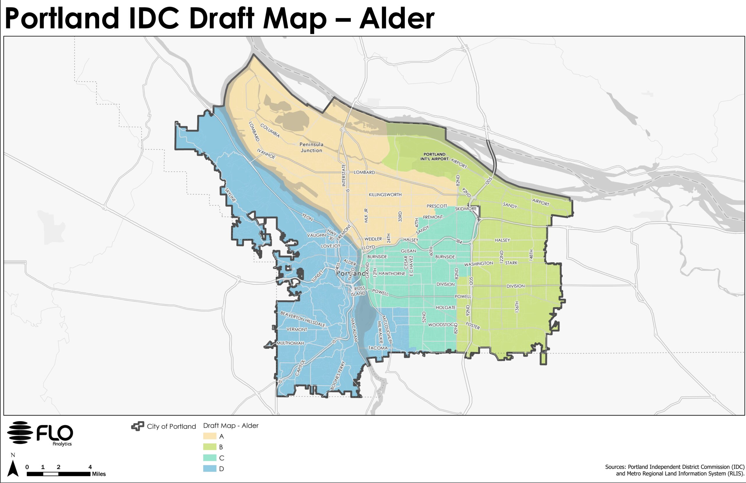
The Alder map is built around preserving established neighborhood boundaries. This map divides the central city among three districts, using the Willamette River and I-84 as boundaries, to promote broad engagement with central city issues and economic opportunities and distribute significant assets and institutions among multiple districts. Neighborhoods in lower southeast share a district with demographically and socioeconomically similar communities on the west side of the river and are connected by the Sellwood and Ross Island bridges.

The Cedar map is built around prioritizing transit corridors.This map uses transit corridors such as NE Sandy, SE 12th Ave, 82nd, and MAX lines to prioritize the role of these arterial roadways in influencing the use of public space and notions of neighborhood on the eastern side of the city. Neighborhoods in the central eastside and inner southeast that are bordered by the Willamette to the west and major transit lines to the east (bus and MAX) share a district with neighborhoods on the west side of the river.

The Maple map is built around keeping much of the central city together, as defined by the city’s Central City 2035 Plan, while preserving historic Albina and adding several inner eastside neighborhoods. The central ci ty includes the city’s most densely populated and urbanized neighborhoods, where residential and commercial uses are tightly interwoven. Eastside neighborhoods with high percentages of renters (Central Eastside, Buckman, Kerns) share a district with westside renter-heavy neighborhoods (Goose Hollow, Old Town, University, South Waterfront) as well as other westside neighborhoods.
The document also includes summary statistics for each map as well as a list of key differences between them:
Crossing the Willamette River
The Alder map crosses in lower southeast only.
The Cedar map crosses in the central eastside and southeast.
The Maple map crosses in the central eastside onlyBoundary between N/NE and SE/central districts
The Alder map uses neighborhood organization boundaries.
The Cedar map uses Sandy Blvd
The Maple map uses both (Rose City Park is in one district, while Roseway is divided by Sandy Blvd)
Based on extensive community input so far, all of the maps share certain features:
- All communities east of I-205 are in a single district
- The Parkrose, David Douglas, Reynolds, and Centennial school districts (the four non-PPS school districts) are in a single district
- Neighborhoods along the northern part of Portland are in a single district, with the exception of neighborhoods in the Parkrose school district
- The north and south sides of Columbia Boulevard are in a single district
- Historic Albina in N/NE Portland is preserved in a single district
- All communities west of the Willamette River are in a single district
- The western border of the easternmost district runs along I-205 and 82nd to accommodate the Jade District and Lents neighborhood
The committee seeks and responds to community input. The report lists eight upcoming public meetings, as well as an email address where you can submit comments. Learn more at the District Commission’s website.

")

Thanks for reading.
BikePortland has served this community with independent community journalism since 2005. We rely on subscriptions from readers like you to survive. Your financial support is vital in keeping this valuable resource alive and well.
Please subscribe today to strengthen and expand our work.
Surely this is a cruel joke right? I mean I love the #70 far more than the next guy but saying a bus that runs like 30 to 35 times a day (at ~20 to 40 minute headways, stopping before 8 pm on weekends) and doesn’t even run on SE 12th Ave between Hawthorne and Powell anymore qualifies as a transit corridor is a bit of a stretch. MLK/Grand is the clear N/S transit corridor through the central eastside with roughly 3x the service.
If they wanted to reference how SE 12th was a transit corridor and how it influenced development patterns that roughly define neighborhoods these days – fine. But really hard to take a government commission seriously that doesn’t even know where a transit corridor is.
Otherwise, I think the Maple map is probably the best. Having lived in Buckman previously and Brooklyn currently, I’d say the central eastside/Buckman area has more in common with the central city/west side than Sellwood and Brooklyn do.
I live in Brooklyn as well and prefer Alder. Sellwood being connected to the west side makes sense. It also does a better job of keeping Cully in one district. Roseway and Rose City Park in the same district makes sense.
As a Sellwoodie I initially thought Maple makes more sense culturally — but it does make sense from a practical standpoint. A lot of westsiders do most of their business here, in fact that’s what drew us here from SW
Am I m,issing something, or has this committee completely misundertood transit? They say
But then they use those corridors as dividing lines. This splits the catchment area of those transit lines and divides the power/interest into separate districts. Surely a district the prioritizes a transit corridor would extend 1/4-1/2 mile minimum on either side of the corridor, right? I think the Cedar Map will accomplish the exact opposite of what they claim to be trying to achieve
I’d say the committee completely misunderstands transit. The boundaries noted in the map there are all fairly obvious boundaries – but not really because of the transit services. NE Sandy is a fast, wide street. 82nd is a fast, wide street. The MAX lines in question (Orange/205 pieces) were very hard boundaries before the MAX came in (the UPRR mainline and 205 respectively). SE 12th hasn’t been a primary transit corridor since the Powell underpass was built in 1972.
Especially considering the amount of transit on SE 12th (not much) compared to MLK/Grand (a fair amount) a few blocks away it seems like they came up with the boundaries and tried to slap an explanation after the fact.
Hi Blum and Max,
I might be able to clear up a little regarding the Cedar Map, or what during the meeting was known as Map 10.
I did not get the impression that the person who drew that map had a familiarity with Portland’s transportation policy or goals. Rather, he was suspicious of neighborhood association boundaries, and reached instead for urban arterials and other transportation barriers as an “intuitive” way to distinguish districts.
A YouTube of the meeting is available here:
https://www.youtube.com/watch?v=iDCJWztsCWw
The presentation of the Cedar/Map 10 begins a little after minute 54. Here is my transcript of a portion of the presenter’s rationale behind his map boundaries:
So, in other words, “I don’t understand these boundaries that are so important to Portlanders, and I would love to learn more, but instead I’m going to ignore them.”
None of the maps perfectly preserve all neighborhood boundaries. They make a great point that a lot of neighborhood boundaries are pretty random. And while 12th might not be a major bus route, it is an arterial that divides the industrial and residential zoning (you can clearly see the divide in satellite view). Makes more sense to draw a line along a visible difference then arbitrary neighborhood boundaries.
NA boundaries aren’t arbitrary to people who live here.
Thanks Lisa. That was interesting to listen to. I like how he describes wanting to create river district by centering the river. I still do not see how using a transit line/max line as a boundary prioritizes transit. I think these resources would be better served by centering them within a district.
FWIW, I added this comment to the survey: Your use of barriers as boundaries will serve to further cement that barrier forever. I saw a map (Cedar) claiming to “prioritize transit”, but it used transit lines and arterials as boundaries. This splits the ridership catchment area and greatly weakens advocacy for improvement. Highways, the Willamette River, and transit lines can be thought of as having opportunities for connection. If the river or a highway or 82nd Ave is centered within a district, there is a community motivated to push for better connections and improvement. However, if those become boundaries, the communities who would naturally advocate for creating connections are split into 2 districts and their voice/message is diluted and likely lost among other priorities. Please consider centering some of the barriers within our city within districts so our future is better set up to create more connections.
Almost all neighborhood association boundaries are divided by major roads and the river. Even neighborhood coalitions generally follow this trend. I’m not sure if it’s possible to not use those as boundaries without making a lot of people unhappy for splitting up neighborhoods into different districts.
That’s not true.
The specific issue between the maps is whether/how to use Sandy Blvd as a district boundary. Sandy cuts through about six different neighborhood boundaries. It is not currently used as a neighborhood boundary at all.
At the top of the post I link to individual Alder, Maple, Cedar maps as they appear in the Distrct tool. Go to the Data Layers and load up NA boundaries. You can see exactly where the NA boundaries lie, and they are not always on major streets.
Yes it is. All the highways, 84, 205, i5 and even Powell all cut in between neighborhoods except for a select few neighborhoods like Lents. Not to mention not a single neighborhood crosses the river.
I was responding to maxDs comment “Highways, the Willamette River, and transit lines can be thought of as having opportunities for connection” and countering that idea that these boundaries already exist and divide NAs. To ignore highway and river boundaries would be to be ignore a lot of NA boundaries.
“Neighborhoods along the northern part of Portland are in a single district, with the exception of neighborhoods in the Parkrose school district”. One issue here is that the yellow district also includes Irvington, Dolph Park, Grant Park, Alameda, Beaumont / Wilshire and a few other areas that likely have a much higher voter turnout than N. Portland, AND have vastly different demographics / income profiles.
Agreed, that was the first thing I noticed too.
If I can do ranked choice:
1. Something that has 5-6 districts based on the cardinal directions, doesn’t count the airport or ports as land in the district (they are governed differently and it gives the impression of large territory when it really isn’t.)
4. Cedar
5. Alder
7. Maple
In the city that does not work, implementation of these new districts is likely to be “interesting”.
The big decision I will have to make in 2024 will be whether I remain unregistered (voting in an oligarchy is immoral) or vote for some innocuous person that will never be in the top 6 in order to mock this flawed voting system (discarded votes, intentional lack of proportionality).
If you want to make the biggest statement, voting for folks below the top 6 is the way to do it.
First of all, I expect some positions won’t have 6 candidates. Secondly, it will often be difficult to predict who wins that 3rd position because 25% of whatever votes have not been used or discarded may represent a small percentage of total voters. And finally, I suspect we will see a large percentage of voters who do not fully rank candidates, which will be hilarious.
You can thank “Communities of Color”
and the nonprofit and government workers (mostly of the far left persuasion) on the Charter Commission for bringing us a system where votes will be discarded and the majority of citizens will be unable to comprehend a complex voting scheme (single transferrable vote with multi member districts). I don’t understand it and neither do most of the people that brought it to us.
I vehemently disagree. I think that any genuine democratic process should over-represent minority voices to prevent capture of the electoral process by a bad-faith majority. Electoral systems in the USA typically merge the worst aspects of oligarchy (duopoly) with the inherent authoritarianism of majoritarianism.
Man, you must love the US Senate.
The question then becomes how to define a minority. Are you willing to define it by income, by something as crude as skin color, sexual mores, gender, gender identity and the list goes on. Just because I look like someone else generically does not mean I think like them. I don’t like the idea of lumping people together based on some random characteristic expecting that they think alike or have the same needs or wants.
I understand why people think that “minority” means something racial or ethnic, after all, that is what the census tracks and therefore those are the statistics available for mathematical modelling.
But my favorite minority is “Portlanders-who-care-about-active-transportation.” It’s a significant minority. Maybe it is a actually majority but they don’t realize that about themselves yet.
They ride bikes, walk, and are allies of groups like the Street Trust, Oregon Walks, Bike Loud, No More Freeways, and others. This minority has a deep bench of possible candidates who are not defined geographically. They can run candidates in all four districts. They can gain representation on the city council.
To fully appreciate how multi-member districts might change the Portland political dynamic it helps not to use the most limited definition of “minority.”
My great finger crossed hope for the new district system is that it will give at least one person room to run unapologetically as pro active transportation. To not have active multimodal transportation as a mi ir part of their plan that they mention time to time, but their whole plan which they can discuss as being able to solve the City’s ills. I certainly hope that this deep bench of candidates can be convinced to run, because I certainly haven’t seen it happen yet.
“Maybe it is a actually majority”
You may be right, when the issue is considered in the abstract. But I am highly doubtful that any transportation plan that makes driving significantly harder would gather support by more that a small-to-medium minority.
I agree that making driving harder won’t get much support. What needs to happen is that active and public transportation becoming enticing enough to draw those who prefer to drive, but don’t really need to out of their vehicles (whether they are ICE or EV). I personally don’t want to make driving harder, I prefer the carrot. I also acknowledge that the funding which would include CONTINUAL MAINTENANCE is beyond Trimet at the moment and most likely into the future. Clearly it is time to do away with Trimet with how it is organized now as well as get rid Metro Governance completely.
And this just isn’t going to happen given how incredibly convenient and easy driving is. Every single region that has shed its car-dependency made it hard to drive. Until the USA starts to care about traffic violence and ecocide I expect nothing will change.
I don’t believe that transit as we currently understand it can compete with driving outside of a selected set of circumstances or a small number of people in a city like Portland.
The revealed preference data supports this view.
Or to put it another way, sustainable, tempered consumption can never compete with maximum consumption.
So it has always been and always will be, until it can’t.
TriMet’s answer this has been to try to create an alternate transportation system to replace car commute trips. They have not tried to become an alternative source of transportation. It is interesting to imagine a transit system designed to replace cars. It would need to be much denser and more flexible, go to many, many more places including recreational destinations, overlap with other transit/transportation option, be more flexible about who/what gets on board- pets, bikes, ikea/costco hauls, chickens? and be more convenient- frequent, 24 hour, and operate in inclement weather.
Generally, I’m in agreement with this sentiment – transit needs to be better and more targeted to today’s, not yesteryear’s, use-cases, but careful: You’ve baked some of that maximum consumption into your car replacement requirements. The consumption is more about lifestyle choices, rather than mode of transportation – the idea that one should be able to go everywhere in a metro area, point-to-point, anytime, with anything, and very little personal energy expenditure is already a very expensive starting point.
That’s a good point! I was thinking of how transit would need to evolve to provide a replacement alternative to cars, but I think your point is that the expectation of car owners is not sustainable and should be re-imagined! I agree that should be the long-term goal that we base our planning and policies on. Short-term- there could be some tweaks to the system like letting people travel with more stuff (pets, boxes, etc), more frequent headways, and extended weekend/nighttime hours that would make transit a more viable alternative.
I think many who love active transportation (biking, walking, etc) and want more safe ways to do it, do NOT support the tactics of the local transportation advocates (Oregon Walks, Street Trust, Bike Loud, etc). Once they called for less police and closing all major Portland arterials to vehicles I was done with them. It’s unfortunate but they have loss many supporters due to their drift to the extreme.
I’m not talking about identitarian politics but about creating inherent guardrails so that majority parties (say the corporate-fascist red-blue duopoly) cannot not create electoral processes/rules that permanently exclude other political tendencies. I think the vast majority of people in the USA are in complete denial of how un-democratic our voting systems are. (And by voting systems, I also mean campaign financing and the grossly oligarchical “captured” media.)
Don’t include me in your race and religion culture war, Randi J.
See: https://bikeportland.org/2023/06/02/here-are-the-maps-that-will-help-decide-portlands-new-city-council-districts-375760#comment-7497471
Single Transferable Vote is proportional, that’s the whole reason it was invented. It can’t be perfectly proportional–the only that would is direct democracy–but it’s a massive improvement over the system it’s replacing.
Discarded votes will almost certainly be a huge problem for the ridiculous implementation of STV in PDX given the lack of motivation of the bulk of the amerikanski electorate . I don’t really give a @#$% because I have not voted for a while and will likely not vote in 2024 but the wishful thinking of people who are too afraid to actually face the brutal oligarchy that runs this country provides me with an awful lot of schadenfreude.
Ah but STV with multi member districts is a different animal. That’s why it’s only been tried in a few places. I’m bummed we’re an experiment again.
STV is inherently a multi-winner system. Quite the same animal, in fact.
I like the Maple map. I prefer to avoid splitting neighborhoods when possible, and Maple splits three of them (Roseway, Montavilla, and Hosford-Abernathy) that I noticed. But those splits are fairly logical and lead to population balance. Putting the Central Eastside together with downtown makes a fair amount of sense given the number of east-west connections from the Burnside to Ross Island Bridges.
Pretty impressive but I’m a little disappointed none of the truly creative maps made the cut (like the ones that gave every district a finger into downtown/central eastside)
Of these three I would veto Cedar out of hand. It seems to conflate “transit corridor” with “busy street.” It also turns shared assets (streets) into boundaries. Two addresses across from each other on Sandy — constituents who are neighbors and should be aligning on common concerns — are now going to have to write letters to councilmembers in two districts, half of whom are not the ones they can vote out