
Portland’s Independent Districting Commission (IDC) has selected three draft maps of potential City Council voting districts to present to the public. These are the maps that will set new geographic boundaries for the four city council districts under the new form of government and will be in effect for the November, 2024 election.
At a three-hour work session Wednesday night, each plan was presented by a sponsoring commissioner who then fielded questions from the other commissioners. The group could choose to present one or more maps to the public in a series of meetings to be held in July, and ended up deciding to put forward all three.
Last night’s meeting was far from perfunctory. The usual Portland political tensions, such as how or whether to honor established neighborhood boundaries, were given voice by several committee members. The group was ably guided by the facilitator and the decision to forward all three maps came in a close 8-5 vote.

The 13-member, volunteer commission was appointed by Mayor Wheeler from a pool of 282 applicants and approved by the City Council at the end of January. They have spent the past four months immersed in the nuances of drawing districts, and face a deadline of September 1st to present a final, publicly-vetted draft map to City Council. If a super-majority of nine of the 13 commissioners approve the final draft map, it will go into effect. Otherwise, it goes to City Council for a vote.
Before the September deadline, the committee will hold at least two public hearings in each proposed district, for a total of eight public meetings.
The committee intends to publish the draft maps on Friday (6/2), and the plan is to annotate them with notes explaining the reasoning behind their boundaries, and to include some discussion from last night’s meeting. Several committee members expressed concern that without background and explanatory text the public might not be aware of the criteria required for drawing districts or the issues the various boundaries address.
The Commission
The commission itself is an impressive and highly qualified group of people. I felt like I was watching the Tour de France of Zoom meetings. The IDC is one of three committees described by last fall’s charter reform amendment to transition Portland from its current century-old commission form of government to a system of geographic district representation.
Portlanders can be confident that this group has taken seriously their historic responsibility to draw the boundaries of the city’s first geographic districts.
The vote on which maps to present to the public came at the end of an arduous meeting in which commissioners made clear that they had grappled with the intricacies of ensuring fair representation in Portland. Here are some of the issues that the commission has considered.
What makes districting in Portland unique
There is no perfect map.
– Members of the Independent Districting Commission
Several commission members had attended an information session about districting presented jointly by the North Star Civic Foundation and Common Cause earlier this month, in which two districting experts shared their experiences from Los Angeles and the Bay area. The idea of city assets figured largely in that conversation, and it was an aspect of drawing districts that I, and perhaps some commissioners, hadn’t considered before: distribution of assets.
Distribution of assets
What is a city asset? It can be an institution, like museums, universities, zoos, sports venues, parks. But it can also be a location. One fun example from LA was the route of the Rose Bowl parade, which offered city councilors representing those districts a high-profile opportunity to appear before the public, waving from a float.
The gist was that having city assets in one’s district brings visibility, power and connections to a representative. Designing districts so that assets are distributed somewhat evenly between representatives fosters cooperation and collaboration.
The North Star/Common Cause information session made a lot of sense, but there were limits to its relevance to Portland. A reality of our city is that most assets are concentrated west of the Willamette River: the largest universities, the art museum, the big concert and theater venues, biggest park, biggest employer, zoo, civic stadium, central library. The distribution of assets in our city is lopsided.
This becomes particularly relevant when deciding which section east of the Willamette should be joined to a west side district to reach required population parity between districts (the west side does not have a large enough population to comprise a single district without an area from the east side joining it). The concern is that “asset-packing” in a single district might bring advantages to the representatives of a particular district.
The difficulty is that the close-in, east-side-of-the-river areas are also asset-rich. Moreover, some neighborhoods, like St. Johns apparently, really don’t want to join the west side.
A largely white city
Portland is one of the whitest cities in the United States and, with the exception of the Asian population, the city’s people of color (POC) are distributed somewhat evenly throughout the city. We don’t have highly ethnic enclaves.
The ranked choice voting in multi-member districts method itself is an attempt to bring fair, proportional representation to people and views which cannot be corralled into a particular geographic location. It is not possible in Portland to create a majority minority district. Because of this, many people repeatedly lose their voice in our current at-large voting system.
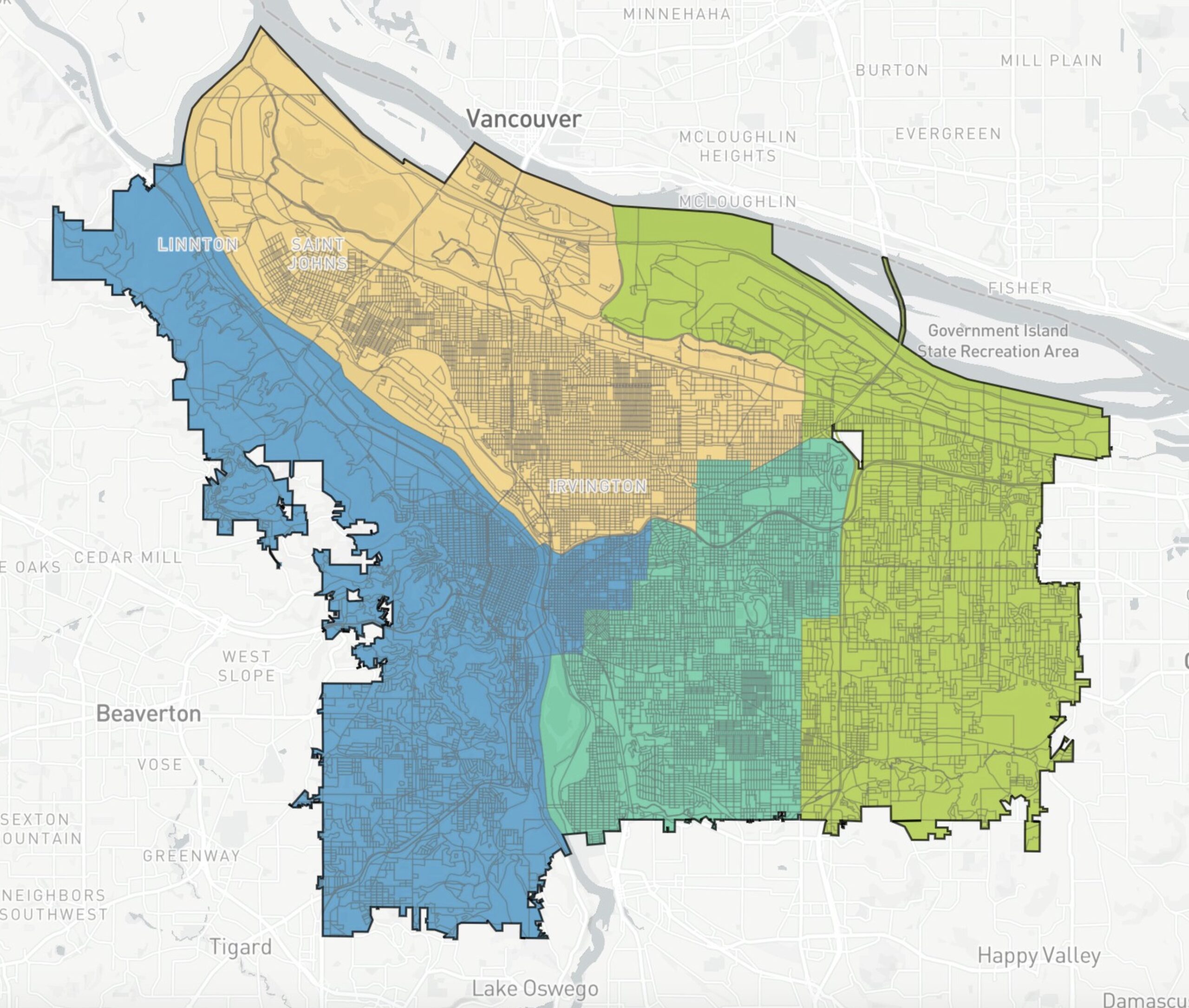
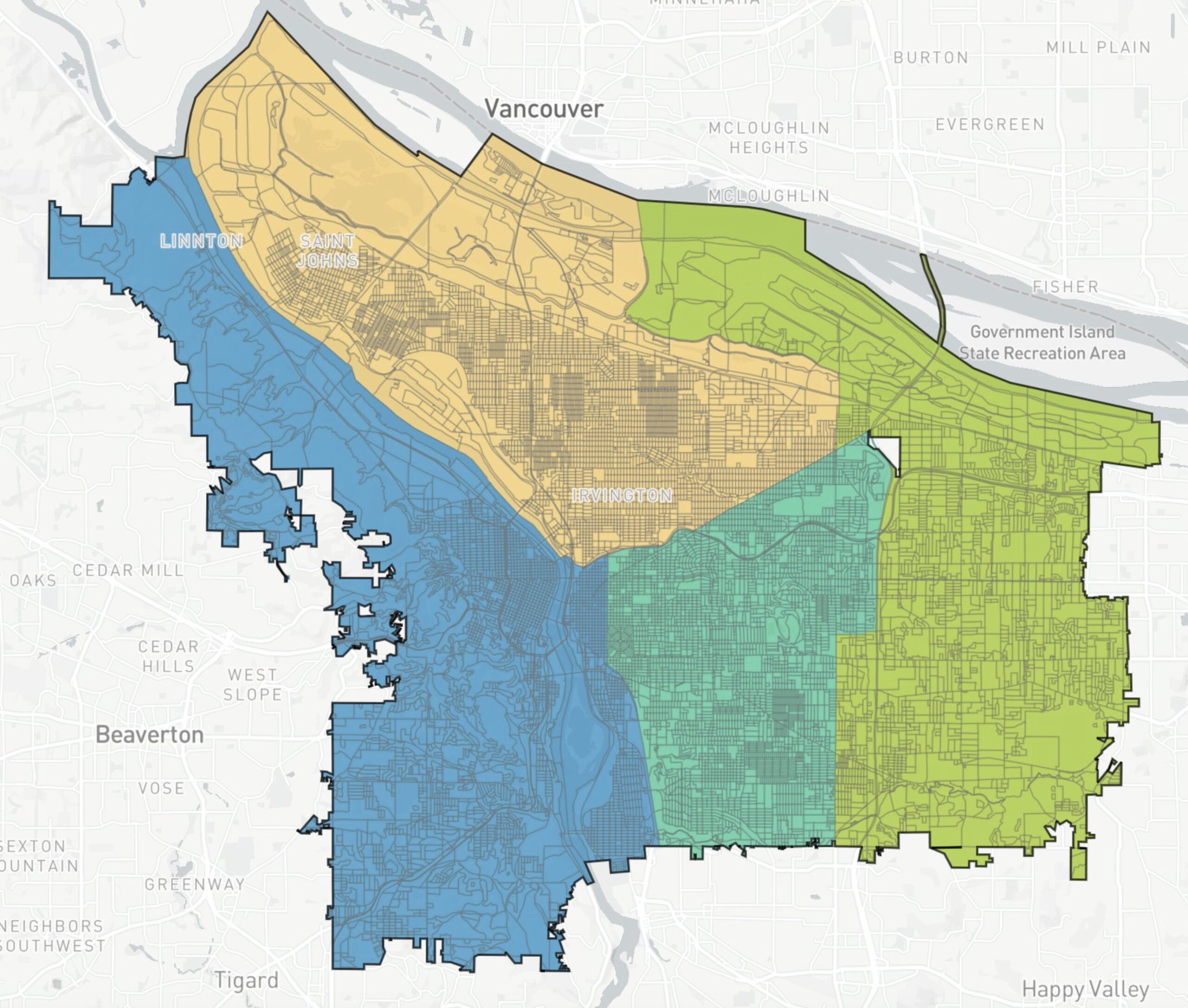
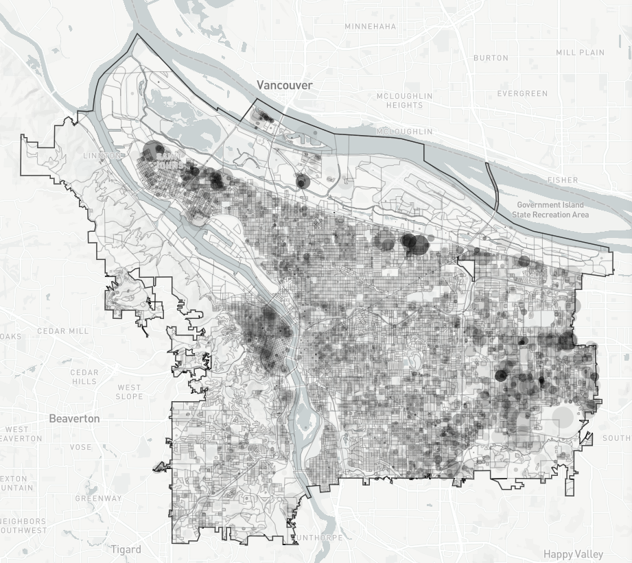
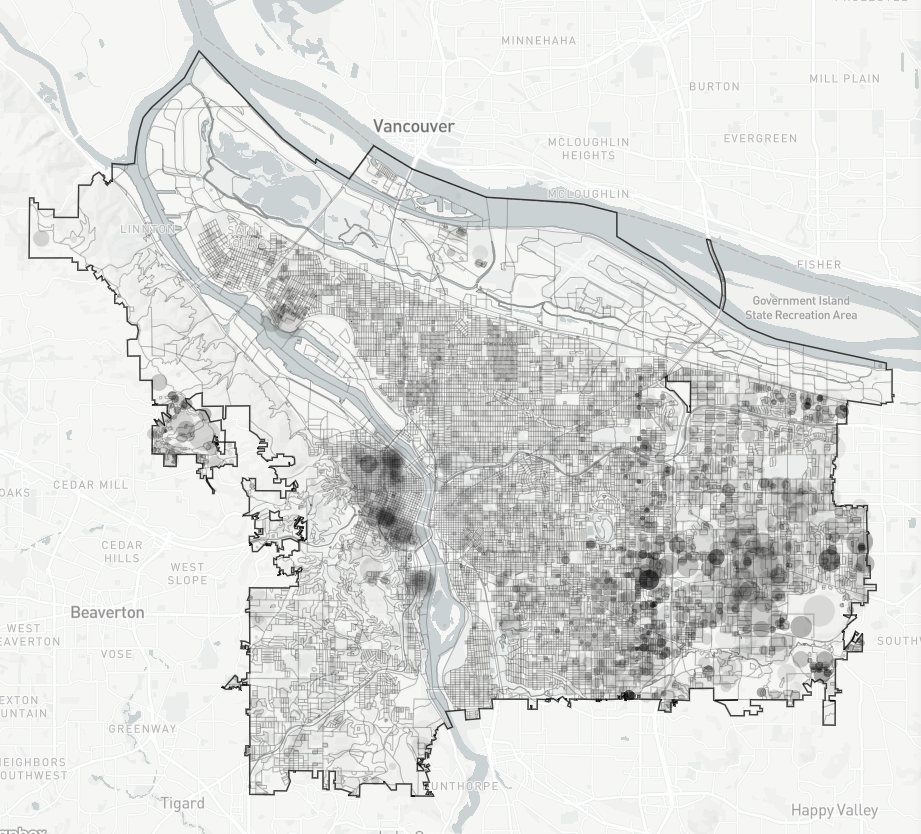
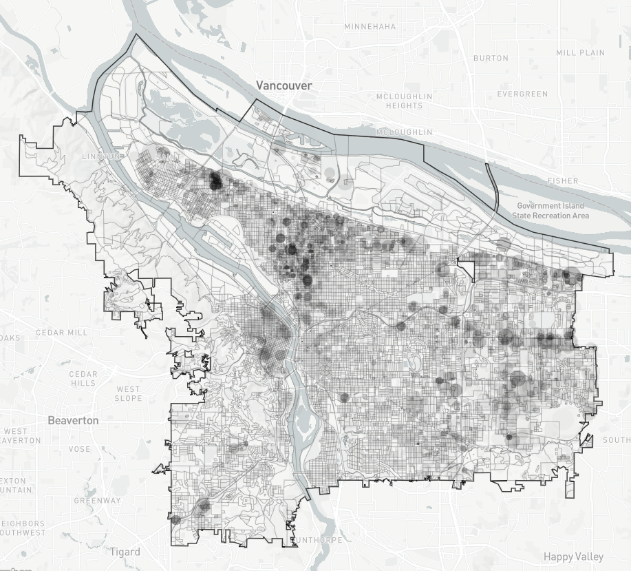
For example, these maps from the DistrctR tool (which is being used by the IDC) show
1) the distribution of the 11% of the Portlanders who identify as Hispanic. As you can see, there isn’t a single Hispanic neighborhood, the population is distributed throughout the city.
2) The Black population at 5.7% is, to a lesser extent, also spread throughout the city.
3) The 8% Asian population is more concentrated east of E 82nd St, and also in downtown.
These distributions led to discussions last night about which neighborhoods should or shouldn’t be divided between separate city council districts. A lot of time was spent talking about what is called the Jade district, an area in east Portland with a high concentration of Asian businesses.
One commissioner mentioned that he had been in contact with APANO (Asian Pacific American Network of Oregon) and Duncan Hwang (Metro Councilor and Community Development Director of APANO), and had learned that, counter-intuitively, the Jade Business district leaders were fine with being split across two districts. The rationale being that it would give the community the ear of six, rather than just three, city council representatives.
Geographic barriers, population and culture
All of those concerns layer on top of the history and geography of the city. The main reason there is not more of a concentrated Black neighborhood is because residents of lower Albina were displaced by: the alignment of Interstate 5 through the heart of their neighborhood; the destruction of housing due to planned Legacy-Emmanuel Hospital expansion and; the construction of Lloyd Center. That destruction was followed by years of gentrification.
Geographically, the river is a natural boundary, but the population west of it is not large enough to be a district on its own. The river is also a political/cultural boundary, with one of the few resentments still socially acceptable to publicly express being animosity toward the west side. So it is understandable that some eastsiders are not eager to join a largely westside district.
What the IDC needs from you
Several commissioners repeated the phrase that “there is no perfect map” and emphasized that the draft maps were a starting point for further discussion. Borders can be tweaked, and the Commission seeks public feedback. Many times during last night’s meeting commissioners recognized that they needed to find out what people think, that the IDC doesn’t have all the answers.
That’s where you come in. Find a July meeting, fool around with DistrctR, write a letter. The draft maps should be released tomorrow, and most likely the IDC will begin receiving a torrent of advice. Stay tuned for a follow-up.
")


Thanks for reading.
BikePortland has served this community with independent community journalism since 2005. We rely on subscriptions from readers like you to survive. Your financial support is vital in keeping this valuable resource alive and well.
Please subscribe today to strengthen and expand our work.
Moving to Maywood Park!
No camping!
Best bike path!
It really is the only part of the Portland Metro area where you can low-stress ride your bike to go mountain biking. Just take the 205 MUP up to Gateway Green.
Lisa,
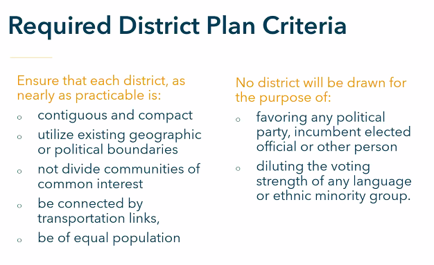
I think you should make it clear it’s not okay to design districts to advantage one racial group over another. It’s called racial gerrymandering and it’s against federal law.
Marcus, that is included in the District Criteria graphic about mid-post.
That’s not quite what it says Lisa. It says this:
“No district will be drawn for
the purpose of:
diluting the voting strength of any language
or ethnic minority group.“
It ALSO can’t advantage any ethnic minority (or majority ) group. Many of the committee members felt that was their raison d’etre (racial justice via gerrymandering) but were informed at their first meeting that creating districts to advantage a racial group was illegal.
How would you create a district in Portland to advantage any minority group? I don’t see how it is possible. Give it a whirl w DistrctR.
The committee seemed knowledgeable and experienced to me, an impressive group who should be thanked for their hard work.
Maybe you missed the comments by members like Neisha Saxena on why she should be part of this committee:
Setting aside the question of whether it is even possible to advantage a racial group in Portland, that quote doesn’t have anything wrong in it. Undoing racial inequality necessarily gives advantages to one group relative to where they are now. That’s what that means.
Like, say some area had previously been gerrymandered such that a minority group was split up and diluted such that they had no representation. Just hypothetically. Correcting that wrong by, say, making a district that re-united that group would (according to some) give them more power, that’s literally the point. That’s not against any federal law.
You’re using an example that has no bearing on the current situation. There has been no gerrymandering as the current councilors are at large. This is the first drawing of districts, there is nothing to correct.
I thought I made it perfectly clear that this was a hypothetical, not a description of Portland right now, and it is to make the point that it’s not violating any laws to draw districts in a way that helps some racial group.
Having no districts is the same thing as having one big district, and if having everyone in a single district disadvantages some group, lets say by diluting them in one of the whitest cities in the US, then it is entirely reasonable to fix that (if possible) in the new districts.
Like I said, it doesn’t look like that’s really possible in Portland but that’s besides the point. The point is it wouldn’t be somehow violating any federal law to draw districts in a way that happens to right some historical injustice.
Nowhere in that picture does it suggest she intends to advantage or disadvantage any ethnic group. In fact it doesn’t say anything about the type of districts we should draw, other than that it’s import to not reproduce past structural biases, which seems perfectly consistent with both the charter law you quoted above and federal law.
I once tried really really hard to create a majority-minority district in Portland with DistrctR – it was incredibly gerrymandered and snakelike – but the best I could get was 47.5% of a coalition of black, Asian, Hispanic, and all other census minorities. I’m sure if you included immigrant whites from Russia and the Ukraine you might be able to pull it off, but the census doesn’t distinguish them.
Just so you know David that would be against federal law. The funny thing is many on the committee went into the endeavor thinking they could do just that.
Murder and marijuana sales are also illegal under federal law, but like gerrymandering by race, they are all too common in eastern states and poorly enforced.
Fascinating!
It is amazing to me that, given the density of tall buildings, downtown Portland doesn’t have sufficient housing to make up the population difference compared to the east side districts.
It’s kinda too bad that the West side district has to also include voters from the east side. Given that the districts are multi-member, I wonder why the West Side district couldn’t just have fewer councilors, in proportion to the population difference.
Germany has states with varying numbers of upper-house members, with city-states like Hamburg and Bremen with just one each.
It has to do with the US constitution, which requires every congressional district to have roughly the same number of people in those states with more than one district – this principal is then extended to every state legislative and county and city district too, by both law and by custom.
“fewer councilors”
That won’t work because the charter says 4 districts with 3 members each, period.
What would work, however, would be to break up the Westside and have different parts join with different parts of the Eastside. Linton and St John’s, for example, would be a very good fit, as would the SW Hills and the Selwood area. NW has a lot in common with Buckman.
The areas of Southwest with poor drainage are very similar to Pleasant Valley, way on the extreme southeast of the city. I’ve always thought that Lair Hill ought to join forces with the People’s Republic of Argay, in the extreme NE.
Never considered the distribution of assets, great reporting. With the Willamette being such a strong cultural divide, I don’t think any map can work that takes into account both the river divide and the large concentration of amenities.
My two cents is that distribution of assets matters more in a single-member district system, and is one of the major flaws of that system. We only have to look at what happened with the LA City Council on the past year to see the issues with it.
Just left a comment cautioning the Commission against relying too heavily on major roads and highways as geographical boundaries. Seeing I-84 and Sandy relied upon like that threw up yellow flags. The relative lack of access between Madison South and both Gateway and Montavilla is killing me!
I believe that using existing barriers (highways, river, etc) as boundaries will only serve to solidify them as barriers. We have an opportunity to create districts that cross barriers to encourage the creation of better political and physical connections across them.
It looks like 90% of the maps are similar, and the main issues left to decide are which eastside district gets lumped into the westside, and how the boundary around Sandy/82nd/I-84 gets drawn. As a Sellwood resident, I like the first map (left on the above graphic) that keeps Sellwood in a SE district and includes the more intensely developed central eastside area in the westside district.
It’s interesting that St Johns somehow effectively lobbied to NOT be part of the westside–how can other neighborhoods get the same deal??? I don’t know that it makes sense to include St Johns with the westside, but it’s interesting to me that they were able to establish their position as one of the guiding principals for the districting process to keep it from any further consideration.
Another factor that could be considered in developing these districts could the zoning and comprehensive plan maps for these areas: central eastside and Lloyd are both zoned similarly to downtown and may have more similar development patterns and related issues.
Did St Johns lobby to not get included in the west side? The article only mentions that they don’t want to want to be part of the west side with no further details.
In my opinion, St Johns, Sellwood, and Central Eastside all have things in common with areas west of the river but they all have even more in common with the areas next to them east of the river.
A common complaint I hear from St Johns is how disconnected and forgotten it feels from the rest of the city, a similarity a lot of the further west side neighborhoods feel too.
Sellwood, and especially parts of eastmoreland feels a lot like SW neighborhoods at times but is very different than downtown. Central eastside is the opposite where it has more in common with downtown with no relation anywhere else west of the river. It’s pretty much impossible to take the bus from the SW neighborhoods to central eastside without at least one transfer although same could be said the same about getting to Sellwood.
These look pretty close to the best possible options given the constraints. Nice work.
It really makes me wonder how we ended up with only four districts. If the charter review committee really wanted minority representation, they could’ve opted for 6-12 districts where it would be possible to have minority-majority districts, or at the very least, districts with similar development patterns. Then again, just having four districts makes it easier to make a map since there aren’t many ways to deal with the population distribution, as shown by the three very similar options provided. Will be very interesting to see how this all plays out when the first vote is over.
Well it turns out it’s highly illegal to set out to create minority majority districts. Who knew?
why do they meet on zoom and not in person in a downtown government building conference room?
Just maybe because it is easier for the public to listen in, without the public screaming into the faces of the commissioners, like at TriMet board meetings?