I don’t know where the hours went, but it might have had something to do with the new DistrctR tool which is awesome and addictive.
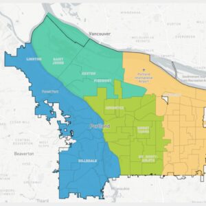
DistrctR is the computer program the Independent District Commission (IDC) is using to draw Portland’s new four-district city council map — and you can join in with your own map too! Everything has been set up so that you can draw a map and have it published on a Portland Community Gallery online. Get in early, there are only eight maps up so far. Here are three of them:
Reed College Political Science Professor Paul Gronke contacted me earlier this week with news of the new version, which is now based on 2020 census data.
“The prior maps relied on 2010 Census data which was, frankly, quite out of date for Portland. In particular, the percentages of Hispanic were substantially lower, and residential patterns have changed quite a bit in the last decade,” Gronke emailed.
Plus, the new version is a whole lot slicker.
The “data layers” page lets you overlay neighborhood and school district boundaries and also precincts (in case you want your map to keep those communities whole). It’s also now based on census blocks, which allows for more granular, refined maps. Gronke tells me that his students are finding it much easier to hit the 163,126 “equal population” sweet spot that four districts requires.
Remember, your districts should:
- be contiguous and compact
- use existing geographic or political boundaries
- not divide communities of common interest
- be connected by transportation links
- be of equal population
The IDC has a page of links to Key Documents some of which which are educational. Their timeline shows that they plan to have a draft district map by June.
DistrctR is the work of the MGGG Redistricting Lab at Tufts University (MGGG stands for Metric Geometry and Gerrymandering Group). MGGG is a non-partisan research organization which contributed to Portland’s Charter Reform effort by modeling Portland voting. FLO Analytics is providing technical expertise to the IDC.
Have fun!


Thanks for reading.
BikePortland has served this community with independent community journalism since 2005. We rely on subscriptions from readers like you to survive. Your financial support is vital in keeping this valuable resource alive and well.
Please subscribe today to strengthen and expand our work.
https://districtr.org/plan/180878
This is the map I’ve come up with after playing around with the tool for a while. It’s weirdly fun! Under this map, all districts are within 1500 people of each other, are compact, and have boundaries along major geographic features, major roads, or rail lines. And I’ve tried my best to avoid splitting up any natural communities, although a few such splits (sorry Parkrose and Alameda) are inevitable to achieve equal-population districts.
Nice work following major roads like 82nd! My only complaint is that it puts me less than a block from the edge of my hypothetical district and cuts me off from those neighbors, but maybe it’s for the best. Particularly interested in the fact that we came up with nearly identical western districts that follow the boundary created by UPRR.
Tried this map with boundaries mostly along exiting transportation boundaries. Split the rest of N/NE and SE along the Banfield/MAX and East Portland along Lombard/NE 82nd/I-205 to arrive at a deviation of only 0.1%.
Keeping more or less the same western district, I tried a similar approach with this map and got down to 0% deviation, with each district all within FOUR people of the so-called ideal! Managed to get N/NE to exactly 163,125 almost entirely along major transportation boundaries.
I suspect my most controversial decision would be the inclusion of St Johns and Kenton in the same district as most of East Portland, but if you’ve ever lived past the cut or north of N Lombard St, you probably already know how far removed from downtown it often feels.
One is the loneliest number; two’s company; three’s a crowd; and four is a seriously awkward number of districts for Portland.
I drew a map that uses neighborhood boundaries, and kept the population deviation just over 2%. I couldn’t preserve entire neighborhood coalitions, though, much as I would have preferred to.
https://districtr.org/plan/180960
I’ve found that SE Uplift and East Portland (EPCO) together have almost exactly the population needed for two districts, so it’s simply a matter of splitting a neighborhood in SE Uplift such as Montevilla to even both out at just over 163,000. The entire west side of the river doesn’t have enough people to constitute a district, so on any scenario one has to spill over into St.John or the Lloyd District.
I think the river should not be a boundary wherever possible. I think it would beneficial to make decisions about industrial, recreation, environmental and transportation decisions where both sides of the river are considered and advocated for holistically rather than in a competitive way. I also think that center the river in a district will help center in discussions and planning discussions
The two options displayed here so far (Lisa’s, and Douglas K.’s (no relation)) look like 3 NIMBY districts, and one where you could build more housing. The anti-housing single family neighborhoods are, in fact, distributed in 3 districts, but turnout being demographically what it is, the older white homeowners would seem to have the edge at the ballot box. What are they counting as “political boundaries”? Neighborhood Associations? District Coalitions? NAs, specifically, were drawn based on school enrollment areas, and thus abut arterials. (North and South of Hawthorne are different neighborhoods, likewise with Powell, etc.) Doesn’t seem something to base districts on.
Go for it Doug! The tool is at your disposal. 🙂
I already see one I like that someone else has done. It’s called “Dilute the Rich”, and seems to do that. Probably ignores the Neighborhood Coalition boundaries, and that’s fine with me. They only solidify boundaries by income level in many cases.
https://twitter.com/JabariBrisport/status/1646694808982016003
Is a “NIMBY district” anything more than name-calling and geographic stereotyping? At least you are transparent about your desire to gerrymander the districts to get a particular political outcome. Many involved in the process are a bit more circumspect.
The existence of the City of Maywood Park, an enclave wholly within the City of Portland, ought to be topologically and politically considered in our ruminations, for its existence obviates the possibility of four simply connected districts unless boundaries of at least two others engage it; if it were surrounded by only one district that district would not be simply connected.
But my chief concern is the geometry of our Council Chamber, revised by Vera to accommodate only five positions at the GREAT DESK. Obviously thirteen positions there are impossible. Here is my solution to that.
The Mayor, Auditor, City Manager, City Attorney should sit at the GREAT DESK. The twelve Councilors should be arrayed at a LESSER DESK before and below the GREAT DESK, facing ATTENDING CITIZENRY in the Chamber. The PLACE OF TESTIMONY, presently a large table, should be replaced by a simple podium between the LESSER DESK and the ATTENDING CITIZENRY.
This would leave one space at the GREAT DESK. Perhaps it could be occupied by the Mayor of Maywood Park, acting as PRODUCTIVE COUNSEL to the GRANDEES OF PORTLAND, elsewhere seated.
The City of Maywood Park, being much better governed than the City of Portland, has much to instruct and advise our own town.
Ride your bike down the I 205 path. Only in Maywood Park is it clean, free of detritus, devoid of poor campers, perfectly landscaped. Perspicuously, it is not under the auspices of PBOT, PPB, BES there.
If we are fortunate, the Mayor of the City of Maywood Park will condescend to instruct us in the necessities and the art of urban governance. Her presence at meetings of our revised civic structure ought to be welcomed.