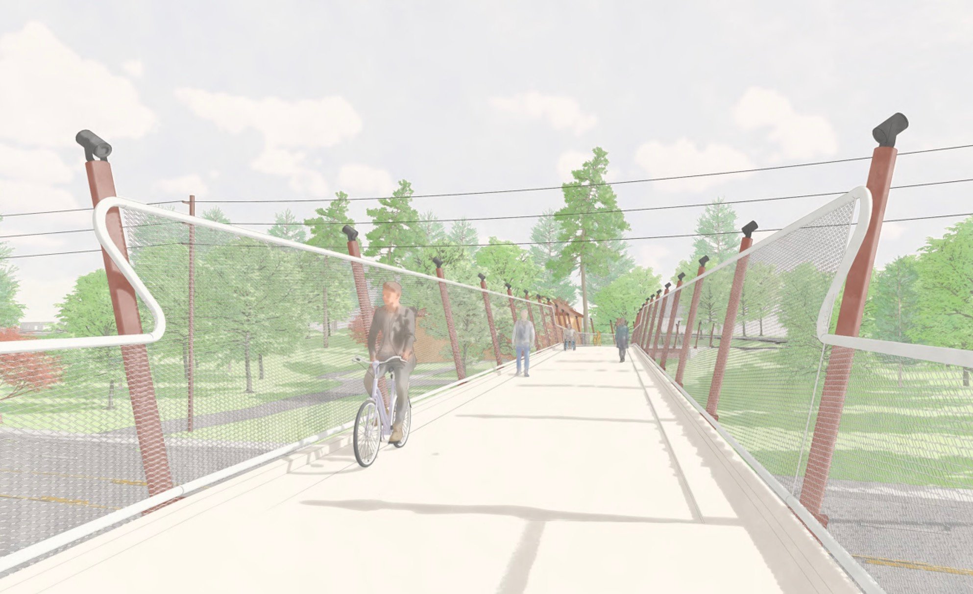
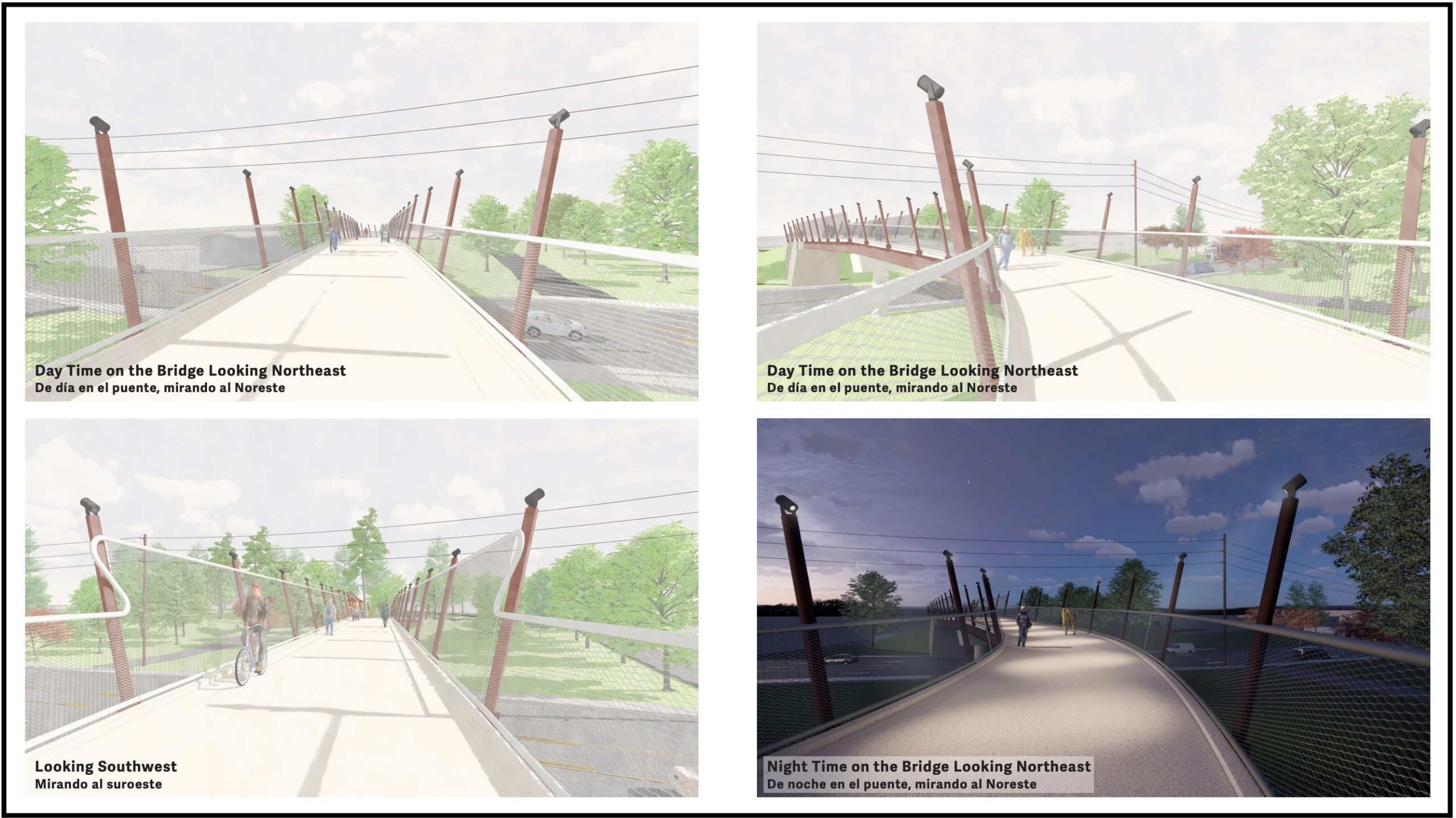
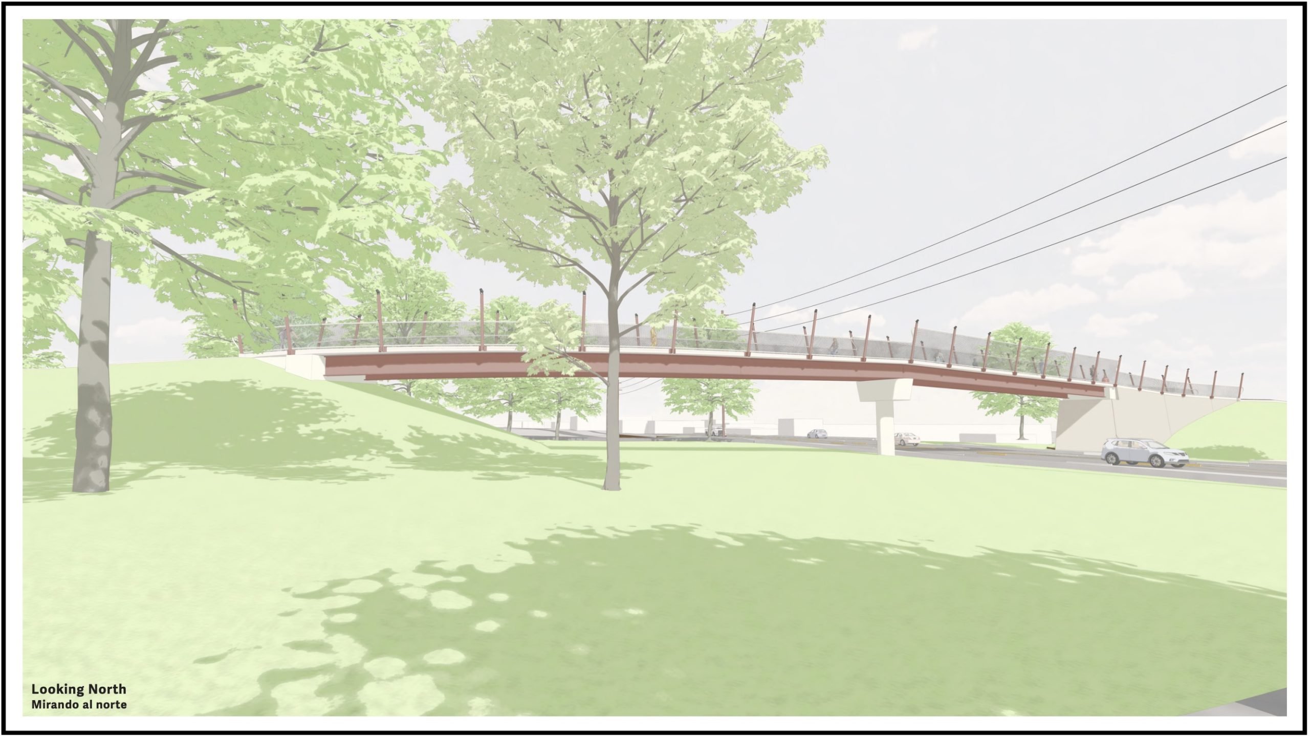
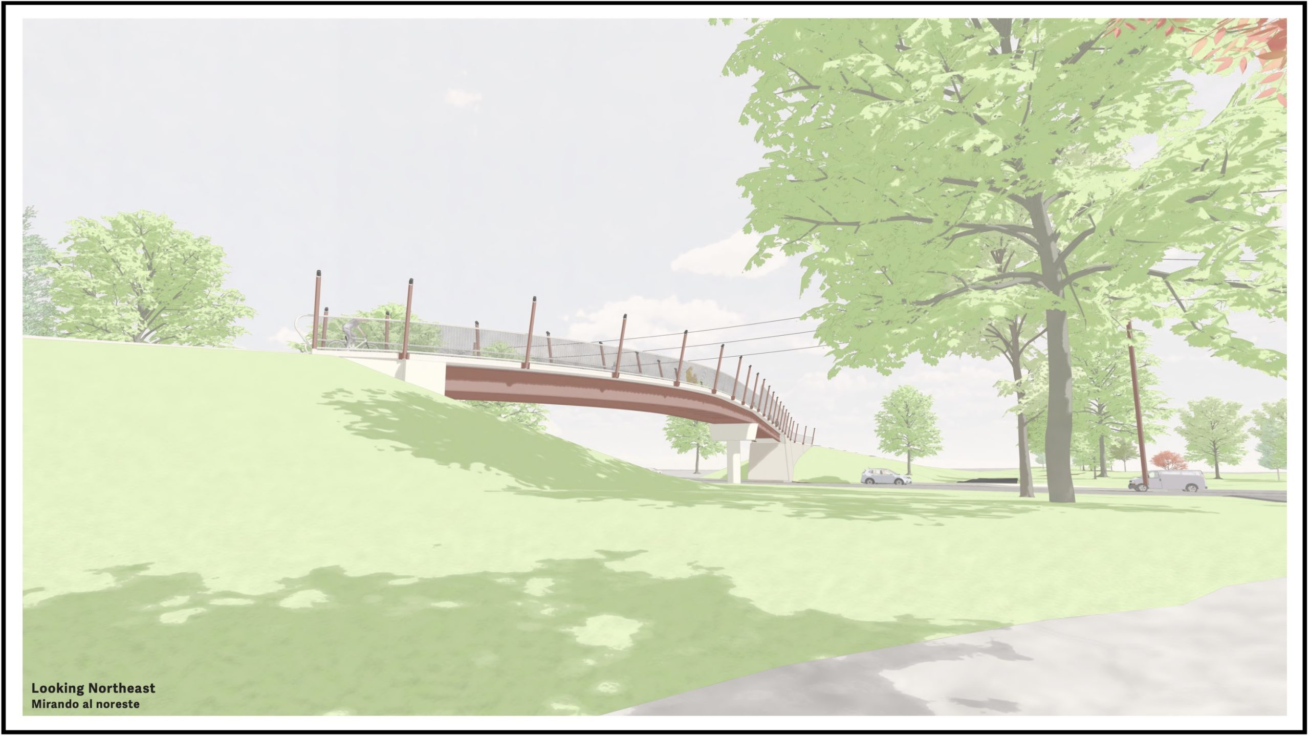
The design of the new Willamette Greenway Trail Bridge over Columbia Boulevard in north Portland was revealed by Portland Parks and Recreation at an open house late last month. New renderings show a structure that will span across the road with transparent fencing and lighting that will make the bridge safer to use at night.
Parks’ Bridge Over Columbia project was on hold for several years as the city ironed out some funding wrinkles. Now it’s full steam ahead and the new drawings give us our best view yet on what to expect.
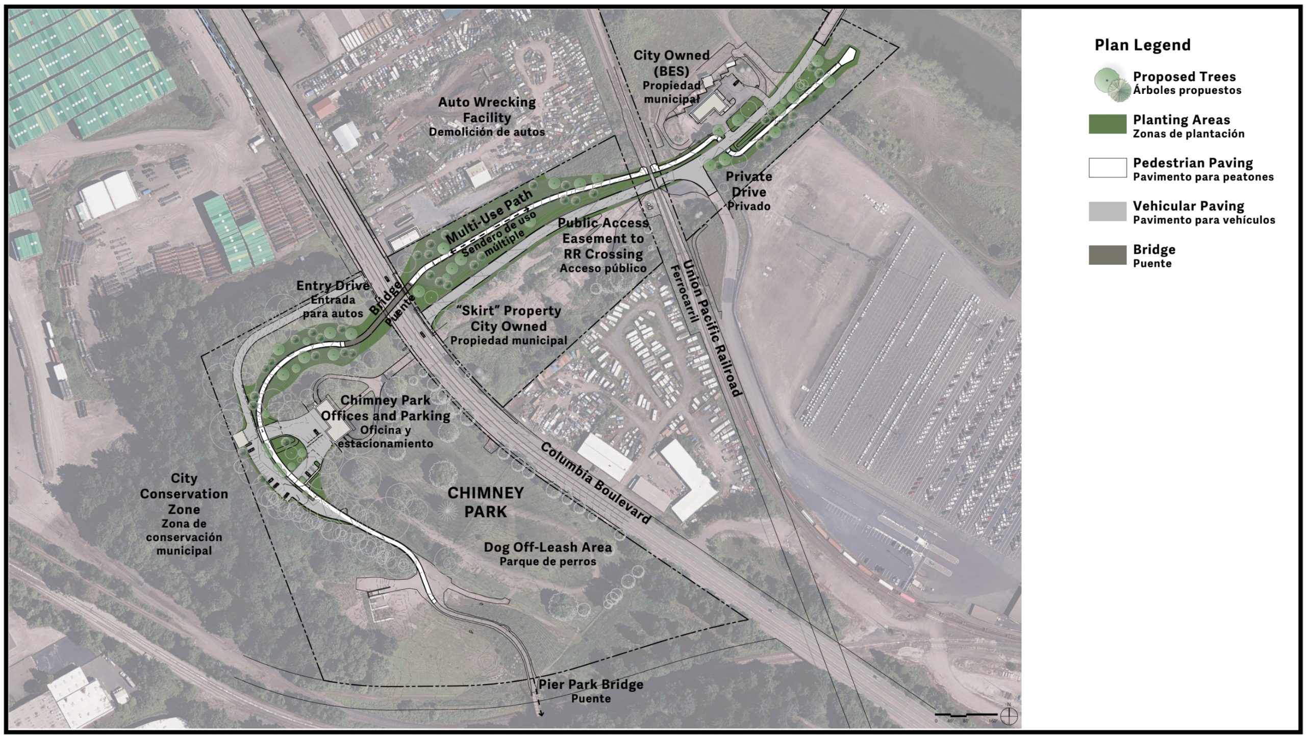
This project, estimated to cost $11-$15 million, will build a half-mile of new paved path inside Chimney Park (just north of Pier Park). That path will connect to a new bridge that will span over Columbia Blvd on a gentle grade. After coming off the bridge, riders will continue on the new path, cross a Union Pacific Railroad track, and then continue northeast to the edge of the North Columbia Slough.
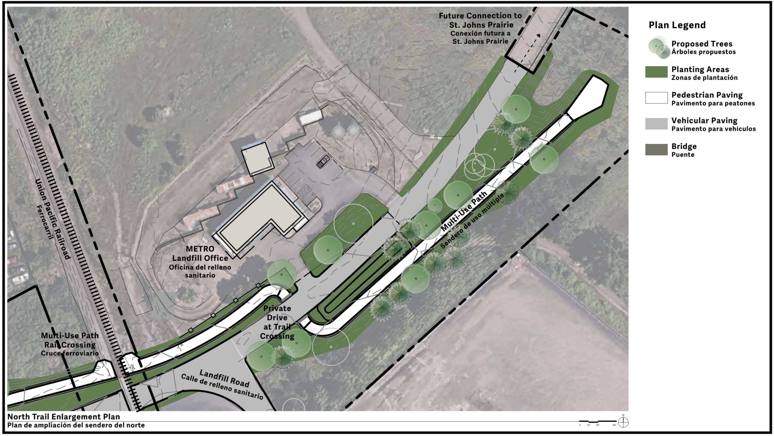
An existing bridge over the slough (owned by Metro) will eventually connect the new path to another future path that will wind two miles around the outside edge of Metro’s St Johns Prairie (a 244-acre former landfill). At the northern tip of the Prairie, Metro and their partners are already planning another new bridge that will ultimately connect to an existing (although heavily damaged and in need of repair) path that leads to Kelley Point Park.
Check out more of the open house materials below:

This project marks very exciting steps forward for the NP Greenway that will eventually connect the Eastbank Esplanade to Kelley Point Park. Parks expects to finish design next year and build the project in 2027-2028. For more information, see the project website.
UPDATE, 8/21 at 8:50 am: I replaced two of the aerial images with updated versions after realizing that the proportions were out of whack. Sorry for any confusion.


Thanks for reading.
BikePortland has served this community with independent community journalism since 2005. We rely on subscriptions from readers like you to survive. Your financial support is vital in keeping this valuable resource alive and well.
Please subscribe today to strengthen and expand our work.
Anyone know the current status of the St. John’s Landfill and gas remediation? I’m not aware of any opening date yet.
I saw an update last month from an email newsletter sent out to the NP Greenway. It was sent by Rod Wojtanik/Metro:
I am skeptical that this bridge cannot support bikes and peds since they drive trucks over it daily, hopefully Metro can be pressured to give the public access to this public resource.
Nice, thanks. I’m assuming it’s this bridge. It’s mostly moot until the ped bridge is built, although there is technically access through the back side trail.
I agree that that is the bridge they are referencing. Hopefully they will retrofit in time for the ped bridge opening
What’s with the air photos not aligning with the line drawing? That’s just sloppy.
Hi Jess. Not sure I understand what you are describing.
Look at the second diagram. The railroad tracks and overlay appear to be off by something like 50ft. I don’t think that moving a bunch of property lines and a private railroad are within the scope of this project?
But at least they have Spanish on there. I guess they are focused on the important things.
The super-imposed graphic image is at a different scale, roughly 2x, from the underlying air photo image. Where they are showing Columbia Blvd on the map is on top of the image a frontage road along the railroad tracks. The railroad alignment is off by about 1,000 feet.
Looks like the scale is also incorrect.
Facepalm moment… I tried for 5 minutes to line anything up on caltopo and just couldn’t. And I am a GIS person.
I’ve biked a few times, pedal and motor, along Columbia. The proposal seems simple enough, needing not much elaboration of design. Just don’t ask me about any Rose Quarter I-5 screw-up or Wheeler’s Marquam Bridge tunnel replacement nonsense.
I also appreciate the effort to include our immigrant communities.
Are you complaining about the use of Spanish on the documents prepared for an open house for a project in St Johns?
The zoom on the aerials doesn’t match the zoom on the schematic project diagrams that are overlayed on the aerials.
The aerial in the first map shows an area that is northwest of Colombia boulevard, but the diagram that overlays the aerial shows paths and structures that are on both sides of Columbia. There is a complete misalignment between the diagram and the image.
Wow, the first image is REALLY messed up.
You’re right, the graphic is several times smaller than it should be, and just randomly placed over the aerial photo.
The second image, which is a close-up of the northeastern portion of the project, looks correct to me, but don’t hold me to that.
The other views showing how it all looks from the ground and on the bridge, and (the most important thing) the project itself, look much better.
My guess is they’ll still put the bridge in the right place.
Are they relocating the Union Pacific tracks? The diagram certainly makes it look like they are.
Why is there no bike bridge over the railroad tracks? That is a major line from the UP intermodal yards.
Good question. Very big trains roll through there regularly. One can expect frequent trail blockages there.
Great to see, I love connections that are totally separated from vehicle traffic. Hopefully the rest of the N Portland greenway can get built soon.
If I didn’t know this was a legit plan I would be suspicious that it was engagement farming to get clicks and comments. After all, why else would the experts put forth a concept to spend $14 million on bike infrastructure that is purely for a relatively small population of recreational riders and highly likely to be blocked and/or damaged by houseless residents when there are so many other needs to improve safety for actual known communities of commuting riders in Northeast and Southeast. If it is engagement farming, I fell for it!
A fair number of people work in the area and commute by bike. One of them was killed crossing an intersection near this project a couple of years ago. So while this project might not be on the top of my priority list, I think it’s very worthwhile. I also think, as a community, it makes sense for us to support improvements even when we don’t perceive any direct personal benefit. You can count on my support for improvements that benefit the “actual known communities of commuting riders in NE and SE.”
Agreed Micah. It may seem like splitting hairs, but this is funded by PPR. There’s certainly an argument to be made whether we should be moving money to PPR for this purpose, or prioritizing PBoT funding more. And it’s clear this isn’t going to increase modal share like separating SE Ankeny or NE 7th would do, but it will make this area orders of magnitude safer and more accessible.
To be clear SE Ankeny, NE 7th, or Broadway can be separated with minimal effort/funding. It’s just the reluctance of the mayor/council that keeps that from happening. So we build projects that have political support instead like this.
Both Metro and the NPG have put in a lot of years/funding to make this happen, and recreational cycling/rolling and hiking (don’t forget that) on this scale is often underestimated for how much money it brings in (not to mention the value of just simple fun).
I’m slightly confused why the other bridge is necessary since there’s already access at the NE corner to that trail, but maybe it’s for ADA purposes?
earwriste,
Here is my understanding of the various bridges: the bridge proposed in this project/article crosses Columbia Blvd. and connects to St Johns Prairie(SJP- former landfill). To get to the SJP from the northern foot of the bridge, the bike path will cross the RR tracks on-grade, then cross the existing bridge over the slough on the south side of the SJP. This is the bridge Metro is claiming is not structurally sound enough for bikes and peds even though they use it to access the SJP via truck daily. Once over the slough, Metro has designed a path around the east side of the SJP with views of the lakes, continuing along the slough on the north side of the SJP- they haven’t built this path yet because of the claimed issue with the bridge, but it was funded at one time. The project you linked to is the NW corner of the SJP and installs a new bridge over the (north) slough to an existing trail, and repairs that trail which connects to an existing underpass under Marine/Lombard and the new trail connection into Kelly Point Park.
I think eawriste’s point may be that the bridge at the NW corner might not be strictly necessary to complete the gap between KPP and Chimney Park (assuming the bridge over Columbia is built and the south side SJP bridge is fixed/replaced) because there is an existing bridge over the slough at the NE corner of the landfill and a use trail (e.g.) along the north side that can connect to KPP. So then why blame the south side SJP bridge for the hold-up on opening up the SJP part?
Thanks for clarifying, I misunderstood!
Thanks maxD. I’ve been through the back way from the North via Marine Drive here and there’s access to the landfill at the NE side here. So it seems a little redundant building another bridge at the NW side. My best guess is the owner of the land just north of SJP (Port of Portland) wants to limit access to their ROW, and it’s possible the existing N/S trail will be purchased by, or possibly used via an easement with, metro.
Gotcha! I misunderstood. I thought that “bridge was more of a weir and was possibly underwater in the winter, but looking at the air photo I am rethinking that! Can you bushwack along the north side of the the slough to the bridge? I’m going to have to check that out before it gets too rainy!
Dang, i live in this area and can definitely get behind this project… but the lack of attention to detail with these images in relation to a 15 million dollar project is just lazy and unacceptable. The whole project seems a bit short sighted. To spend this much money but not have a bridge to cross the UP tracks is just silly, as very long trains go by regularly and often slow or stop in this area. Its great that it would potentially connect to more improvements in the future, but currently its just a recreational trail to nowhere??
Underpass?
The maps have issues. The likely placement of the bridge as far as I can tell is 45.60853, -122.75913. This will make for car-free connection from Chimney Park to the City Dump Road bridge.
As a co-founder of Friends of the North Portland Greenway over 20 years ago, I am cheered by this latest update on the Columbia Blvd. Bridge project…looks great, but saddened by the failed bridge across the southern branch of the Slough. Getting access to the recovering St Johns Prairie is a real plus of the C. Blvd Bridge project. I hope Metro will dig a bit deeper to find the needed resources to fix and then replace the southern Slough Bridge.
Then its on to the other needed Slough bridge north of the Prairie. With that we will have an spectacular and relatively direct connection between Pier Park in St Johns and Kelley Point Park…not to mention a viable transportation option for the thousands who work in Rivergate. Add to that the improving prospects for Baltimore Woods, Willamette Cove, Baxter-McCormick, and we may yet have a world class riverside trail in N,. Portland.
Good point, we have centers of employment (and other trip generators including natural areas and a major airport) that don’t generate many alternate transportation trips at present. Few bike riders appear, so we hear that there is no reason to fill in conspicuous gaps in biking and walking infrastructure.