“We believe the needs of our marginalized voices are being ignored. The disparity of funding that is coming out to Washington County is stark.”
– Steve Callaway, Mayor of Hillsboro
Last spring, we looked at some of the projects transportation agencies in the Portland metro area asked Metro to fund through their 2025-2027 Regional Flexible Funds Allocation (RFFA) cycle. Now, Metro’s Joint Policy Advisory Committee on Transportation (JPACT) has selected 11 of these projects to recommend Metro fund, split up between various jurisdictions in the region.
Regional flexible funds – deemed “flexible” because local jurisdictions have discretion over how the money is spent, unlike with many other prescribed federal funding programs – consists of federal transportation money distributed to transportation agencies via Metro. This flexibility “allows for greater focus on local priorities and innovative solutions to transportation challenges”– a.k.a. not car-oriented highway projects.
Metro received public comment for the projects and the Metro Transportation Policy Alternatives Committee (TPAC) took several months to decide which were the right picks to receive funding. Some of the projects not approved for funding through the RFFA process will receive money through the Parks Bond measure, which Metro Council will sign off on at the end of this month.
Some policymakers outside Portland are disappointed about projects left unfunded in their areas and are using this process as an opportunity to start a larger conversation about fairness in regional investment fairness.
“Washington County is the most diverse county in the state. But we believe that a lot of the needs of our marginalized voices are being ignored. The disparity of funding that is coming out to Washington County is stark,” Hillsboro Mayor Steve Callaway said at the September 15th JPACT meeting. “It is also worth noting that there are cities in Washington County that did not even bring projects forward because they knew that they would not receive any votes that would increase their standing.”
One project in Washington County that TPAC did not initially approve funding for is the Allen Blvd Complete Streets project in Beaverton. But during last week’s JPACT meeting, policymakers opted to move some of their allocated money around to ensure they could begin work on the project.
“We can’t leave Allen Blvd unfunded. We have the most diversity in Beaverton concentrated in Allen Blvd. It’s a corridor in a community that has been historically underfunded when it comes to transportation improvement,” Washington County Commissioner Nafisa Fai said. “We’re going to fight among our small crumbs and make an amendment to move $500,000 of the Fanno Creek funding to Allen Blvd. Then we’ll make up the difference and figure out how we can get both projects up and ready in Washington County.”
Washington County received about $9 million in RFFA funds compared to the more than $33 million designated for Multnomah County/City of Portland projects. That left about $4.5 million for two projects in Clackamas County. Representatives from Washington and Clackamas Counties asked to have a discussion about regional parity in funding allocation in the next RFFA cycle, which won’t begin talks until 2024.
Since Metro plans how to spend this funding so early, we’ll have to wait until at least 2025 to see any real action on these projects. But after they sign off on them on October 13th, at least the first step will be done.
Below are the projects JPACT has approved for Metro Council to sign off on. Since not all of these received the full funding they requested, their descriptions may be subject to change.
City of Portland
The City of Portland applied for funding for nine projects and received funding for three, leaving six unfunded. The biggest are the SE 7th Ave Complete Street Project and the SW Taylors Ferry Walkway & Bikeway project, which Portland wanted about $11 and $10 million for respectively. Now the city will need to come up with a new source of funding if they want to build those projects. Portland received funding for three projects, outlined below:
148th Ave Safety and Access to Transit ($7,100,335)

NE/SE 148th Ave (Halsey – Powell). Improve existing bike lanes, add enhanced crossings and support planned new TriMet bus line. Addresses high priority PedPDX crossing needs throughout the corridor.
NE Cully Blvd / NE 57th Ave Complete Street Project ($7,643,201)

NE Cully Blvd / 57th Ave (Prescott – Klickitat) Fill sidewalk gap on west side of 57th and widen narrow sidewalk on east side of 57th from Fremont to Failing. Provide protected bike lanes from Klickitat to Prescott. Add transit islands at Mason and new crossings at Failing and Skidmore.
North Portland Greenway – Columbia Bl to Cathedral Pk ($4,860,647)

N Columbia Blvd, N Bruce Ave, N Reno Ave, and N Catlin Ave. Bike and pedestrian bridge at N Columbia Blvd at Chimney Park, paved multi-use path at Baltimore Woods, and connections to and improvements throughout N Portland greenways in St Johns area.
Regional
NE 162nd Avenue Complete Street plan – City of Gresham ($7,575,882)

The project will construct continuous and ADA-compliant sidewalks, curbs, curb ramps, and buffered bicycle lanes from NE Glisan Street to NE Halsey Street. Improvements at the NE 162nd Avenue and NE Holladay Street intersection will include construction of sidewalks, ADA-compliant curb ramps, signal backer plates and more protection for bicyclists at the intersection. To support access to transit, the project will construct a Rectangular Rapid Flash Beacon crossing at NE Holladay Street to access the bus stops adjacent to the new affordable housing constructed on the Albertina Kerr campus.
Beaverton Creek Trail – Tualatin Hills Parks & Rec ($2,055,647)
The project will include final engineering, permitting and construction of a 1.5‐mile, 12-foot wide regional trail segment which will provide a critical and direct connection to transit, employment, commercial centers, and existing THPRD facilities.
Council Creek Trail – Washington County ($5,511,000)
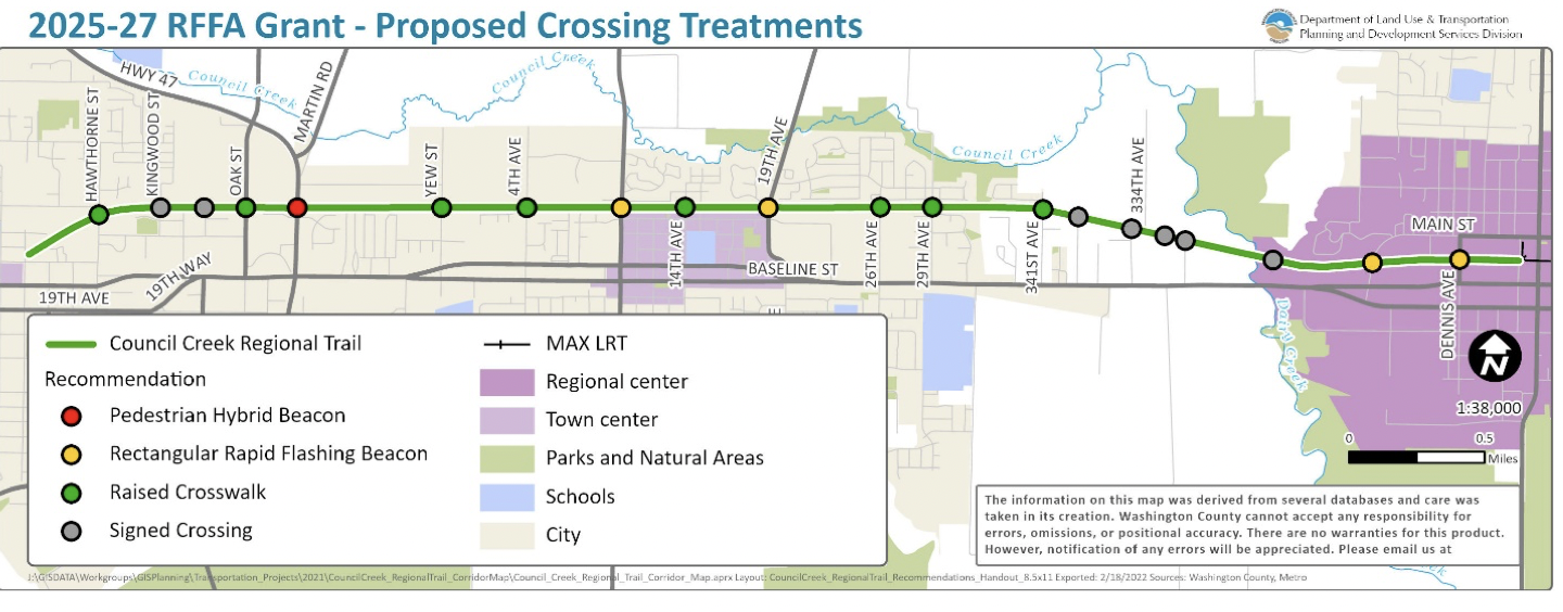
The proposed project would design and implement 20 street and driveway crossings along the Council Creek Regional Trail corridor between Adams Avenue in Hillsboro and Douglas Street in Forest Grove. These crossings would facilitate safe, convenient, and comfortable connections for people walking, biking or rolling between the centers of Forest Grove, Cornelius and Hillsboro. The project includes enhanced crossings at 13 arterial and collector roadways, and minor investments at 7 additional local street and driveway crossings, including associated traffic calming elements.
Fanno Creek Trail – City of Tigard ($1,106,705
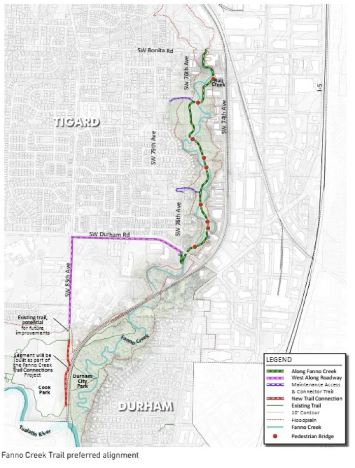
The proposed project would provide critical site analysis to prepare for funding, easement acquisition, design, and construction of the most technically challenging trail gap between SW Bonita Road to SW Durham Road. The trail alignment moves users south from SW Bonita Road, along the east bank of Fanno Creek, through the Bonita Natural Area, and connects to existing bike lane and sidewalk on SW Durham Road. The trail will be 12 feet wide with shoulders (as shown in the cross section). Bridges and boardwalks will be 14 feet wide.
I-205 Multi-Use Path – Clackamas County ($1,094,858)
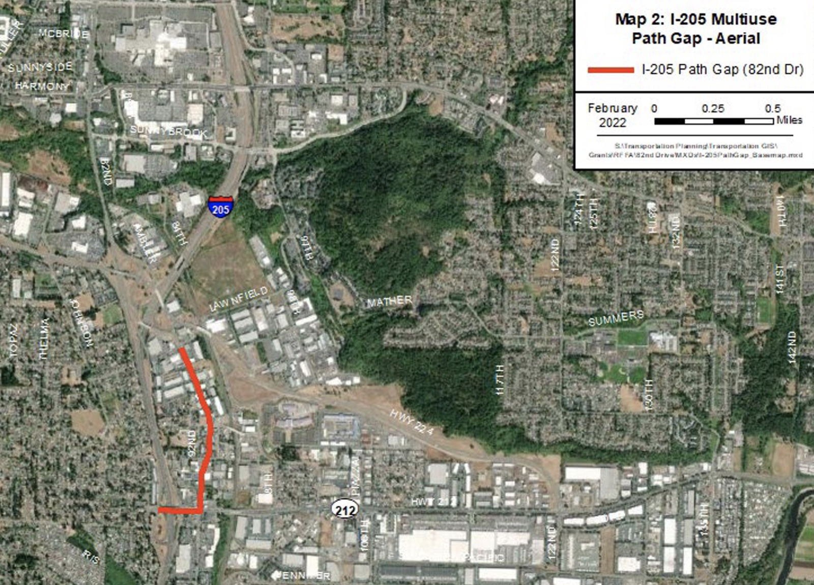
The I-205 Multiuse Path (205 MUP) provides a near continuous off-street facility from Vancouver, Washington to Gladstone with the exception of a one-mile gap between Hwy. 212 and Hwy. 224 in Clackamas County. This project will develop a community-backed design solution for a preferred route within the one-mile gap in order to facilitate non-vehicle transportation and improve safety and accessibility.
NE Sandy Boulevard Complete Street: Gresham City Limits to NE 230th Avenue – Multnomah County ($6,500,000)
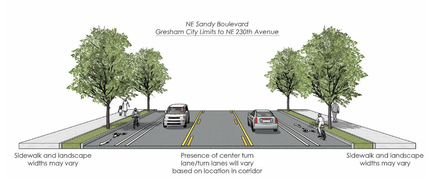
The purpose of this project is to transform NE Sandy Boulevard from Gresham City Limits to NE 230th Avenue into a complete street. This designated active transportation and freight corridor will be improved to increase the safety, comfort, and connectivity for multimodal users by filling in critical network gaps and implementing proven safety countermeasures to reduce fatal and serious injury crashes. The project is aligned with the regional investment priorities, including safety, equity, climate, and congestion relief.
The proposed design maintains two (2) through lanes, adds a center turn lane/turn lane at strategic locations, and fills the pedestrian and bicycle and facility gap(s) along NE Sandy Boulevard between Gresham City Limits and 230th Avenue. In most locations, sidewalks will be buffered with a landscape strip and bicycle facilities will be buffered to provide additional separation.
Willamette Falls Drive Multimodal Project – City of West Linn ($3,497,580)

This regionally significant multimodal and safety improvements project will greatly enhance bike, pedestrian, and transit mobility along Willamette Falls Drive between 16th St. and Ostman Rd. The proposed project will result in the continuation of uninterrupted, grade-separated protected bicycle paths and sidewalks with a consistent two lane vehicle cross section. The project is focused on multimodal safety and largely fills a gap in this regional bike corridor that parallels I-205. In addition to safety improvements, the project will improve equitable access to dedicated bike and pedestrian facilities providing a direct connection to the City’s Historic Main Street business center.
Allen Blvd Complete Street Plan – City of Beaverton ($500,000)

The Allen Boulevard Complete Street Plan project will undertake a planning process to identify transportation investments with community input and engagement in alignment with the City’s adopted Context Sensitive Design policy. The project will develop a plan to create a multimodal corridor that prioritizes mobility and access for people with a range of needs and physical abilities. Design alternatives will consider wider sidewalks with street trees, pedestrian crossing treatments, protected bike lanes, improved transit stops, and street lighting. The project will also consider new traffic signals, signal timing changes and transit signal priority to help keep buses on schedule. The roadway’s existing constrained right of way will prompt the project to explore right of way acquisition, as well as narrowing travel lanes and a three-lane cross-section.


Thanks for reading.
BikePortland has served this community with independent community journalism since 2005. We rely on subscriptions from readers like you to survive. Your financial support is vital in keeping this valuable resource alive and well.
Please subscribe today to strengthen and expand our work.
SO HAPPY to hear that the Westside Trail bridge over Highway 26 got funding! That’s going to be an absolute game-changer for everyone living in the area, allowing people to cross 26 without going through a stressful highway interchange at either Murray or Cornell.
The Hillsboro to Forest Grove trail is going to be similarly game-changing; finally people won’t have to walk or bike along the stressful TV Highway to get between these cities. Huge news for Pacific University and people who travel between the two cities frequently (which is a large number of people judging by TV Highway’s traffic in the area).
I’m having trouble finding where exactly this would cross. Do you have a link to the project site or know the routing?
I believe it would cross between Cornell and Murray, at the powerline corridor. But I could be wrong on this.
Got it now, thanks. Its cool to have another connector across the freeway, doesn’t really help my east west commute, but I’m generally nonplussed going across the Cornell bridge for the sake of efficiency.
THPRD’s Westside Trail over 26 did not get funding.
THPRD Beaverton Creek Trail and Washington County’s Council Creek Trail did.
Ah shoot, thanks for the clarification. The illustration above is wrong 🙁 Oh well, the Beaverton Creek trail is still better than nothing.
It’s unfortunate that NE MLK Jr safety to transit plan phase 2 (Lombard to Fremont) was not funded this go around. I only cross MLK at lights as a red or cyclist as motorists rarely stop at zebra crossings if there is a person waiting and the median vegetation makes visibility low. I absolutely want to preserve those trees (cries in Tillamook & 7th) so I think crossing lights and other methods to slow or make motorists aware of ped/bike traffic is really warranted.
Looks like I was mistaken about the MLK Safety to transit – It was funded! Looks like those improvements won’t be made until 2024-25 though.
“Phase 1” was funded in the last round. This new one would have been a “Phase 2” with more crossings.
Ohh geez. That is disappointing. I’m encouraged that phase 1 was funded, but if that means that Phase 1 work will not start until ’24-’25 – We can expect phase 2 work (if funded) to commence closer to 2030 and that’s just a wildly long timeline.
It’s extremely disappointing this project wasn’t funded, given it was Portland’s highest-scoring project by Metro’s own accounting (pg 64).
Don’t worry Mayor Callaway (Hillsboro): this whole process is (actually) rigged and doesn’t involve the rigorous application of anything other than optics (not enough projects in mid/east county!) and getting your buddies on JPACT to vote for your project (they literally teach you this in school!). Metro Council has the power to send this distorted project list back to JPACT with a “try again!” sticky on the front, but Metro Council is a rubber stamp that doesn’t stand up for outcomes-based approaches here or generally.
Former council member Robert Liberty’s words of testimony at Metro Council’s depressing vote on the CRC 2.0 LPA echo once more: “there’s pressure to go along to get along”. =)
I think the Beaverton Creek trail is not the same as the Westside Regional trail bridge
Thank you, I was confused by that. The Beaverton Creek Trail is the proposed east-west trail along the MAX blue line between the Westside trail (at the Nature Park) and approximately SW HockenHocken.
Yup, just updated it. Not sure why I included that photo, but was a mistake. Thanks for letting me know!
Does this mean the west side regional trail bridge is not funded? Somehow I remember it being approved for funding sometimes in the last couple of years?
Ah thanks for the clarification. Still good, but not as good as I’d hoped.
Regarding the North Portland Greenway project: Chimney ‘Park’ and St Johns ‘Prairie’ are respectively, the site of an old trash incinerator and the St Johns Landfill, where Portland’s solid waste was disposed of for many, many years. I’m not sure why anyone would actually want to recreate adjacent to a huge closed landfill which completely destroyed the natural habitat that used to exist there.
FDUP, you are correct about the history of Chimney PArk and St John Prairie, but if you have allowed your prejudice to prevent you from visiting, I encourage you to give them a chance. Pier park is a large, beautiful park with a great trail network and a lot of beautiful mature trees. There is a bike/ped bridge over RR tracks to Chimney Park. Chimney park has a handful of mature trees, the remnant buildings are architecturally and historically intersting, and there are some nice views toward St Johns Prairie and Smith and Bybee Lakes. St Johns Prairie is not open to the public, but there are plans in the works 1) a bridge over Columbia Blvd between St Johns Prairie and Chimney Park, and 2) a path around the east side and north with and overlook to view Smith and Bybee Lakes. Although it is a former landfill, the experience of being there is visitant one of the most intact prairies I have visited in the Willamette Valley. Rolling hills, a healthy mix of native grasses and wildflowers, amazing views of the lakes and riparian forest at Smith and Bybee Lakes. The birdwatching at St Johns Prairie and at Smith Bybee is incredible- it is a real jewell in the City and connecting through it to Kelly Point will be an incredible recreational opportunity.
As you can tell, this is aplace I love, and I thing the NP Greenway trail has incredible potential. I am mystified that Portland doesn’t prioritize this more, though. When PP&R did the NP Greenway plan, they insisted on only proposing “practical” solutions that routed the trail on roads and treated it like a transportation connector. When I dream about this trail, I think more Eastban Esplanade from the Steel Bridge up to Greeley, then more a network of trails along the bluff all the way to the University of Portland. There could be hiking trails connecting parkes and through Oaks near Adidas and Fennel Park, a pair of trails (bike and ped) along the base with lots of benches and overlooks. There could be a sweet spur or loop to the beaches of Swan Island. After UP, the path is practically there, just waiting to paved up to Cathedral Park. From Cathedral Park, a quiet connection along Decatur could connect through the Baltimore woods to Pier Park, to Chimney park, to St Johns Prairie and along the Columbia Slough to Kelly Point Park without an at grade street crossing.
Really, go check out Chimney Park, and visit Smith and Bybee Lakes if you haven’t already, it is a really special part of Portland.
The unbuilt part of the NP greenway trail that is much more critical is the connector between Swan Island and the bluff below the University of Portland. The city owns the former St Johns landfill so that segment is easy for them; the Swan Island connector is along RR ROW and through several Portland Harbor toxic waste sites so it is more difficult. The St Johns landfill site may now look like a ‘beautiful prairie’ but I’m pretty sure it continues to leach toxins into the groundwater and the adjacent slough, so don’t eat the fish.
agreed that connecting swan island both to the esplanade and around the bluff are the most important connectors, recognizing the 10k plus workers on swan island and all freight are limited to going st.
the challenge is both the cement road and the ROW at the bluff are railroad owned, and Union Pacific does not at this time see the need to allow these connections to happen. Things may change.
In the meantime, building those other connections and pieces need to move forward. the prairie to cathedral park piece being completed is a big piece, once the willamette cove is resolved, connection to the bluff is not impossible, difficult or that expensive. I see the solution to the bluff being built on the side of the bluff and connecting to the waud bluff piece, ramping down to the end of basin.
Rome was not built in a day, nor will npGreenway.
Metro likes this project because its a way to pretend about alternative transportation without impacting motorist speed or access.
So they want to spend $5 million to create a bike path to nowhere, meanwhile I have to mount the sidewalk to leave St. Johns and there is no safe direct way to bike to downtown.
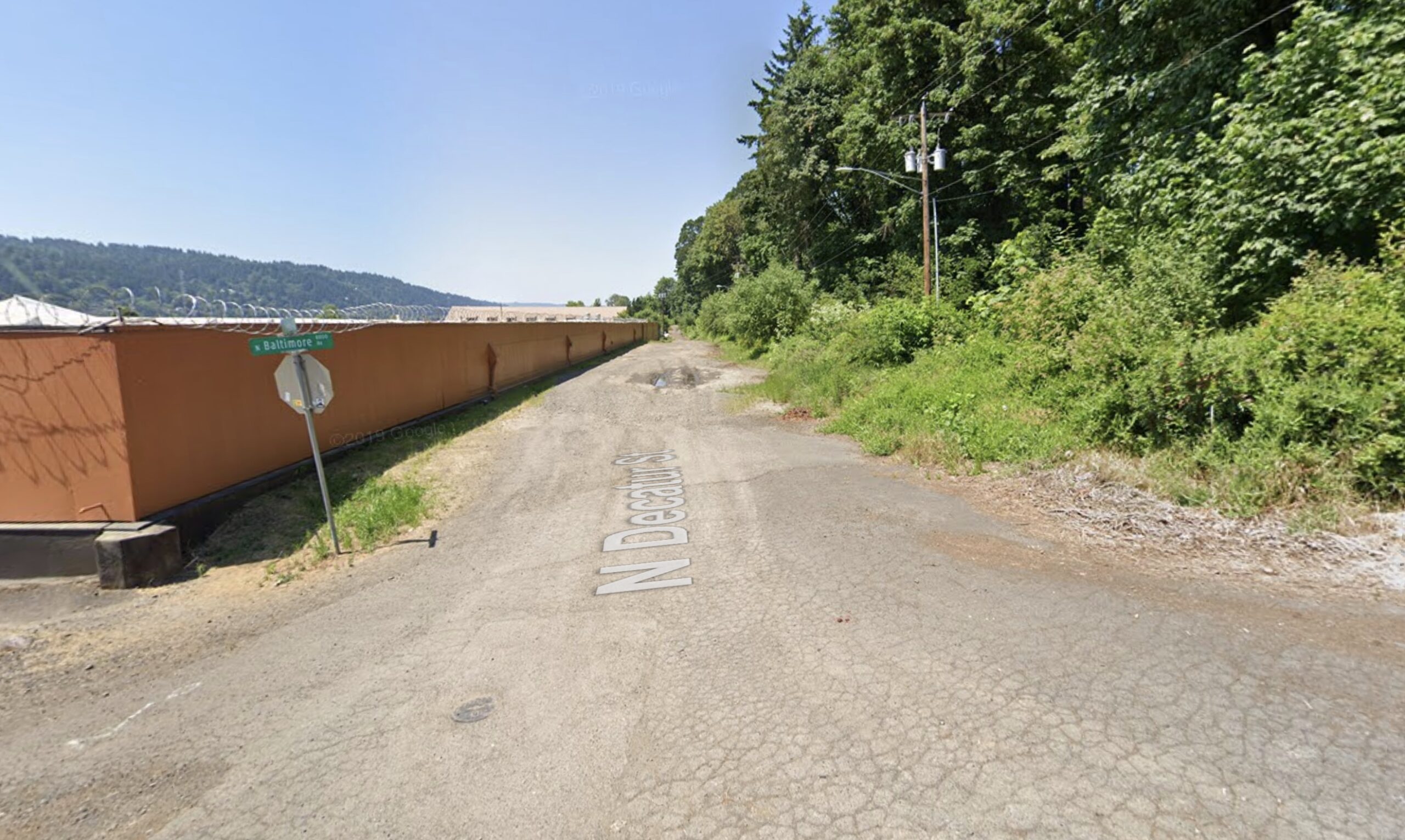
I’m glad to see the North Portland Greenway moving forward, but I’m curious if there are any near term plans to create a trail along N Decauter St? Without that the Baltimore woods section looks like it will be of pretty limited utility.
To pick nits about the headline: “148th among 11” sounded vaguely sensationalized, as though NP Greenway is a low priority. Reversing the project order or adding the street designation would clarify that for my bleary morning eyes.
Totally agree. That was a bad headline. I’ve changed it.
This is a minor correction (feel free to delete this comment), but the I-205 Multiuse Path should be under Clackamas County, not City of Clackamas.
Thanks John, changed it!