
Earlier this month, elected officials overseeing the Interstate Bridge Replacement (IBR) project got a look at new renderings showing what a remade I-5 could look like on Hayden Island and its connection to the rest of Portland.
Within the last few months, the IBR has taken all but two alternatives for interchanges on the mainland Portland side off the table. On a website that details next steps and the latest design renderings for the project, we can now see a “full” and “partial” interchange option. These images come after startling renderings of how the new highway would impact downtown Vancouver were revealed earlier this year.
Here’s the full interchange option:


And the partial interchange:
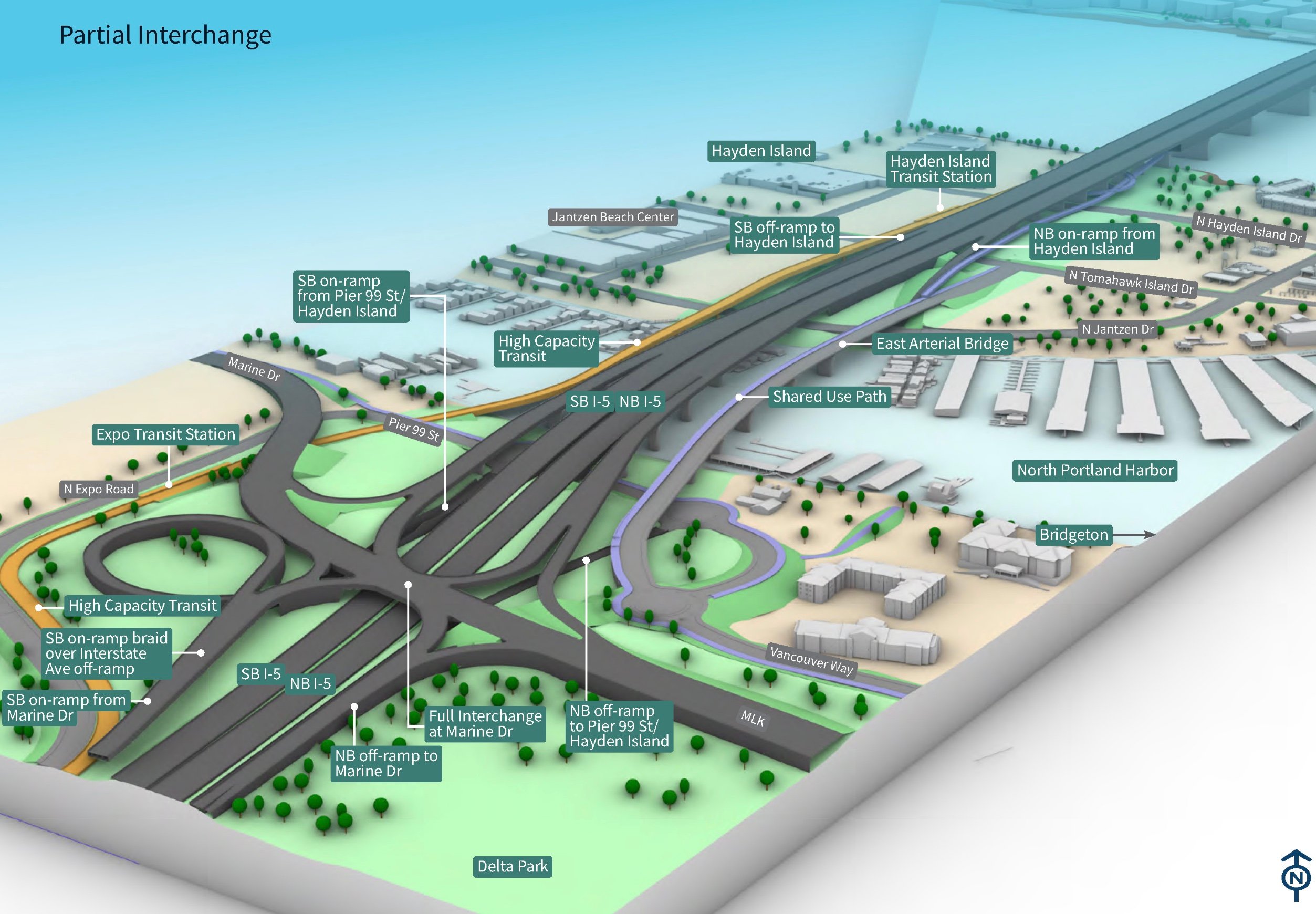


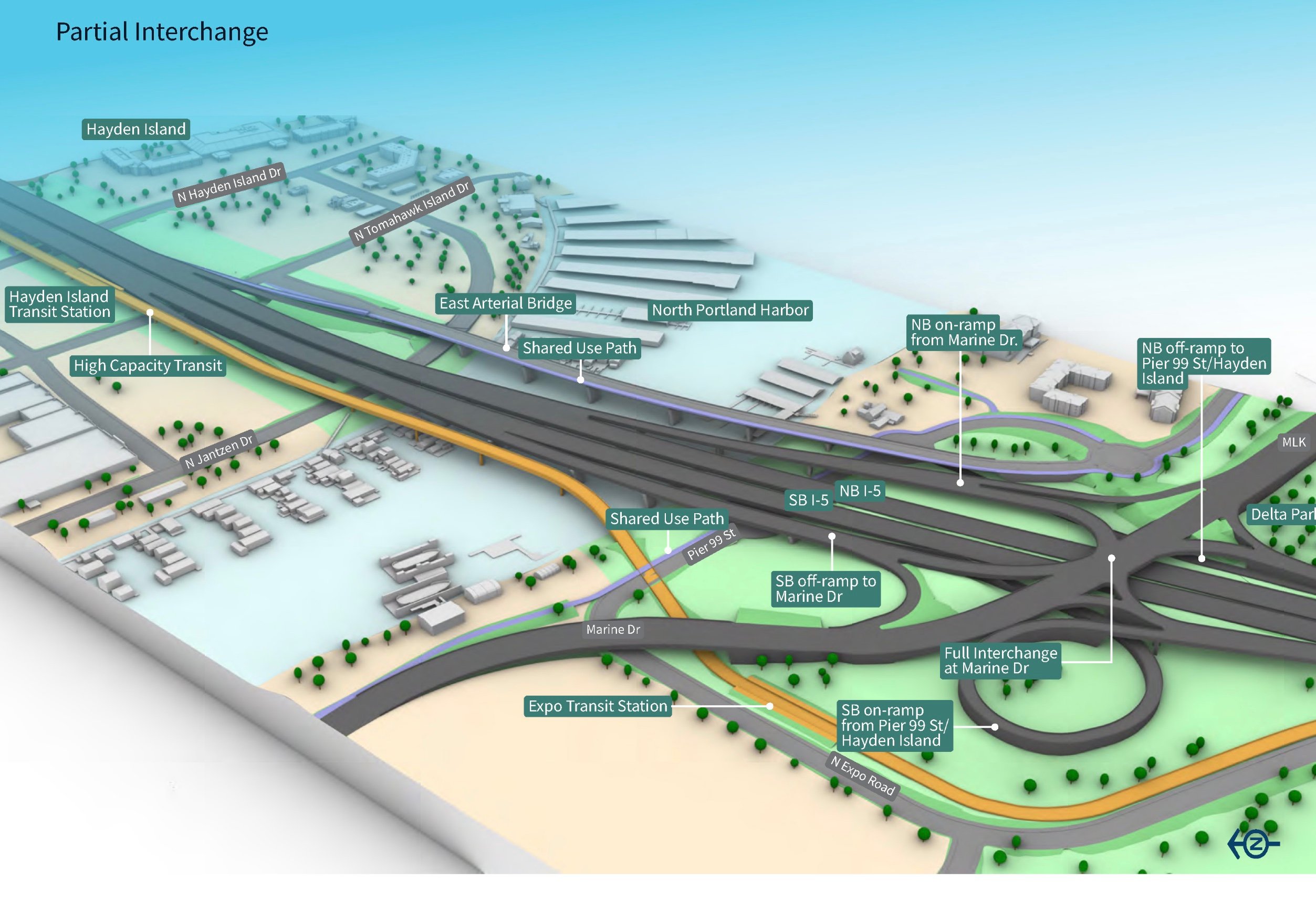
The renderings also provide an early look at what a walking and biking path alongside the new highway will look like, as well as a rough idea of how the “high capacity” transit element (either light rail or bus rapid transit) will fit in. The shared use path is planned to be built next to a separate bridge for local traffic between north Portland and Hayden Island, with the transit line either built alongside or on the other side of I-5.
The renderings illustrate the full scale of the highway project, but don’t fully show the impacts of property acquisition that will need to occur: a decade ago, the Columbia River Crossing was set to purchase significant property on Hayden Island for construction.
Advertisement
The clear illustration of space for people on bikes and in transit illustrated in these new renderings comes as gubernatorial candidate Betsy Johnson shares her fringe views on the project, calling for no transit whatsoever, no space for bikes and no “pedestrian super-accommodation” (whatever that means). Upgrading the bike and pedestrian infrastructure on the bridge is part of the project’s federally required “purpose and need” statement, and has always been expected.
Both design options on the table include a Single Point Urban Interchange (SPUI) at NE MLK Blvd and I-5. A SPUI is a type of highway interchange that both Oregon and Washington are starting to construct more frequently, where multiple lanes of traffic turn left and go straight at the same time, directed by a single massive traffic signal. During the Executive Steering Group meeting last week, Metro President Lynn Peterson brought up the SPUI that ODOT has built in Medford at Garfield Street. “It didn’t feel comfortable walking through it, I can tell you that from personal experience,” she said. The shared-use path is designed to steer clear of this interchange, with connections planned on Vancouver Way and Marine Drive.

Peterson also asked how many lanes are represented in these graphics on Hayden Island. That information is still not available to the public, weeks before the project is asking for approval to move forward. “These graphics are not representing of number of lanes, we still have a lot of work to do on that,” Brad Philips, the IBR’s Civil Design Lead said. “But if you were to do a cross-section through Tomahawk [Drive], there are quite a few lanes because of the ramps overlapping at that location, so it’s a pretty complex freeway system across Hayden Island.”
“These graphics are not representing of number of lanes, we still have a lot of work to do on that.”
— Brad Philips, IBR team
The impacts to Hayden Island are going to be a key consideration in the City of Portland endorsing the project’s “modified Locally Preferred Alternative (LPA)”, and the city is currently scheduled to be the first body to be asked to officially endorse that LPA in early June, with the TriMet board of directors and the Vancouver City Council following shortly thereafter. Commissioner Jo Ann Hardesty has been taking ownership of the project so far, and we haven’t seen much weighing in from other commissioners. The Metro Council, likely to be the source of the most pointed discussion of the project, is set to endorse the modified LPA last, in early July before it heads to the bi-state committee of state legislators.
As these deadlines approach, the project team is downplaying the significance of endorsing a modified LPA, framing it as the start of a process to test how the design will perform. But if government bodies from around the region officially give the project the go-ahead, there will likely be few chances to reassess the project and minimal tweaks to the design at most from that point forward. Some of the most contentious issues, like tolling, still lie ahead.
— Learn more about next steps for this project here.


Thanks for reading.
BikePortland has served this community with independent community journalism since 2005. We rely on subscriptions from readers like you to survive. Your financial support is vital in keeping this valuable resource alive and well.
Please subscribe today to strengthen and expand our work.
“…quite a few lanes…”
Obviously the number of lanes and property claims for ROW matter bigly for this project, and I’m still highly skeptical of it. I will say one positive thing – it may have taken decades, but at least the project recognizes the best way to serve Hayden Island from the Portland side is via a local access bridge, NOT from I-5. Removal of the Hayden Island freeway ramps is a positive thing, all other aspects of the project notwithstanding.
(Then again, I’m also of the belief that our metro region can afford to build a local access connector featuring bike/ped/light-rail and motor vehicle access to Hayden Island with out needing to be connected to a freeway megaproject. Let’s not embrace the megaproject just to get a sensible local access project done.)
Update: Wait, I take it all back. Squinting at the renderings there is still a NB ramp from I-5 into Hayden Island, it’s just buried underneath the other highway layers. Sigh.
Y
There’s a note that says “full interchange”. Sigh. The best investment in traffic reduction on I-5 N would be to buy out the Hayden Island mall and depave it, whatever it costs.
Bob, you are onto something here. The current I-5 and Hayden Island bridges should be turned into local access and the IBR moved up to St Helens, with Route 30 turned into I-5.
You read it here first. 🙂
But the new mainspan would allow a longer lane for more merge time, rather than pushing onboarding traffic straight in to a travel lane that is already congested from the MLK on ramp/hayden off ramp debacle.
Again, approaching ZERO people will experience this massive highway expansion from 600 feet in the air. It’s fundamentally dishonest to share these (nicely colored with green parts) images.
We need images on the ground, under the interchanges, of walkways, etc.
Yeah, I think the “green” implies park space… where in reality open land that close to a freeway is essentially part of the freeway right of way and completely worthless from any sort of park stand point
I thought it just implied that it is greenspace/landscaping. No one is calling it a park or expecting it to be a park.
“green area” in medford below I5 is called hawthorne park. use your imagination as to its current use. . .
With the campers, or without? I mean, if we want honest imaging…
How many acres of viaduct is this project building, anyway? This could be part of the regional shelter plan.
A great visualization would driving into Portland on I-5 in either direction to see what a mess of elevated highway does to a city’s riverfront and skyline. Then on foot or bike… take a journey along the (lovely) Eastbank Esplande or venture along Water Ave to OMSI… and you get to see the wonders of I-5 concrete and steel from the underside! Ah, the sights and smells of progress! Ten lanes of traffic at great expense, in every sense of the word.
I don’t think anyone is implying these graphics represent how it will be perceived. It’s literally a map/aerial view, how is that dishonest? How else do you represent a project that is miles long?
These images represent something called a “General Arrangement” or “Schematic Design”, it’s incredibly “high level” from a detailing standpoint. The questions you are asking are irrelevant to this stage of design.
Am I misreading the graphics? Ryan wrote:
But to me it looks like the transit line is always to the west of I-5, along the exposition center.
The transit line is proposed on that side in both options, but the shared use path & local access bridge is proposed to go on the opposite side in the partial interchange option.
So, if I’m biking to Vancouver and cutting through Delta Park as I do now, how do I get to the multi-use path on the northwest of I-5 and Marine Drive?
Looks awesome. And it’s sure to make Portland a more pleasant place to live. It will open up housing options in Washington State.
I give Metro President Lynn Peterson strong credit for her statement against the current SPUI design trend:
Lynn, “brought up the SPUI that ODOT has built in Medford at Garfield Street. ‘It didn’t feel comfortable walking through it, I can tell you that from personal experience,’ she said.” She is not the only professionally trained user of DOT facilities who does not like them as a cyclist, walker or even as a driver.
AND regarding SPUIs please please don’t use them at ANY of this project’s interchanges and that would include local arterial interchanges in Washington with bike and ped traffic: like Mill Plain, Fourth Plain etc. As WA DOT has been using them for 10+ years (Highway 99 etc.).
https://www.slideshare.net/elliad/comparing-and-contrastingthebenefitsofasingle1
Now that the IBR protect has shared some designs and which buildings may be removed…
Ok now I can see a new grassroots movement: “Protect Our Hooters!”
Waddles…as a MCM structure may be the oldest commercial building remaining on Jantzen Island.
https://www.etsy.com/listing/764286169/waddles-drive-in-print-portland-oregon
You joke, but people legitimately got up in arms when the Southwest Corridor project was slated to displace the Village Inn (a chain restaurant). It got to the point that they changed the plans.
I’ve had so many memorable pancakes at that Village Inn – I get all choked up just thinking about it. 🙂
The shared use path is proposed to extend to Vancouver even if it’s not super clear in the renderings. As for the interchange, in both proposals, it’s a SPUI- single point urban interchange (as described in the article with the example shown from Medford).
I still like the Common Sense Alternative, or some variant thereof, just build another Tilikum Crossing style structure and increase headways on MAX to every 3-5 minutes at peak times, mandate all through freight traffic divert to 205 and go around. Use all the leftover money to build at least 50,000 units of social housing throughout the city. If you wanna drive in, you pay the toll. That sounds more like equity to me.
I have always marveled at that Medford interchange and wondered why such a HUGE interchange was needed in that relatively rural location. The only answer I can come up with: Congressional earmark.
Ryan, please write an article on how that interchange came about and what it means for the IBR project. Thanks.
Unfortunately, this is kind of how these things go. Because this style of intersection has so many separate signal cycles, they need at least 2 lanes for each entry point to reach the throughput levels needed. They also size them for large trucks. Add in a pittance of space for pedestrians and cyclists, and you end up with the monstrosity pictured above.
docs live in Ashland and work by that medford exit. nice slippery on and off for our heroes i spose
If the multi-use path is going to be separate from the freeway bridge lets separate them further in space. There is no reason to build a multi-use bridge right next to a monstrosity of a freeway if they aren’t part of the same structure.
And for some reason, they put us (non-motorized folks) between traffic again. If I it has to be built, put us on either the eastmost, or westmost side. If were out there and going to have to face all the weather, we at least deserve the best possible views.