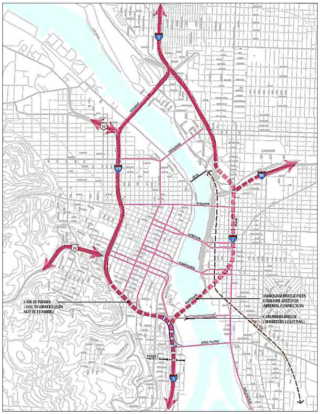
The year was 2005, and the tone was urgent.
“Clearly, the I-5/405 Freeway Loop needs immediate attention.”
“To keep the I-5/405 Freeway Loop viable, planning and design for improvements must begin now.”
“We are at a very critical juncture. It’s time to move forward.”
The blue ribbon Freeway Loop Advisory Group (FLAG), appointed by former Portland Mayor Vera Katz and Oregon Department of Transportation Director Bruce Warner, was tasked with finding strategies to surmount the increasingly apparent flaws of the inner-city’s post-World-War II freeway plan. The FLAG included representatives from ODOT, the Portland Business Alliance, the Oregon Trucking Association, TriMet, the Oregon Transportation Commission, and Metro.
This group—hardly a bunch of radicals— noted that “freeway construction, combined with urban renewal projects, divided and destroyed neighborhoods in the name of a modern transportation system.” To begin to remedy this, and to insure a prosperous future for our region, they proposed the very bold plan of removing the Marquam Bridge and relocating the southern and eastern portions of the Freeway Loop into tunnels. “Complex transportation projects can take at least 15 years from initiation to completion,” which is why they urged the planning to begin “now” (the study tends to bold the twelve occurrences of the word “now”).
Sixteen years later, where has our boldness gone?
Advertisement
With federal money finally available to correct, or at least mitigate, the worst mistakes of the freeway-building era, has our vision and urgency shrunken to the point that ODOT’s only proposal to fix the Freeway Loop is a misguided plan to widen I-5 through Albina, a community still hurting from the original freeway placement?
President Biden’s transportation plan notes that “too often, past transportation investments divided communities.” I say, let’s apply for federal money to actually reconnect our city.
The FLAG study was followed ten years later by the West Quadrant Plan. The West Quadrant Plan was more of a roadmap for future growth on the westside, and it replaced talk of tunnels with the more feasible idea of capping sections of I-405.
Both plans identified some of the same problem areas and traffic patterns which continue to create barriers in the city. Here are a few:
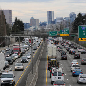
The southernmost stretch of I-405, between the Ross Island Bridge and Highway 26W interchanges creates a
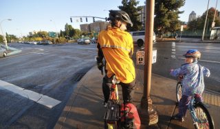
(Photo: J. Maus/BikePortland)
“significant barrier between the downtown and PSU area north of the freeway and the South Portland hills, particularly for pedestrians and cyclists. Growth in traffic … has also exposed the limitation in the freeway design, leading to congestion, short weaves and overreliance on local (and previously local) streets to carry regional traffic … ODOT identifies this stretch of the freeway system as being in the top tier in terms of number and severity of crashes.” (West Quadrant Plan)
I wish I could edit their quote and substitute “Southwest Corridor” for “South Portland hills,” because I-405 and the surface roads of 26W create an almost impenetrable divide between the entire area of southwest Portland and the central city, especially for people walking and biking.
Access to the river should be improved.
“The current Freeway Loop presents a number of barriers to river access from adjacent districts. These barriers include the long distances between crossings, the quality of the crossings, and freeway visual and noise impacts. Future project alternatives should include improved access and reduction in these barriers.” (FLAG)
The Freeway Loop hinders high-quality urban development.
“Portland is well known for its innovative urban planning and pedestrian friendly developments. But the Freeway Loop creates barriers that hinder commercial, recreational, and residential development and limits access to the river.” (FLAG)
The Freeway Loop Study mentions that there are 45 on- and off-ramps in the 6.5 loop. That is about seven dangerous, surface-street-disrupting intersections per mile. If some of them were removed it would improve safety on the surface streets and make designing bike lanes simpler. (Do we really need westbound exits off I-405 to SW 12th, 6th and 4th Avenues?)
Portland does not have a shortage of projects or plans which can begin to remedy the historic division and destruction of neighborhoods brought by the Freeway Loop. To this day, the Loop creates barriers which inhibit the flourishing of our city. The Biden infrastructure plan includes billions of dollars “for a new program that will reconnect neighborhoods cut off by historic investments.” This federal money might be a once in a lifetime opportunity. We should not squander it by being too timid.

— Lisa Caballero, lisacaballero853@gmail.com
— Get our headlines delivered to your inbox.
— Support this independent community media outlet with a one-time contribution or monthly subscription.


Thanks for reading.
BikePortland has served this community with independent community journalism since 2005. We rely on subscriptions from readers like you to survive. Your financial support is vital in keeping this valuable resource alive and well.
Please subscribe today to strengthen and expand our work.
Sadly, in today’s Land of the Free, political division and outright meanness stymies any attempt to move forward. Plus, if the GOP gets back control of Congress next year, all of Biden’s programs will come to a screeching halt.
If a single Democratic senator switched parties to Republican, as both guy from WV and a woman from Arizona have already threatened to do, then the Republicans would take control of the Senate immediately and Biden’s agenda would come to a screeching halt. Whichever party holds a majority controls the committees and thus procedures and legislation. Of course the Republicans couldn’t pass anything either as the House would block it, nor would they have the votes to overcome a presidential veto, so we would be back to a stalemate.
Which people in power in Oregon passed a tax on most bicycles sold in Oregon?
Didn’t those same legislators raise the freeway speed limit to 75 mph? Allow for concealed handguns? Push for the I-5 Rose Quarter project and now the new Columbia Crossing bridge?
Very progressive.
I believe the south Portland hills and Albina are poster children for “neighborhoods cut off by historic investments.” Really makes the 2005 study an interesting data point in our priorities.
Parkrose and Wilkes in East Portland also got sliced and diced by freeway projects, and probably others along the Banfield & I-205.
albina and lair hill/sw portland should both be reconnected to the greater community; i have talked to lisa about terminal city in nyc (https://en.wikipedia.org/wiki/Terminal_City_(Manhattan)). it shows a special lack of vision to ignore something with potential for restorative justice AND long-term profits.
speaking of ‘sw corridors,’ i will note that the late rail project missed an opportunity to fix some of the issues in the 405/downtown connection, and simply flew over them (pg 93 of final design report). anecdotally, pbot had requested no new level crossings to avoid complicating existing. true or not, NO project of this size accepting status quo instead of addressing these problems should be acceptable ever again. BASTA!
I was an ‘intern’ at the PBOT transportation planning section in 2005 under Steve Iwata – his solution at that time was to make I-405 one-way in a counter-clockwise direction and close off exits accordingly, to essentially make it one huge roundabout. According to our computer models, such a solution would effectively double the highway’s capacity and vastly reduce crashes, all without building anything. Because it was a cheap no-build solution, it was rejected.
So, convert the corresponding SB lanes of I-5 to NB? I’m curious about how that would work with the Marquam bridge.
If I remember correctly (16 years ago), there would be a separation of traffic where northbound I-5 comes into I-405 in Lair Hill: Those going on I-5 North past the Rose Quarter would use one deck, and the I-84 exiters would use the other deck, but I don’t remember which was which.
Karstan, the Loop Study I link to outlines three approaches: moderate, revolutionary and radical. The one-way loop is the “revolutionary” approach and they include a summary of what would change.
The “moderate” is also interesting in that it more specifically mentions individual problem spots that needed attention.
The tunnel was the “radical” approach. The study is only 14 pages long, it was sad to see how many of the problems they describe we still have, only worse.
The literally radical approach would look at the root of the problem (radical (adj.): “originating in the root or ground;”).
The root of the problem is the freeways themselves, so the real radical solution would be something like getting rid of all freeways in Portland (see: Vancouver BC). Or a compromise could be removing east-side I-5 south of I-84 as well as removing the Marquam Bridge (or mayhaps keep part of it, as a monument to the monstrosity of 1950’s thinking). Don’t stick it in a tunnel, just take it down. That’d be rad (literally).
I believe it would basically require one deck of both the Marquam and Fremont to be a “through deck”. Example: if you are coming from 26 eastbound and want to get to I-84, you go on to the upper deck. I-5 northbound traffic would go on the lower deck. I wouldn’t exactly consider this a “no-build” option, because major ramp reconfiguration would be needed. It’s not as crazy as burying I-5, but I’d rather just see them tear down the Marquam and I-5 on the east bank. Make I-405 into I-5, add congestion tolling, and be done with it.
Even better, as I’ve suggested many times: remove the Eastbank Freeway and reroute I-5 down the I-405 corridor, also capping it around downtown. The section of I-5 north from I-84 to the Fremont becomes another mile of I-84, the section south to (and including!) the Marquam is gloriously demolished, opening up the riverfront and greatly quieting the Esplanade.
The 2008 Crash and the decline in traffic over the next several years put a stop to lots of projects and planning. I think there was even talk for a while that traffic would decline because the next generation (Millenial or Y or?) didn’t want cars or traditional suburban homes.
Tunneling the freeway sections shown above could easily cost $10 billion. Our very own Big Dig.
So what? The CRC project was going to cost up to $5 billion, and that was taken very seriously and almost happened. $10 billion or even $20 billion to bury the freeway would be a worthy investment. Think about all the land that would be uncovered and available for development. A lot of the cost could be recouped in that way.
Also, most of the problems with the Big Dig had to do with it being a cut and cover tunnel with tons of vents and shafts and whatnot. Deep bore tunnels have generally been much more successful and cost-effective. Even the Seattle highway tunnel, which had some problems at the beginning, went just fine after the first year or two. And their recent deep bored light rail tunnels actually came in under budget.
The Seattle tunnel project came in way over budget, was years behind schedule, and their tunnel only has 4 lanes. We would need at least double that to match existing capacity, and our tunnels would require significantly more access ramps (unless we just want to permanently close all rams from the Morrison and the inner-east side). The light rail tunnels in Seattle are not really comparable (we would also be tunneling under a river).
ODOT doesn’t have $10 billion dollars, so how would we fund this? The Seattle project is also a great example here. They have had to greatly reduce the tolls and expected toll revenue, because drivers were just taking surface streets instead (also because they lost many of the ramps they used to have on the viaduct).
Portland should follow the example of Vancouver BC and end the interstates on the outskirts of town. It would deter thru traffic and disperse the city traffic. Restore route 99 to its former glory!
Typically Federal DOT ‘solutions’ only pay for “expansion” of capacity and not reduction of capacity…BUT there may be a 1 to 2 year window here under the Biden period if Oregon and Portland can get a collective vision, local match and get things rolling in DC to do a “restorative” project…assuming Congress pays ball and D Senators don’t switch to the R party.
In most European cities the highways are underground in tunnels with very few entrances and exits in the urban area; that is a model to strive for, as the most dangerous surface streets in Portland are in the vicinity of the highway entrances and exits.