Welcome to a new thing we call Bike Thru (yes I’m aware I spelled it “Through” in the video). The idea is to share Portland’s cycling infrastructure via video with narration to share a bit more information about the facility.
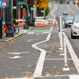
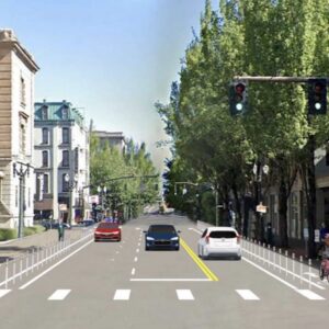
The first one I’ve tried is on the new(ish) bike lanes on Broadway between Hoyt and Oak. We first shared photos and impressions of these lanes in late November 2020. Now that (most of) the leaves have been swept up the curb ramp work is done, I figured it was time to take a second look.
Advertisement
To refresh, this $1.9 million project was part of PBOT’s effort to improve biking and transit service in the central city.
Check out the video and let me know what you think. If this format works, we can do more of them for infrastructure all over the city.
Do you ride here? If so, we’d love to hear what you think of these bike lanes. Are they working for you? How does that merge section feel?
— Jonathan Maus: (503) 706-8804, @jonathan_maus on Twitter and jonathan@bikeportland.org
— Get our headlines delivered to your inbox.
— Support this independent community media outlet with a one-time contribution or monthly subscription.


Thanks for reading.
BikePortland has served this community with independent community journalism since 2005. We rely on subscriptions from readers like you to survive. Your financial support is vital in keeping this valuable resource alive and well.
Please subscribe today to strengthen and expand our work.
Love this format for explaining the new bike infrastructure. Much easier to understand than photos.
Thanks Jack! Is there any other piece of infrastructure you think would make a good candidate for one of these? I’ll probably do the new striping on Hawthorne/Madison next.
Agreed with Jack, this is a great format. I’d love to see one of the new Flanders Crossing bridge including the surrounding approaches once it opens.
I think there’s a lot of potential for this video format. Not only in the infrastructure heavy areas (although I do hope you continue to highlight that), but also in showing some of the neighborhood greenways, or useful routes through otherwise tricky areas.
A few ideas (in no particular order):
– Routes over the west hills (via the Zoo, Multnomah Village, etc.)
– Better Naito (once that’s been built out a little more)
– Some of the north/south bikeways (20s, 50s, 70s)
A few things that I would like to see is more commentary about sections that don’t work well, or where riders should use caution. I think a quick overview of the route on something like Google Earth might help give some context for people who aren’t familiar with Portland.
I think of myself as one of the “interested, but concerned” category of people. I find a few routes that I’m comfortable with, or will research a route in advance, but I don’t tend to go exploring for new routes or connections, so videos like these are very helpful for me.
Keep it up!
Wow! Nice facility, a bit like those in DC and Chicago.
Depressing city though, not the Broadway I used to bike daily from Sullivan’s Gulch to the Portlandia Building – more graffiti, more boarded up windows. And the tents are after my time. Same homeless. Reminds me of Pittsburgh in the 80s.
I found the subtitles very distracting from the video feed.
Thanks for the feedback David. This was my first attempt at using subtitles and forcing them as a default… mostly for folks that have autoplay on and maybe listen without sound on. Also for folks that can read but don’t hear so well (or at all of course) But I hear you about the distraction!
I appreciated the subtitles FWIW
I also liked the subtitles. And it is possible to turn them off — just click the CC button within the YouTube video.
Thank you, that’s a very helpful suggestion. It should have been obvious but it wasn’t to me.
I liked the format but felt it was missing some crucial details. The Hoyt intersection was a big source of right-hook crashes heading southbound and that was eliminated with a diverter installed for Hoyt westbound. PBOT also worked with TriMet to reroute Line 17 off Broadway to the transit mall to eliminate most bus-bike conflicts here. Also, the new signal at Flanders was passed without even a mention. It’s a separate project but it finally allows safe crossings for bikes and peds on Flanders as part of the greenway.
Glad you liked the format. I realize a lot was missing. This was my first try. I’ll figure out how to incorporate more info in the next one. Or I could just make the whole thing a few minutes longer. I was trying to be brief but yes it could have had a lot more detail. Thanks.
Great video! Like someone else mentioned, I would’ve preferred a longer, more detailed video, if possible. This might be semi-unrelated, and I know it’s out of the scope of this video or site, but it would be awesome if there were a detailed map of bike facilities with a StreetView-esque perspective available, or at least a video catalog of facilities like this.
I hope you do have a way for readers to either turn off the subtitles or edit the misinterpretations out of them. I’d offer my services, but I don’t reliably have the time.
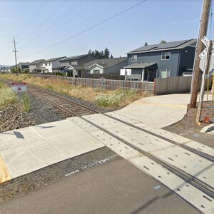
That’s a perfect way to review a project–the view of someone using it with commentary to guide the viewer. It reminds me of one you published a while ago of someone in a wheelchair trying to open a gate at a light rail track crossing (great for showing how what works for one user doesn’t work for another), of your ride across the 205 bridge, etc.
When a project is done well, I feel like the designers must have spent time at the site–first doing a “before” video (at least in their heads) similar to yours, describing to themselves (or hearing from users) what needs fixing and how, then visualizing potential designs from the standpoint of a user as they move through it. When a project is a failure, I feel like it was designed on paper with no visualizing of how a user would experience the proposed design.
I used to work at the customs house. Tons of close calls coming off the bridge with traffic merging. Not as many close calls heading home on Broadway but the road was always cramped with parked cars and traffic. It looks like they almost care about us now :p
I like this format for showing off new infrastructure. It might also be cool to do something similar for places where the current infrastructure fails. I also think it would be interesting to have a traffic engineer explaining why certain decisions were made at certain points like why they chose to do that crossover with the white teeth as opposed to something else. Nice job!
Just want to add my support for this format! It’s great to get the narration highlighting all the elements of the project and how it feels and functions.
Also thanks for calling out the pavement condition crossing Burnside, that’s definitely something that is badly needed.