
(Photos: Jonathan Maus/BikePortland)
When it comes to bicycling, Broadway might be the most important street in Portland. It delivers people from some of our busiest bikeways (Williams, Tillamook, Interstate, Broadway Bridge) and most bike-oriented neighborhoods to the heart of our “living room” (Pioneer Square), cultural district, and one of the largest universities in Oregon.
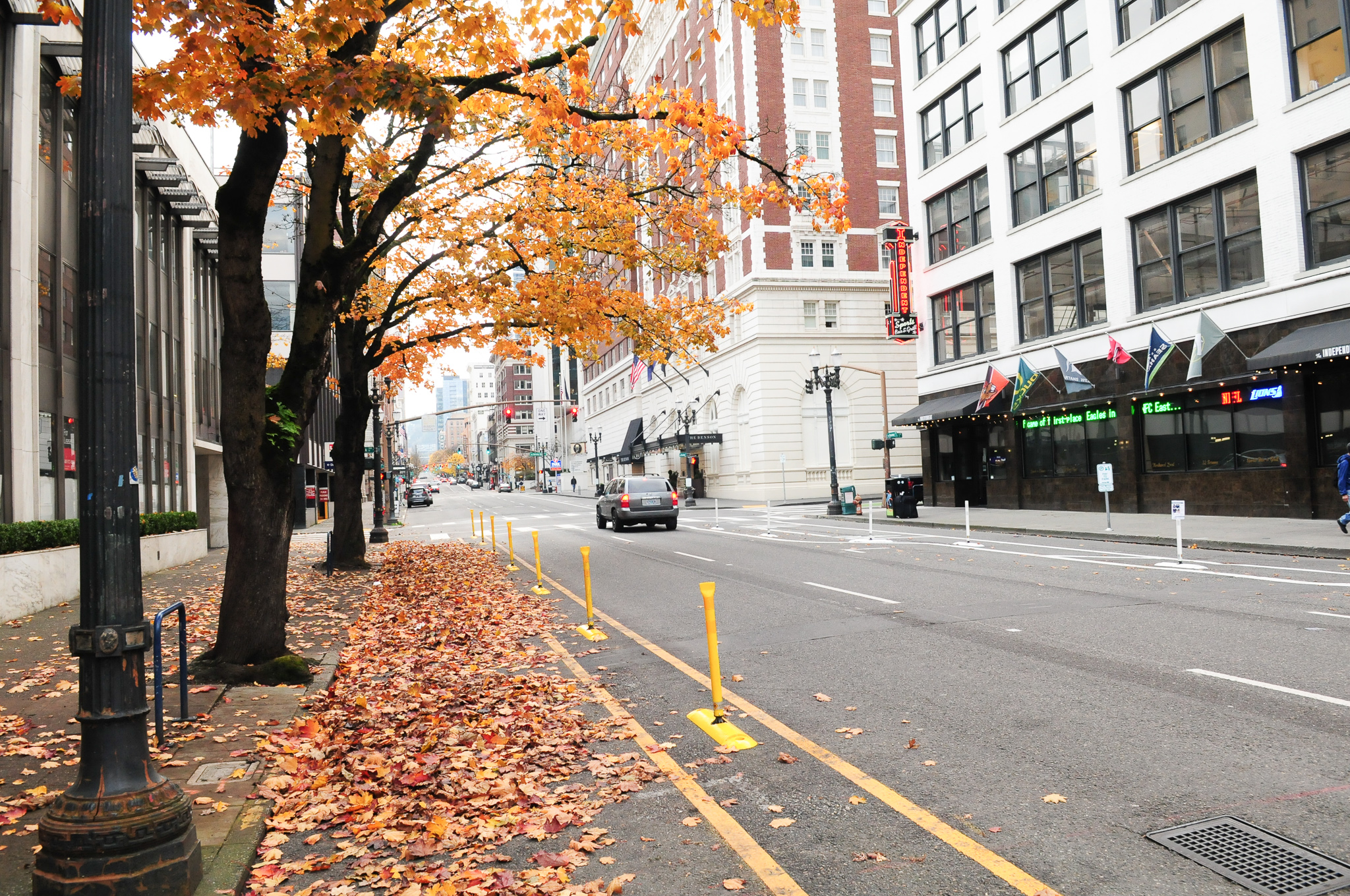
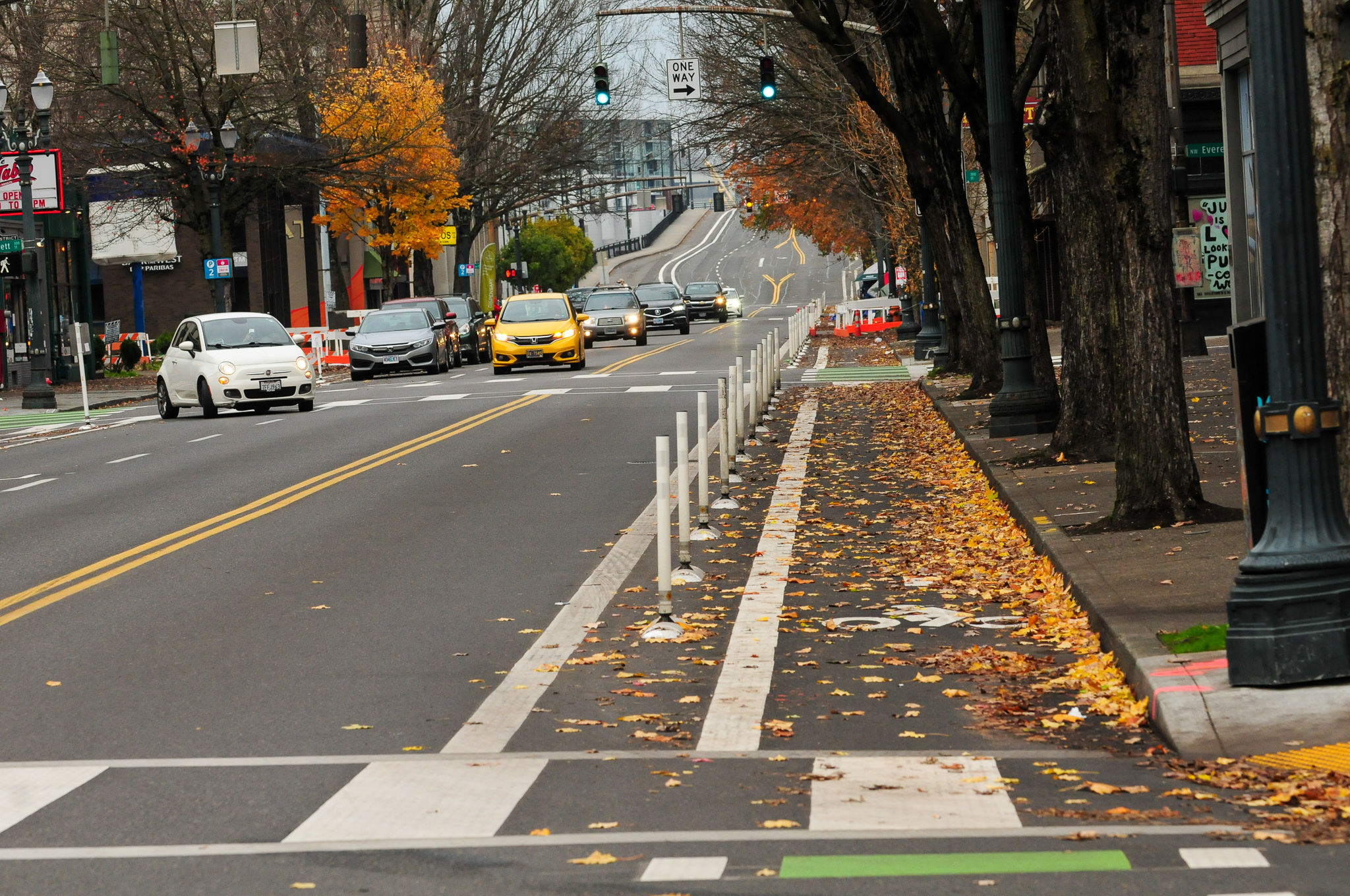
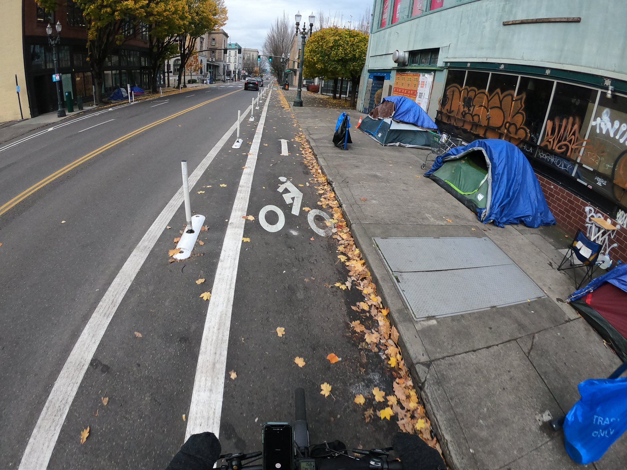
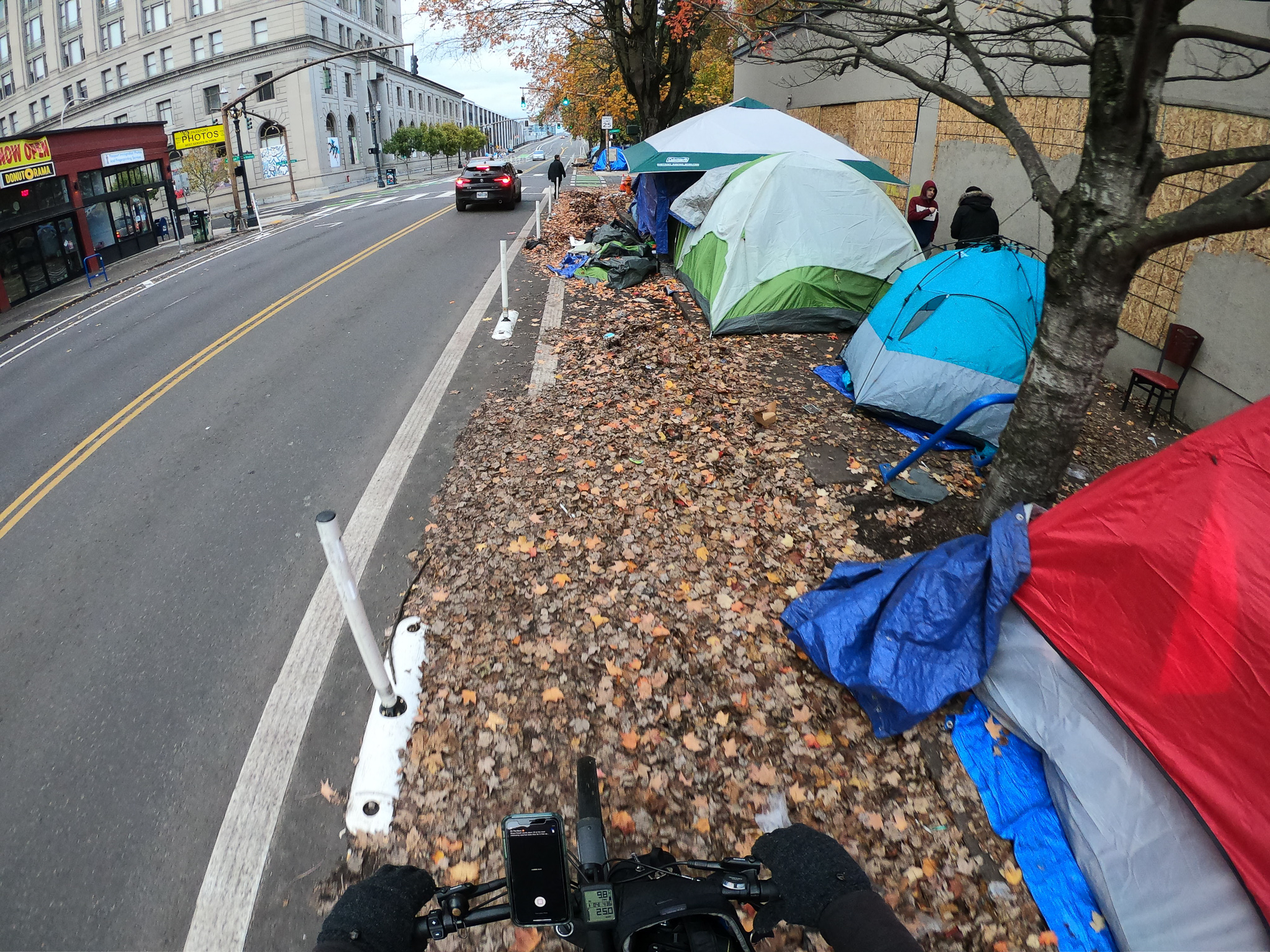
Unfortunately Broadway’s bikeway has never lived up to its potential. A new project from the Portland Bureau of Transportation has taken the biggest step forward for cycling access on Broadway since former Mayor Sam Adams made it the site of our first protected bike lane over a decade ago. As I shared last month, PBOT has reconfigured the lanes on Broadway between Hoyt and Oak to create more space for cycling. With the project completed (except for a few corners), I took a closer look over the weekend.
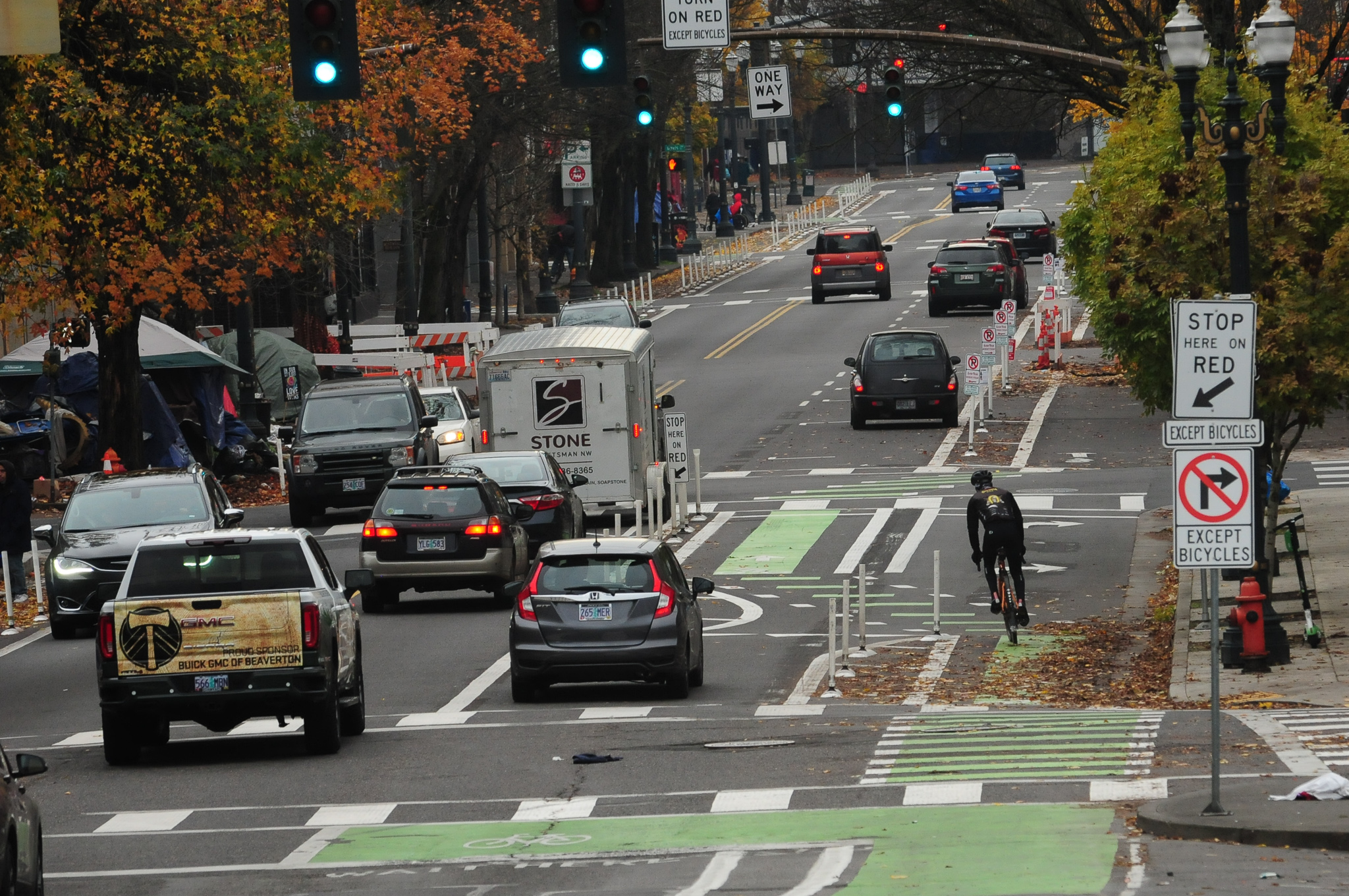
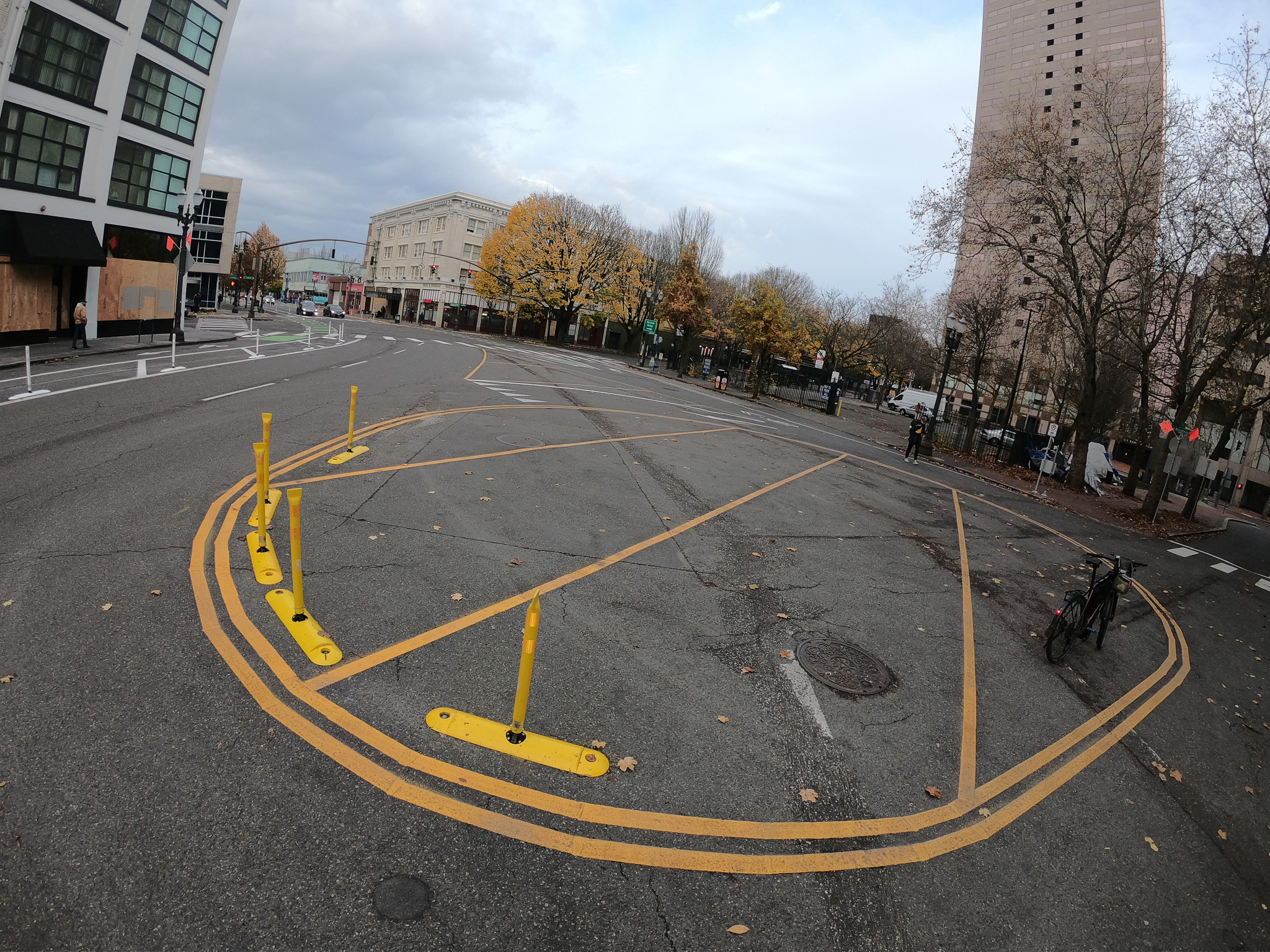
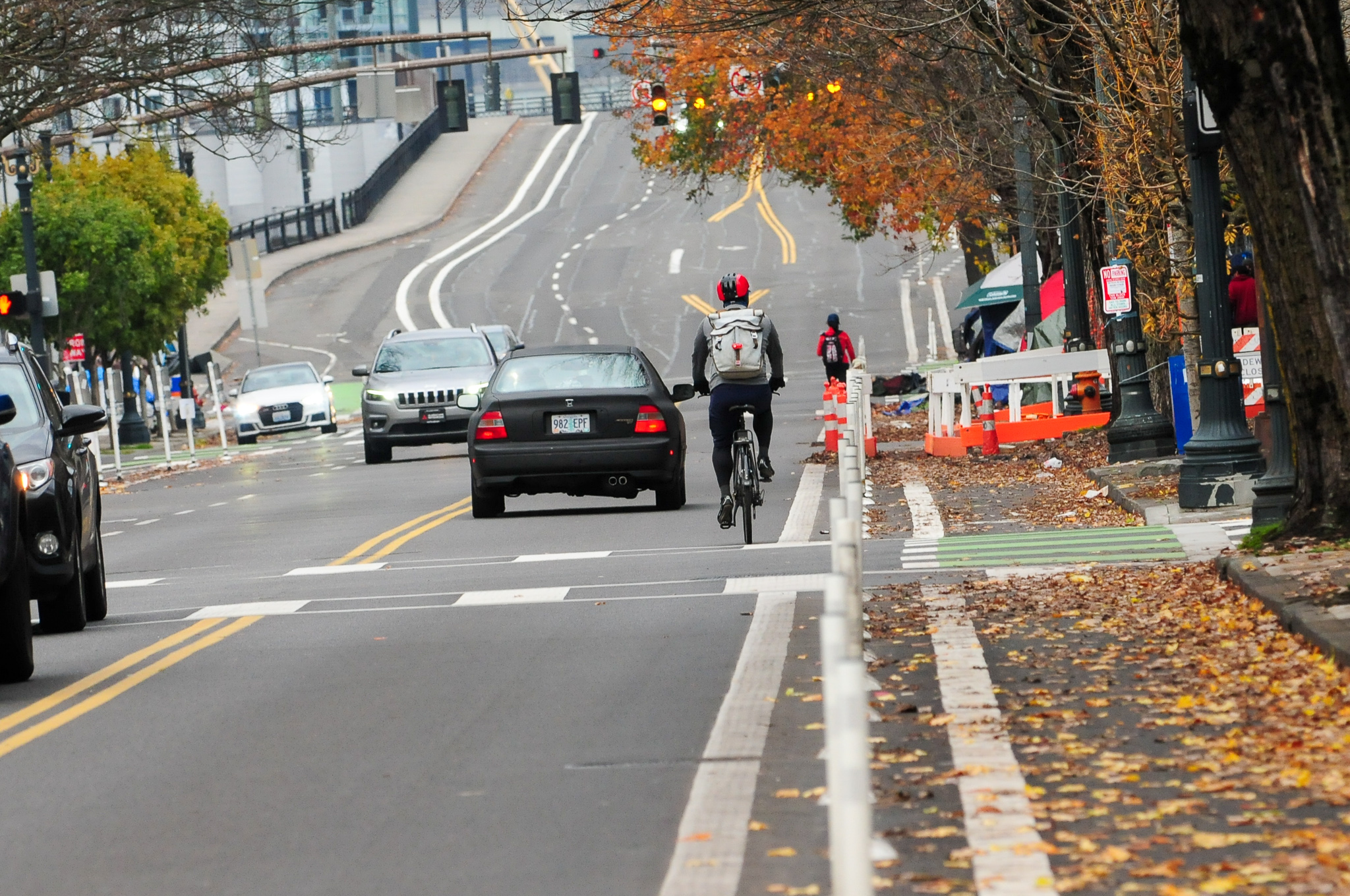
The topline summary is that there’s a new protected bike lane on both sides of Broadway between Hoyt and Oak. PBOT has also created a roundabout in the vast expanse of the Burnside/Broadway/Ankeny intersection (taking us one step closer to a future public plaza space).
If you’re headed south into downtown on the Broadway Bridge ramp (which was restriped to handle more bike traffic in 2013), the first change you’ll notice is that car and truck users can no longer turn right onto NW Hoyt (see photos below). Portlanders spilled lots of blood at this intersection before PBOT took this much-needed step.

Advertisement
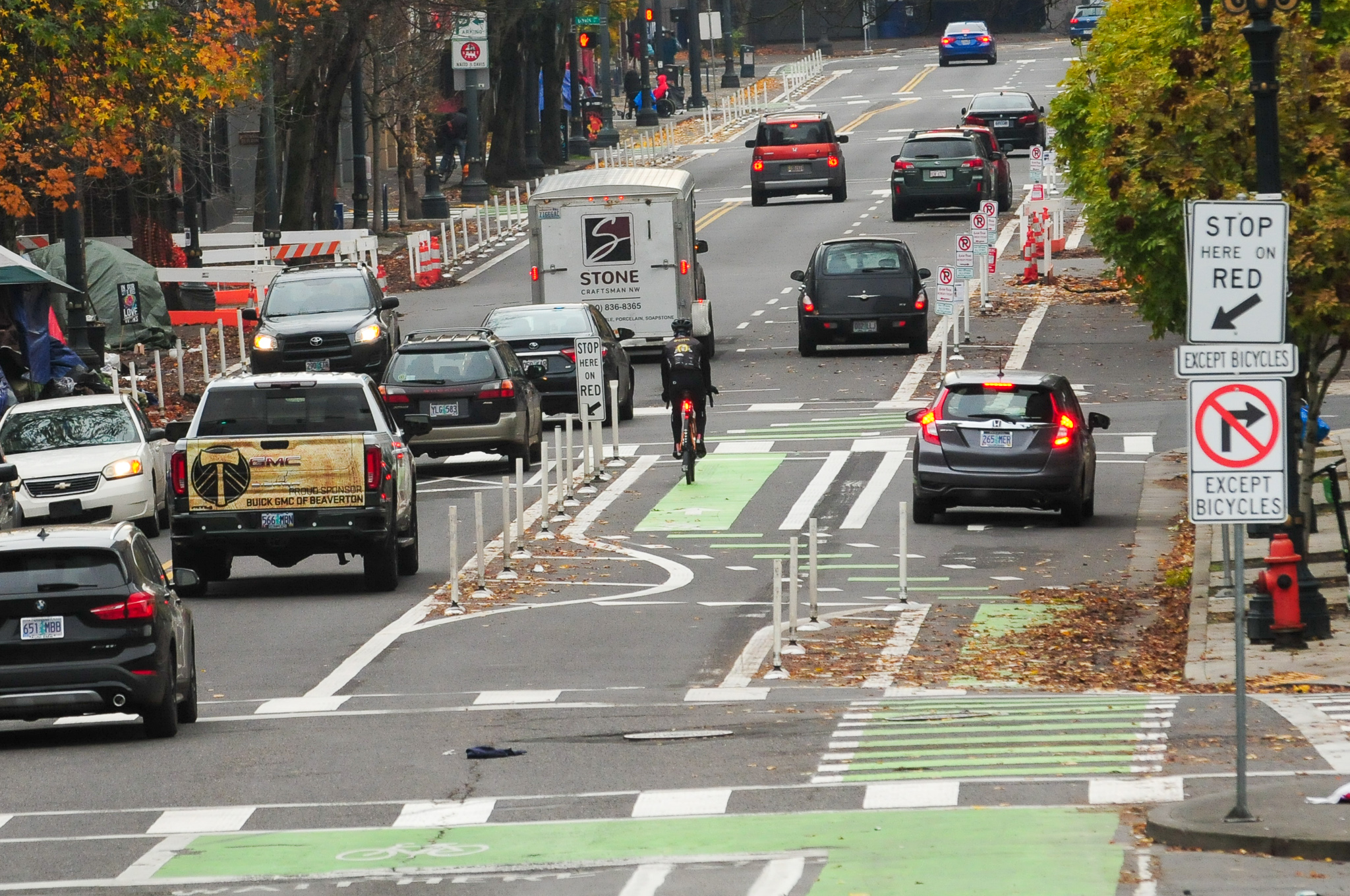
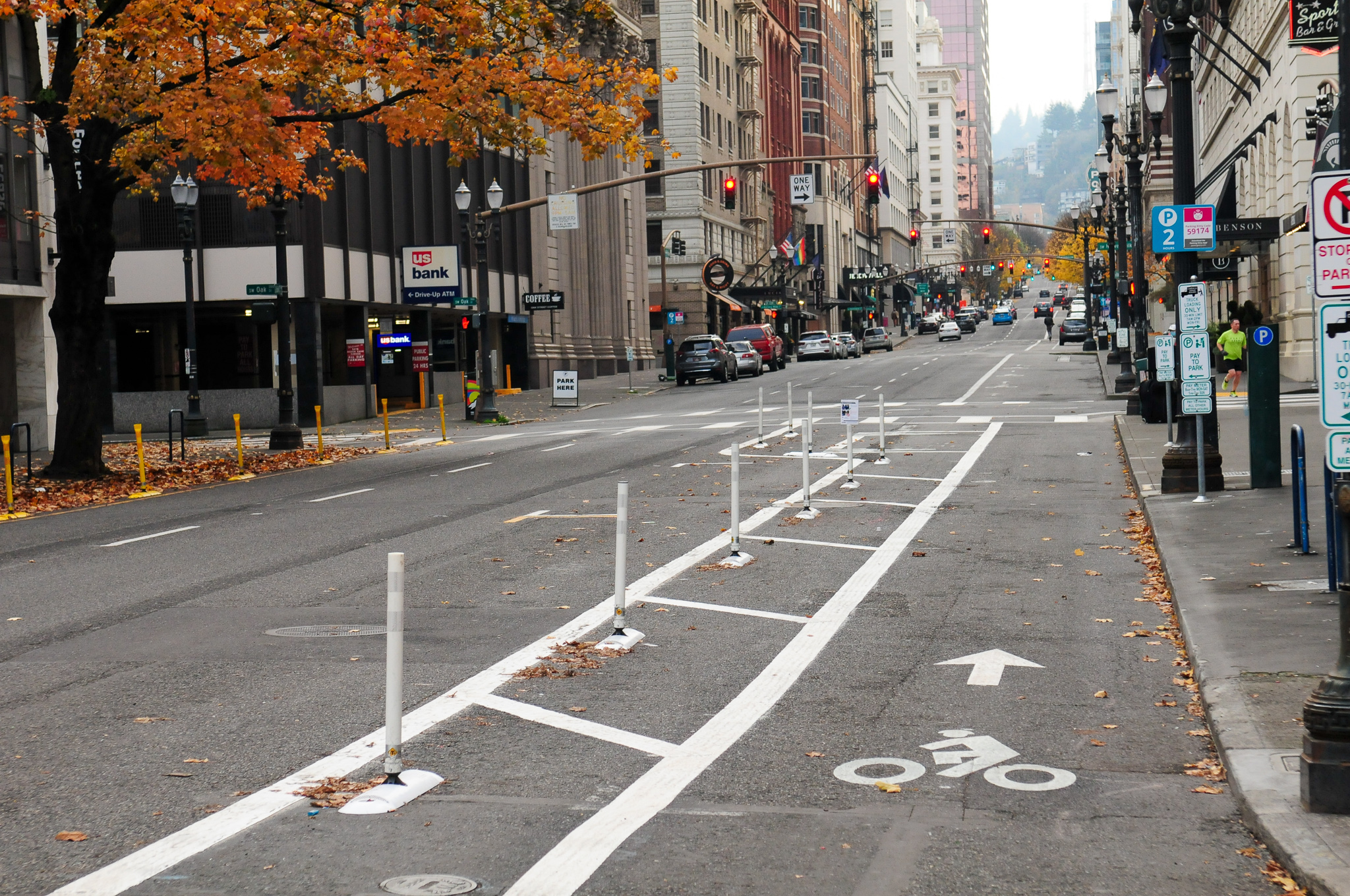
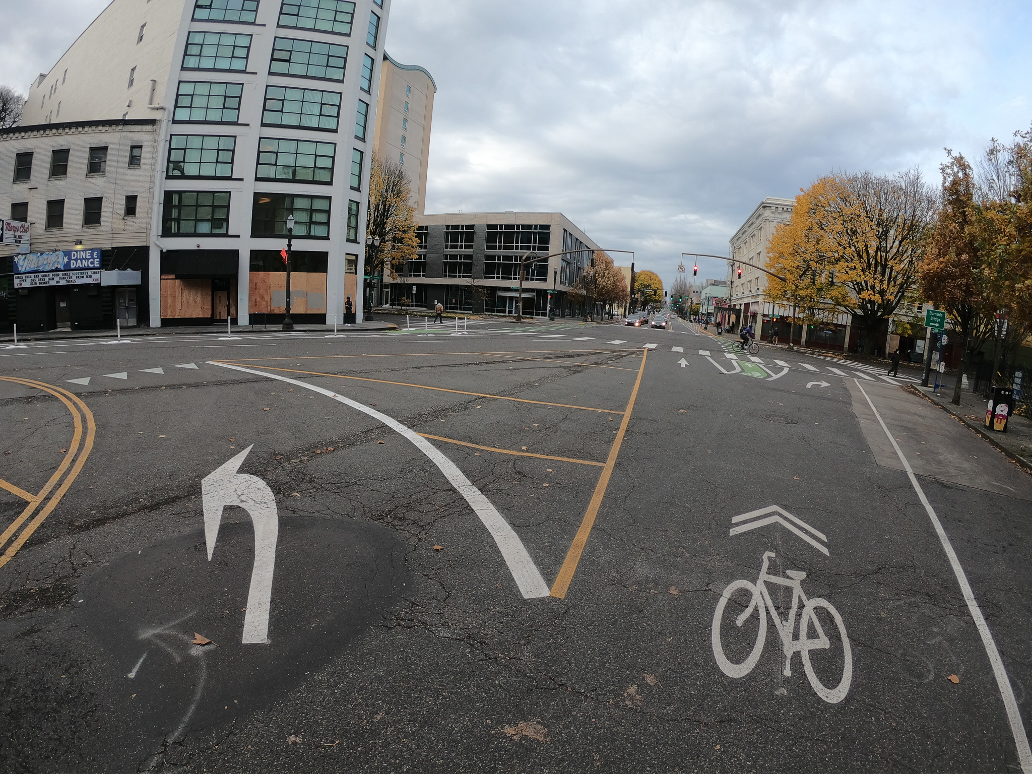
The new southbound bike lane is curbside, except for the block between Hoyt and Glisan. PBOT introduced a weave between the bike-only lane and the adjacent general travel lane in order to facilitate right turns at Glisan. In a green-colored lane protected by plastic wands and curbs, bike lane users merge to the left before the Glisan intersection. The thinking here is that a mid-block merge that can be controlled with paint and plastic is better (safer and less expensive than a bike-only signal) than doing it at the intersection. Bike lane users have the priority (based on shark teeth markings pointing at the other lane). From my observations, driver speeds are pretty low thanks to the narrow lane and the merge seems to work OK.


Advertisement
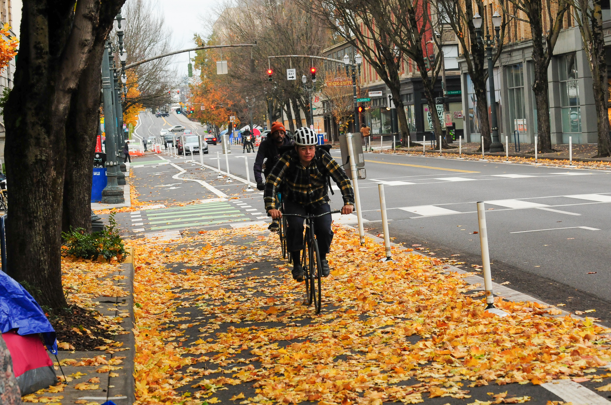


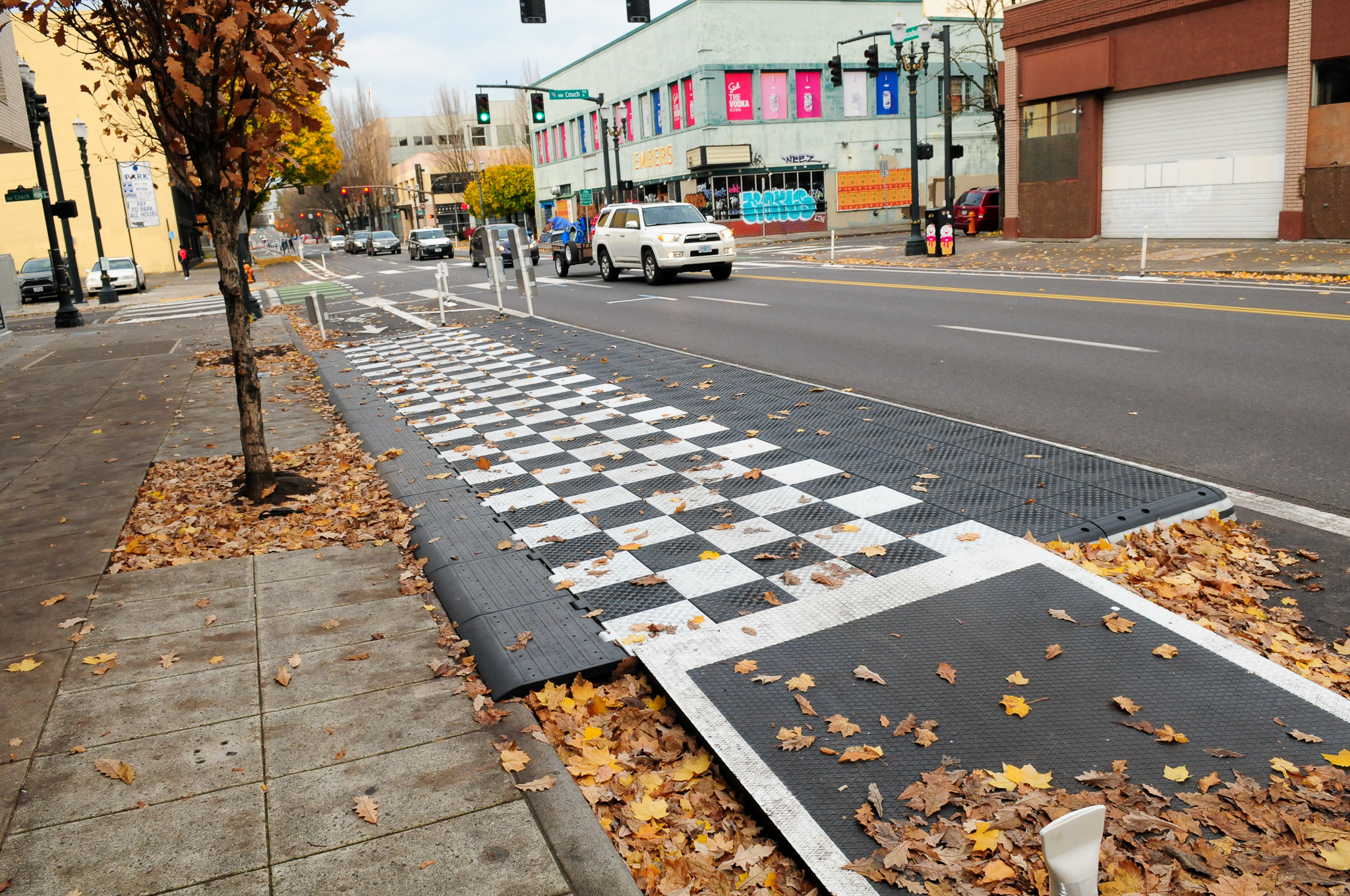

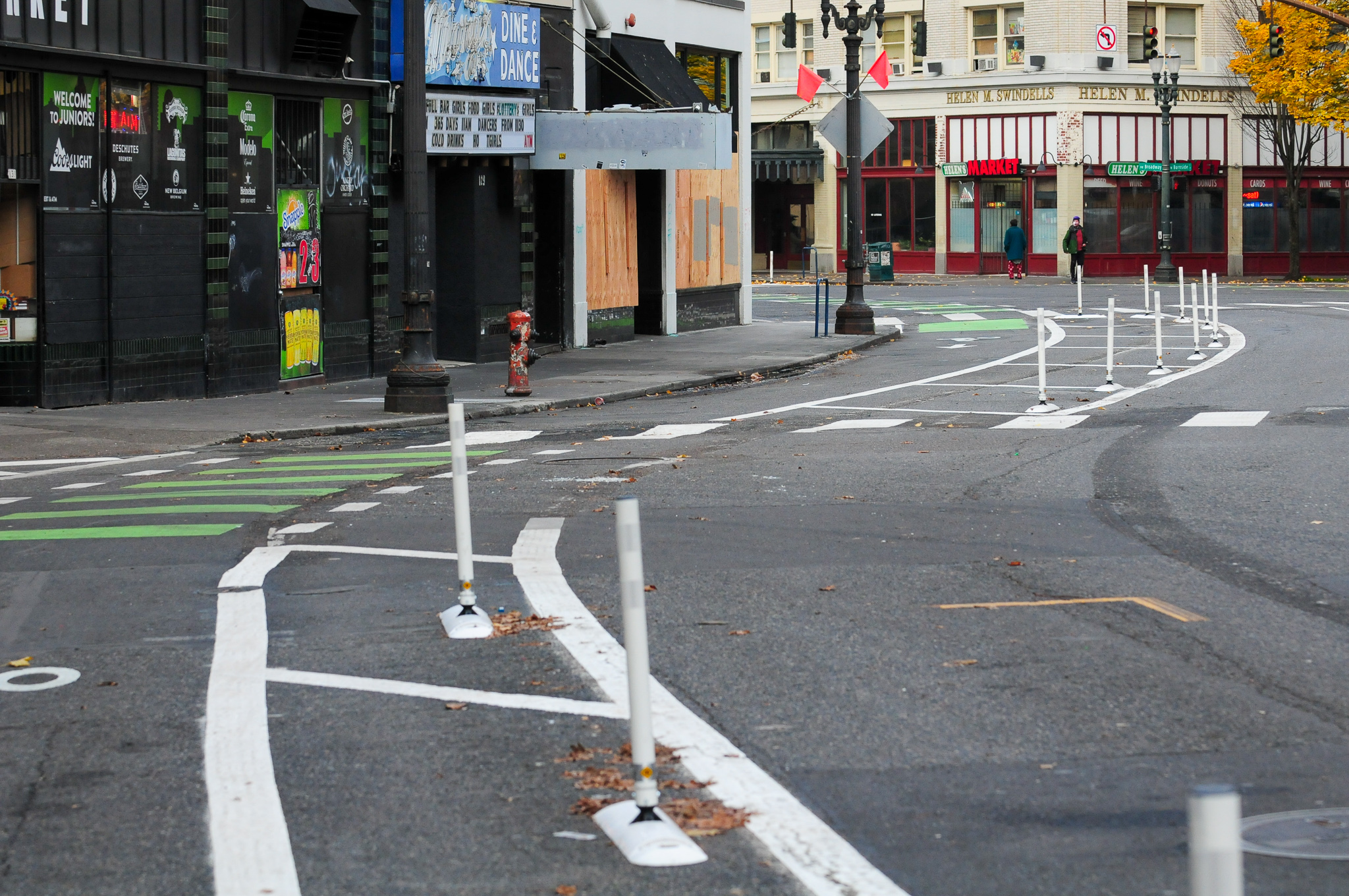
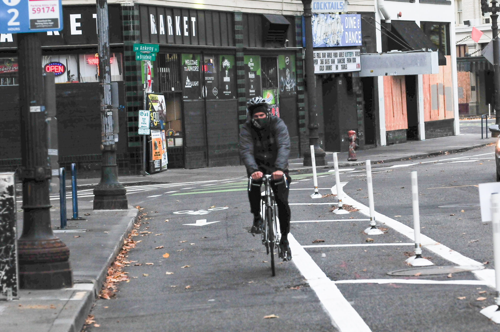
After Glisan the bike lane goes back to curbside and continues to Burnside without a hitch. There’s a new floating bus island in front of Central City Concern just before Burnside that’s the same product PBOT recently installed on NW 18th and 19th. North of Burnside to Oak, the bike lane feels luxuriously wide — so much so that I’m afraid the old unprotected, door-zone bike lane between Oak and Clay (where the PSU protected lane starts up) will feel even more narrow and stressful.


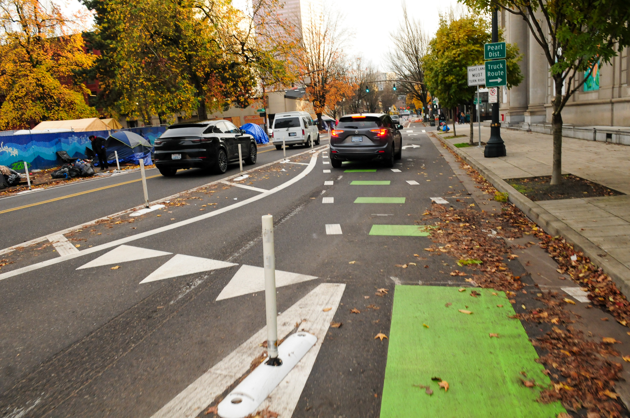
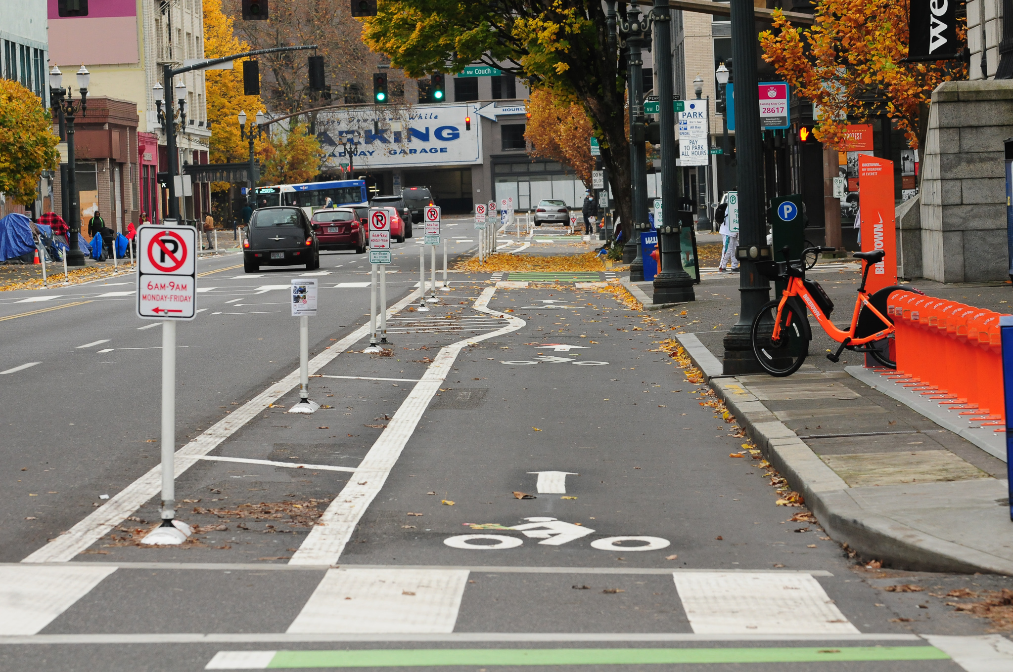
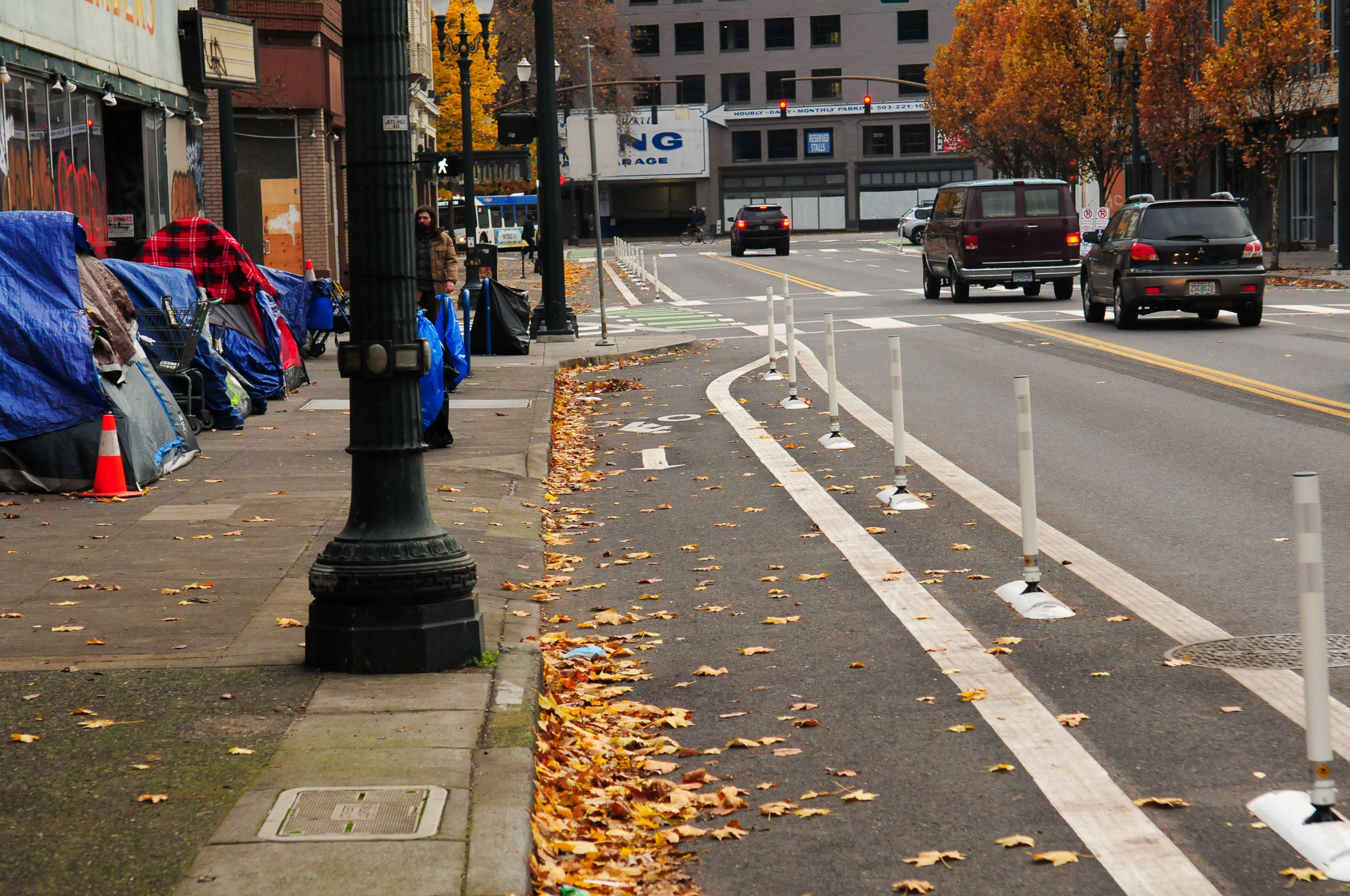
Northbound from Oak PBOT has installed a contra-flow bike lane that rolls into the new roundabout at Ankeny. The roundabout is the only section of the new bikeway where bicycle riders don’t have protection. The roundabout is marked with sharrows and is shared with TriMet bus operators and other drivers.


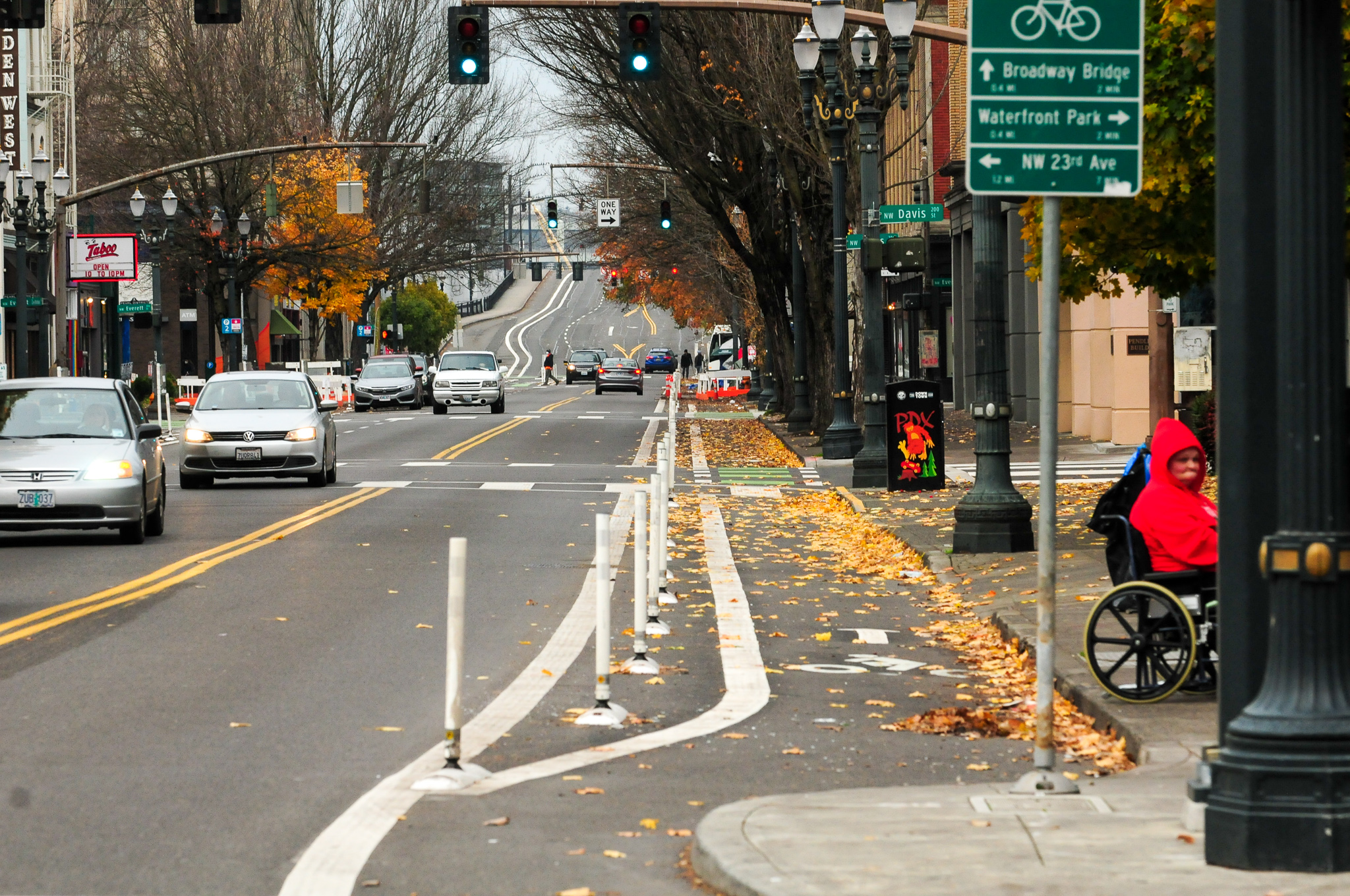
The bike lane picks up again to cross Burnside and it’s protected with a mix of paint and plastic wands and curbs all the way back to Hoyt where it connects to the existing bike lane up to the Broadway Bridge.

Advertisement


It’s exciting to have this new protected space on such a marquee bikeway; but my glee was tempered by a few things.
Advertisement
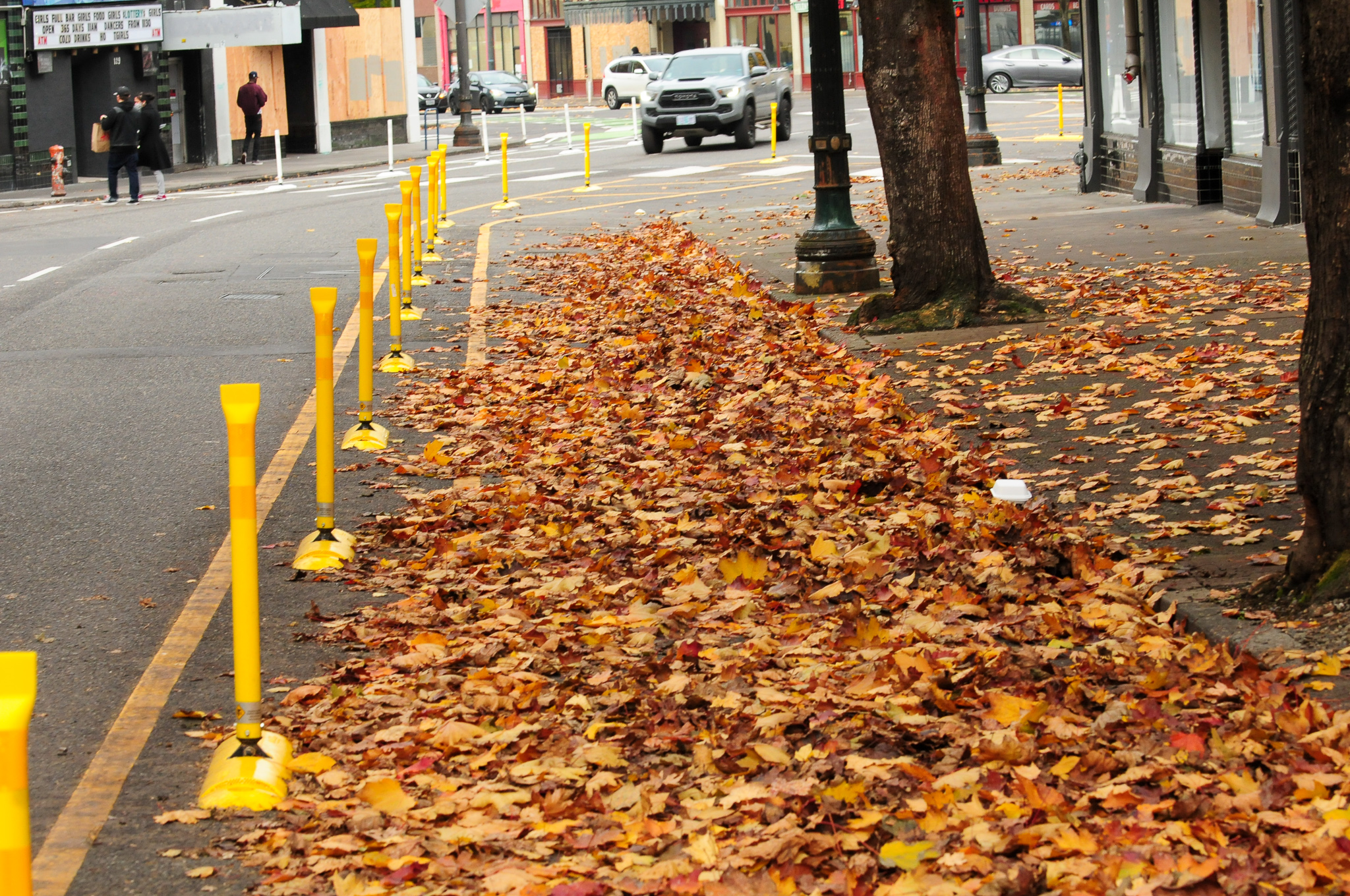
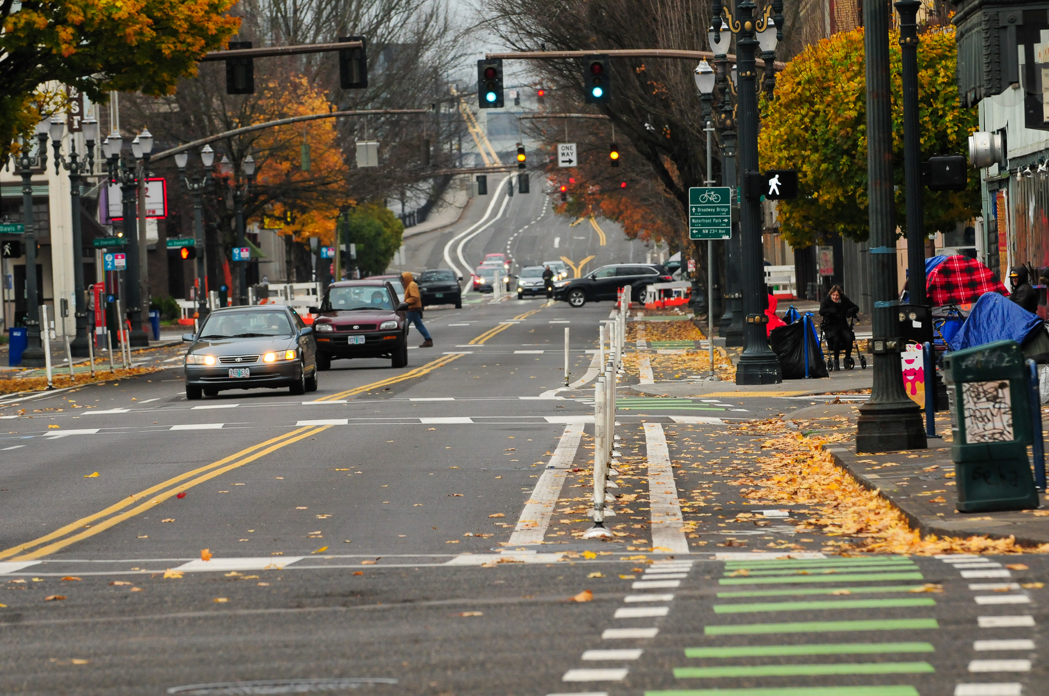
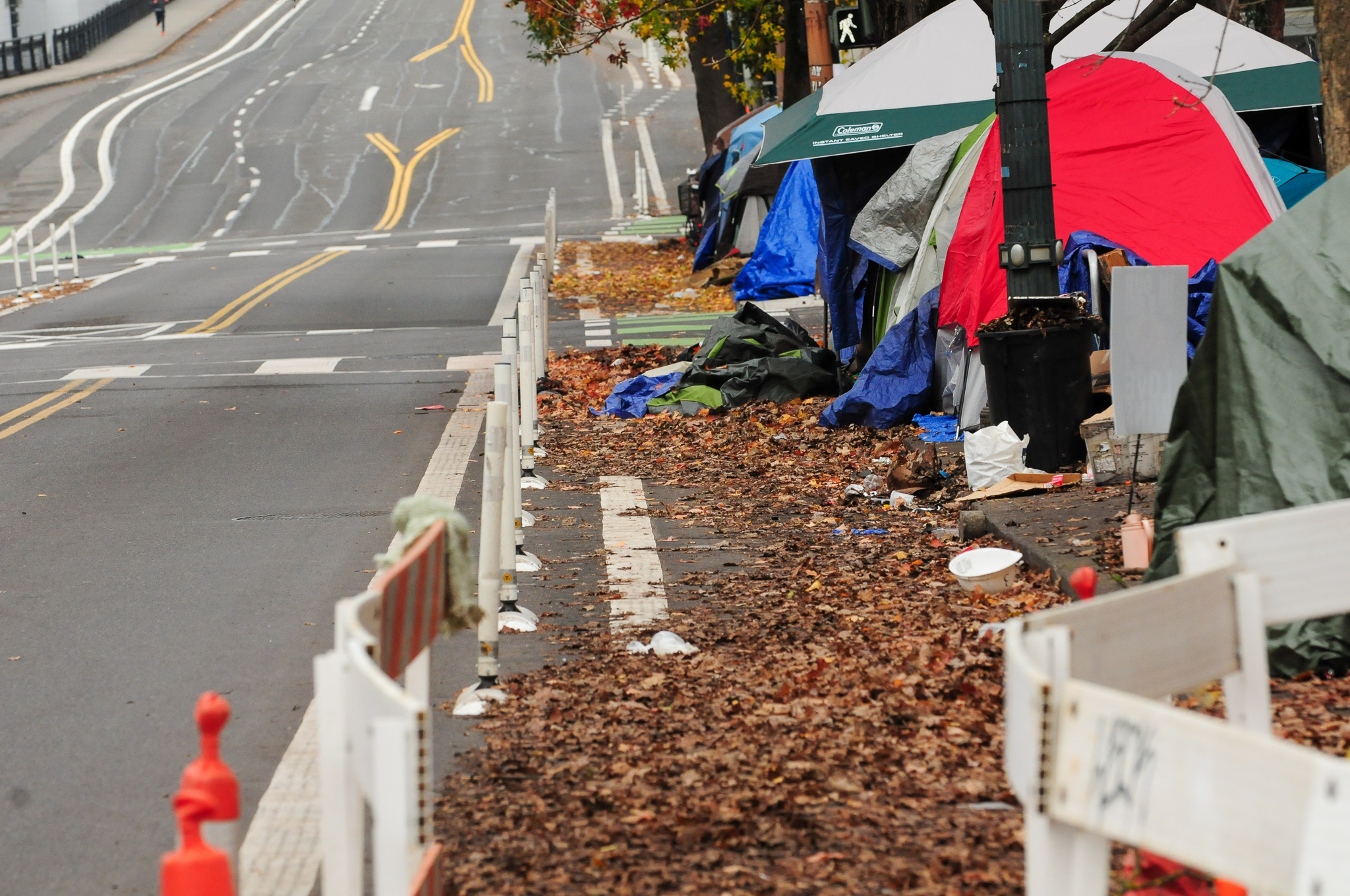
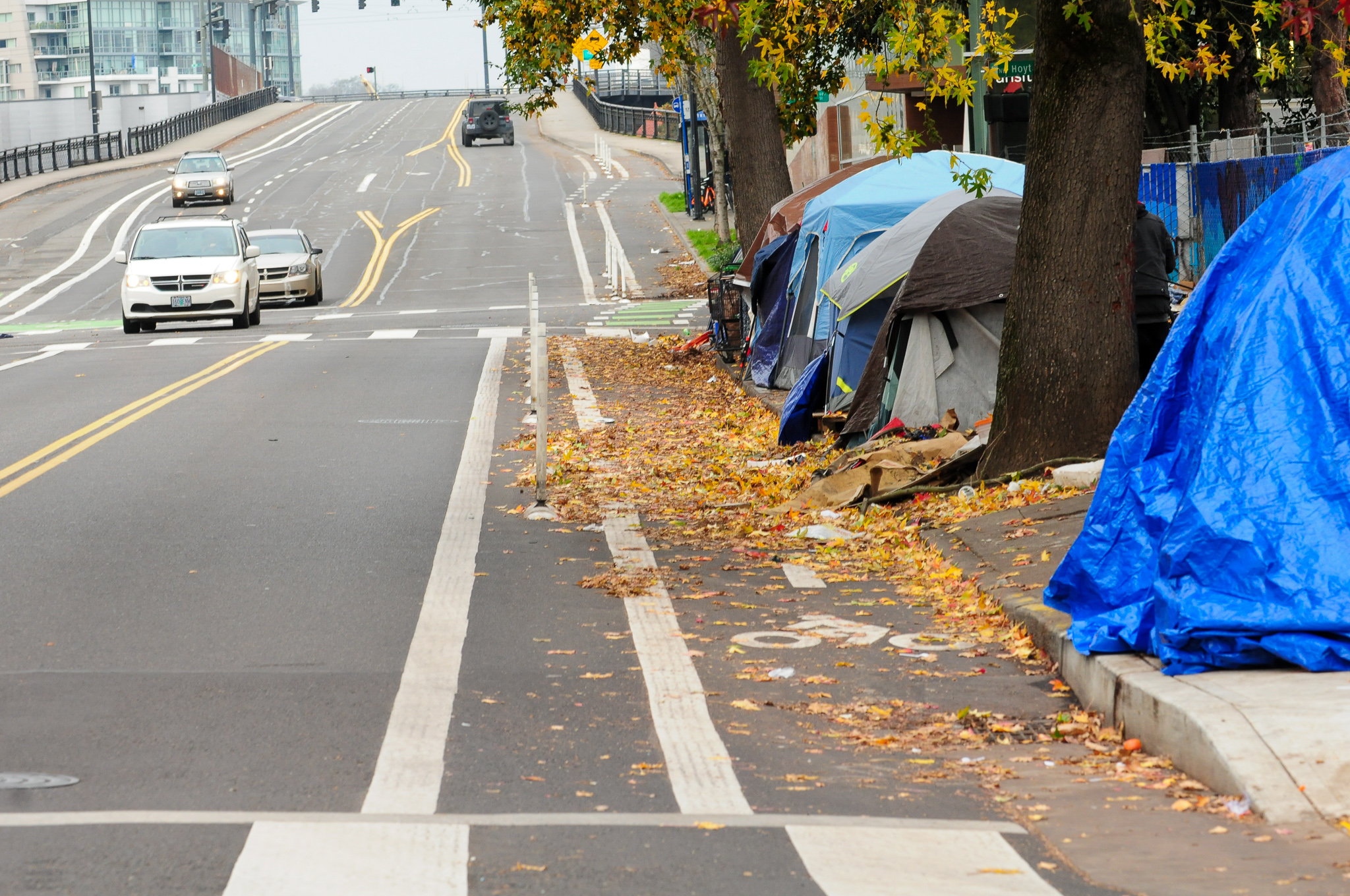
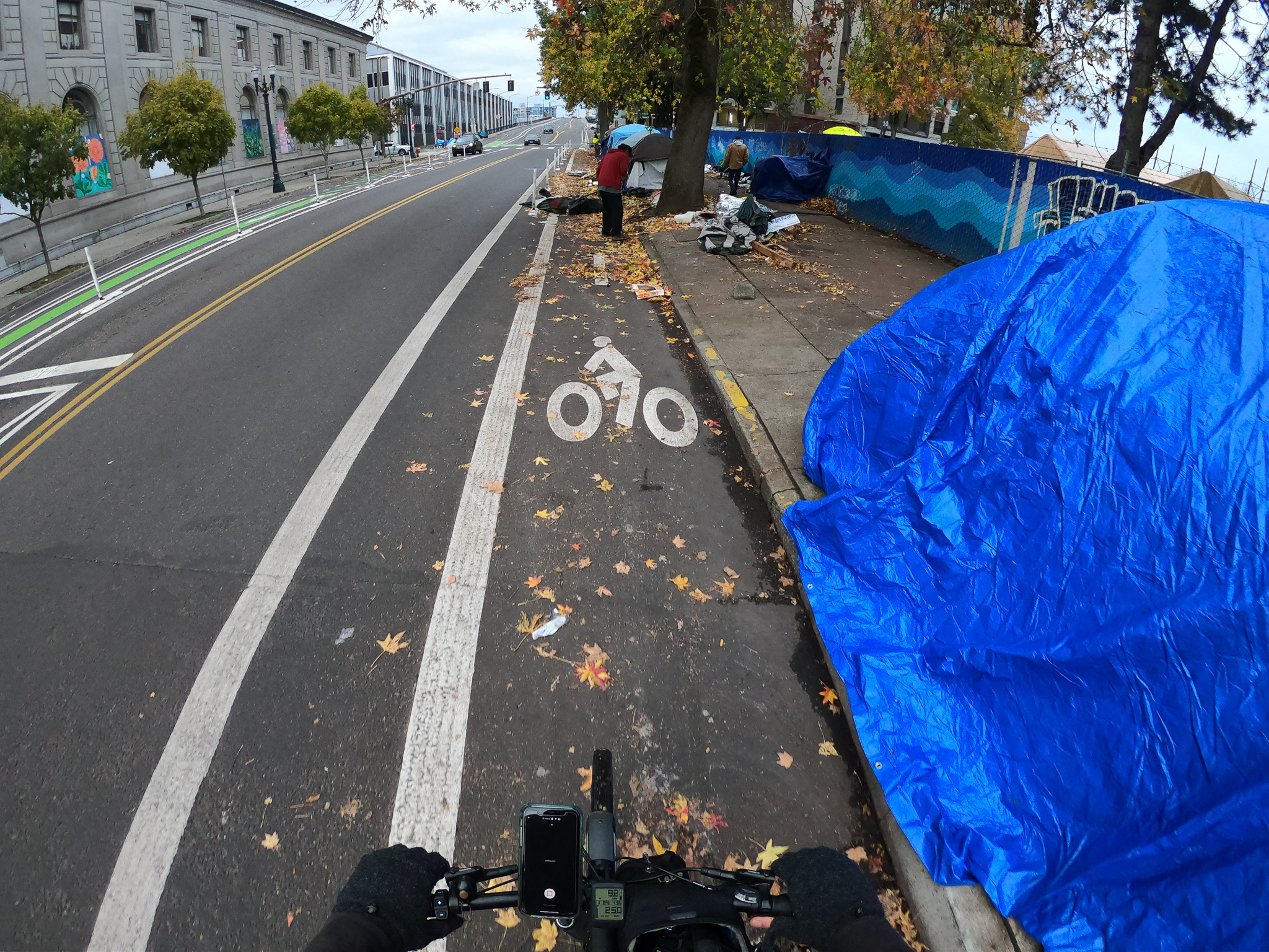
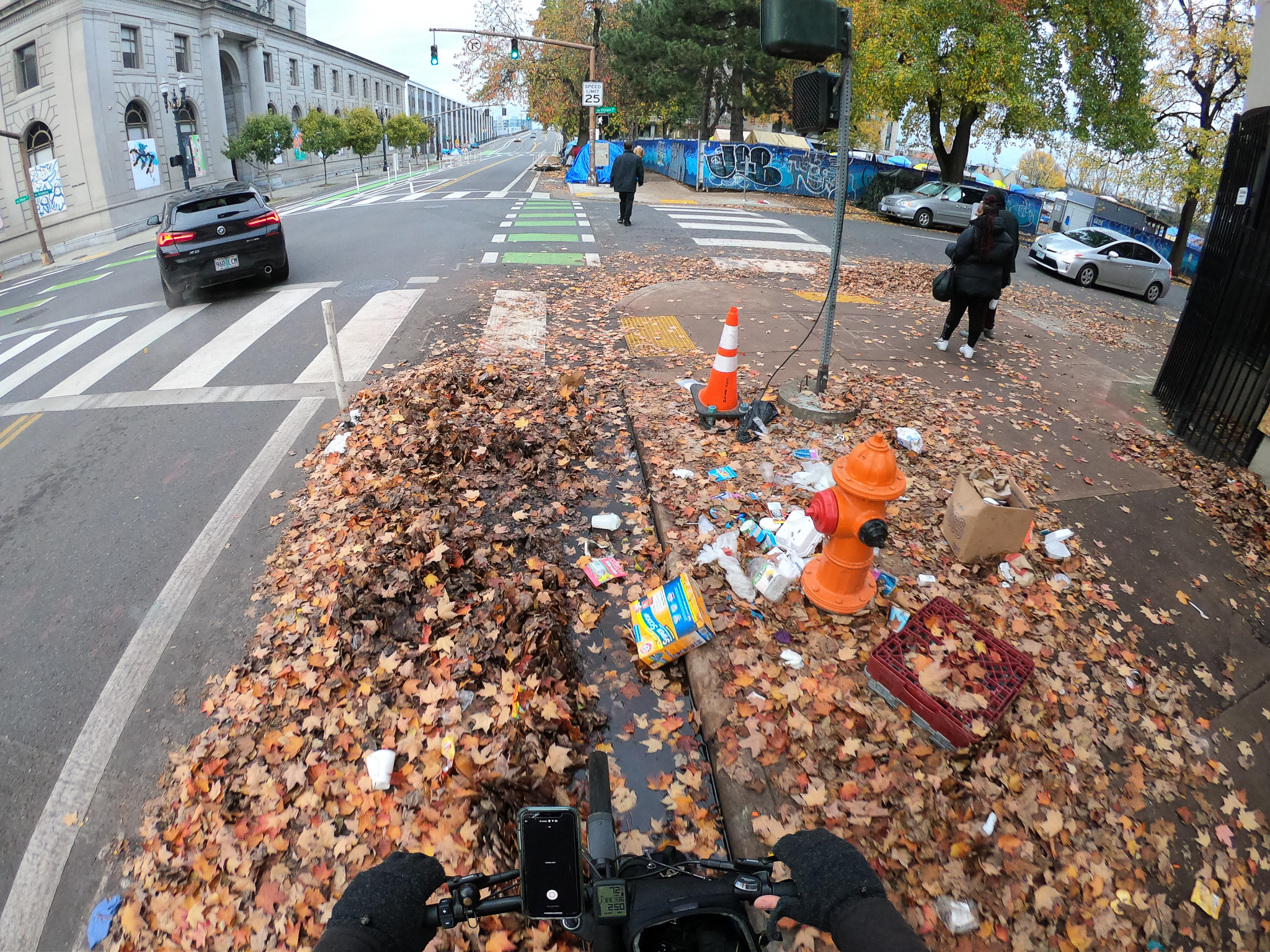
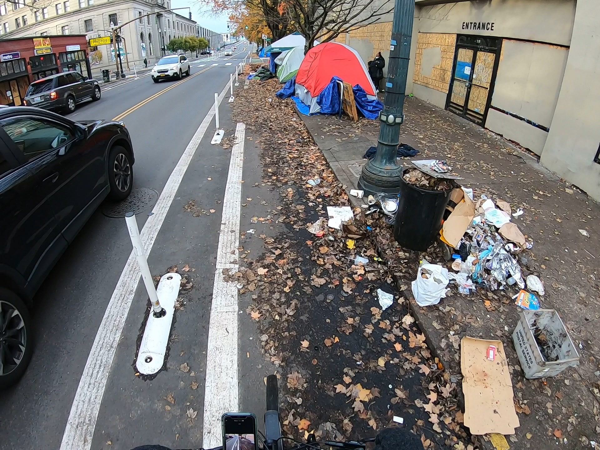
First, there’s a lot less bike traffic downtown right now because so many people are working from home and/or are choosing to drive due to the pandemic. This makes it hard to really assess how the new design is working. The amount of leaves in the protected lanes is also a big problem. This is happening citywide and it’s not yet clear if PBOT has a plan or if they even have the right tools to get into these narrow lanes.
And last but definitely not least, people and their belongings are spilling into the bike lanes and several sections are impassable. The amount of people camping on streets in Old Town has gone up a lot during this crisis and it’s no surprise they’ve expanded into these protected spaces. This is heartbreaking on so many levels and we must do more to address this issue.
Have you ridden this yet? If so, what’s your experience been like?
If you haven’t ridden it yet, check out the video below to get a better feel for the facilities:
— Jonathan Maus: (503) 706-8804, @jonathan_maus on Twitter and jonathan@bikeportland.org
— Get our headlines delivered to your inbox.
— Support this independent community media outlet with a one-time contribution or monthly subscription.


Thanks for reading.
BikePortland has served this community with independent community journalism since 2005. We rely on subscriptions from readers like you to survive. Your financial support is vital in keeping this valuable resource alive and well.
Please subscribe today to strengthen and expand our work.
Wow, these are pretty incredible changes downtown. And PBOT built a roundabout downtown? A roundabout!? Craziness!
Redesigning SW Bway has been decades in the making. It’s always big relief to see such dangerous intersections as Hoyt finally change. It will be a lot less likely to claim any more victims. I remember when NYC DOT’s PBL standard intersection design was a “mixing zone.” This allowed high velocity turns with predictable consequences for people not surrounded by metal. PBoT’s design at Glisan is certainly a step above that. A protected intersection and even signal separation might prove safer, although may cost quite a bit more. Excited to ride a safer Bway all the way to PSU some day.
Supposedly the CCIM team at PBOT is expediting the rest of Broadway to PSU to be an upcoming project in the next year or two.
Oh, those are bike lanes. Looks like the “New Portland”. Once beautiful city COVERED IN GARBAGE. No excuse.
I mean, a global pandemic and failing capitalist system is kind of an excuse? Or are you just advocating for the removal of the people? Where would you send them?
Failing capitalist system? Frankly its faring remarkably well given the circumstances.
Agree. The system is working exactly as intended.
8 figure salaries for hospital system and insurance executives, huge gains for those with passive incomes, world leadership in 3000 sq ft houses.
Spiraling housing costs, poverty, bankruptcy, unemployment, misery and addiction below.
All while Multnomah County commissioners vacation in Hawaii while locking us little people down.
I’m usually a critic of PBOT, but I quite like the looks of this. The design is simple and intuitive, and seems to be a good use of the available roadway space.
I just wish PBOT could keep up with maintenance and keeping them clear, especially northbound approaching the bridge. Its been less than a month since they’ve been finished and they are already impassable on certain blocks.
These are nice. You do ride in paths and streets full of garbage though. Email the city. Really, Dont stop.
Very quaint. Very similar to M Street in DC implemented a few years ago, worthy of a silver rating. Now then, is this an isolated piece of infrastructure, part of a unconnected network like most cities have? Or does it directly connect to 162nd?
You’re thinking of the other Broadway (NE), I think? This is SW/NW.
Broadway doesn’t even exist in East Portland, I think peters out around 68th or so. My question is, how does this infrastructure tie into a full city network? Or is it an isolated piece like most cities have?
Oh really? https://goo.gl/maps/oHLizct6R2VTVpWBA
Yup, several minor residential street sections in Parkrose Heights, Russell, and Wilkes. Nice try.
“Doesn’t even exist in east portland.” Tell that to the families who live on NE Broadway in the 80s, 90s, 100s, 130s, 140s, and 150s Sure, it’s not contiguous, but these people are Portlanders too. Come check out east portland sometime (best playgrounds in town.)
Oh, and “nice try”
I’m sorry if I have offended you.
I lived in Hazelwood 2008-2015 and biked throughout East Portland. I even named and mapped out the 4M, HOP, and 150s and spearheaded their funding, plus a lot of other sidewalk, transit, and bike projects. I know those small sections of Broadway intimately, including the pig topiary at 143rd. My point is that Broadway as a continuous main street runs N-S from SW Portland near Pill Hill north to NW, then crosses the bridge and runs E-W into N, then NE. In Hollywood it tapers down to a local street. Around 70th it merges into Jonesmore, a very pleasant but under-rated local street (is there still some gravel on it?), then it becomes discontinuous.
This project is about 3/8 of a mile long on a north-south street, so it would be a challenge for it to connect to another north-south street that’s almost 9 miles away.
But yes, it does connect to other parts of the network. In the southbound direction it upgrades an existing bike lane that continues on either side. In the northbound direction it connects the bike lane on SW Oak to the existing bike lanes on the ramp approaching the Broadway Bridge.
In comparing the two projects we can get a snapshot on PBoT priorities: $1.9m for Broadway and $5.7m for 162nd, the 162nd project is approximately 3 times the length of Broadway, both projects have bus off set lanes or “transit protected lanes”, Bway has semi-protected lanes and 162nd has no protection (except at the bus stop), PBoT removed no parking from 162nd and the East side of Bway saw removal of all parking spots, neither project has protected intersections (or “offset crossings”), despite PBoT rebuilding signals at Glisan.
I honestly have a hard time believing this cost $1.9 million. If it had cost that much they would have needed to put it out to bid, which they didn’t (indeed, the desire to get this done by PBOT maintenance crews was specifically given as the reason for a) only using paint-and-posts and b) only a doing short stretch of Broadway).
Unlike the proposed project on 162nd, there was no paving done. Per the Portland Protected Bike Lane Design Guide a Parking Protected Bike lane w/ Delineators on a two-way roadway with 56′ curb-to-curb should come to $183,400 per mile. With a construction cost multiplier of 2 that comes to $366,800 per mile, or $137,550 for the project length of 3/8 mile. If there really $1.9 million was spent on this serious questions would need to be asked about why the project quality is so low for that kind of cost.
I was hoping someone would ask that question.
Personnel, supervision, grants administration, blah blah blah…
No, that’s already accounted for in my math; that’s what the 2x multiplier cost is for.
Take the cost of D.I.Y. through Home Depot, multiply by 2, and you get the cost of your hiring a local contractor. Double that and you get what PBOT charges. Double that again and you get what ODOT charges. Double it once more, and you get what the feds charge.
They all keep adding administrative and other personnel costs, plus in some places the cost for bribes, kickbacks, unions, $15 minimum wages, pensions, medical/dental, junkets to Amsterdam, etc.
There are plenty of ways to bike to this section from 162nd. Maybe not to your desired level of separation, but there are bike lanes and greenways the whole way. In the before covid times, I biked every day from 82nd to this very area. There are fast/direct ways to get there and also some very relaxed greenways, if you like.
Would you take your 8-year-old niece and 70-year-old aunt on those routes, all the way from SW Broadway to SE 162nd? Would they feel comfortable on those routes?
Exactly.
One thing I’m noticing with changes like this–bike lanes replacing auto lanes along curbs, or replacing parked cars, or restaurant seating replacing auto lanes or parked cars–is how much nicer the adjacent sidewalks are to walk on. More safety, more elbow room, better views, quieter, easier to cross the street…and those are all side benefits that don’t even get into the benefits for biking.
I notice it especially when I walk with my dog downtown. Maybe being with an animal makes the unnaturalness and danger of walking so close to moving vehicles more noticeable.
One of the sometimes unexpected benefits of PBLs. People in cars and pedestrians are often safer as well. Designing safe streets doesn’t just benefit people on bikes.
Sometimes for fun I get on nextdoor and tell people that.
Heh. That must be fun.
I don’t know if I can get used to a counter-flow bike lane on a one-way street. Gives me the heebee jeebies.
When I first moved to Portland in 1997, there was one on NW 24th north of Burnside, but I see from Google Maps that it has since been replaced with a 2-way street.
They have some down in Eugene and Corvallis. They seem to work pretty well, but I do share concerns about having them in a busier environment. Just don’t be shocked if you see a confused driver heading straight at you from time to time.
The image appears to depict attempts to block a street with parked cars and a bike lane. In a word Stupid.
How often do you bike the road?
That’s a combative question. No points for you.
The irony is, the photos depict a bike lane blocked by a parked car.
Can’t blame PBOT for confused Washingtonians. They’ll park wherever they please.
I guess reading is just too confusing for them.
Those plastic wands between the turn lane and the main lane on that southbound weave won’t last long. I’ll give them 2 weeks, tops.
These are great bike lines that I’ve been using a lot and love them but man, it seems like every time I get on NW Broadway after crossing the bridge there are at least two cars from between there and W Burnside. It’s irritating.
Gee, I wonder if I’ll ride NW Broadway or in Vancouver (subject of Jonathan’s prior post) next. I don’t wish homelessness on anyone, but surely there are better solutions than what we have depicted in this photos. Reasonable solutions that, like Wapato Jail, our government has been opposed to implementing. But hey we got lane stripes and wands n’ stuff.
Can we wave the wands and say some magic words to make the homelessness problem go away?
FWIW, Bybee Lakes Hope Center, at the Wapato site, will be accepting residents this winter.
The Hoyt change is great. The southbound transition between lanes approaching Glisan still seems a little vulnerable if cars are racing to make the right turn on green. An elevated bike lane/speed bump where it crosses would help slow cars down.
Sure, but I’m not sure who is going to ride them, given that downtown no longer serves as a central business district or any sort of destination at all. The pandemic plus the riots were the 1-2 punch that knocked out downtown Portland, rendering it economically and culturally irrelevant. I don’t foresee it coming back within the next decade or so. Remote work – at least part time – will persist even after the pandemic is over, and countless businesses will have already gone under or terminated their leases. There won’t be a strong incentive to reopen in a place as dysfunctional as downtown Portland.
There are thousands of humans who *gasp* live downtown. While I’m sure you are a top economics and policy expert, I’m not sure you are correct on this one.
Even with telework there will still be demand for office space and there is still huge demand for housing. If the commercial real estate market never fully recovers, a lot of the office buildings could be converted into housing like the factory lofts of old.
If you Google “portland downtown apartment vacancy rate” and click the first link, you’ll see the it’s currently 9.8%. If you’re proposing that downtown be converted to a new Pearl District, the demand isn’t there right now. People want space. It’s all about space right now.
Please cite your source. Thanks.
Portland Apartment Investor, November 2020 edition, page 15.
https://issuu.com/hfore/docs/2020_newsletter_final?fr=sNWM2MDY0MTU
This shouldn’t surprise anybody. I’m only surprised it’s not higher.
Space, it’s so hot right now!
…the final frontier…
A few people have commented about the lack of maintenance and upkeep once these bike lanes are built. I agree that it is disappointing and there doesn’t seem to be much in the way of meaningful conversation to get the City to put proper focus on it. While it’s great to have more dedicated space for bikes, always having to navigate debris and litter in the bike lanes is challenging and acts as a significant deterrent towards goals of getting more people on bikes.
When thinking about possible solutions, one thought I had is to set up a program similar to the adopt-a-highway program where local businesses and individuals can be engaged to take more ownership of the bikeways. Sponsorship money could be raised and a proper maintenance plan put in place to address the maintenance deficiencies. Thoughts?
All I can see is, bad motorist behaviors. Car parked backwards on wrong side of street (approaching NW Flanders; should be a ticket. Car blowing the stop sign and nearly blowing the crosswalk (NW Davis). A proper stop is when the front bumper lines up with a) the white line on the road indicating the stop line or b) the implied white line – on the same line as the stop sign. Car at rest in the crosswalk (NW Couch).
Yes, but cars are vital to our economy. 😉
Also, a car parked in the bike lane.
Maybe it was a freight delivery vehicle cunningly disguised as a car?
I don’t think you were serious, but I’ve seen a lot of (Amazon?) delivery drivers this year driving around neighborhoods delivering packages in what are obviously their ordinary personal vehicle. Plus food delivery is usually a personal vehicle. A lot of unmarked stalker-vans doing deliveries. Mumble Mumble “gig economy” … I guess uniforms and logos are soo 2010 now?
Actually, I was serious, for the very reasons you have succinctly stated. People need to earn income, pandemic or no pandemic, and the stay-at-home orders are making life literally impossible for the poorest residents in any city.
Even freight / delivery drivers need to abide by the “no parking” laws. There is a sign right next to the car.
“Need to abide” and actually abiding are very different things. Judging by their behavior, many delivery companies have decided the risk of a ticket is less than the benefit of parking wherever to make a speedy delivery. I also recall that the City has negotiated “bulk rates” with companies like UPS that accrue lots of tickets, which amount to a license fee to violate parking rules.
And the overall costs for tickets just becomes part of the costs for making deliveries, like paying for gas or repairs. Ultimately it’s the consumer of packages who pays through increased rates, not the delivery company.
The infrastructure is partially to blame. Loading zones used to be a thing needed by inventoried businesses a few times a week, not apartment complexes. With the rise of Prime and similar, I bet there’s 20x more delivery traffic today than there was 20 years ago. And no corresponding increase in infrastructure to support those deliveries. So deliverers do the only thing they can do; violate regulations and carry on. Then as HK says, the lawyers sort it out afterward.
Well, I guess I’ll be skating in the traffic lane every fall.
Thanks for this article – very nice overview. However, the word “protection” rankles – as in “where bicycle riders don’t have protection.” Those plastic wands don’t actually provide protection – a car or truck can leave its lane and hit you on your bike with nary a pause. The wands provide more of an illusion of protection, or perhaps protection in the sense that a driver might look up from her cell phone when she hears the wands slapping the underside of her SUV, which might cause her to apply the brakes and not hit you on your bike. But that’s about all the protection they provide. I wonder if we might come up with a better term – perhaps “delineated” lane? Or “marked by wand” (MBW) lane??
I like wand protected bike lane. It lends itself to something incredulous. Yes PBoT could have done a lot better, using protected intersection design, for example. But I think we should give them credit for removing parking, which–and I may be in error–is something unprecedented for them. Right now nearly all safe designs are precluded by PBoT’s often religious adherence to maintaining car capacity, speed and parking. Perhaps delivery vehicles drop off zones might have some public benefit, but parking is not (as argued, for example, by PBoT during the Hawthorne Pave and Paint project) in fact a public good. So we really need to give credit where it is due.
I’m sure it works fine. I used to ride Broadway every day but changed jobs a month ago and haven’t seen the new configuration. In all honesty, stuff like this is exactly why I’ve given up hope that cycling will go anywhere.
Broadway is a very slow street to the extent that you can actually overrun lights pedaling uphill. While I’ve witnessed plenty of conflicts (overwhelmingly cyclists hooked when passing from behind of vehicles that were obviously about to turn), I never personally experienced any in 8 years.
In the time I’ve lived in Portland, I’ve seen a number of infrastructure changes, overwhelmingly to serve short hops on easier streets. Even in these places, the messaging has consistently been that riding is dangerous/terrifying, normal road/weather conditions are a hardship, and that cyclists don’t belong on roads that go where people actually need.
Add in that the messaging comes from a group that is more physically capable and has to go less distance than the general population, and you gotta wonder why anyone would start riding — and based on the cycling numbers, they don’t.
It’s not that they aren’t riding, it’s that people who are riding are stopping. With the congestion and hostile motorist, Portland is becoming “everytown, USA” when it comes to biking. PBOT should be able to eliminate most cyclist commuters within ten years if they just stay on track.
Portlanders should ask why a “progressive” city that acts so upset about climate change can’t manage to build evidence-based biking infrastructure or even limit greenways to green modes of transit. Portland could have a world class bike network for less than $10 million if they spent it on diverters to be put on greenways. But we wont, because we are at the end of the day a city that caters to SOV motorists and the freight industry above everything else.
What is “evidence-based biking infrastructure”?
How do you figure that the people who are riding are stopping due to infrastructure problems? It keeps getting better, yet the number of cyclists doesn’t go up.
Even in showcase infrastructure areas such as the much ballyhooed BN, it’s empty except when the weather is perfect. Even in non COVID times, there’s nothing unusual about riding miles at night without seeing a single cyclist. Even in the day, I hardly see any once I get a few miles out.
I think it is clear is that quite a few people will ride short distances in perfect weather at key times, if they don’t have to work hard, transport much stuff/people/animals and they feel safe.
Given what people here find as a disincentive to ride, it shouldn’t be surprising that people who aren’t cyclists don’t want to start riding further under more difficult conditions
Modal share is directly connected to protected infrastructure. Portland is one of the few cities that has refrained from building protected infrastructure. Portland has around 5 miles of on street protected infrastructure. Almost none of the recommended protected bike network proposed in the 2030 plan has been built. Accordingly our modal share had dropped to around 5% in 2019. NYC, for example, has built 20-30 miles of PBLs per year, predictably increasing its modal share growth by twice the amount (see pg 11) as other US cities. When you build a practical, safe space for families, people start using bikes. If Portland built a network of PBLs the same would happen.
Weird that the few areas that get quite crowded with bikes are empty when it’s dark, cold, wet etc.
If only people had further to ride and maybe add some hills, I’m sure it would be full of bikes.
As for deploying PBL everywhere, I think it’s more likely to make riding super scary. I refuse to ride some of it, especially at night. I feel safer on the roads with the drunks.
I hold out little hope for modal share. It’s so hopelessly slow except along a couple specific routes that it’s unusable. You could literally live at a MAX stop and it would take you longer to get to the airport than it did for me when I lived 73 miles away in Monmouth. Even when you have miles to go, it’s often faster to be on foot than to take transit.
Until transpo advocates’ vision of success is about solving actual transportation problems rather than the mere act of getting people to use any form of transportation other than a car whether or not they need to go anywhere, I see no reason to expect progress
Reported modal share rates are directly proportional to the rate in which local residents of all social classes and education are both surveyed and actually respond to those surveys. The standard is the American Community Survey that the census does annually. If you look at the standard errors year-by-year from say 1990 to 2015, you’ll see a steady increase in the error rate and a steady decline in the percentage of respondents to the survey – basically fewer people are actually responding to the survey, and of those who are responding are becoming less representative of the population as a whole. In 1990 the numbers for bike usage were pretty reliable, but they are no longer really reliable today in most of the USA. The 5% rate you list is actually 5.34% and it is based on people age 16 or over who commute to work; it doesn’t include people going to school, doing errands, riding recreationally, etc. Based on the errors, Portland’s bike usage could be as low as 4.65% or as high as 6.02%, but our certainty of what the actual rate is, is becoming less certain every year.
Very interesting. Would appreciate links. I know people for bikes does not calculate its mode share strictly from the census data, perhaps for this reason. Here is their ridership methodology. Here is a link to their ratings spreadsheet where Portland currently sits 12th in the US. TBH I’m not entirely sure how they calculate everything.
I used the numbers from https://data.census.gov/cedsci/table?t=Commuting&g=1600000US4159000&y=2018&tid=ACSDT1Y2018.B08301&hidePreview=true and used the error range to calculate the low and high on a common spreadsheet. Thank you for the links. I note that PFB uses a lot of complicated statistical estimating, including using self-reported data, mixed with ACS data. This is a very complicated mix that really needs to be broken down into its components and have regressions run on each component to find potential bias in order to be replicatable for peer-review analysis, otherwise its simply a “black box” similar to what DOTs do for traffic modelling. They also point out that ACS data is an estimate, not a count, based on a sample.
They also have a useful basic caveat:
Traditional approaches to analyzing these estimates penalize cities that have high rates of public transit, walking, and working from home because when those measures are high, bike-to-work mode share is, by definition, lower. At the city level, the additional challenge is that it is difficult for cities with large land areas to achieve the bike-to-work mode share that is possible for cities with small land areas because jurisdiction boundaries often arbitrarily include or cut off outlying areas with a low bike-to-work mode share. Additionally, some jurisdiction boundaries have been geographically fixed for decades while other communities are actively annexing these low mode share areas.
Portland more or less stopped annexing land in 1991 and has since covered an area of 145 square miles (not including the Bull Run watershed). Most of the city is urban or suburban, but some of it is still rural (parts of East Portland and North Portland) or forest (Forest Park, Powell Butte, etc.) The high mode share of inner Portland is offset by the rapidly growing population in East Portland (now over 30% of the city), as well as high rates of work-from-home and transit use. Portland, as a large city, will never have the use rates of a Boulder or Davis, which are much smaller communities, nor will it ever be as dense as Manhattan or Amsterdam. But I agree, there’s always room for improvement.
Our bike infrastructure isn’t getting better. That’s the problem. PBOT keeps building low value bike lanes that most people don’t feel safe in. PBOT is just building more infrastructure for the type of people who would just ride in traffic regardless. This project is a great example. It will help have the plastic wands and it helps making Hoyt no right turn, but this infrastructure isn’t going to feel any safer for someone who is interested in cycling but afraid. This project wont create any new cyclist.
I don’t know what you mean by BN but there are zero areas in Portland that have good enough bike infrastructure for your everyday person to feel safe.
My idea to improve the conditions of riding. Of course if PBOT really wanted to move away from cars, they need to work with TriMet to improve our terrible transit system
I think that statement is unlikely to be true. I would assert that most greenways (or similar routes) are pretty good, and feel pretty safe to most people, and that conditions are much better now than they were in the past. “Everyday people” prefer driving because it’s less effort and more comfortable.
You claim that our bike infrastructure is not getting better, but it is MUCH better than it was in the 1990s when I, very much “everyday people”, adopted my trike as my primary means of transport, and SE 26th south of Division was a state-of-the-art facility and the sidewalks on the Hawthorne Bridge were half as wide as they are today. Ridership is falling now that we have even more infrastructure, so if infrastructure were the prime driver of cycling rates in Portland, you’d have to say that what we’re building is deterring riders; even if you discount the quality of what’s being built, surely it’s not worse than nothing.
Rather, riding in Portland has always had an element of fashion, and, right now, riding is simply less stylish among the new arrivals than it was in the past. But I also believe that, like all things fashionable, rates of riding will cycle back up.
Meanwhile, I, permanently unfashionable, will keep on biking, and will keep encouraging PBOT to continue improving the infrastructure.
From my years of work promoting transportation options for the commute to Swan Island, I’d say (guess?) that all things being equal, the price of gas is the biggest variable for influencing folks’ commute choices. Its been on the low side for half a dozen years now…about the same time span of stagnant bike mode split. But that was all before the “plague” and a ton of working from home and fewer cars on the road in the peaks. But I have sure seen a bike boom on our local Greenways in Inner NE…lots of families out for exercise and fresh air.