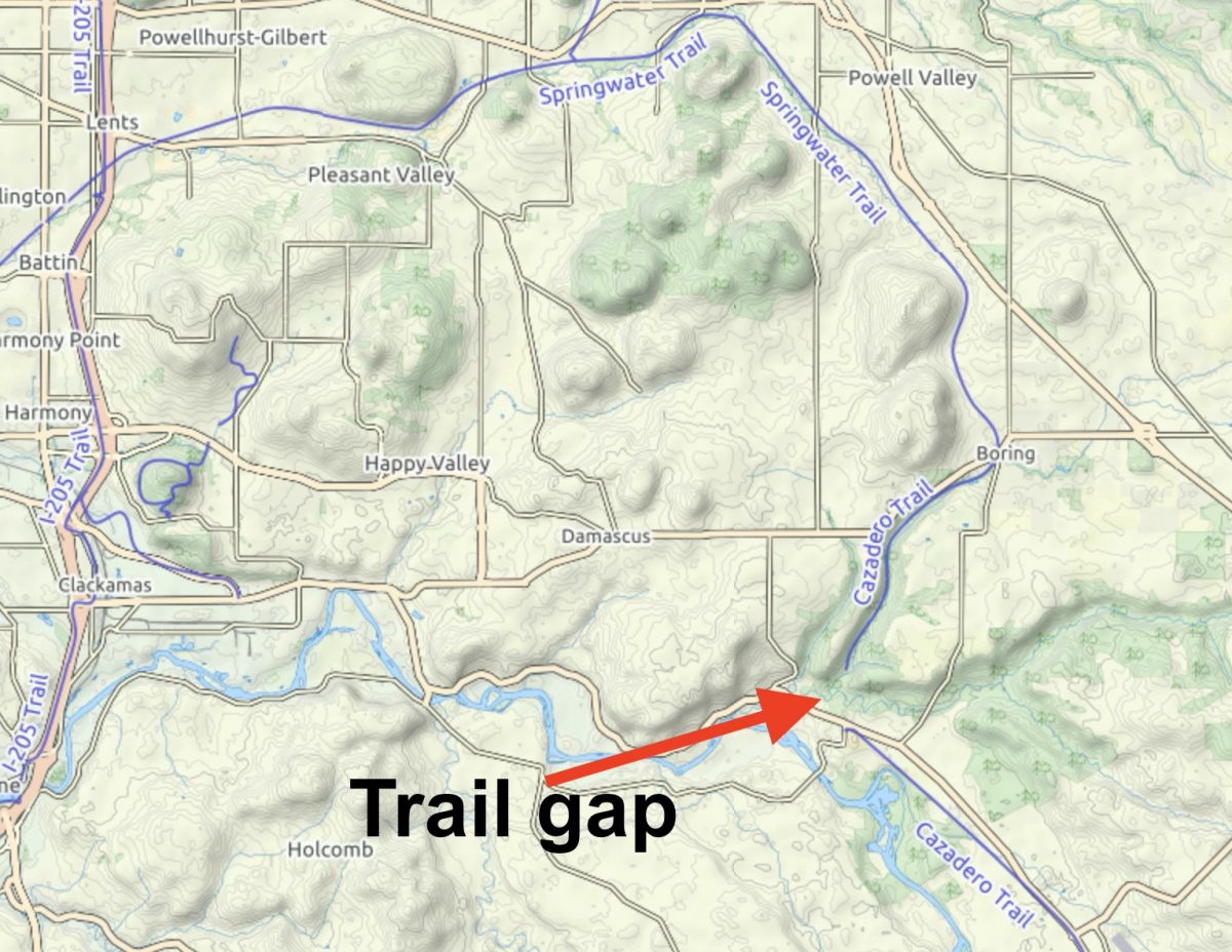
About 2,000 feet through a riparian forest are all that separate us from having a carfree connection between Portland, the Clackamas river, and beyond.
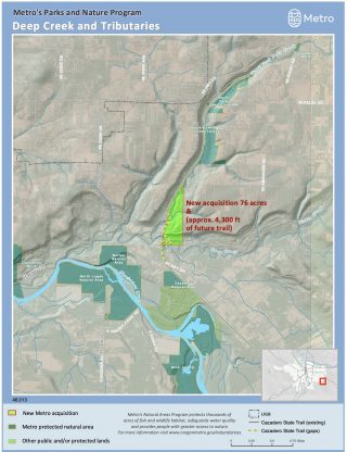
Metro just finalized the purchase of a 76-acre parcel that will close that gap. Once completed, this project will have massive impacts to bicycle riders of all persuasions.
First, some background:
The abandoned railroad line between Portland and Estacada that the City of Portland first acquired and paved in the 1990s. In 2013 pavement was extended into the small of Boring, about 20 miles from where it starts just south of OMSI. South of Boring is an dirt trail section that heads toward the Clackamas River and is known as the Cazadero Trail. Unfortunately, the trail ends just north of Highway 224. Just south of the highway, at Barton Park, the trail picks up again and follows the old railroad bed another four miles before ending in Eagle Creek (north of Estacada).
That small trail gap was created when two wooden railroad trestles over Deep Creek and North Fork Deep Creek burned down after the line was abandoned in the 1930s. For the past decade or so, state and regional agencies have applied for federal grants to construct new bridges over the creeks. The last attempt in 2013 sought $4 million for the bridges but the project was not selected for funding.

Advertisement

Now Metro’s Park and Nature division has stepped up with an $850,000 purchase of land that clears the way for Oregon State Parks to design and build a new connector trail. The 76 acres is adjacent to Camp Kuratli and was previously owned by the Salvation Army. In 2013, Metro estimated the bridge project would serve over 327,000 annual biking and walking trips and would have an economic benefit of over $6.4 million in the first five years post-construction.
The additional land gives Metro a total of 165 acres in the area. It also gives Oregon State Parks, the agency that will ultimately design and build the project, more space to look at a solution that doesn’t require “cost-prohibitive” bridges. Instead, they’ll build a series of switchbacks to cross the canyons. Metro estimates the project will build about 2,900 linear feet of new trail.
This project is important not only because it will close a trail gap, but because current alternate routes like Richey Road, Kelso Road, and Amissiger Road between the end of the Springwater in Boring and popular destinations like Barton County Park and Milo McIver State Park are very stressful. “All of these roads have no shoulder, poor sight lines, fast moving traffic, and
sections with steep grades,” wrote Portland resident and former Cycle Wild ride leader Shawn Granton in a letter supporting the 2013 grant application. “This four-mile section of roads is the most dangerous and treacherous part of our trips out into the Clackamas River region. It can be a harrowing experience for both seasoned and new bicycle campers alike.”
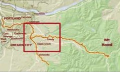
This purchase by Metro provides much-needed urgency for the ultimate dream: An off-street path from Portland to Estacada and then along the Clackamas River and into the Mt. Hood National Forest. Stay tuned for opportunities to weigh in on this project. Metro cautions that, while they hope a trail is built, nothing has been finalized and it could be years before the gap is closed. That just means we need to create as much pressure on these agencies as we can to get it done.
While we wait to hear from Metro and Oregon State Parks about next steps, check the Ride With GPS map below from regional route-master Ryan Francesconi to get inspired about the future:
— Jonathan Maus: (503) 706-8804, @jonathan_maus on Twitter and jonathan@bikeportland.org
— Get our headlines delivered to your inbox.
— Support this independent community media outlet with a one-time contribution or monthly subscription.


Thanks for reading.
BikePortland has served this community with independent community journalism since 2005. We rely on subscriptions from readers like you to survive. Your financial support is vital in keeping this valuable resource alive and well.
Please subscribe today to strengthen and expand our work.
Thanks Metro’s Park and Nature division! [This may be one paved trail I have not yet ridden. I will have to investigate.]
Aaaaaah! I’ve been waiting for this since I was 10 years old! Thank you Jesus Christ Superstar.
This is incredible news! That gap needs to get bridged ASAP…Amissiger is a death zone.
It seems like a good project, but the prediction of 327,000 annual biking and walking trips is beyond belief. 900 trips per day sounds like the volume on the Springwater Corridor near Powell Butte on a nice summer weekend. I used to commute on the Springwater Corridor to Gresham and during winter months I was often alone.
Plenty of camping opportunities along the trail, though. That would greatly increase daily trips.
I have mixed feelings about stuff like this. Induced demand works for cycling too — and often manifests itself in a greater increase in driving than cycling.
While it looks great from an immediate riding perspective, the practical effect will be to get a bunch more people driving to pedal a few miles. A significant chunk of that traffic would be on otherwise quieter and more rideable roads discouraging cycling except recreationally. If it’s anywhere near as successful as predicted, a nice quiet place could become cycling’s answer of Multnomah Falls.
What evidence do you have to support this?
What basis do you have for believing that the vast majority of people who cycle this will pedal from Portland to enjoy this?
Anyone willing to pedal that far to that location isn’t going to be dissuaded by this stretch that’s going to be linked up for the simple reason that it’s not going to be a big deal compared to what they’re used to.
“Active” recreation means driving for most people. If you don’t ride the west hills, I recommend doing it any weekend. Practically all of the traffic on the roads — which seems heavier then than on working days during rush hour — is recreational traffic to trailheads and whatnot. Every trailhead will be clogged with cars, many hauling bikes.
People even drive to get to local cycling events that are much closer as well as paths. Don’t kid yourself. If there’s a huge boost in cyclists there, most will be driving.
I doubt this crossing will significantly impact the area in the way you describe. When the Deep Creek gap is closed this will result in a ~14 mile out-and-back gravel ride with a busy highway crossing in the middle (there’s still a significant gap between Eagle Creek and Estacada to overcome). I don’t see many folks loading up their family’s bikes and driving to reach it; it just doesn’t have the “wow” factor of, say, Mosier Twin Tunnels or even Leif Erickson.
Furthermore, the only thing this adds are switchbacks and a trailhead at the bottom of the hill. Not really much of a change in and of itself– If you want to drive out to Boring to ride those 14 miles, you can do so today.
If you are correct, why build it. Serious question, I have not been there.
Metro is not going to have any money in the new post pandemic times, there must be a thousand places they could spend money better.
I wouldn’t describe the impact that way — I was just going off the projections others provided. Given that hardly anyone rides showcase infrastructure near the core when there’s a bit of weather, darkness, or cold, my own expectations are more tempered.
Not sure what the point of driving to ride 14 miles would be. That’s not even much of a commute.
I find the denial that people drive to ride amusing. I’ve never lived anywhere else where where driving to ride was so common or where so many cyclists thought they needed separate infrastructure (another way of saying they don’t belong on the roads)
Destination cycling is a thing here, and a lot of people drive to get there. If you don’t believe that, just tell yourself that people will cycle to Timberline later this year to enjoy the facilities there and then go on about how selfish people are for driving half that distance in their cars during the week to get to work.
There are a couple very disparate perspectives you might be alluding to: People on bikes “need separate infrastructure because they don’t belong on the roads” or people on bikes, just like people just walking about, can get smashed by big metal blocks very easily if they don’t have physically separate space. This perspective is central to why Portland hasn’t had a significant change in mode share for decades, while Montreal, Vancouver and New York all have.
I’ve driven pretty far for rides shorter than that, it’s amazing what you’ll do when you want to experience something new with your kids.
I’m afraid you don’t really understand what this connection is actually for.
Agreed. The only way we will see big increases on this section is if they pave it between Boring and Barton after they add the creek crossing.
Touring bikes, commuter bikes, cross bikes, mountain bikes of any sort, and of course gravel bikes can handle the surface on unpaved rail trails. It’s pleasent to ride and reasonably fast. I would for sure ride this trail as an option to getting strafed by fast.moving MV operators on narrow blacktop roads.
How about the fact that the number of people biking on Portland streets quadrupled from 1995 to 2010?
Keep in mind this is the ONLY physically separated path out of Portland. If families go on bike rides, this is the only one to do it. If families go camping with bikes, this is the only choice. If you commute from East Portland, this is the only safe option.
Imagine having a Hood to Coast for people on bikes Salmonberry plus the Cazadero. Whenever we see streets closed to cars or physically separated bike lanes put in, ridership soars. We just rarely see it in Portland because the infrastructure is so poor.
If physical separation is necessary and there’s only one usable path, I’m not sure what the purpose of projects like this would be.
How do you get to the path, and do you really think the total distance is appropriate for families camping with bikes to ride from town?
If we want more people cycling, it might help if those already doing it helped others see how easy/fun it is. Not too many people will want to start if experienced people think it’s scary/dangerous or requires nonexistent facilities. Nor should they — cycling is pointless if you can’t go where you need. Luckily, the road network goes does a pretty good job of covering the town.
You should ride someplace other than Portland. The infrastructure is not only very good, but it’s much better with easier traffic than you’ll see in the rest of the state. That’s why people enjoy fairly excellent riding all over.
This ridership soaring thing just isn’t true except in a few select spots when the weather is good.
It’s the old song, ‘Bike Lane Ends’. There’s a facility of some sort, better or worse, and then at the rough patch it goes away. Guess that’s the part where Jesus has us on his back.
Great reporting. Thanks for covering this Jonathan!
The one downside I could see by not building bridges would be the use of switchbacks like the ones used on the Vernonia trail… These are very silly and not designed for cycling. I wouldn’t use it.
It’s the switchbacks or several multimillion dollar bridges to replace the ones burned down when the trolly was running.
One upside: saving millions of dollars and getting this trail gap closed years earlier.
What kind of bike are you using? I’ve been able to navigate those switchbacks on several bikes, including a longtail cargo bike with 2 kids on the back.
I’ve been dreaming of closing that gap for years. I’ve only ridin Amissiger a few times, but it’s extremely stressful. Estacada is a gateway jewel of a town to the Mt. Hood region. Yes, bridges would be better, but low stress switchbacks is 100% better than Amissiger.
Bravo Metro and all those who supported the purchase.
This is fantastic news!
Is there a way to get across Deep Creek today? I tried bridging this gap several times myself last year without success as I ended up deep in the weeds in the first yellow section of the Ride w GPS map.
No. I asked around before doing this story and heard it’s not possible to get across the creek on foot as it stands today.
Gaia’s already updated and has a trail to the creek. If you’re willing to get your feet wet, there’s almost always a way. I’m going to look for one.
I was just out this way with a friend before all this virus madness. It’s a fairly steep dive at the end of the trail. If you were on foot, not carrying a bike, yeah maybe I suppose. But with a bike on your shoulder, no, I absolutely would not try it.
How exciting! I really hope the whole trail can be paved so that everyone can use it!
I took my older child camping at Barton Park, via cargo bike, a few years ago. I wouldn’t do it again without this trail gap closed, specifically because of the uphill climb on Amisigger. Even leaving the campground before 10am on a Sunday morning, traffic was heavy enough to make it unpleasant and a bit dicey.
By the way, to the point someone made about the highway crossing at Barton Park, that’s next to nothing if you’ve already managed the ride out there. It’s not even 1/100 of the danger or problem that Amisigger Road itself is.
With the trail fixed, you’ll have a phenomenal, low-stress ride all the way from the core of the metro area to a campground. We don’t have that now, nor do many other metro areas. I have also biked to Stub Stewart and Champoeg for camping, but both of those involve several miles of riding on moderately busy roads. This is a game-changer.
Search ‘Oregon Bicycle Industry Dollars’. A 2014 survey showed that bicycle businesses have a $400,000,000+ annual gross with some segments of the market reporting excellent growth potential. Yes, stuff has happened since then. Some people are having to look at their business model but also, suddenly, it’s hard to find a bike for sale under $1000 anyway in the US. That’s a boom.
Amissiger Road has a been a stumbling block for bike travel SE from Portland for years. It limits who feels safe travelling by bike, when they travel, and in what numbers. The point is not to create a destination place to ride, but rather to open up a county, a watershed, or a major part of the state to bike travel.
I would welcome an off-road option using switchbacks on a trail but I think it is short sighted not to budget 4, or even 6 million dollars for bridges. Put money into an industry that is going to keep growing! Add connectivity to a network of bike routes that will let people travel without burning fossil fuels, and place value on the time of people who choose to travel in that way.
Yes, ODOT’s budget should require safe bike infrastructure along almost all highways. Instead they build highways and add a bike lane as an afterthought. Right now switchbacks can get this open. But in the future, bridges and this sort of connectivity should be required before any adjacent highways are repaved or widened.
I’ve been riding out to Estacada a few times a year, and each and every single fucking time I get buzzed by asshole trucks that don’t want to yield on the up or downhill of Amisigger road. I can’t believe there haven’t been any cycling deaths on that road yet.
Any time my friends discuss going out to Estacada and beyond, that gap is the element that either keeps us from going or forces us to take a motor vehicle.
Even if the gap were stairs , it would be better than having to stick to the traffic.
Even if the gap were closed by a dirt path and a rope bridge, I would take it rather than deal with traffic.
How can we help get this path built ASAP?
That exactly !
Honestly I don’t like saying this but this is the #1 thing I miss about living in Belgium where I grew up. Just a way to go out in the country without always ending up at one point in the middle of what feels like racecar tracks.
I don’t ALWAYS need some fancy infrastructure or anything, just a dirt path is fine at times even if you have to walk your bike. But in so many places here you’ve got this multi-million dollar infrastructure which is great but then it comes with these missing connections were you can almost see the other side but it’s a no go so now you have to go out of your way on some dangerous road.
In fact I used to own property in that area around Springwater Rd, and it’s amazing how many dead ends there are that would be great for walking accross but again you’ve got 100 feet missing here and there with a bunch of no tresspassing this and that. So then you have to DRIVE to the park even when you live in the middle of farm land! Arrgh! I suppose in Europe we have the benefit of centuries of people just walking around before cars were a thing so we have hundreds of miles of unimproved pathways that became rights-of-ways even accross private property. They are not always fancy but they get you from point A to point B without having to find yourself in the middle of some nasty freeway. So yeah we don’t need a multimillion dollars bridge that’s never going to be funded, just a legal passable way accros that canyon will do just fine.
Tomas would know!
Enough anecdotes start to look a lot like data.
Let’s brook no delays in getting a path and a bridge built.
I live in Damascus and this is very promising news. I ride extensively in the area, but I never ascend Amsigger or 232nd drive, way too sketchy. Tickle Creek road out of Boring is nice, but it dumps you out on a dangerous part of Hwy 211. There simply is no safe route to the Clackamas river from the end of the Springwater in Boring. True to its name, Deep Creek has steep gorge walls at the site in question, and not passable on foot, let alone with a bike on your shoulder. The condition of the Cazadero from Boring to Deep Creek is good, but the section from Barton to Eagle Creek is pretty bad. Loose gravel, overgrown with blackberries, and chopped up by private property. It’s easier at this point to ride on Hwy 224, which has an ample shoulder all the way to Estacada. I’m sure hundreds of bikepackers would utilize this route, as it opens up hundreds of miles of gravel and camping in the Clackamas river area of Mount Hood, and nothing beats getting there by bike from your front door.
I’m curious what the status of this project is….any updates?
Hi Maria,
The project has been delayed because of Covid-related cutbacks at OR Parks and Rec Department. I have emailed with them recently about the demand for a connection that maybe isn’t a nice bridge and paved path, but that at least would be a hike/hike-a-bike trail over the creek to the other side. This is something many folks on the Unpaved/OMTM list have talked about. OPRD is aware of this and says they will be working/considering an interim trail option until the fully paved path can be built. Stay tuned.
Thanks for the quick reply. I just knew you’d be on top of it. I’d be totally down for hike a bike over Amsigger any day. Thanks for all you do!
Just curious…. Is there a interim trail or one in the works? I can’t find anything recent in this trail
I wish this project would move forward. I have loved riding out to Estacada and The Roaring River Wilderness. Connection to the Clackamas river valley and bike paths all prove pretty dangerous currently. I’ve had too many close calls on Amisigger to even consider touching it anymore. 224 all the way to Carver is the only “safe” route in my mind.