
(Photos © J. Maus/BikePortland)
Tillamook is a vital east-west link in Portland’s biking network. Established as a cycling-priority street over 20 years ago, it was one of our original “bicycle boulevards” (now known as neighborhood greenways) and it provides a lower stress alternative to Broadway between the Hollywood neighborhood and I-5.
Like many of our bikeway streets, in recent years Tillamook has fallen victim to the scourge of driving abuse. In their 2015 Neighborhood Greenways Assessment Report (PDF), the Portland Bureau of Transportation acknowledged that Tillamook lacked the traffic-calming features and safe crossings of a modern neighborhood greenway. Tillamook was recommended for interventions to bring down driving speeds and reduce the number of drivers overall.
Several recent updates have recently been completed. There are now green bike boxes and bike light indicators at the crossing of Martin Luther King Junior, fewer stop signs (not that those matter as much for bicycle users as of January 1st!), and speed bumps have been added throughout the corridor.
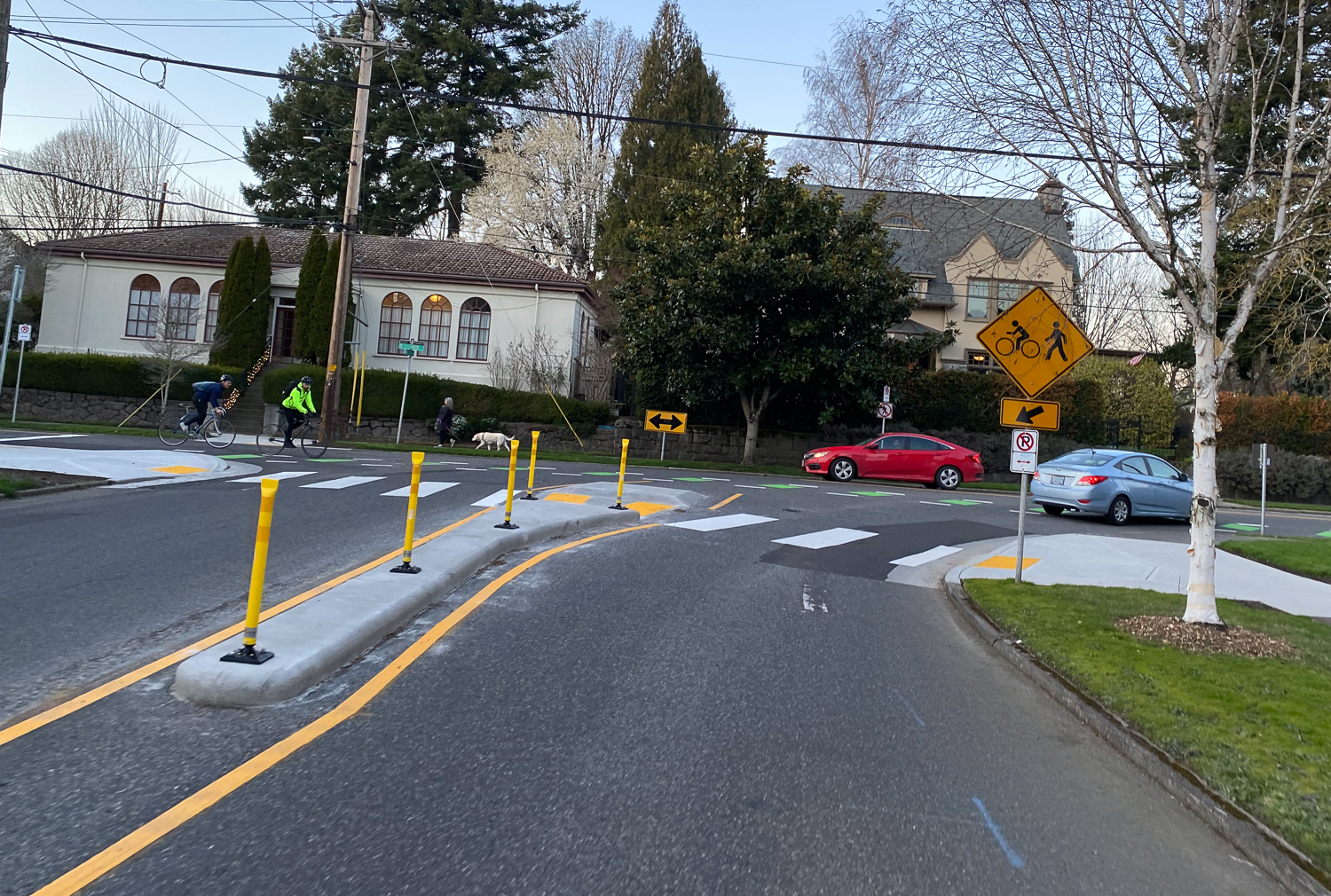
A big focus of the $150,000 investment was the off-set intersection of Tillamook and 21st. With high bicycle traffic volume on Tillamook and poor sightlines for people driving north-south on 21st, PBOT wanted to improve predictability, visibility, and safety.
I went out to see the changes earlier this week. Before we get to more photos, let’s recall what this intersection used to look like:

Advertisement
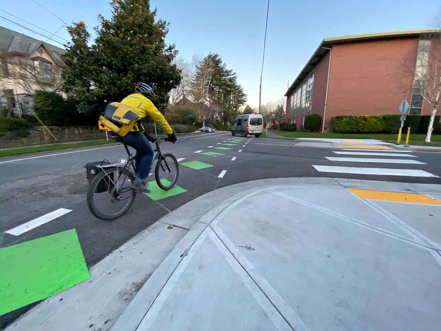

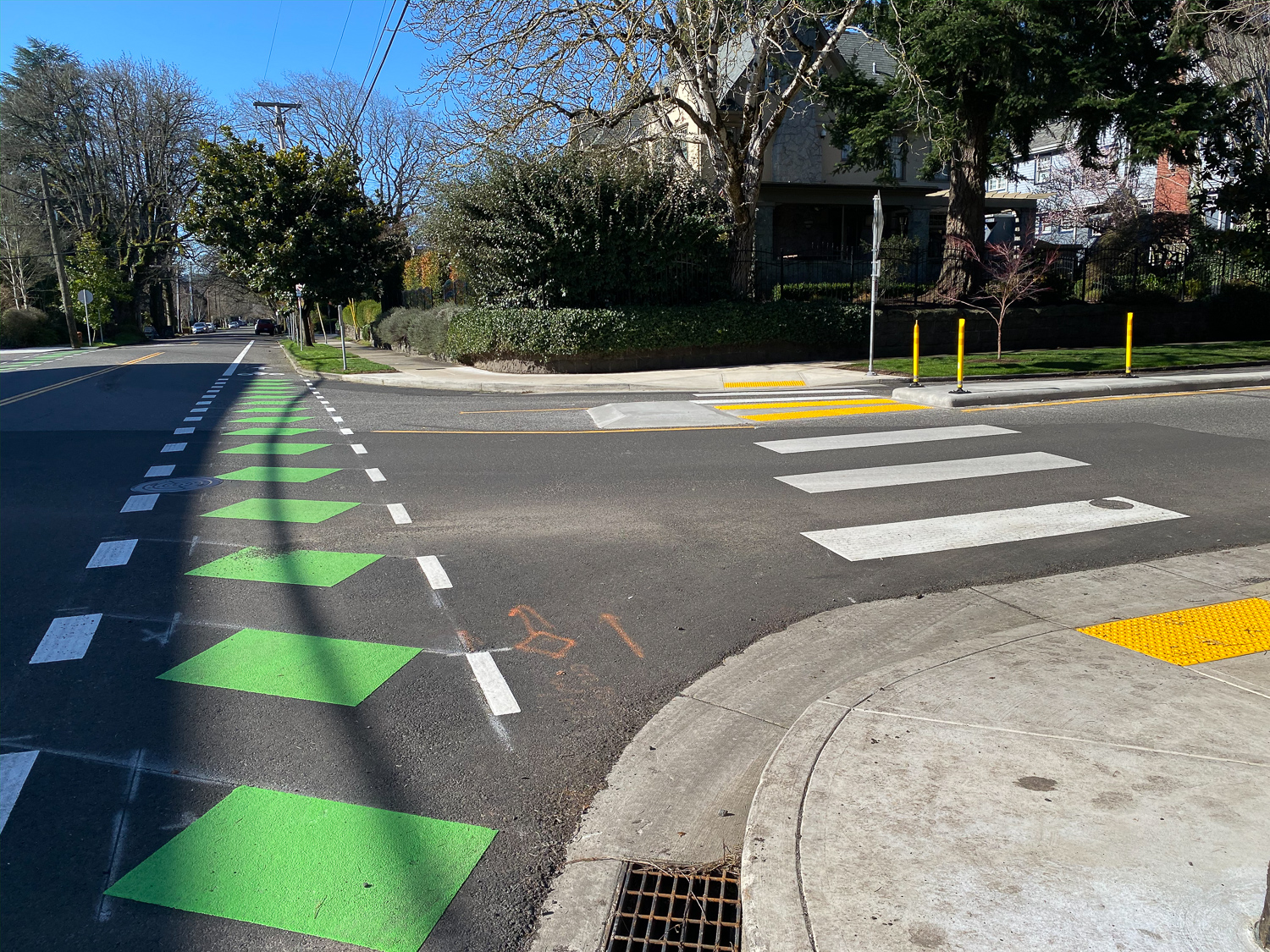
The first thing I noticed was that bicycle riders now have a direct line across the intersection; instead of the winding striping of before. Heading east, the corner has opened up due to the removal of a large tree and installation of new curb ramps.
PBOT has also tilted the green blocks in the bike lane. This curious treatment is intended to increase longevity of the green paint by angling it outside the wheel path of motor vehicles.

Before the intersection PBOT has installed median islands and crosswalks setback several feet away from the bike lane. These are wonderful not only for non-drivers but because they also slow people down as they approach Tillamook. In addition to the medians, there’s bright new, yellow caution signs that warn of people crossing ahead.
On the down side, those new medians might make it harder for people biking north-south (a relatively popular movement because 21st has a protected bike lane over I-84 just a few blocks south) who want to turn left onto the Tillamook greenway. There’s no turn lane and the medians make the left turn movement a bit more awkward for bicycle users.
Overall I found this to be a good update in re-establishing Tillamook as a street where bicycle riders are respected and more protected.
Have you biked or driven this yet? Would like to hear your thoughts.
Next up: A look at the new protected bike lanes on NW Naito and the protected intersection on NW Thurman.
— Jonathan Maus: (503) 706-8804, @jonathan_maus on Twitter and jonathan@bikeportland.org
— Get our headlines delivered to your inbox.
— Support this independent community media outlet with a one-time contribution or monthly subscription.


Thanks for reading.
BikePortland has served this community with independent community journalism since 2005. We rely on subscriptions from readers like you to survive. Your financial support is vital in keeping this valuable resource alive and well.
Please subscribe today to strengthen and expand our work.
This is SUCH an improvement over PBOT’s initial proposed design. I rode Tillamook on Monday and a car actually stopped for me. I hope PBOT does a speed study to show before/after changes. Portland has lots of offsets intersections like this.
I’ll have to check it out in person but just based on the photos I’m confused why PBOT spent all this money on a refuge island, new curb cuts, etc and still designed them so that the geometry channelizes car drivers at high speed turning right. I’m referencing the last photo in Maus’s article. It looks like a slip lane to me.
If we spent all this money removing a tree, adding new concrete, refuge island, etc, why not square up the intersection as much as possible?
Anyways, it may just be the angle of the photo. I’ll have to check it out in person.
I know I’m on a complaining roll, but I also wish PBOT would pick a single bike crossing signage/marking method (green bar with white edges) and stick with it uniformly.
At first glance saw that and thought the construction installing the crossbikes was drunk or something–which isn’t fair to the construction person. It was a deliberate PBOT design choice! Predictability is good
15 mph is high speed to you?
What…
Yes. Squaring things up also would improve an issue I see in the photos, and all over the City with new crossings—having the curb cuts and their tactile warnings not aligned with the crossing. The ramp slopes and tactile warnings give clues to people who need them which direction to walk. That direction should be straight–aligned with the ramp slope and perpendicular to the warning strip. If you can’t see, you can’t tell that you’re being launched off the curb at an angle to where the crosswalk is, and you’ll end up in the middle of the intersection instead of reaching the far sidewalk.
I understand it’s not always possible to have the entire crossing–crosswalk plus curb cuts at both ends–aligned perfectly, but often it seems like nobody even thinks about that when designing these.
The Department of Justice requires ADA ramps to be perpendicular to the curb.
That doesn’t change anything about what I said. That means considering the location and shape of the curve, and where the ramp and crossing are located, so that people going off the curb are directed into the crossing and towards the curb at the other end.
I understand that there are other factors that influence the curb configuration and ramp/crossing location that doesn’t always result in ideal results for the ramp users. But on the other hand, I also regularly see (on City projects) tactile warning strips installed at an angle to the crossing, where there’s no reason for that other than sloppy design or installation.
After Williams to NE 7th, it’s pretty interesting how much the traffic calming changes once you cross into Irvington.
Ooooh… a new type of marking! Exciting!
And it hasn’t even reached it’s final form.
I’ve use this intersection several times a week for the past 15 years or so. It’s a big improvement, but I wonder why didn’t they just put a crossing light there? It’s still an awkward intersection with poor sight lines, and I still see motorists whipping around the curve (north/south traffic) much too quickly.
I always tell my kids to cross 21st a block or two north, since they’ll have better views of oncoming traffic in all directions, and these changes at Tillamook don’t change my mind on that strategy.
FrogBoiler,
Could be other things but keep in mind they only chose to spend a very paltry $150,000 on this entire project. One signal costs at least $250,000 and they entail loads more engineering and complexity than just paint-and-posts.
I agree — big improvement, but not quite there yet. I ride the intersection pretty much daily, and find the medians very helpful in reducing speed. There remains ambiguity as to whether people on 21st or people on Tillamook have the right of way, and that creates ambiguity that we should try to avoid with infrastructure designs. Some people driving cars stop, while others continue through the intersection. Works for me as a relatively confident rider, but I would find it stressful getting my kids on their bikes through the intersection.
My suggestion: make it a four-way stop sign intersection.
Basic rules of the road state that all-way stops include the all way rider below the stop sign. If that rider does not exist, the other streets do not have to stop. Are you requesting warning signs to tell people on Tillamook that 21st traffic does not stop, the way it has always been? If so, PBOT has a number to call, 823-SAFE.
I interpreted his “My suggestion: make it a four-way stop sign intersection” to mean that he was requesting a four-way stop sign intersection.
And there ya go, another bizarre PBOT experiment. “Let’s do the green zebra stripes… off kilter by 35 degrees (takes a deep drag on a joint)… maaaaaan.”
but you don’t really design roads for a living, do you…
You often respond to comments by saying people lack credentials. It hasn’t been relevant yet.
There’s been quite a bit of speculation about what angling the paint bars mean. Your “less wear and tear” response makes sense. However, a recurring theme of people seeing new pavement marking by PBOT is “What does that mean? Every new project has a new type of striping/marking/design. It’s confusing.”
It could be a clue to PBOT that PBOT might do more to tell people what things mean when PBOT starts doing anything new. It’s not surprising that people are wondering if the angling means something. The fact that Jonathan–who knows as much about these things as just about anyone–didn’t know should tell PBOT something.
My bad. Pretendgineers are everywhere, but sometimes the comments are presumptive, frequently negative, and not inquisitive. It’s the primary reason I don’t comment so much anymore.
Several of the links I provided earlier reference the same design layout and were completed years ago. This form of marking orientation is not new, as anyone that has ridden Lincoln, or the other streets referenced, knows.
You say you don’t comment much anymore, but at the time of writing this comment you have 12 comments in this thread. Never mind the entire site.
But what does the diagonal zebra striping mean? What am I to infer from this as a road user? “Get sideways in the chicane?” This road marking is not informative.
There’s too many to read them all.
Okay, I’ve read all of Paikiala’s comments in this thread. I don’t see where he explains why the stripes are off kilter. Granted, I was speed reading, but still. If you see it, quote it so I can search the page and admit my error.
Several comments ago, paikiala wrote, “Apart from the increased visibility of continental crosswalks for drivers, placement of the stripes outside wheel paths means they need less maintenance”. So angling the stripes makes them parallel to wheel paths, meaning less wear.
Well, the green stripes aren’t outside the wheel track, but I maybe being parallel to wheel tracks count? They don’t exactly line up with the wheel track, but I can see how making them diagonal would increase the life of the paint. Still looks really odd.
I didn’t say the angled stripes were a new thing with this project. I said, “PBOT might do more to tell people what things mean when PBOT starts doing anything new.” If PBOT had done that in those earlier project when the angled striping WAS something new, then there might be less confusion when they’re done on subsequent projects like this one.
Your argument is a straw man. I never said I was a road designer, nor was that implied by my statement. What I was implying is that this is clearly over-the-top, free-association design. Which is very often influenced by the devil’s lettuce.
I’m referring to the green zebra stripes here, not the white ones. But you do you. It’s funny.
PBOT hasn’t been consistent with bike infrastructure yet, why start now?
On the positive side, PBOT has been consistently inconsistent.
this is a marginal improvement for people who are already comfortable cycling and does little to disrupt people used to driving quickly on 21st. To actually provide a bicycle route that will work for 8-80, it should have been a 4-way stop (to save money) or a half signal (less than half of $250,000 for a full signal) that stops traffic on 21st and lets bikes/peds cross using a ped head.
You’re asking for a beg button?
Or just a stop sign for 21st Ave, and no stop signs for traffic on Tillamook St.
If we were at 16% bicycle mode share that would be a no-brainer.
And perhaps it’s also a no-brainer that if PBOT *had* given better priority to bicycle traffic over the last 10 years, we would be at 16% bicycle mode share now!
Ted Buehler
I bike through here on my commute everyday. I was a little skeptical during construction on what value it would bring, but I do think it has improved the intersection. I’ve found that drivers (northbound in particular) are slowing as they approach the channelization and are more inclined to stop to let you cross. I am appreciating the more direct line over the green stripes, rather than the wiggle I was doing before where I crossed at the shortest point (now the crosswalk) and then rode along the curve.
A four way stop would not work here because of the intersection geometry. To actually see all the legs you have to be part way into the intersection. (SB cars on the northermost leg, for example, can’t see anyone stopped at the Tillamook sign heading EB until they’ve left their stop sign and are proceeding into the intersection. As for squaring the intersection, I think you’d have to take a big slice of the east side property to square things up — which i’m fairly sure is a school.
It sure seems to me that if the goal is to reduce the number of cars using a neighborhood greenway that the simple and effective solution is to install diverters. I can’t understand why PBOT isn’t doing so more often as getting one person who plans to drive the length of this stretch to just go drive on Broadway has the same impact as getting 25 people to drive on it for one less block. Focus on getting the through traffic to drive somewhere else and things will be far more pleasant for all other users.
While I generally support diverters, there aren’t many other options for cars getting to Fremont from SE. 15th and 33rd are often congested and there’s nearly two miles between the two. 24th and 28th don’t continue past Broadway, so this one of the few ways for several miles.
I do bike Tillamook mostly on the way home usually and have often wondered why the City hasn’t shifted more stop signs to north/south streets before. Seems like some of these improvements could’ve been achieved for $100’s, not $150k.
I was referring to on the tillamook greenway not 21st when suggesting diverters to reduce motor vehicle traffic counts.
PBOT does not install diversion on greenways that are meeting the under 1,000 daily trips ideal goal.
How do you know this? Is this public information? Or are you secretly a road designer?
The city’s report on greenways says that Tillamook is seeing 1250-1400 motor vehicles at some of the count point. The city says in that report that they would consider diverters at 2000 vehicles per day. It seems to be driven by keeping costs to a minimum rather than because the diverters are not needed. We need to give enough funding to our neighborhood greenways to actually get motor vehicle counts down under 1000, lower if possible.
PBOT policy is to turn stops after traffic calming has been installed do reduce the likelihood that people driving adopt the street for through travel.
I would like ranch dressing with my word salad please.
As a pedestrian primarily this is a huge improvement. The marked crosswalk, the median are huge improvements. I’ve avoided this intersection when walking at night or even jogging during the day because you can’t tell if drivers can see you. It sounds like some cyclists are disappointed in the execution but I’m toasting PBOT. Tonight.
smart cyclists are going to take the lane here; eastbound, it gives you more distance from cars going north in the slip lane, and it prevents close passes in both directions.
Jonathan: Any word about the diverter PBOT was planning on testing between MLK and Williams? That section has gotten gradually worse traffic wise over the past few years.
Also, is there any chance that PBOT might consider a diverter in the 20s? I live just off Tillamook in Hollywood, and use it on a daily basis. I like the improvements that have been installed in the past few months–especially the turned stop signs–but am already seeing signs that some motorists are seeing the route as a superior alternative to Broadway during rush hour.
The diverter east of Williams is on hold until the effects of the bike box at MLK can be measured. With the new developments, the diverter might have pushed traffic to the Rodney greenway.
Phase one of the Tillamook greenway went to 28th. The volumes measured before the project did not trigger diversion. All projects include post construction data collection about 3 months after speed bumps are built, and all changes will be considered. Phase 2 of Tillamook, 28th to about 47th, can also look at ways to deter use by traffic avoiding Broadway.
https://www.portlandoregon.gov/TRANSPORTATION/article/683810
Thanks for the thoughtful reply. I do have one question regarding your reference to the Rodney greenway, however. What traffic did PBOT fear would be pushed to Rodney? Motorists traveling east-west?
The former significant traffic on Tillamook was coming south on Vancouver and going east to go south on MLK. The new traffic is a result of the new apartment complexes recently built and under construction.
Winner!
https://goo.gl/maps/eiomShCdsp18SaMs6
https://goo.gl/maps/KRiPd84mDTPRsZNz5
https://goo.gl/maps/v3GzW8UDTNJKKKhCA
https://goo.gl/maps/GDqEEYCneA18KWoF7
https://goo.gl/maps/VcgaLmpFxKnPsqfu5
https://goo.gl/maps/KK2qNRFhd5Lo7Fhj6
Apart from the increased visibility of continental crosswalks for drivers, placement of the stripes outside wheel paths means they need less maintenance.
Woah. That’s interesting. Sorry I speculated. I need to stop doing that. Editing the post now. Thanks for the comment paikiala.
Nice set of links, Paik.
I didn’t know there was a tennis court above Golden Pliers!
Ted Buehler
I ride thru here most days, usually N-S on 21st in the mornings, and one of the major issues I’ve experienced was drivers passing dangerously late/too close to the intersection with Tillamook and then cutting over real quick around the curve….that median splitting 21st should work wonders to limit that activity.
I also cross West-East in the afternoons pretty frequently, and its already been a treat how often people now yield for bikes!
On a frustrating note…Tillamook was totally blocked between 20th and 21st this AM for curb cutting for ADA ramps. What’s the point of these facilities if they’re constantly blocked? PBOT would never allow that on an automobile arterial.
I bike through this intersection a few times a week (eastbound) and have observed that the change is affecting driver behavior, with people in cars slowing down and appearing to expect other road users. I feel way safer crossing here now.
Don’t crash the forum! 😉
Virtually every design shortcoming on every road in Portland was designed by someone who designs roads for a living.
I ride this twice a day on my commute, and I think it’s a very marginal improvement. My main observation was that this new treatment makes one thing (path of travel) more predictable, but it introduces another kind of ambiguity by using the green bike crossings. My understanding is that these green crossings don’t offer any additional rights or protection to cyclists (that is, they don’t require drivers to stop for cyclists in the way that normal crosswalks require them to stop for pedestrians), and in my experience, they just confuse things. Some drivers ignore them altogether while others treat them exactly like white pedestrian crosswalks. Honestly, I wish they’d done a 4-way stop at that intersection instead.
He’s implying that the cars will be going 15 mph. Which is very imaginative.
paikiala–I looked through these examples in regard my comment about how I wish PBOT would pay more attention to aligning ADA ramps and tactile warning strips with crosswalks, so that visually impaired people are led directly into the crosswalk and towards the ramp at the other end of the crosswalk, instead of being launched at angles out into traffic outside the crosswalk.
Your examples prove my point that PBOT isn’t doing a good job with this. There’s no consistency from example to example, or even within some examples from one end of a crosswalk to another. Sometimes the tactile warnings align with the crosswalk but not the sidewalk, sometimes the opposite. Sometimes the tactile warnings are missing entirely. Sometimes curb ramps are provided at one end of the crosswalk but not the other, so someone in a wheelchair can get into a crosswalk at one end, but can’t exit it at the other.
Sometimes (Klickitat/Alameda is an example) curb ramps are provided that not only don’t have a corresponding curb ramp at the other side of the street, they don’t even have a sidewalk there, so you’re just led into a solid curb with landscaping!
Sometimes (Interstate/Skidmore is an example) the curb ramps are at drastic angles to the curb. You told me, “The Department of Justice requires ADA ramps to be perpendicular to the curb”. So those ramps are apparently violating Dept. of Justice standards.
These examples that you provided show the same pervasive problems that I see constantly and that led me to make my comment that PBOT needs to take more care with designing and placing curb ramps and tactile warnings.
Why is there a brand new utility poll in the middle of the brand new curb ramp, positioned to block the view of pedestrians?
That’s so obvious once you pointed it out–can’t believe how many times I looked at these photos and didn’t notice, especially when I was commenting about how PBOT should take more care locating ramps to they’re more usable and safe.
And bad–in the top photo, it’s right in the middle of the sightline between the person approaching in the street (the camera view) and someone who’d be ready to cross. And of course in the way of people, especially those approaching from the fire hydrant area to use that ramp to cross.
It’s actually just cropped out of the before picture.
https://www.google.com/maps/@45.5374491,-122.645005,3a,75y,116.42h,86.68t/data=!3m6!1e1!3m4!1suqNsSLfISEsrIwfDI7pjEg!2e0!7i16384!8i8192
Love this improvement. Thanks PBOT!!! ❤️❤️❤️❤️