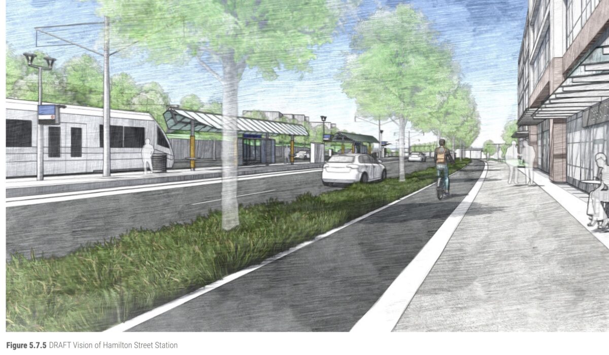
TriMet’s new SW Corridor light rail line will have a vast impact on how we get around the region — not only for where it will take us (without a car), but for how it will change the streets and neighborhoods it runs through.
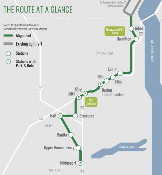
With the release of the project’s draft Conceptual Design Report this week, we now have the clearest view yet on what those streets will look like. If you haven’t followed every twist and turn of the planning process so far, the design report is a great way to catch up. If you ride a bike on or around Barbur Boulevard (a key connector, given the dearth of flat and direct streets in that part of town) you’ll be interested to know that the 12-mile, $2.8 billion project will add more than six miles of new cycling facilities — including over those two annoying and infamous viaducts south of Capitol Highway.
The design report reflects years of input and work by project staff. It’s just a draft however, and TriMet still needs public feedback to polish things off before releasing the final version later this summer. They’ve released an online open house where you can learn more and share comments.
Advertisement
Before sharing what caught my eye in the 220-page report, let’s hear what Ramtin Rahmani thinks.
“I wish TriMet took the safety and needs of pedestrians and cyclists more seriously on this stretch of road.”
— Ramtin Rahmani
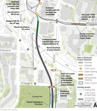
Rahmani lives in southwest and is on the project’s community advisory committee. Speaking for himself (not the committee), he said he feels like TriMet has done a good job listening to feedback and making changes thus far, but one area he’d like them to change is in how the new line will tie into the downtown Portland street grid.
“TriMet plans for a paint only bike lane [at Barbur/Naito and 4th] right as many bicycle commuters are reaching downtown Portland or leaving Portland,” he shared in an email today. “From my own personal experience, a bike route is only as good as its worst segment. I wish TriMet took the safety and needs of pedestrians and cyclists more seriously on this stretch of road. This is the flattest approach to OHSU and will also be used by many future bike commuters to reach OHSU via the SW Corridor connector. I’d like to see them work with PBOT and the Fire Department so that we can have, ideally, a curb protected bike lane.”
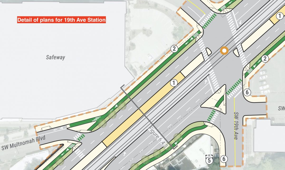
Rahmani’s other concern is the safety of people getting to the new line. He wanted raised crosswalks near stations and platforms, but TriMet doesn’t plan to install them. Slip lanes that remain in the plans — line the ones at Naito and Barbur, and SW Multnomah and 19th — are also something Rahmani is worried about because of potential turning movement conflicts. “Building a slip lane is antithetical to PBOT’s vision zero goals, and PBOT staff themselves have acknowledged that slip lanes should be minimized in use as they prioritize automobile movement over safety.”
Here’s what caught my eye in the 220-page report.
Raised Protected Bike Lanes
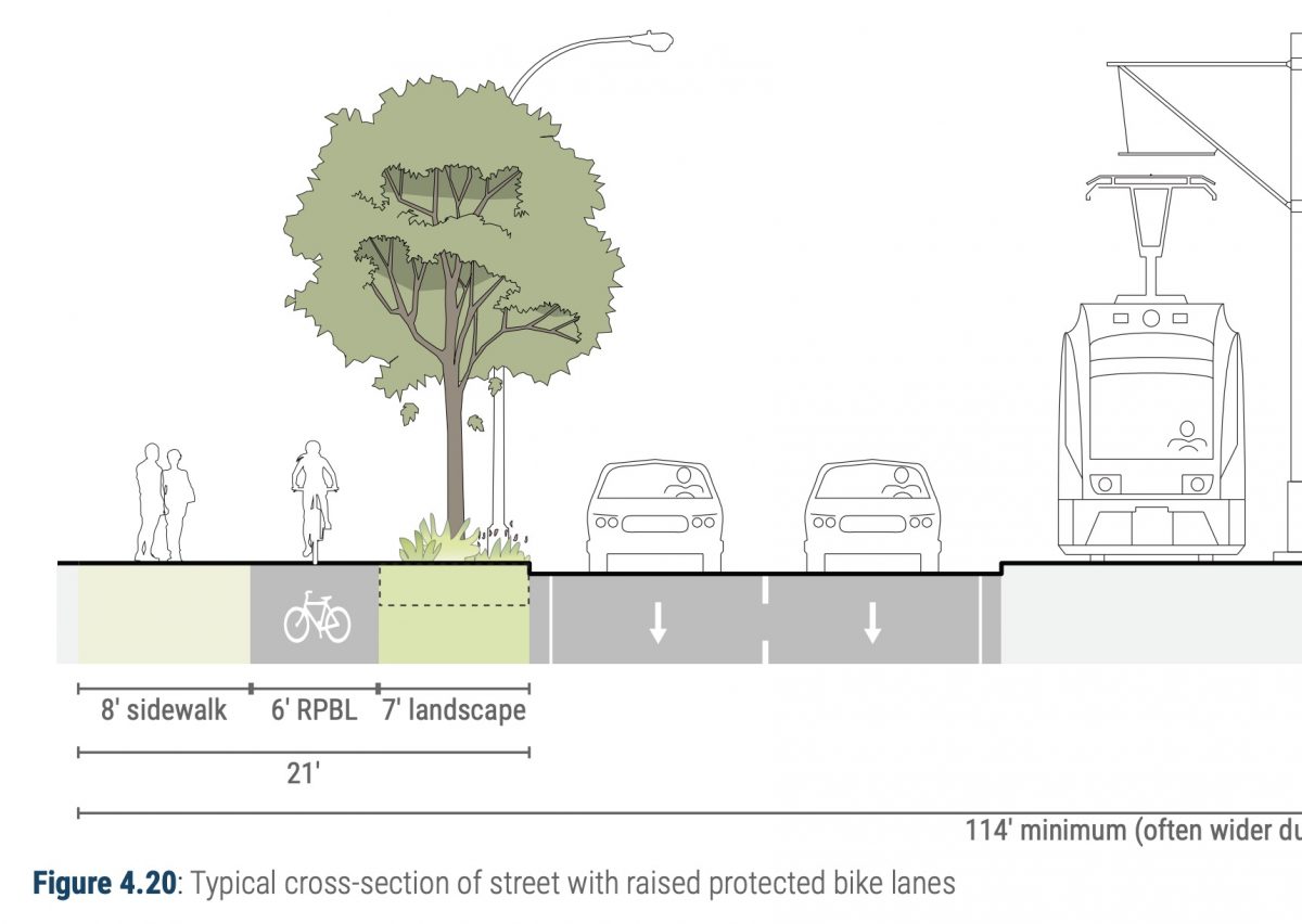
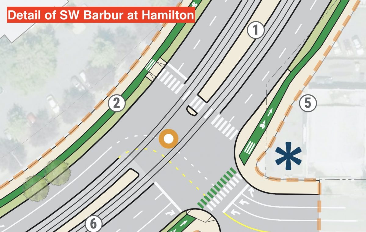
TriMet will add RPBLs (rolls off the tongue doesn’t it?) along the four-mile stretch between Barbur Transit Center and Naito Parkway. These lanes will separate bicycle users from other traffic by a “curb-protected furnishing zone”. That furnishing zone will include vegetation, lights and utility poles. Once complete, the new bike lanes will provide, “A seamless and continuous connection through Southwest Portland that serves a number of neighborhoods along the corridor,” says TriMet.
Here’s how they look from above:
Advertisement
Protected Intersections
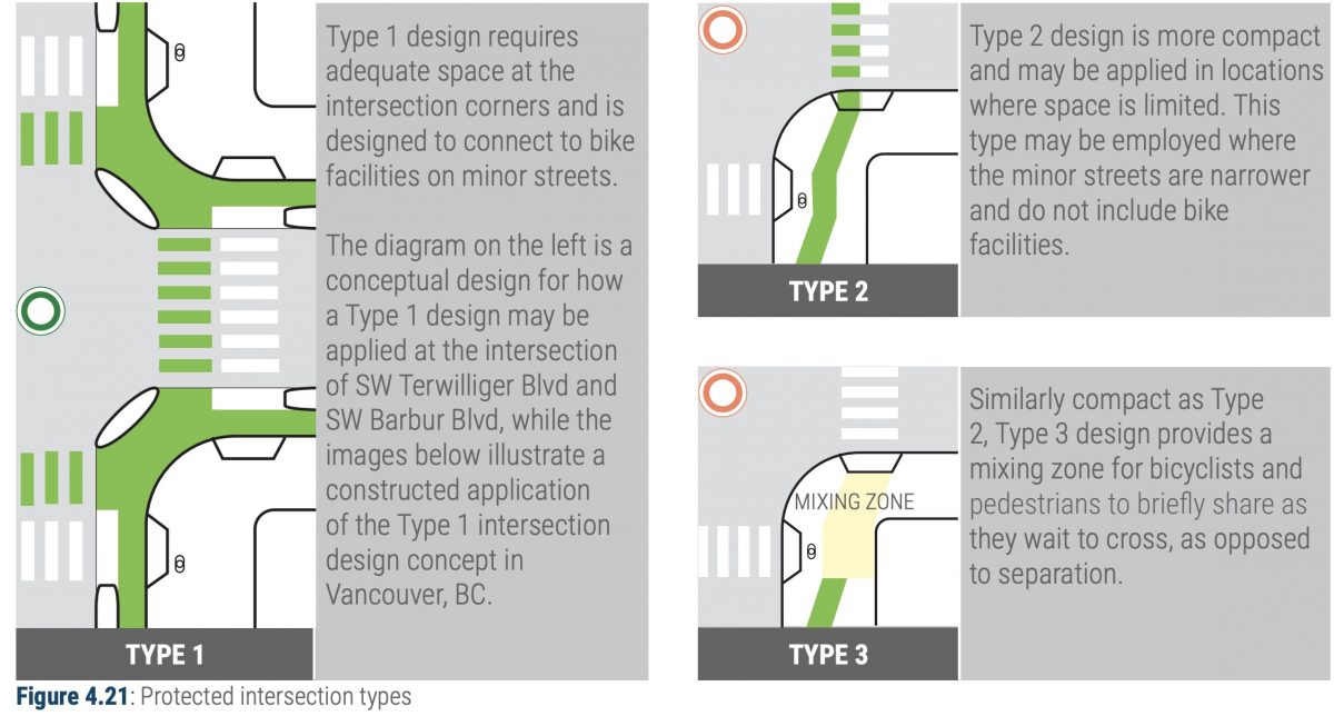
The project calls for 18 protected intersections where bicycle riders and other vulnerable road users will have space away from car and truck drivers. Five of these will be fully protected (“Type 1” in the plans) and 13 of them (Type 2 and Type 3) will have less protection because of limited space. To get an idea of what the Type 1 versions look like, roll over to PBOT’s work at NW Thurman and 20th.
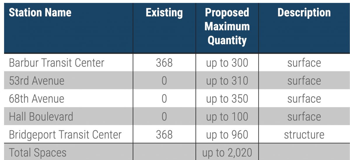
2,000 Car Parking Spaces
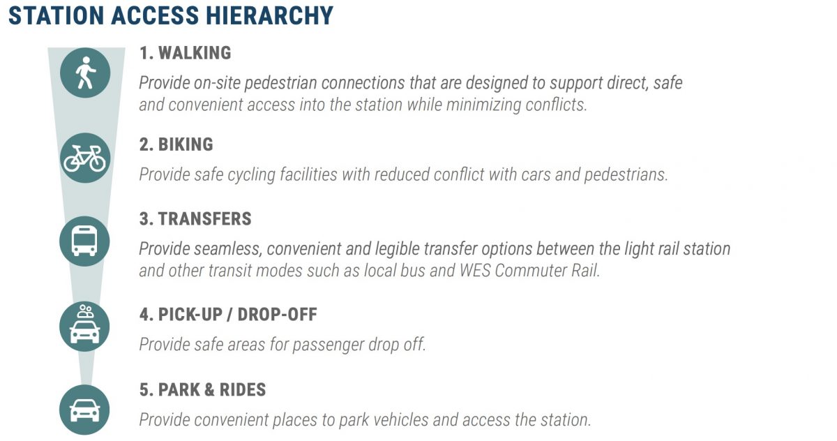
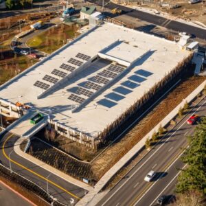
It’s wild to me that in 2020 we still invest so much money to store people’s large personal vehicles. TriMet plans to build three new parking lots and add hundreds of spaces to existing ones. All the new parking would be added from Barbur Transit Center south. There could be nearly 1,000 parking spots at Bridgeport Transit Center. All this, despite the quaint “Station Access Hierarchy” graphic in the design report.
Vermont and Newbury Viaducts Rebuilt
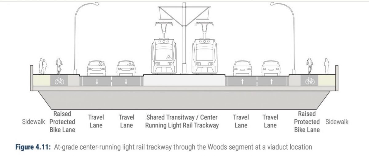
The bike lane gap on Barbur over the Vermont and Newbury viaducts south of Capitol Highway have been a very sore spot for bicycle riders for many years. This project will finally fix that with new structures and dedicated bike lanes.
A Few More Visuals
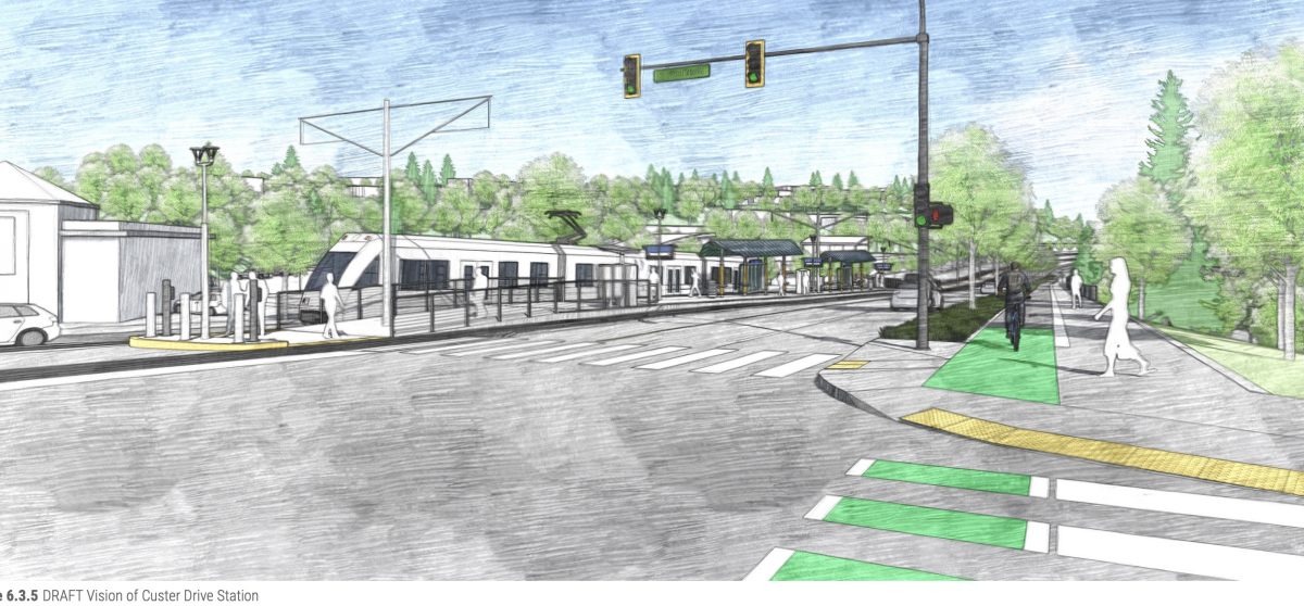
A protected bike lane at SW Custer Drive station:
Detail of design for Barbur at 19th (where Rahmani warned of a dangerous slip lane):
Before and after of SW Barbur at Gibbs:


To learn more about this project, the community advisory committee meets tomorrow (2/6) from 5:30 to 7:00 pm at Tigard Public Works Auditorium. You can also visit the online open house and download the full design report here. TriMet will also present the report to the PBOT Bicycle Advisory Committee at their next meeting Tuesday (2/11) at 6:00 pm at City Hall.
SW Corridor is expected to begin construction in 2022 and open for service in 2027.
— Jonathan Maus: (503) 706-8804, @jonathan_maus on Twitter and jonathan@bikeportland.org
— Get our headlines delivered to your inbox.
— Support this independent community media outlet with a one-time contribution or monthly subscription.



Thanks for reading.
BikePortland has served this community with independent community journalism since 2005. We rely on subscriptions from readers like you to survive. Your financial support is vital in keeping this valuable resource alive and well.
Please subscribe today to strengthen and expand our work.
This is really exciting news! I live AND work along this corridor and can’t wait for this to happen (though I’m not holding my breath, tbqh). FWIW, I live right around the corner from the proposed 19th intersection, and there aren’t a lot of autos turning right onto 19th there ,where there’s already a slip lane, because it’s easier to turn right two blocks earlier on SW Garden Home, which is honestly going to be a lot more of a concern. It’s uphill heading North and autos tend to take that turn VERY fast because it’s far less than a 90-degree turn and, due to the hill, cyclists will be going quite a bit slower.
I’ll echo Karstan’s comment, but from a different angle. I cross at 19th everyday going westbound, continuing on to the Multnomah bike lane. I can’t use that crossing easily going east, because that ramp from Barbur to Multnomah is one way going west.
Instead I cross Barbur at 21st, along with lots of other traffic. It will be interesting to see how that intersection is handled once there are rails down the middle. Will it be a full-fledged intersection with a light? Will it be closed to traffic going across Barbur?
The intersection of 21st and Spring Garden is also problematic: sight lines aren’t good, traffic coming off Barbur goes fast, and it’s not a 4-way stop.
I know it’s Bike PORTLAND, but what’s with the weird jog near 217, I found myself asking? Why, it’s to hit the all-important Elmhurst stop! A bit gerrymandered, eh? I dunno, smells like compromise. Nearest stop to Tigard Transit Center – 1/4 mile away. Far enough away that the walk will be annoying, and close enough that everyone will wonder forever why they didn’t just go all the way.
Construction cost is once; living with a project is forever. Carve a lane from 99W and do this right. Hit downtown Tigard too, assuming those business owners aren’t ass-backward numbskulls afraid of the “crime train.” (Actual epithet against proposed MAX extension into sorry-ass Vancouver once upon a time.) Or even if they are. It’s probably cheaper too. Taking a secondary alignment that costs more in order to preserve car lanes = paying for cars = a car project.
Missing Tigard TC is a huge mistake. The WES corridor is an obvious candidate for a future MAX line, at last between Tigard and Beaverton. Being able to connect the lines in Tigard is critical.
Igor, I take that same route and while I like to avoid riding on the sidewalk, the signage on Multnomah (heading East) seems to indicate that cyclists should cross and use the sidewalk up past the Safeway, so that’s what I do. I find it’s much safer than trying to Frogger across Barbur at 21st.
Ugh, don’t know why the comments didn’t thread.
I’m concerned about PBOT’s affinity for the “type 1” protected intersections. If they’re anything like what they’ve done at NW 20th & Thurman (an intersection they point to as an example), I think there’s reason for worry: these “protections” are set below grade and way too narrow, with tight radius curves, all of which mean slow, tenuous, and unsafe biking. Riding through those feel like biking through a slot canyon or something. I’d encourage others to check those out, particularly the ones on the South side of the intersection, traveling Eastbound on Thurman: I’d so much rather be in the street than in one of those.
I won’t just be negative, but will offer constructive feedback on what would make those feel better to me:
1. If you’re going to sink the bike lane below grade, make it wider than you have here, and increase the curve radius.
2. Wider is always good. However in the absence of that, a better feel here would be to bring the green bike lane up to curb grade; this will make it feel less constrained and provide options if one has to swerve around something. In the design at 20th and Thurman, bail-out options are limited for those on bikes.
Would be great to have some sort of bike crossing signal for turning left onto Barbur from Hamilton. The light often doesn’t change for bikes, and you barely get enough time to get across the 4 lanes. Hamilton is a popular bike connection between Terwilliger and Barbur.
Not sure if that is a PBOT or ODOT signal but in my experience an email is enough to get them to try and tune the sensors to also capture bikes. I’ve done it successfully with Washington County on multiple occasions.
Keeping four motor traffic lanes on Barbur will keep it much less non-motorized traffic friendly than Interstate which was reduced to two. I grew up out in SW so get that there are not the options out there that N PDX has for the “auto-butts.” But is sad we still build….lane space, parking, slip lanes for something we know is killing us…both in a snap of the fingers and slowly like frogs in heating water.
On the plus side this project gets protected bike lanes into SW as well as a Transit Only corridor for both light rail trains and buses. This stuff is very expensive to build but can be transformative. I hope there is an aggressive plan from BPS for station area up zoning at the Portland stations; its was very slow in coming on Interstate.
TriMet is throwing more crumbs to the peanut gallery, there’s really nothing to see here, please move along!
You’re saying that the improved bike lane is a crumb?
Some people just cant be pleased.
Build the improvements to PCC only with Bus Rapid Transit instead. Light rail is a development tool without Transit Oriented Development it’s a waste of money. In the segment through the terwilliger curves redevelopment is impossible because of the existing geography, redevelopment could occur from Taylor’s Ferry to 53rd but it will be slow without rezoning, that area is in Portland so I am most hopeful about redevelopment. Once you pass 53rd you enter Tigard and the line weaves through a bunch of light industrial land that won’t service commuters to those businesses because they would be coming from high rent downtown and won’t be able to support housing for commuters to downtown. Bonus, no need for additional parking. Save a few billion and get housing built on the existing lines like the original promise of the blue line and to bolster ridership on the Orange which never met estimated ridership. Invest in large Ebike subsidies to increase ridership on safer Barbur Blvd through the hilly terrain of SW.
Tigard is in the process of rezoning the Tigard Triangle into Transit Oriented Housing. One four story apartment building just got done and several more are about to start construction. Your assumptions of what’s going on in Tigard are incorrect.
That is a fair criticism. If the line we’re extended into the Tigard Triangle and was BRT the project could cost somewhere near a billion less dollars. Looking at the EIS ridership in 2035 the line is an 8 percent, 15,000, increase in ridership over the no build condition. Assuming BRT doesn’t increase ridership beyond the no build, this removes a lot of infrastructure repair costs like bicycle improvements from the calculations, we’re still paying $65,000 a rider in initial capital cost to build light rail. Light rail requires density that the corridor lacks.
Also, many of us live closer in and work out in this area you are dismissing. Pushing the light rail out further does more than you think.
A bus could easily serve those needs at a much smaller cost.
I’d agree with you if Portland’s past record on BRT projects wasn’t so dismal.
A good BRT system uses a dedicated right-of-way like light rail at a fraction of the initial infrastructure costs, but there seems to be a local tendency to cut costs (value engineer) by making the BRT continuously mix with traffic as on outer Division, substantially reducing any gains in avoiding congestion that might be made by having dedicated right-of-way. The operational costs of BRT versus light rail is about the same, as the driver and maintenance personnel costs are the biggest issues, and BRT vehicles don’t last as long and have to be replaced more frequently.
BRT on Barbur would only be time-competitive if it has dedicated ROW. That means adding two lanes to the corridor. By the time you do that, you’ll be spending nearly as much as this LRT project.
I actually take the opposite view on this project. This should be a tunnel from Duniway Park to Barbur TC, with Subway stops at OHSU, Hillsdale, and Multnomah. If we are going to build rapid transit, it needs to be fast, and it needs to serve destinations that will add density.
Not going to happen after Trump re election. Who would really like the long climb back out of Portland November through March, anyway? Oh well, I guess the boatloads of extra property tax money from TOD rezoning will be delayed.
People on e-bikes will crush that “Long Climb” out of Portland 24/7/365.
Tri-Met is missing a huge opportunity with the framing and design of the Gibbs street station and Marquam Hill access. The description of the OHSU Access is either a PEDESTRIAN funicular or elevator and skybridge, with “ample bike parking at the station.” It it obviously framed this way because they want the funicular, which is pedestrian only. The elevator option is significantly less expensive and not as unique. They also want to control access.
By contrast if engineered correctly the elevator could be a 24 hour facility that gets bikes up the hill where bike parking would be placed all over campus. Between this new facility and the Gibbs street elevator it would lift bikes nearly 200 feet in elevation. This would be a huge gain for SW and a huge tourist draw with expansive views. If we are ever going to boost our mode splits we need to think creatively. Building for only pedestrian Access would be a huge loss.
I’m also interested in where funding will come from for all the access improvements needed. The map of needed bikeways and sidewalks to get to Barbur is expansive. Considering the Capital Highway remodel costs $25 million a mile, I see $100s of millions of unfunded infrastructure needed to just to access a newly remodeled Barbur. Even At PBOTs current rate, this will take decades.
I’m confused about the slip lanes discussion (Multnomah/19th). That design detail graphic seems to show the existing slip from Barbur onto Multnomah being fixed (partially) with a curb forcing drivers to slow and turn, which isn’t the case now. Similar with 19th. These could be tighetned up even more, but they don’t look like what I’d call “slip lanes.” Am I missing something?
That’s a lot of cement. It is carbon-neutral?
Carbon neutrality is a misnomer. Example, Ben and Jerry’s ice cream is manufactured in one location on the globe, but sold around the globe. The only conclusion is that a tremendous amount of fossil fuel is spent to transport it. But, hey, they are carbon neutral, so it’s okay.
Exactly. It’s a marketing term. Nearly ANYTHING consumption based has a negative impact somewhere.
This is genius.
TRIMET should build rails above ground so they can go at a faster speed. Many of us will continue to drive because riding the max takes too long because they operate at street level. Raise my taxes if need be but building above ground is much better than at street level
Most of the corridor would be best served with a tunnel.
I REALLY wish Chloe Eudaly would reconsider her stance on going from 4 lanes to 2 w/in the Portland City Limits. The ONLY thing that will get people out of their cars in SW is making it more difficult to drive. It is arguable the reduction of lanes on North Interstate is what has made North Portland the bike hub for the community it is. Instead I still see this as a car project with a fancy train and some improved bike/walk facilities only 5% of us will use. As should be so obvious there is a closely abutting freeway with plenty of lanes for cars directly w/in a stones throw from downtown all the way to Tigard. Why be so stubborn and redundant with more lanes for automobiles? This project should be transformative, by retaining 4 lanes it is sad to know it won’t be.