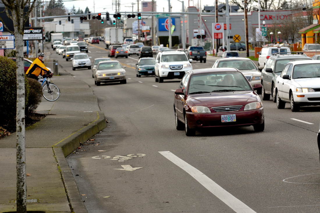
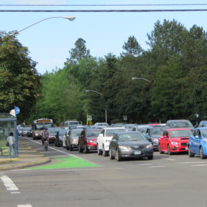
(Photo: J. Maus/BikePortland)
Washington County is growing fast. So too will a host of other problems (congestion, bad air, obesity, social isolation, injury and death) if they don’t encourage more people to stop driving. With wide roads that have ample right-of-way up for grabs, there’s vast potential on the west side of our region to make transit better.
But before people can ride transit, they have to get to it. That’s where the county’s First and Last Mile project comes in.
First and Last Mile is a Washington County planning effort that started a year ago. It aims to inform a forthcoming report that will, “identify a range of potential projects, programs and policies that would support more people to use transit for everyday trips.”
Currently about 600,000 people live in Washington County and it’s one of the fastest growing parts of the state with one resident and 1.3 new jobs coming to the area every hour in 2017. Unfortunately, only a precious few of them — less than 4% — use transit to get to work.
Advertisement
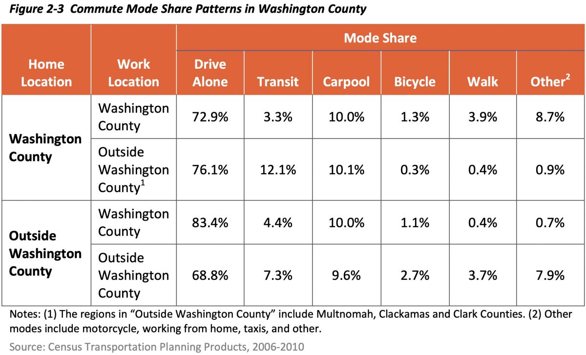
Through First and Last Mile, Washington County staff have been assessing the situation and reaching out to the community to find out what type of new programs, policies and projects might get more people to get out of their cars and onto bikes, scooters, their feet, and ultimately, the bus (or light rail).
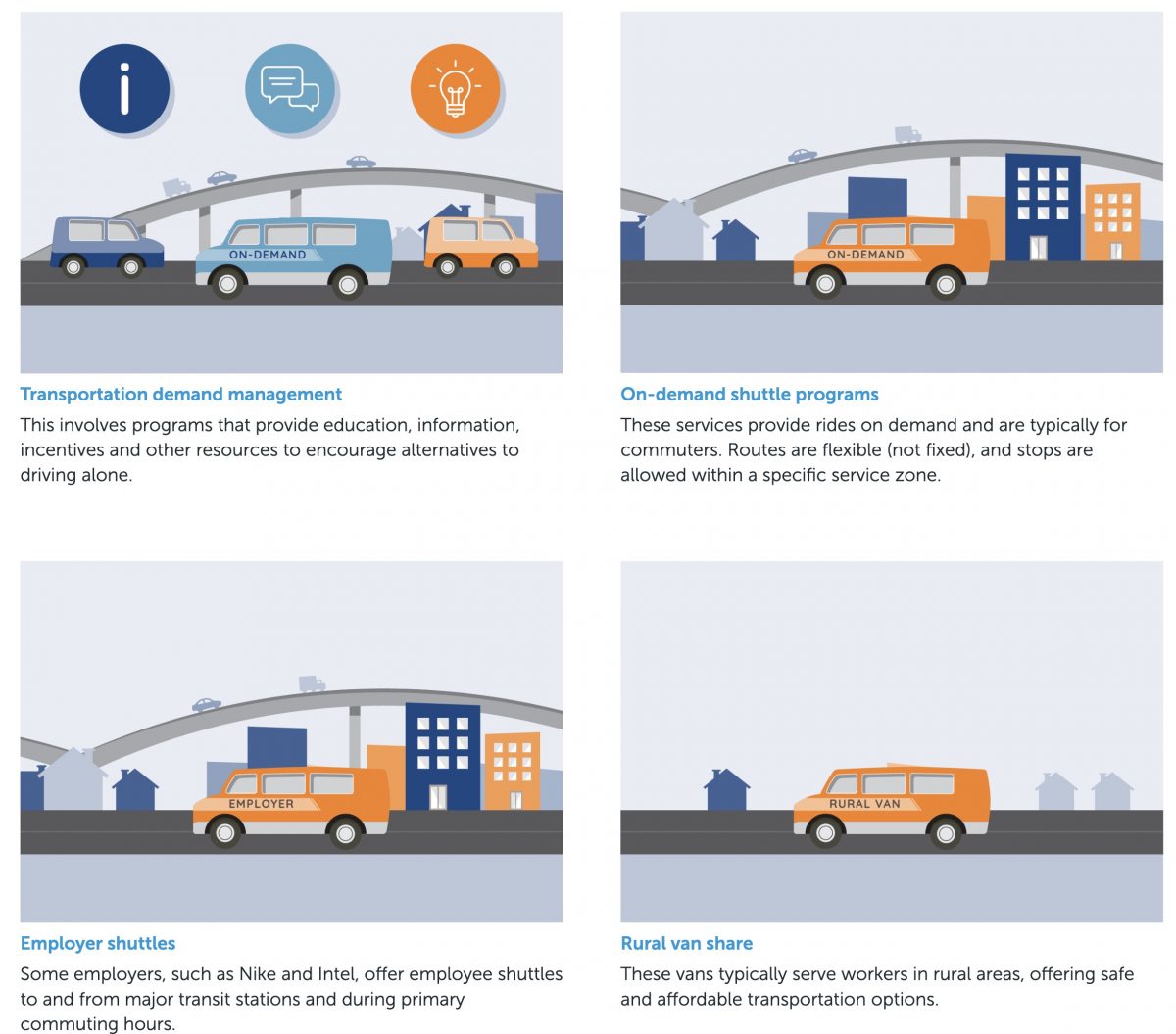
One of the policies on the project website mentions “slow speed networks” which would be streets where bicycle and scooter riders would feel more comfortable sharing the road with drivers. That’s hard to imagine if you’ve ever tried to use Washington County’s high-speed arterials. The project website also has many ideas about how to encourage alternatives to driving; but there’s not much on how to actively discourage car use.
By Washington County’s own estimates, in order to meet their climate and transportation goals, they must triple transit use in the next 20 years. The evolution of car culture is already so advanced in the county that it will likely take much more than soft encouragement to get people to change behaviors.
If you use roads in Washington County, I strongly suggest you check out the online open house and share your feedback. They plan to wrap up the comment period and planning by the end of this year.
(NOTE: I’ll be in Washington County tomorrow (10/30) to check in on WashCo Bikes and will definitely be checking out other stuff along the way. Stay tuned for a report!)
— Jonathan Maus: (503) 706-8804, @jonathan_maus on Twitter and jonathan@bikeportland.org
— Get our headlines delivered to your inbox.
— Support this independent community media outlet with a one-time contribution or monthly subscription.



Thanks for reading.
BikePortland has served this community with independent community journalism since 2005. We rely on subscriptions from readers like you to survive. Your financial support is vital in keeping this valuable resource alive and well.
Please subscribe today to strengthen and expand our work.
I bike along the route where that stoplight is on my way to the max, and that street, Lombard, is very accommodating to cyclists. Beaverton’s problem is it is difficult to get east-west, but north-south is well done. Supposedly Allen from Murray to 217 is being redone and will incorporate bicycle lanes.
Do you mean north / south in downtown Beaverton or all of Beaverton ?
I find the opposite to be true in central Beaverton: north-south routes are where I have difficulty, especially to get across Farmington. The bike-friendly streets north of Farmington don’t align with those on the south side of Farmington.
– Lombard sort of works, but the bike lanes come and go on the south side.
– I wouldn’t consider Hall/Watson bike-friendly because the bike lanes disappear between 5th and Allen (and the southbound approach to Farmington is also wonky for cyclists).
– Murray at least has a bike lane in front of Valley Catholic now, but … it’s Murray. Sooner or later you gotta make a left turn across it, and best wishes on that.
I legit amsterdam left on Murray only. And Walker. And quite a few other roads in Beaverton.
That photo is not in any way a “typical Washington County scene”; it isn’t even typical of a Beaverton scene really – if you have 2 brain cells you can figure out a fairly safe path. Bike lanes in town are pretty good in Washington County for the most part but sometimes they do have leaves/branches in them from the trees. Bike lanes on the country roads would be nice: West Union, Helvetia, Jackson Quarry, Logie Trail, Skyline, Cornelius Pass, Mountain Dale, Pumpkin Ridge, etc….
Getting around Beaverton isn’t bad at all. Used to bike to work from Hillsboro to Lake O. I took Baseline to 185th to TV Highway (turned left 1 block before 185th and took back streets to the N/S street by 7-11 where there is a light, got on TV highway and went East past Murray and took 1st or 2nd right with a light 1 block to Farmington, then left 1 or 2 blocks on sidewalk to back streets that got me to Watson, then Watson/Hall all the way to Bangy Rd, then go left. Wasn’t bad at all. Very few places without bike lanes. Took me a little over an hour to do the 15 miles or so. Pavement was rough in some places along Hall just past WS Mall. Fairly safe ride.
Here are some crappy biking streets in Wildwood NJ – view from a police cruiser as they haul a woman in to jail. Crappy streets start at 3:24, as they go thru a short tunnel. They even encounter some unruly cyclists and chastise them. 😉
https://www.youtube.com/watch?v=CkBd5WrM6iU
Someone commented on difficulty getting to Quatama MAX station on bike. Huh? There are bike lanes on 205th and on Quatama right to the parking lot. Can also bike thru the condos just north of the station right to the platform, or can get off on 205th sidewalk 1/2 block before the tracks and ride to platform.
Here’s the problem with Quatama: yes, there are adjacent bike lanes, but there is no legal crosswalk across 205th next to the MAX tracks. The station is ONLY accessible from the southbound bike lane, but emphatically not directly accessible to and from the northbound bike lane. Yes I can ride a block north on the sidewalk as I exit the station and try to cross there, but when I get to that driveway there is usually at least one car waiting to turn left onto semi-busy 205th, making the connection awkward at best. My usual approach is to wait for traffic to clear, and cross illegally adjacent to the tracks.
You cannot “also bike thru the condos just north of the station right to the platform”. Bicycling is explicitly prohibited on that path. It is hundreds of yards long, making for a very time-consuming passage if you really want to be legal.
Or, if you’re a time-masochist, you can exit through the parking lot and wait the eternity that it takes for the stoplight to change, allowing you exit fully legally left onto 205th. That’s fun when there aren’t any cars behind you to help trigger the light.
The daily reality is we cyclists connect between the Quatama MAX station and northbound 205th all the time without incident, and the vast majority of us are (at least technically) doing it illegally. This may sound nitpicky, but these are the kinds of things we often have to deal with even under the best conditions found on the westside.
“Here’s the problem with Quatama: yes, there are adjacent bike lanes, but there is no legal crosswalk across 205th next to the MAX tracks. The station is ONLY accessible from the southbound bike lane, but emphatically not directly accessible to and from the northbound bike lane.”
As you know, the cross walk is only 50 yards south of the tracks. Last I checked, riding 50 yards was not a big deal on a bicycle. If there are no cars to trip the signal, hit the pedestrian walk button! This is not hard – in case you didn’t notice, there are also no DIRECT paths to the platform for cars off of 205th! Should they complain?
“You cannot “also bike thru the condos just north of the station right to the platform”. Bicycling is explicitly prohibited on that path. It is hundreds of yards long, making for a very time-consuming passage if you really want to be legal.”
Yes, you can ride thru the condo streets legally. No need to be on that path for more than 20 feet. 20 feet from the WEST end of the platform, turn right and duck behind the evergreen trees onto the sidewalk – either riding or walking for 75 feet to the streets and ride to one of 2 exits out of the condos. All legal if you walk it for less than 100 feet.
“Or, if you’re a time-masochist, you can exit through the parking lot and wait the eternity that it takes for the stoplight to change, allowing you exit fully legally left onto 205th. That’s fun when there aren’t any cars behind you to help trigger the light.”
If there are no cars, hit the button for pedestrians. Done it hundreds of times. Gives you a lot more time to cross if you have to wait for a left-turning car before you can go.
“The daily reality is we cyclists connect between the Quatama MAX station and northbound 205th all the time without incident, and the vast majority of us are (at least technically) doing it illegally. This may sound nitpicky, but these are the kinds of things we often have to deal with even under the best conditions found on the westside.”
Nitpicky? I think you need to look for that pea under your 20 mattresses – maybe you aren’t getting enough sleep. These complaints don’t rise to the level of “nitpicky”. 😉
I’m not saying that these things cause massive migraines for myself or anything; I deal with them regularly without incident. But you may notice that the vast majority of people traveling around in Washington County are not riding bikes. Little barriers like this add up, and are a big part of why.
The “problem with Quatama” as far as I’m concerned is this – the disappearance of the bike lane south of there on the narrow bridge over the creek, on the way to Baseline & points south:
https://www.google.com/maps/@45.5201414,-122.887846,3a,75y,207.43h,87.07t/data=!3m6!1e1!3m4!1s4iYrsBqe_VQLmlZW2Ngwrw!2e0!7i16384!8i8192
Sure would be nice of the Quatama MAX station had a friendlier bike connection with 205th Ave (which runs right next to it).
Like others have said below, N-S through central Beaverton is very bad (largely due to proximity of 8, 10 and RR), outside of downtown N-S are doable but your gonna be on Murray if you actually have to get somewhere on time. E-W close to downtown is ok with 5th, Milliken, etc… but bad any more outside of that (Walker, Allen, etc..).
I interviewed for two different positions in Washington County off TV Highway. After bike commuting to the sites I retracted my applications.
And what’s sad is that TV Hwy is such a perfect candidate for some decent bike infrastructure. It’s a main route near many transit stops, it’s very wide with large shoulders, and it’s a dangerous situation in dire need of infrastructure.
They wouldn’t even need to reduce lanes on the vast majority of it. Just reduce the width of the outer lanes and center turn lane to 11′, the inner lanes to 10′, and the shoulders to 8′. Then restripe to shove the vehicle lanes close to the railway and put in a beefy concrete curb with drainage gaps to separate a two way cycle track.
At crossings they could add the simple led flashers which will reduce pedestrian dangers around the mid-“block” bus stops.
many hats said:
“I interviewed for two different positions in Washington County off TV Highway. After bike commuting to the sites I retracted my applications.”
TV Highway has 6 and 8 foot shoulders as you go east. Excellent biking. TV Hwy may have some bad spots after you pass 185th when traveling west, but most before then is OK. If you were headed to downtown Hillsburrito, then yes, traveling west past 185th isn’t great – I’d just take 185th to Baseline – good bike lanes. Make the left turn onto baseline by going thru the strip mall parking lot at the intersection – not great, but it works.
As someone who lives on the border of washington county and commutes into Beaverton frequently, it’s kind of a misnomer to identify it with that photograph. Yes, absolutely, TV Highway is a hellish carscape that is unsafe and unrecommended. People in cars hate TV Highway. People in cars hate OR-8/ Beaverton-Hillsdale Highway. Avoid them at all costs.
But you don’t have to ride on those roads to get to those roads. There are plenty of options to get to transit on safer roads. The person above mentioned Lombard as a way and that east west is hard, but 5th is pretty bike safe and goes relatively residential and parallel to B-H all the way to Murray. (Okay, it inexplicably turns into 6th which is weird but whatever). Hall is okay for parts but horrible for others, but Hocken is pretty okay all the way across the roads.
There are ways, tbh.
The bigger problem is that there are not a lot of transit options from suburb to suburb around Portland. From where I live in Tigard, the suggestion by Google maps to getting to beaverton almost always suggests busing into downtown portland, and then taking the Blue or Red out to Beaverton.
Have you seen the TriMet docments from 2013 and 2014 of the Westside and Southwest Service Plan? TriMet needs to hear a demand for implementation.
The thing I hate about Hocken is getting to/from it from the South, my go to is Menlo which requires some lucky traffic timing and left turn merges while holding ones breath across Farmington.
The WES train has a station in Tigard and one in Beaverton, but I hear no one rides it. True?
The WES runs 8 times in the morning and 8 times in the evening, only monday through friday. If I get off work at exactly 5 PM, I’ve already missed two of those times and have five minutes to get 4 miles, so let’s just say three of those times.
If I miss 5:35, I have to wait until 6:05. That 30 minutes can be beat by two bus transfers since I have another bus ride after the stop at Tigard TC.
The concept of the WES is nice, but it’s just doing the bare minimum to collect federal funds. If the stars align and I get timing perfect I take it (as do others), but for going to Tigard it’s pretty worthless as an option. Points south is a different argument.
You’re learning why many people don’t ride public transport; and why they drive their car. A 30 minute car ride can easily be 2+ hours on public transport and may end up with some significant walking. This does not even touch on the other problems with mass transit, safety issues, and insane costs for PERS, etc.
I understand the city is trying to make biking safer but I will always be paranoid sharing the road with drivers because they can get so easily distracted.
Almost every one of them is looking at their phone. I see it every single time I drive my car. The VAST majority are doing it. It’s surprising any of us are still alive!
The two biggest employers in the county (Nike & Intel) have rather crappy bus service to their campuses, imagine that. Each of them has enough weight to throw around, that if they wanted good bus service, I feel like they could get it easily. But hey whadda I know. Anyway they currently piece together that “last mile” using bike share and privately-funded shuttles (Nike) and community-funded shuttles that Intel subsidizes/pays into. And or course there’s biking to work on the 45 MPH arterials, some of which even have those “bike lane” things!
“…. Anyway they currently piece together that “last mile” using bike share and privately-funded shuttles (Nike) and community-funded shuttles that Intel subsidizes/pays into. And or course there’s biking to work on the 45 MPH arterials, some of which even have those “bike lane” things!”
What is wrong with riding the last mile via privately funded bus? I’d bet they are a lot cleaner and safer than the public busses, no? So why complain about them? You should be praising them, and be thankful that those companies are spending money so you can easily and safely get to work from where public transportation drops you off; or am I missing something?
On the 45 mph arterials (Evergreen, Cornelius Pass, etc) keep to the right as much as possible in the bike lane and be easily visible – should make you a little bit safer. Those are the streets I like best – you can make good time on them. They do need to hit the arterials with the street sweeper more often so you can stay to the right in the bike lane – lot of leaves/sticks out here.
Huh, so you’re saying, keep to the right? It’s so crazy it might just work!
Anyway you’re fighting a straw man, as you’ll notice I never stated there was anything wrong with a privately-funded bus, nor did I complain about them. But you deserve to meet the real man, so to answer your question, what’s wrong with a privately-funded bus is essentially that he who pays for it, owns it. Specifically this means:
– non-employees of that company can’t ride it
– it goes to only one place: that company’s campus
– it runs only during the rush hours (somebody fact-check that)
– even for employees, the company can unilaterally stop funding the service at any time
It also robs from the commons without giving enough back, just like you do in your car, but that’s just like, my opinion, man.
Go Shelley Go!!! [and Team!]
As a transit provider I can also state with some authority, that the transit part of the equation also needs some work!
A streetcar derailed today. A relatively minor event which happens with some regularity yet tens of thousands of people were negatively impacted.
Daily I see frighteningly deranged behavior.
Trains and buses are filthy.
Few areas have transit priority.
I could go on and on…
The top photo says it all Washington county bike lanes just begin and end putting riders at risk.
The survey doesn’t ask about walking. Or much about riding. And the comment box is MUCH too small. There is no safe way to get across or along SW Walker Rd east of Hwy 217. None. Yes, I do it, but not a whole lot of people do. The site lines are nonexistent, and drivers move along rather in excess of the speed limit.
I will note that the top picture is misleading. K’Tesh is looking north at SW Canyon from right about the (now-defunct) Burgerville. The Beaverton Transit Center is off SW Lombard, the next cross street west of where he’s standing. He can EASILY and SAFELY get to the transit center by turning around and turning left onto Broadway (with a bike lane), CROSSING SW Canyon at the light and riding through the shopping center, which will dump right into the transit center. OR, turn right onto Broadway, right onto Lombard (Also with a bike lane), and follow it to the transit center.
Lots of ways to cycle around that particular area, none of which involve riding on SW Canyon Rd.
Washington co. needs to invest in paper street trails and stop removing them.
To borrow & hack a phrase: “It’s the land use, stupid!”
Washington County, Beaverton, and Hillsboro need to see that biking and walking infrastructure can only get them so far if they don’t also address the underlying problems of local land use (on the neighborhood scale) and urban geometry (on the county & regional scale).
For example, in Witch Hazel Village South, Hillsboro will be allowing 1,300 new housing units, all entirely single family residential detached. Zero offices. Zero commerial. Not a single coffee shop or corner market. [1]
As another example, in South Hillsboro, where the city will build 8,000 units, they’re getting some commercial zoning but zero office zoning. Hardly a land use mix that would encourage living, working, and shopping locally… which helps explain why $300 million is being allocatedfor “new roads to increase options for drivers and [fatten] existing intersections”. [2]
On the other end of the scale, I’ve noticed a fairly common acceptance among county planners for an untenable urban geometry issue. Specifically, the situation where people work in Hillsboro, for example, and live way down on Cooper Mountain or Sherwood for example, and rather than think about how to address the fundamental jobs/housing imblances the county continues to facilitate cross-county (and even cross-state) SOV road trips by allocating huge amounts of money and political capital toward fatter roads. Look at MSTIP [3] – $40 million per Commissioner district in just one cycle, and out of $175 million total $160 million is aimed at just 23 road projects. Or look at the relatively recent push for the zombie Westside Bypass. Or look at the political pressure WashCo and Hillsboro exert in an effort to increase state funding for things like expanding the interstate highways they’ve seconded to serve in place of urban arterials (e.g. I-5 and US-26). As a tangent, one day I’d love to see WashCo rename MSTIP from “Major Streets Transportation Improvement Program” to the “Major Surface-Transportation Improvement Program” and dedicate the money to quantifiably better surface transportation systems for everyone.
That said, I know the bike/ped planners in Washington County are really dedicated and doing their best, so I wish them the best of luck pushing this Hummer up a hill.
1: https://www.hillsboro-oregon.gov/our-city/departments/planning/planning-major-projects/witch-hazel-village
2: https://www.hillsboro-oregon.gov/departments/planning/planning-divisions/long-range-planning-/south-hillsboro-community-plan
3: https://www.co.washington.or.us/LUT/TransportationFunding/what-is-mstip.cfm