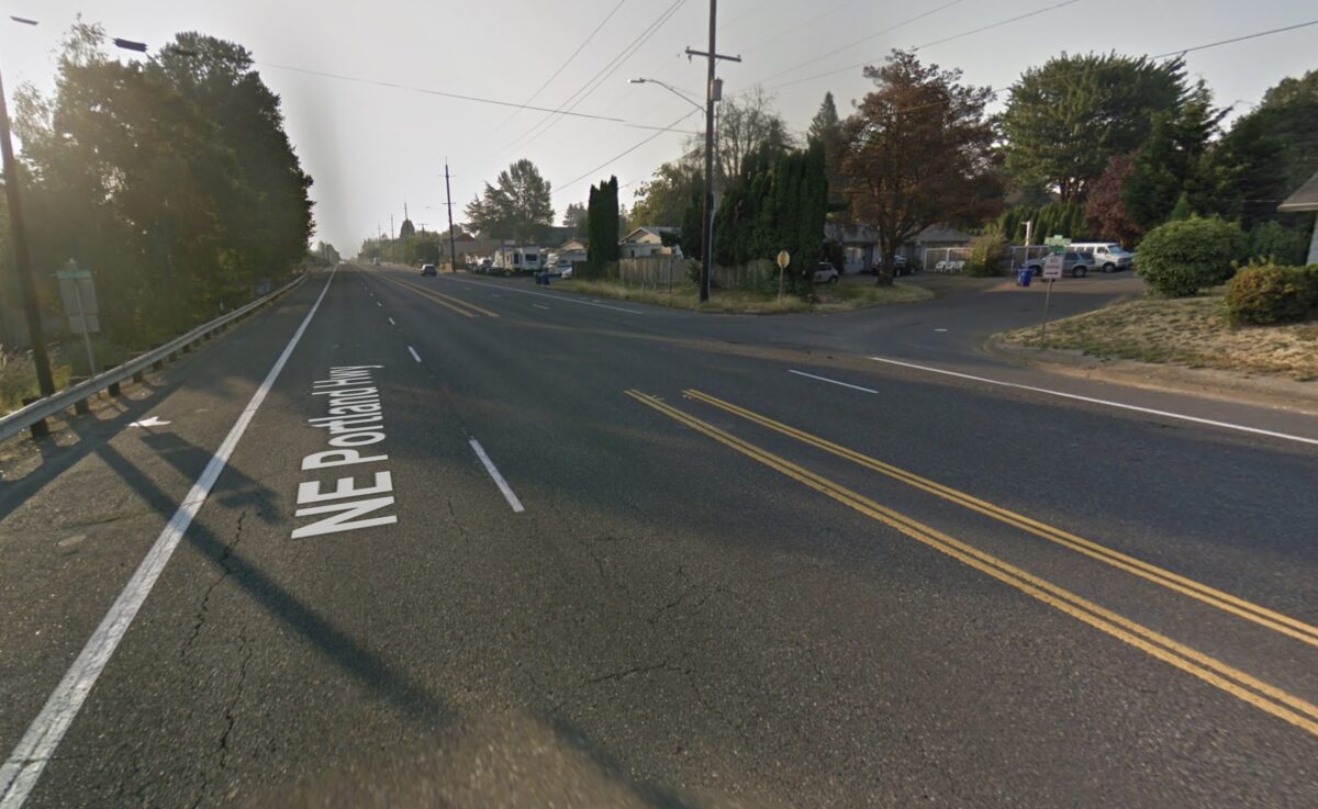
Sunday night around 8:00 pm someone who was walking in the Cully neighborhood near the intersection of Northeast 45th and Lombard died in a collision with someone driving a car. This is the third fatality in the Columbia/Lombard corridor in 2019 and it comes as the Portland Bureau of Transportation is working on a plan to improve conditions in the area.
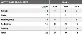
According to our Fatality Tracker this is the 39th fatality on Portland roads this year. Of the 39 deaths, 22 have been vulnerable road users (people walking, bicycling or using a moped/motorcycle). Since 2011, four people have died in the direct vicinity of last night’s collision.
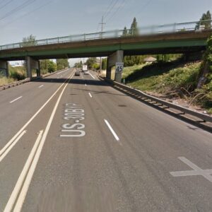
This section of Portland Boulevard (a.k.a. Lombard and US Highway 30 Bypass) is a very high-speed arterial, owned and maintained by the Oregon Department of Transportation, and listed on PBOT’s high crash network for it’s above-average crash rate. On KOIN-TV last night a man told news crews that, “You can go fast, you can go slow, you can do whatever you really want because there’s not really any police out here…” That comment comes just days after PBOT Commissioner Chloe Eudaly told the Willamette Week, “People are dying, and drivers are seeing people breaking the law, so why shouldn’t they? There’s no consequences.”
Advertisement
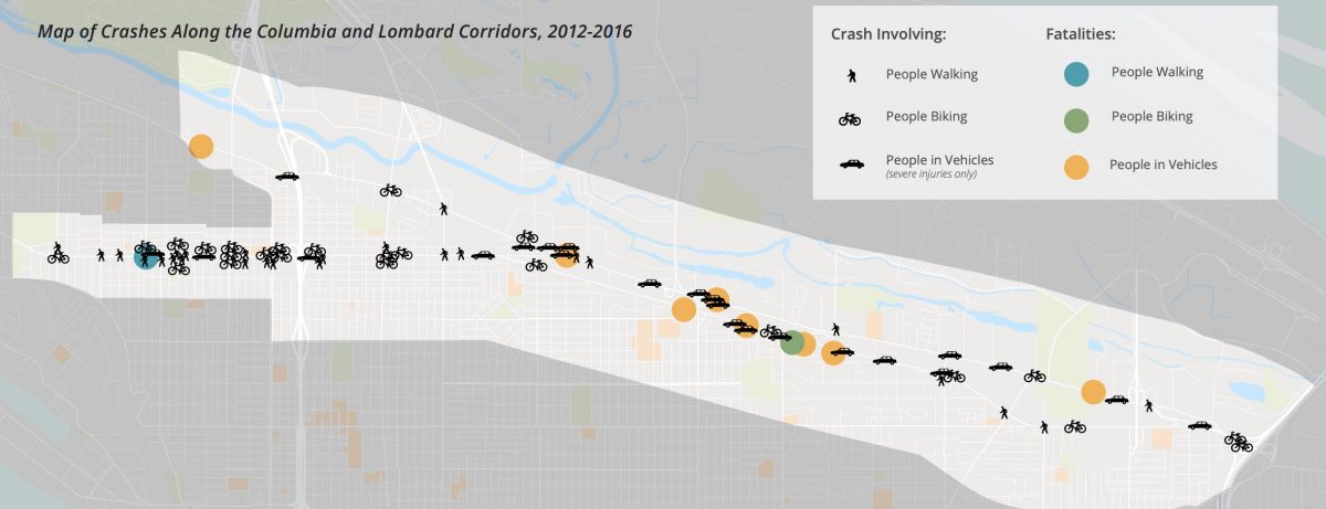
According to PBOT’s just-released Columbia Lombard Mobility Plan existing conditions report, 10 people died using this corridor between 2012 and 2016. Among the known issues outlined in the report are, “A lack of separation between modes, outdated roadway designs, and sub-standard infrastructure; the pedestrian, bicycle, and transit networks have major gaps and deficiencies; widely spaced and difficult connections across the corridor; and the street lacks adequate pedestrian facilities, crossings, and connections.”
Verde, a Cully-based nonprofit group that builds community through environmental initiatives, issued a statement about the crash:
We are saddened to learn about another pedestrian death in the Cully neighborhood last night, along NE Portland Hwy and 45th. We know Cully lacks safe pedestrian infrastructure: sidewalks, street lights, reduced speeds on high traffic corridors, etc. We will continue coming together as a community to advocate for transportation infrastructure that improves the safety of those who walk, bike and roll in our neighborhood.
We’ll update this post when we hear more from the PPB. If you have any information please call the non-emergency line at (503) 823-3333.
UPDATE, 1:45 pm: The PPB have updated their initial statement…
The Major Crash Team (MCT) has determined that the driver of the suspect vehicle left the scene of the crash, failing to perform the duties of a driver (hit and run). Police are still looking for the suspect and suspect vehicle.
Investigators are following up on leads and no description of the suspect vehicle is being released at this time. However, investigators are hoping to hear from anyone who has information about this crash and has not yet been contacted by police. Please contact the lead investigator Officer David Enz at 503-823-2208 or David.Enz@portlandoregon.gov and reference case number 19-319949.
UPDATE, 9/18 at 7:30 am:
The victim has been identified as 27-year-old Cristian Drae Lennon of Portland.
Officers are looking for a 1996-1998 red or maroon Chevy Blazer. This suspect vehicle should have front end damage.
— Jonathan Maus: (503) 706-8804, @jonathan_maus on Twitter and jonathan@bikeportland.org
Never miss a story. Sign-up for the daily BP Headlines email.
BikePortland needs your support.




Thanks for reading.
BikePortland has served this community with independent community journalism since 2005. We rely on subscriptions from readers like you to survive. Your financial support is vital in keeping this valuable resource alive and well.
Please subscribe today to strengthen and expand our work.
While this is the 3rd fatality of the year on the corridor, I think that even underestimates the actual danger here, because so many people like me have come to recognize how dangerous this area is and therefore no longer consider biking or walking along it. In my opinion the only folks who are biking or walking here are people who feel like they don’t have any other option, yet still we have seen 3 deaths this year. A massive change is needed to this infrastructure.
absolutely agree Bjorn. Lombard is such a huge opportunity to create a intra-neighborhood connected bike/walkway system. There’s so much extra space. We should narrow it, install physical protection with concrete barriers, reduce the space for driving, and watch how the area blossoms. Imagine being able to connect safely from Woodlawn to Cully on a simple and direct route. Add a few safe crossings of Lombard and you open up Columbia industrial area (ever tried to access Oregon Humane Society? Holy crap it sucks).
Or just a bus lane that runs from St. Johns to near cascade station/airport and take the rest of it down to 1 lane.
I live in Cully and Lombard would absolutely be the fastest way for me to get to North Portland/St Johns if it was a safe option. I used it to get home from working/racing at PIR until I got too spooked by the lack of safety infrastructure. Also, pretty much every night/weekend there are cars parked in the bike lane on both sides of the street.
I am with you Bjorn and find it fascinating that you also live on the other WORST Street for infrastructure in Cully… you know, the one we all use so frequently to get to the multi-million dollar park the city built but forgot to put ANY sidewalks to.
Supposedly only 2 more years before there will be a sidewalk to the park but yes I am still completely blown away that the city’s plan has been to make kids walk down a busy street with no sidewalks to get to a new park for years rather than building them at the same time.
“On KOIN-TV last night a man told news crews that, “You can go fast, you can go slow, you can do whatever you really want because there’s not really any police out here…””
In fact that now describes the entire city of Portland.
Why aren’t there any cops?
Because police enforcement strongly suggests racism, and because that is a delicate subject, PPB takes the opportunity to direct their funds elsewhere.
Speed triggered cameras don’t see race. they do see racing
The officer writing the citation while reviewing the picture does. But I agree, there does need to be enforcement, lawlessness clearly isnt working too well.
@mh, that could be part of the answer, but I’m pretty sure it’s not the whole answer. Part of the answer, I am convinced, is that Portland used to be a sleepy backwater, but now it’s mobbed by drivers with their cars. City services simply haven’t kept up, and one big reason for that is our commission style of gov’t. It’s not too going too far to say that Portland’s commission-style gov’t is killing us.
You know why.
🙁 just like to also point out NE 42 near alberta along with 47NE is becoming rather harsh riding a bike.. RIP
It would be nice to have a map like the one in the article for the entire city, and make sure it gets seen. Seeing the graphic symbols is less abstract than ones I’ve seen with little circles or numbers.
Interestingly transit is zero. How is that possible? A quick search pulled up an article of a Tri-met train colliding and killing a pedestrian in 2017. That doesn’t count I guess. How convenient.
I’m pretty sure that counts under “Pedestrian”. They are counting the number of people who died using each mode of transportation, not the number of people killed by each mode. A “Transit” death would be somebody killed in a collision while they were riding a bus or train.
So when you’re walking to get on the train, but that train ends up killing you it doesn’t count. Oh, okay! Thanks!
It counts as a death to a pedestrian, not as a death to a train rider. It makes sense.
So being killed while trying to board a train has nothing to do with the train. Wow, Trimet must love this rule!
If they were killed while actually boarding the train, then I agree, it should count as a transit death.
I choose lombard east to work and west home daily. Exciting for sure but Colubia is where its at if ya wanna really feel a rush!
Have you tried N Greeley? You get to cross an I-5 on ramp! It’s stupid!
As I rode by a ghost bike the other day, it struck me how quiet and sad it is. That is appropriate in many ways, but it does not draw attention to traffic fatalities. I would rather see a 10-foot by 10-foot skull painted in white retro-reflective road paint on the lane of each traffic death location regardless of mode.
The “Map of Crashes” states “crash involving” and has a symbol of a cyclist, pedestrian or car. The reality is that every–or virtually every–crash also involves a car or truck. I know that’s obvious, but it wouldn’t be a bad idea for the map legend to state that, to reinforce that fact.
People walking or biking don’t typically crash themselves, or even crash into each other. Motor vehicles are the only transportation mode that typically crashes into each other, or into inanimate objects. I’d like the map legend to add something like, “99% (or whatever) of crashes involving a cyclist or pedestrian involved a motor vehicle” as a reminder of that.
I just drove this today for the first time in a long time and it is terrifying. First, it’s a road in a city with a 45mph speed limit which is irresponsible. It also has “Slower traffic keep right” signs which have no business being within a city. These signs serve as a government statement declaring that speed is the priority and mandates that law-abiding drivers accommodate speeding drivers on a road with vulnerable users.
UPDATE, 9/18 at 7:30 am:
Cristian I am sorry your life ended that way.
The map is important because it shows that this piece of road is dangerous and we ALL knew it before this person died. Brave hardy people stay away…the map has a problem though in that it looks like bikes are crashing, crashing. Yes I read the tiny-type disclaimer. It should say in bigger type ‘we couldn’t put all the car crashes on here because there were so dang many’.
The map does show that this road is even more deadly, in raw numbers, for people in cars than for others. ODOCars is letting their constituency down.