After kicking off about a year ago, the Portland Bureau of Transportation has released a major piece of their Northwest in Motion Plan (NWIM).
As we reported back in November, the goal of this plan is to create a detailed and prioritized list of shovel-ready projects that can be built in the short-term (1-5 years). PBOT’s work in northwest mirrors the East Portland in Motion and Southwest in Motion plans (we’ll likely see similar efforts in southeast and north/northeast soon).
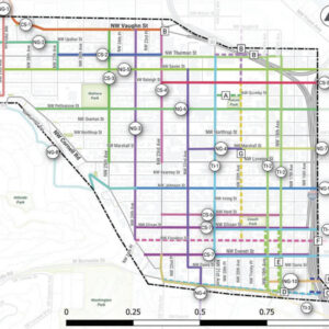
The Draft Tier 1 Projects Overview (PDF) includes 12 projects broken down into three categories: neighborhood greenways; transit improvements, and corridor safety.
Similar to recent work we’ve seen from PBOT on NE 7th and in southwest, the designs in this plan push the envelope for active transportation. Staying true to our myriad lofty planning goals, the Northwest in Motion proposals put walking, biking, and transit firmly atop the modal hierarchy. With a variety of traffic calming measure, right-of-way adjustments, and lane reconfigurations, PBOT is showing us the potential of our streets when we don’t make driving the top priority.
Below is a look at a few of the nuggets in the draft project list:
Beefing up NW Johnson with major changes near REI
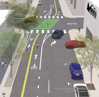
The plan calls for updated the existing greenway on Johnson between 9th and 25th. This is a crucial east-west biking corridor that connects the Broadway Bridge to the west hills and provides access to many high-value destinations.
PBOT wants to make it better for biking by removing old train rails at 15th, installing significant traffic diverters to lower driving volumes, adding speed bumps, turning stop signs to improve cycling efficiency, adding crossing upgrades, and smoothing out broken pavement.
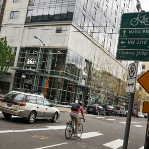
The section between 14th and 16th (REI) is the most stressful today. PBOT wants to make it better by turning NW Johnson into a one-way for drivers and adding a separated, two-way bikeway through the entire section. To get the space, they’d remove an existing lane used for on-street parking. New diverters would prevent cut-through drivers.
Advertisement
Separated bike lane on Overton at Fields Park
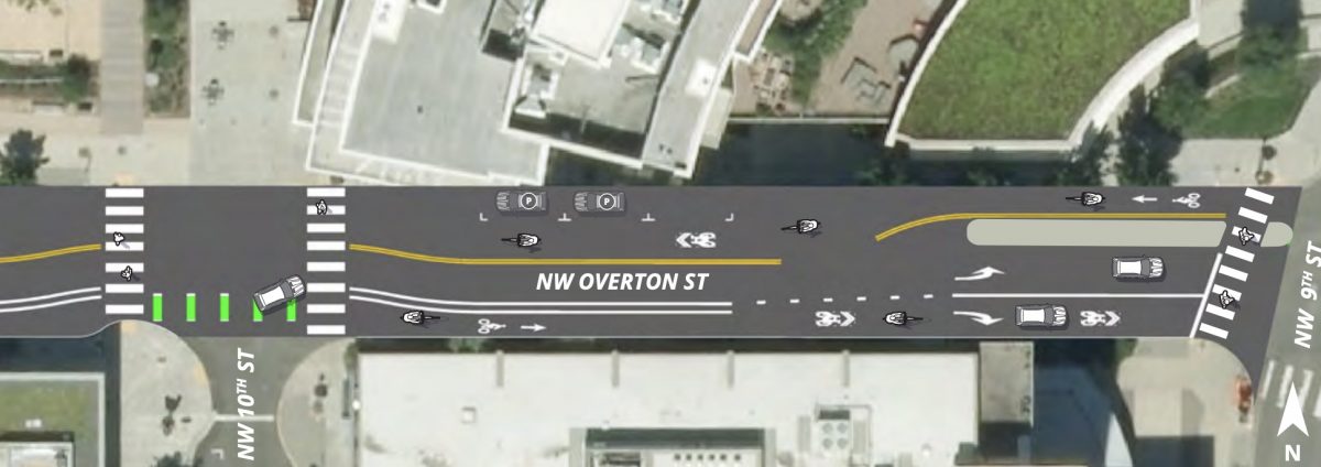
Overton provides a nice connection to NW Naito Parkway, Fields Park, and more. Currently it has no dedicated cycling space and people parked their cars on both sides of the street. PBOT’s plan would provide a buffered bike lane eastbound (using space currently used as auto parking) while maintaining a shared lane westbound. To reduce the amount of drivers on the street, PBOT would install a full diverter at NW 9th
Serious diversion on Marshall
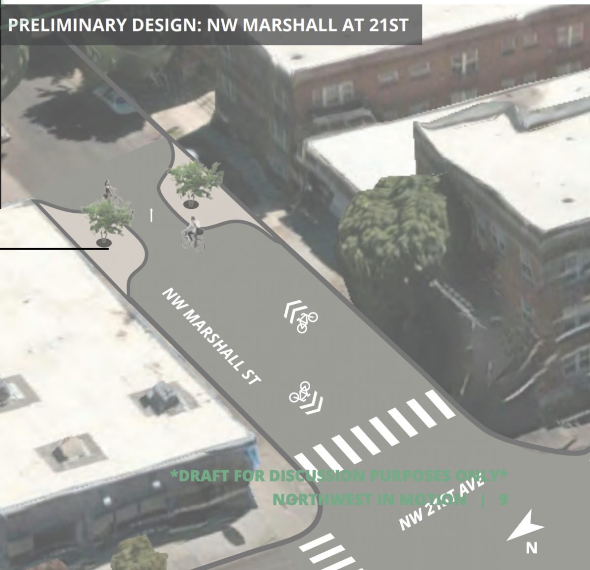
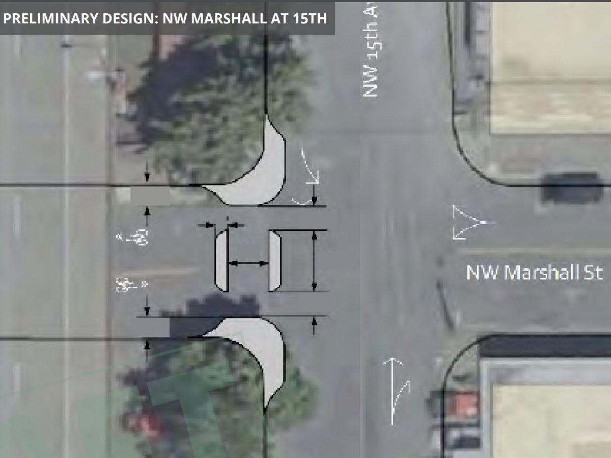
The proposal should significantly reduce the amount of drivers on NW Marshall. A full diverter at 15th (under I-405) would prevent through auto traffic and a neckdown between 20th and 21st would limit cut-through drivers.
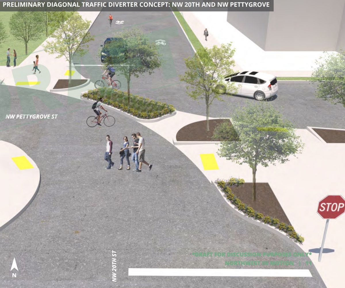
Diagonal diverter at 20th and Pettygrove
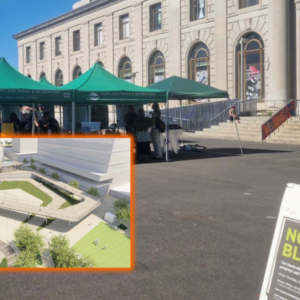
A thing of beauty isn’t it? PBOT wants to do this to reduce driving traffic at the confluence of two neighborhood greenways and create new green/public space.
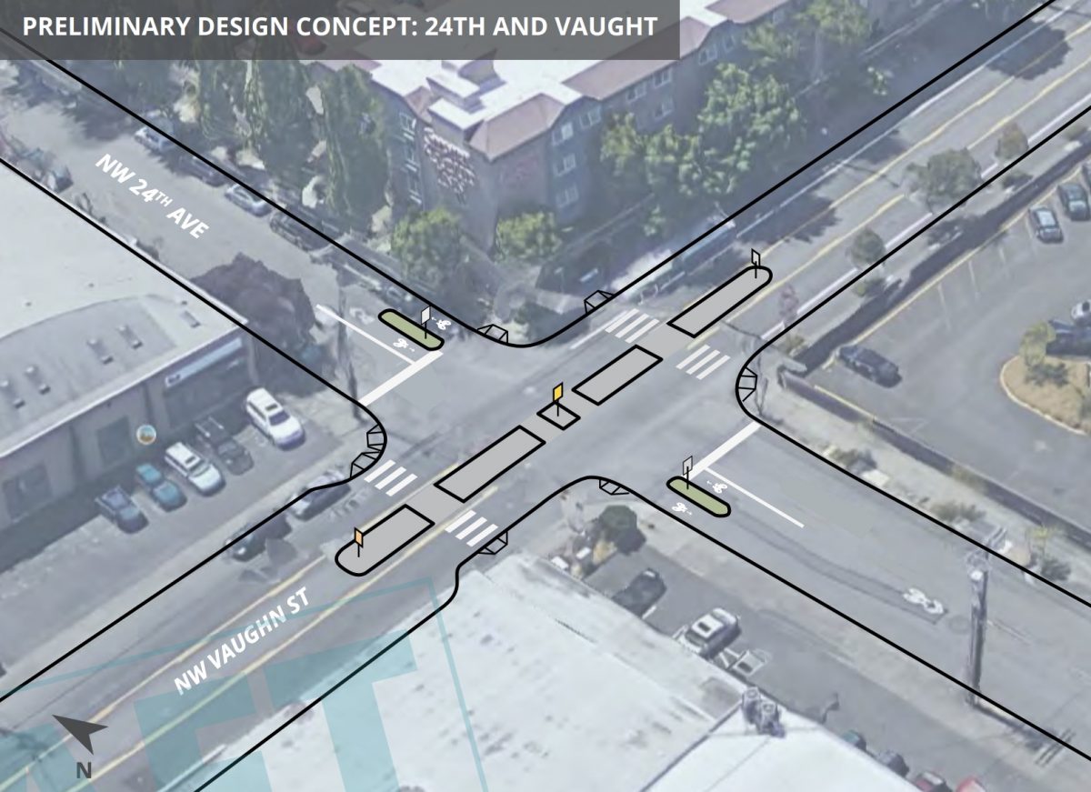
As the westernmost through street at the base of the west hills, 24th is a key connector to the Lovejoy-Cornell corridor, commercial district on NW Thurman, Highway 30, and much more. I’m most excited about the treatments proposed at NW Vaughn, an industrial collector that is very stressful to cross and ride on. PBOT wants to restrict turning movements from Vaughn onto 24th with a full median and make the crossing safer.
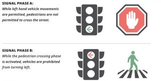
The existing bike lanes on Vaughn would also be improved. PBOT wants to beef up striping through intersections and install “protected left signal phases” at 25th and 27th. These would separate the biking/walking movements from the driving movements so that dangerous left-turns would no longer be a source of collisions.
New transit islands could be coming on Marshall and Flanders at 18th and 19th. PBOT’s design have the bikeway go behind the bus stop. Bus operators would save time and have less conflict with bicycle users by stopping in the travel lane instead of right next to the curb. I’ve been pushing for this design for years and would love to see it used citywide.
While these designs look promising, northwest neighborhood resident and NWIM Community Advisory Group member Reza Farhoodi said advocacy will be needed to make them a reality. “I think the draft plan overall does a great job of shifting the Overton window on bicycling and safe streets in northwest, but it’s not a done deal,” he shared with us via email today. “Effective outreach is critical for engaging people who want to see real improvements to bicycle facilities in northwest and help advocate for this plan at City Council.”
What do you think about these designs? Stay tuned for announcement of dates for open houses next month.
And keep in mind, this isn’t everything PBOT is planning for northwest. The Flanders Crossing bridge and Flanders Bikeway are both slated for construction next year. Portland Streetcar is also planning a major northwest expansion that will come with additions and changes to the bike network. Stay tuned for more on that project.
— Jonathan Maus: (503) 706-8804, @jonathan_maus on Twitter and jonathan@bikeportland.org
Never miss a story. Sign-up for the daily BP Headlines email.
BikePortland needs your support.



Thanks for reading.
BikePortland has served this community with independent community journalism since 2005. We rely on subscriptions from readers like you to survive. Your financial support is vital in keeping this valuable resource alive and well.
Please subscribe today to strengthen and expand our work.
The car in the lower left-hand side mows over the pedestrian in the crosswalk then shifts in to reverse down the bikeway to their parking spot.
I was seeing the same thing. They’d have to take a U-Turn in the center of the street to get to those spots.
Although, there is a parking garage on Overton just before those parking spaces…so, maybe they’re for the people who drive from the parking garage to get coffee at Ovation:
https://www.google.com/maps/@45.5322767,-122.6808982,3a,75y,308.48h,73.6t/data=!3m6!1e1!3m4!1sO0hQDpf6aAbDRM-ics4TYw!2e0!7i13312!8i6656
That’s sure a nice greenspace diverter at 20th and Pettygrove, but I thought this is what Platinum looks like based on the Rodney Greenway Diverters at Ivy.
https://www.google.com/maps/@45.5476544,-122.6640983,3a,75y,168.15h,74.58t/data=!3m6!1e1!3m4!1smLzmUutsyVdiXT9-Qn2bJg!2e0!7i13312!8i6656
The centerpiece of NWIM should be district-wide traffic calming. People are less likely to use these terrific location-specific improvements without that.
The only legal way would be to enter the parking garage there, drive back out, make a right, and park. In reality, it seems like a 3-point U-turn in heavy traffic would be more likely.
So, recently, the City added some stop signs on Overton, making it impractical as a bikeway. From my job at Thurman and 16th I take Front to 9th, then Broadway bridge now because both Marshall and Overton are so unpleasant. Are they planning on re-configuring the stop signs on Overton again? Overall, exciting changes!
Overton has turned into too way much of a car thoroughfare between 9th and the greater NW area. Over the years the stop signs have come and gone. For awhile there was a 4-way stop at 11th & Overton, visible in Nov. 2015 Street view. That oddly went away, and only recently has a stop on Overton been added at 13th. I think the diverter stopping traffic @ 9th would help a lot, but you’ll still have plenty of cars driving Overton to 9th. And then it’ll still all jam up when a freight train pulls through.
The plan is proposing to shift the greenway to Pettygrove to take advantage of the Green Street design that includes wider sidewalks, landscaping and no garage entrances in the Pearl. This route would be a straight shot to the new community space in Slabtown, Wallace Park and Chapman Elementary. However, a connection is still needed between 9th-11th because Pettygrove ends at Fields Park.
There are numerous problems with Overton that have led to the proposal shown here. First, traffic volumes exceeded 3,600 vehicles per day in a recent PBOT count. So it’s a major cut through route, but traffic calming options are limited because it’s also an Emergency Response route for the Fire Bureau. That means that until recently, there were no options to slow down the dangerously fast car traffic on this stretch (9th-14th). It’s a major pedestrian safety concern with all the multi-family residential and Fields Park nearby. PBOT recently got approval to install the two new stop signs, which may be annoying to cyclists, but it was intended as a first step before moving the greenway to Pettygrove. This will allow PBOT to install more aggressive traffic calming (and turn stop signs) in a way that they wouldn’t be able to do on Overton.
The design shown between 9th and 11th is intended as a compromise. Because of the one-way nature of streets in the area and the presence of Marshall which is also a neighborhood greenway, PBOT needs to maintain access for automobiles and emergency vehicles heading eastbound to get to 9th and Naito. Therefore, bikes would get a separated bicycle lane heading eastbound and parking would be removed. Approaching 9th, the bike lane would become a right turn lane, allowing for all modes to turn right when a train is blocking the nearby crossing.
Meanwhile, a diverter at 9th heading westbound would reduce volumes substantially, and allow for a more comfortable shared street environment in that direction before transitioning to Pettygrove. PBOT thinks they can get Fire Bureau approval for this diverter because ostensibly it’s only an emergency to head east TOWARDS a fire, not heading back west to the station (at 17th and Johnson). We’ll see if can be implemented as shown here or whether additional tweaks are needed.
I don’t understand that last one. Pedestrians will have to walk across the bike lane to get on/off the bus, and might be blocked from the cyclist’s line of sight by the parked bus. Sounds like it will increase the odds of accidents where the cyclist is a fault.
It’s a pretty standard design. Buses don’t “park” there, they load and unload at the bus stop there. If your line of sight is “blocked” by the bus it’s pretty safe to think that there may be people using the bus stop, and you adjust your speed accordingly.
Although in practice – and I use lanes like this daily, passing dozens of bus stops – the majority of the time there is no bus there. When there is a bus there the people exiting the bus are rarely crossing the bike lane when I’m at the crossing point. When they are there, it requires a minor slow down. I probably have to come to a complete stop – typically for a person with impaired mobility – around five times a year. I do not consider these factors to be a problem with the design.
Here’s a video on Cycle Superhighway 2 in London (https://youtu.be/6pmRHX7iKJQ?t=428). It’s not my video, but I’ve ridden the route. It’s far from perfect, but also far better than anything that’s been built or planned in Portland to date.
At about 7:10 a bus overtakes the cyclists on in the bike lane, and pull up to a stop at 7:24. Someone was already waiting in the island to board the bus, so there was no conflict between the bus riders and the bike riders. The bike rider didn’t have to come to a stop (as is sadly planned for the stations on the Division Transit Project).
The floating bus stops are a huge improvement over our current practice of having buses pull into a bike lane.
That’s also what I thought but it’s just that the picture isn’t very good. There’s a platform next to the bike lane that is wide enough that an approaching cyclist can see through it at all the passengers boarding and exiting the bus to the left of the platform.
Seems like it should be reversed, with parking spots for eastbound cars next to the standard lane, and westbound bike traffic running between parked cars and curb on the north side.
NW Johnson Improvements will be nice, but I tend to avoid as it is out of the way for my commute. For a greenway you hit a LOT of stop signs, otherwise I would ride. Can’t wait for Flanders to be built out.
stop signs are removed or turned for greenway projects.
My direct route to the west would be riding up Glisan, but I go 6 blocks out of my way to ride Johnson instead. It’s better, but I still have to deal with some dorks in cars who don’t know that Johnson is a greenway, and an abundance of stop signs. I’m looking forward to these improvements!
Wth the RIDICULOUS amounts of vehicle traffic now on the NW Raleigh BIKE STREET since New Seasons opened and they stuck a freaking TRAFFIC LIGHT at 21st, meaning the car traffic now has unimpeded access west to Chapman Elementary, this two-way cycleway on Savier should have happened THREE YEARS AGO.
Seriously, what the hell.
The rest of the story is some of the older ‘greenways’ are being retired.
Well, that’s fair enough, but they shouldn’t retire the old stuff before the new stuff is in fricking place.
I’m tired of seeing an endless array of over-produced over-engineered plans from PBOT that are all about “how we can spend money we don’t have to pour concrete.” That doesn’t get us a bike network. Endless process and endless planning means there’s only ever funding for what seems to be about 5%-10% of the plans we see, always based on way more concrete than we need.
I’d rather see a bike network built NOW, using what we’ve got. Is Better Naito perfect? Nope, but it’s out there and people are using it right now. PBOT has plastic jersey barricades, bollards, and other TCD’s like rubber barrels full of water galore. Set them up and give us some protected bike lanes and protected pedestrian crossings now. Not in 3 to 30 years.
Every one of these designs with a concrete “refuge” or other type of “bulb out” transforms a $10,000 stripe and relabel project into a $70,000 – $250,000 budget eating debacle. And by the time we finally get it in 5-10 years, we’re getting an antiquated system.
I wish PBOT would quit wasting our time, get real, and show us what can we afford to build now. I’d rather have a usable bike network as soon as possible. Can we at least set up some orange cones on sand-bags, while they take their pretty project proposals to enter at the planners conference?
Temporarily set up as much as they can now. Quit the concrete crap. Nothing proves concept like letting us use it.
paint, barrels, wands protect no one, ever.
Some attention on 24th is good. Traffic gets busy there. 24th and 25th are often recommended by driving apps for routes between Hwy 26 and I-5 north, via Cornell, Vaughn, and 405 when freeway traffic’s super bad. Modifying 24th and 25th so driving apps don’t prioritize it may redistribute a fair amount of late-for-work commuters following Waze directions to more appropriate routes.
It feels like these projects are picking around the edges. It would be nice to see serious improvement dig into the middle of the NW area. Getting into the south end of NW is kind of awkward, for example. The Everett treatment has made leaving lower NW really easy, and I’ve noticed that a single car lane has been more than adequate. Traffic volumes on Glisan are significantly lower than on Everett. Imagine Glisan, Everett-ized, with proper bike facilities going up the hill through lower NW. I for one would use the heck out of it.
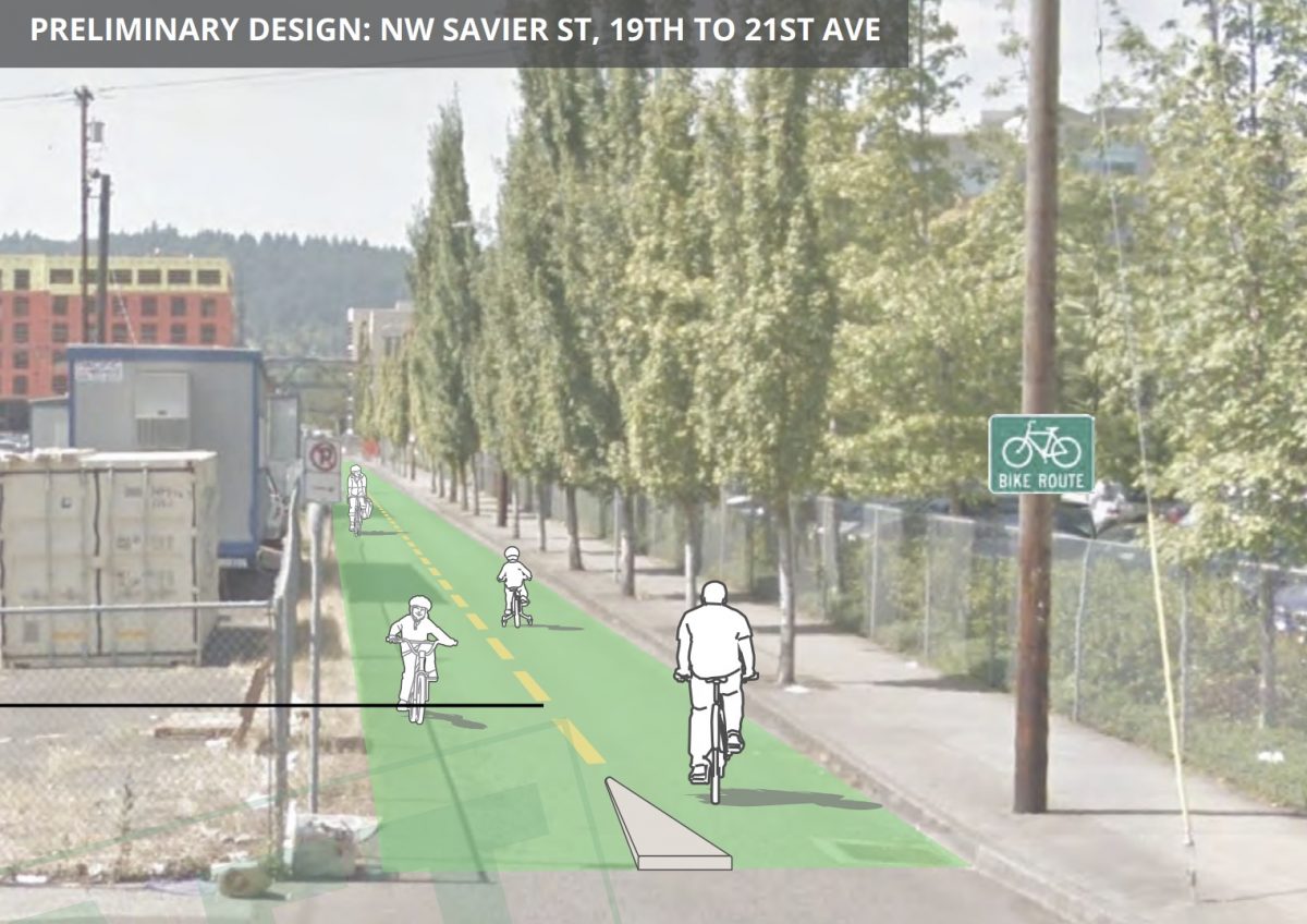
That first image looks odd to me. Green paint is meant to indicate a bikeway crossing a general lane. It isn’t needed on a dedicated off-road bike path because the people there already know that’s where they are.
It’s good otherwise.
The second image with the diagonal crossing needs some some diverters to limit motor vehicle turns. Here’s an example:
24th and Vaught looks good.
My initial response, as a daily cyclist who lives in NW Portland, was – ‘great! progress! At last some steps to make riding here less dangerous.’ Thank you to those who pointed out the shortcomings of the plans and how much more needs to be done.
As a first step, how about if several East-West and North-South streets in NW Portland are closed to all car traffic? Savier? Hoyt? 20th? 24th? These are the immediate streets next to the car-heavy Thurman, Glisan, 21st and 23rd.
In the meantime, we can also follow in the footsteps of Cambridge, Mass. where the city council just voted that protected cycling lanes be installed on all streets slated for reconstruction.
As reported by CityLab, “the measure, the first of its kind in the U.S., requires the city to erect vertical barriers between cyclists and cars on any roadway that’s rebuilt, expanded, or reconfigured if it’s part of the proposed 20-mile network of separated lanes known as the Cambridge Bicycle Plan. Only in “rare circumstances” where the city manager must cite physical or financial restraints will there be exceptions. By passing a law that mandates bike protections, rather than administering a policy that merely calls for them, the city has created politically strategic armor to shield its transportation objectives from detractors. the whims of future elected leaders who might not share its vision. And, when business owners and residents try to hold back new cycling infrastructure, officials can override them by pointing to the law.”
By eliminating the heavily used left turn from Vaughn onto 24th, this means cars will either have to turn on increasingly crowded 23rd, or go to 25th and turn left- going out of their way, adding more carbon to the atmosphere. PBOT also proposes putting a “diverter” at 24th/Flanders/Westover, will be forcing cars- that would otherwise go onto 24th- onto Westover and 25th- again driving further than necessary.
Combined with what PBOT proposes at Vaughn, this would add a huge amount of vehicle traffic onto 25th in both directions- creating more air pollution than necessary.
PBOT needs to balance what may be good for bicyclists with common sense, as well as what is good for those who live in the neighborhood.