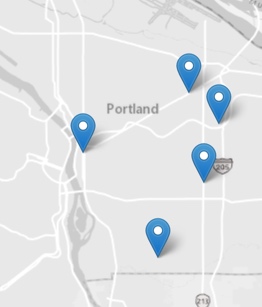
(Graphic: Metro)
On Thursday the Metro Council unanimously adopted $30 million in grants for 12 transportation projects around the region. Portland won big by garnering $12.8 million of the total awarded. The funds will go toward five different projects — four of which ($10 million worth) are focused specifically on making it easier and safer to bike and walk.
Yesterday’s decision comes after a year of public feedback and analysis of dozens of projects that vied for the money. It’s part of Metro’s regional flexible funding process that happens every three years. Out of this pot of around $130 million, $33 was up for grabs in a suballocation that Metro decided to split 75/25 between “active transportation/complete streets” projects and freight projects respectively.
Although one of Portland’s projects was in the freight category, it also includes several elements that will improve biking and overall traffic safety.
Here are more details on the five projects (taken from PBOT project applications):
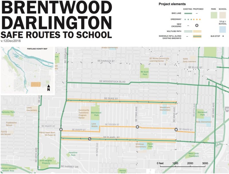
Brentwood-Darlington Safe Routes to School – $2.2 million ($6.6 total project cost)
PBOT says the Brentwood-Darlington neighborhood has numerous sidewalk gaps and “substandard” bicycle facilities. This project will remedy that by building sidewalks on SE Duke and Flavel from 52nd to 82nd. It will also create a neighborhood greenway on SE Knapp and Ogden from 32nd 52nd to 87th. Of particular note is a major crossing upgrade of SE 82nd between Ogden and Knapp. PBOT will construct a multi-use path on the west side of 82nd. Also at Knapp/82nd, a traffic island will be placed in the center turn lane and there will be a rapid-flashing beacon. At the crossing of SE 52nd and Knapp there will be new curb extensions at the NW and SE corners and island-protected bike lanes at the NE and SW corners. (Note: This project was originally conceived with a multi-use path connecting 87th/Flavel to the Springwater Corridor. PBOT is working with Portland Parks to reinstate that element. The scope was changed prior to the final grant award decision.)
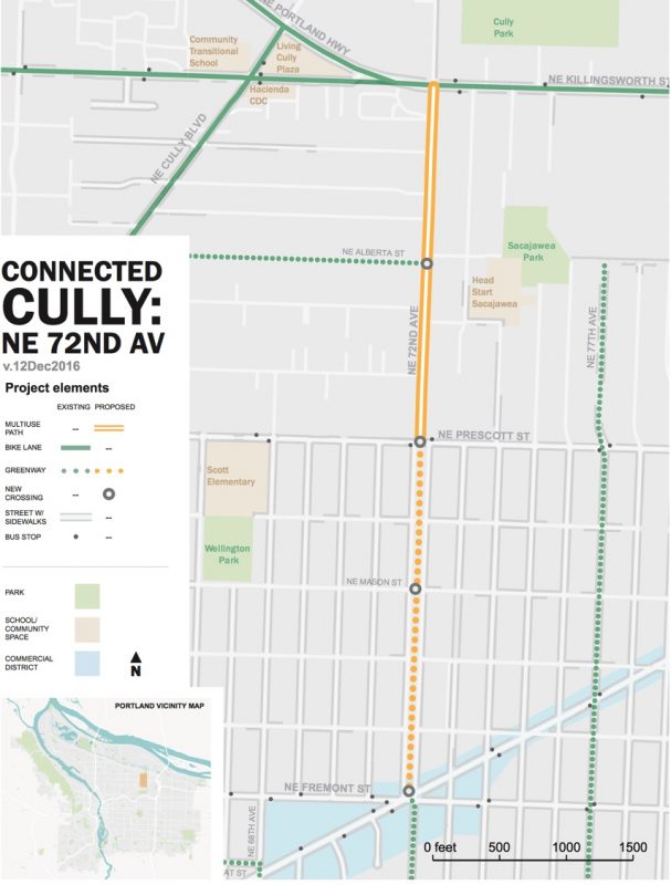
Cully Walking and Biking Parkway – $2.2 million ($5.9 million total project cost)
Several blocks east of the City’s first-ever cycle track on NE Cully Blvd, this project will build a new bikeway on one mile of NE 72nd “through the heart of the Cully neighborhood.” Here’s more from PBOT’s application: “It will help to break down historical barriers in the form of freeways and busy streets and create a major network connection that serves multiple neighborhoods that have been traditionally left out of active transportation infrastructure investments.” We can expect new sidewalks and crossing treatments the length of the corridor. On the bicycling side, this project will build a separated multi-use path parallel to the roadway from Killingsworth to Prescott. The middle section from Prescott to Sumner has sufficient right-of-way to construct separate pedestrian and bicycle facilities, so that section will feature a two-way raised bikeway with a 4-foot planting strip as a buffer from the roadway. South of Prescott (to Sandy) PBOT will use a neighborhood greenway treatment. (The project was initially concieved with a path the entire length, but the scope was changed prior to the grant award.) The project will also include new lighting, street trees and “place-making elements.”
Advertisement
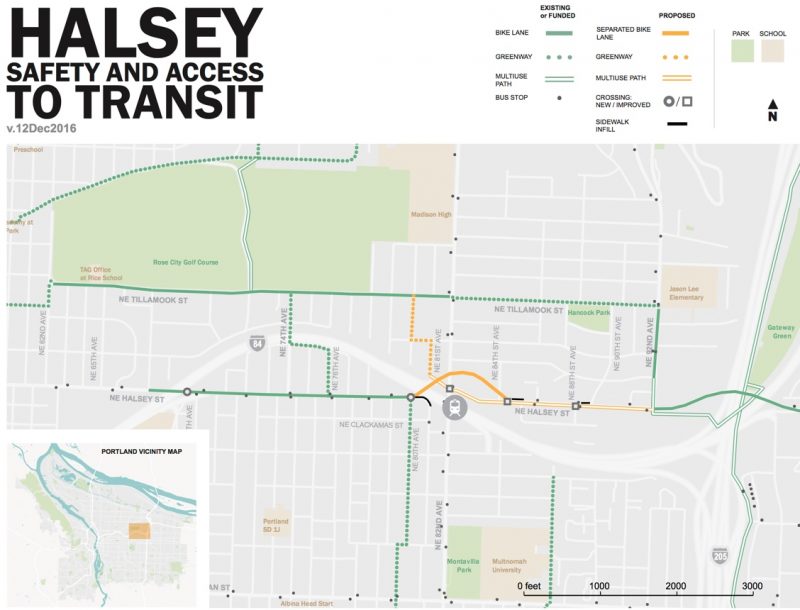
Halsey Street Safety and Access to Transit – $2.4 million ($5.1 million total project cost)
The idea behind this project is to improve access to the very busy 82nd Ave MAX station and bus stops and improve safety along NE Halsey. On the Halsey overpass of I-84 PBOT will build a two-way protected bike lane and between 82nd and 92nd they’ll build a new 12-foot wide path separated by a planted buffer on the south side of Halsey (that will ultimately connect to the forthcoming undercrossing of the I-205 path at Gateway Green which is part of the Sullivan’s Gulch project). PBOT says the project will, “provide a dramatically improved user experience.”
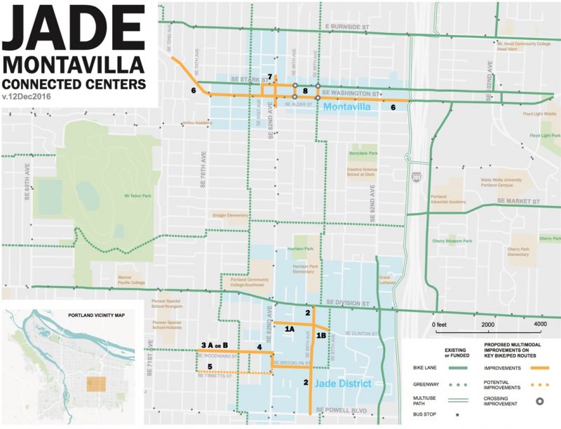
Jade District and Montavilla Connected Centers – $3.2 million ($7.8 million total project cost)
This project includes eight key pieces of new infrastructure that will make biking and walking in the Jade District and in the Montavilla commercial district easier and safer. Highlights include a separated and protected bike lane on SE Washington from 72nd to I-205 that will include a 16-inch wide raised curb between the standard vehicle lane and the bike lane. To get the space for this PBOT will remove on-street auto parking on one side of the street. West of 76th, on a curved section where Washington becomes Thorburn, the new bike/walk path will replace an existing standard vehicle lane and be separated from other traffic by a jersey barrier (PBOT says this lane space reallocation can be done, “without significant traffic impact.”) In the Jade District, PBOT will improve several arterial crossings as well as add traffic calming and bikeway upgrades on SE 85th.
From PBOT:
Project Elements (numbers refer to map):
1. Street, sidewalk and lighting on SE Clinton between 82nd Ave and 87th Ave.
2. Sidewalks on portions of SE 85th between Powell and Division to fill gaps of missing sidewalk. Add lighting at Division. Minor improvements to the 80’s Neighborhood Greenway on SE 85th Ave between Division and Powell to address segments exceeding recommended volumes or speed per the 2015 PBOT Neighborhood Greenway Guidelines.
3. (3 and 4, or 5) SE Woodward Neighborhood Greenway improvements from approximately 75th/78th to 85th Ave. Either improve the route along SE Tibbetts to SE Brooklyn (5) or SE Woodward to SE Brooklyn (3 and 4). Either includes a jog on 82nd Ave for roughly half a block with a two-way bike path combined with the sidewalk behind existing curb. Enhanced crossings of arterials, locations to be determined.
6. Add Separated Bike Lane with physical protection on SE Washington from 72nd to 92nd Ave/ I-205 multi-use path.
7. Reconfigure left turn movements from 82nd to the Stark/Washington couplet to reduce neighborhood cut-through traffic impacts on local streets.
8. Enhanced crossings of arterials, including SE Washington and Stark at 84th and 86th.
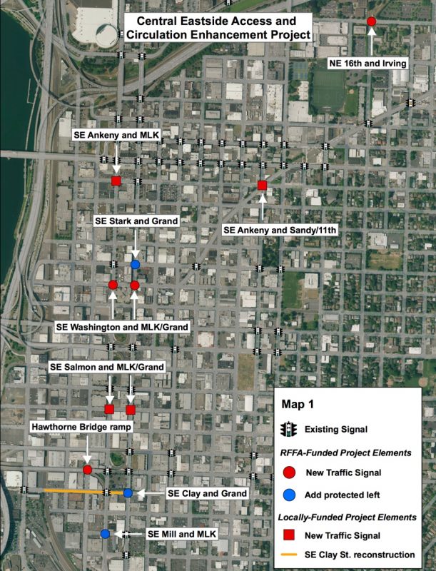
Central Eastside Access and Circulation Improvements – $2.8 million ($5.4 million total project cost)
While funded in the freight category, this project will also improve cycling on the central eastside. Of particular note is the repaving of SE Clay (a major east-west bike route to the Esplanade and Hawthorne Bridge) and a new traffic signal on Ankeny (a popular bike route) at the tricky intersection of SE 11th/Sandy. Here’s more from PBOT:
The project will improve freight access and circulation and reduce conflicts in the Central Eastside by adding new traffic signals and beacons, and modifying existing traffic signals, consistent with the adopted SE Quadrant Plan. New traffic signals will be added at 16th/Irving (serving the freeway ramp entrance), Ankeny/MLK, Ankeny/11th, Washington/Grand, Washington/MLK, and the Hawthorne ramp to MLK/Clay. Pedestrian hybrid beacons will be added at Salmon/Grand and Salmon/MLK. Signals will be modified to allow protected left turns from Stark to Grand, Washington to MLK, Clay to Grand, and Mill to MLK. The project also includes roadway reconstruction on SE Clay St from Water to Grand to improve freight operations.
This is a very exciting slate of projects and PBOT deserves major kudos for getting them all lined up. The focus on east Portland and areas with major safety and access needs means these projects just might entice a new segment of our population out onto the streets.
With local (city) funding through a mix of system development charges, gas tax money, and general transportation revenue, all of these projects are now fully funded. Keep in mind though, that the Metro (federal) portion won’t get paid out until 2019, although it’s possible construction could begin prior to that date. Stay tuned for more information on each project as they get closer to breaking ground.
— Jonathan Maus: (503) 706-8804, @jonathan_maus on Twitter and jonathan@bikeportland.org
BikePortland is supported by the community (that means you!). Please become a subscriber or make a donation today.




Thanks for reading.
BikePortland has served this community with independent community journalism since 2005. We rely on subscriptions from readers like you to survive. Your financial support is vital in keeping this valuable resource alive and well.
Please subscribe today to strengthen and expand our work.
What does “will use a greenway treatment” mean within the context of the 72nd avenue improvements. 72nd from Prescott to Fremont consists of 2 narrow one way streets with parking on either side of a series of park blocks. I had previously heard that a path would be built through the park blocks so that cyclists didn’t try to have to contend with people using 72nd as a cut through. “Greenway treatment” has me concerned that this won’t be the case and that cyclists will still have to contend with impatient drivers who want to pass when there is often not enough room. Perhaps some of this could be mitigated with a diverter to try and discourage through traffic from using 72nd.
I actually think one solution that would also dramatically improve the intersection at sandy/fremont/72nd would be to cease to allow cars to access sandy/fremont from 72nd, and vice versa. This would take what is currently a 6 way intersection and reduce it back down to 4 way for cars, which would be safer and also reduce waiting at the signals.
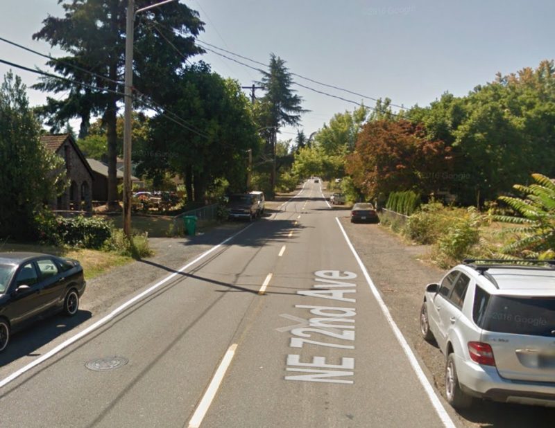
Link to what one side of the street looks like. I know people who are too scared to ride up it because of interactions with car drivers who want to zoom through and are unwilling to wait for a safe place to pass:
https://t.co/Grwng0brcK
It’s a tricky environment, but with some speed bumps and diversion and perhaps targeted parking removal to create “passing zones” it could work. The path through the median was strongly opposed by neighbors who pointed out they have used it as their neighborhood park for decades.
ooh “passing zones” by way of parking removal? That sounds really interesting Beeblebrox. Would love to know more once the design firms up. Perhaps it’s time to employ some of the lessons from Rotterdam and create deliberate “cars as guests” zone? https://bikeportland.org/2013/06/06/in-rotterdam-a-peak-at-dutch-road-design-in-an-american-style-city-87873
Strongly opposed by a small number of neighbors, strongly supported by others including me. The parkway is wide, a pathway on one edge or the other would have been a great improvement. Sharrows are not going to fix the problem here.
It would be interesting to see if it was presented as a choice between removing parking on 72nd or building the path which people would choose. My money is on a sudden shift of support for the path.
There’s no reason both options couldn’t be presented to the community…but more funding would be needed to build the path option.
Why take green space away from everyone to maintain a parking lane that doesn’t get heavily used? Plenty of people have driveways and don’t need more room for their cars.
If someone on the block values parking more than green space, then let them remove the grass strip between the sidewalk and the street to put in an extra parking bay for themselves. Make sure it comes with a high curb to keep them from parking on the sidewalk and charge a fee based on the value of the tree removed (if any) to fund improvements on the central parkway.
When you go to a park and there is a path that goes through it doesn’t it just feel like a normal park? I don’t see how a path is so incompatible with a greenspace.
Ughhh…the word “treatment”. What, bikes are a disease? Cars are the disease.
bumps, diversion, sharrows.
Wholesale parking removal would be very difficult along 72nd, but creating some spaces for comfortable passing seems like it has potential, especially by pulling back parking from corners. As you example illustrates, there’s also signage and design that just makes it clear that drivers need to slow down and just forget about passing. It will be an interesting public process to get a design figured out.
The bulk of the drivers who are the problem don’t live in the neighborhood and don’t care. They are looking for the fastest way through and have found that cutting up 72nd is faster than using the arterials at 82nd or cully. I really think there are only 2 options for making riding up that hill something that feels safe to most people, and those are a separated path, which there is plenty of room for, or preventing cut through traffic which is more difficult as much of that traffic would likely move over to 71st which is also not ideal. The median strip there feels like a park, but it isn’t, it is under PBOT’s domain. The thing is like 90 feet wide, using 10-12 feet of that for a path that would be a huge improvement for safety seems like a very minor change, especially when you consider that there are actually several good sized actual parks located around a quarter mile from this narrow median strip. Killing this path is a classic NIMBY problem no different from what we see in Forest Park where neighbors who live across the street from the median have over time come to see it as a part of their property that they should be completely in control of rather than what it actually is, a piece of public property managed by the Bureau of Transportation.
Those who live in this Roseway neighborhood have spoken already. No path down the middle of the parkway. Regarding taking parking away. Sick of J. Maus like thinking of making this city Rotterdam. Just go away.
These all look like good projects. I like that PBOT is pushing curb-separated cycleways, not just the mountable curb ones. The Ankeny/Sandy intersection is currently terrifying; glad it’s getting a signal. As is the Woodward greenway 82nd Av crossing; no more having to ride on the sidewalk!
Although I am not thrilled with PBOT’s decision to put the protected bike lane on Washington rather than Stark in Montavilla. Huge missed opportunity to have good cycling infra though a commercial strip.
Most federal funding grants give preference to new facilities over enhancements to existing facilities. Washington does not currently have any bike lane at all, whereas Stark does have a bike lane (just not protected).
My hood. Many neighbors preferred adding something to Washington since there is no facility at all. While not grand, Stark has a bike lane and the main businesses there with people helps slow traffic, somewhat.
In contrast, Washington’s current design has people driving going extremely fast to get from the SE 76th light to the 82nd light.
That makes sense. Washington is pretty wide and a protected cycleway would definitely improve things. Just would be nice to have a protected bike lane to accesses businesses rather than simply being a commuting route.
Nothing for east Portland. Nice to see a bike / walk bridge over I5 in Wilsonville and a new industrial jobs opportunity for Tigard.
In terms of east of 205
East Portland starts at 82nd Ave, since that was the boundary of annexation in the 80s. In fact, Cully and Brentwood Darlington were annexed at the same time and share many of the same deficiencies and demographics. This idea that East Portland is only east of I-205 is a relatively recent idea and doesn’t fit with either history or current reality.
Also many of the projects help East Portland residents get to their jobs along the Columbia Corridor and Swan Island, especially for the Cully projects.
And the B-D project helps residents of Lents.
THANK YOU, Beeblebrox! So true.
Also, note that most of the 2016-2018 federal funding cycle went to projects east of I-205.
Here’s a map of the official boundaries of the East Portland neighborhood coalition. The Halsey project arguably benefits access to/from East Portland, about half of the Jade/Montavilla project is within East Portland, and the Brentwood/Darlington project includes a crossing of 82nd and some neighborhood greenway within East Portland. https://www.portlandoregon.gov/oni/article/60589
Terrible. Think of the entire mile of freeway (or at least most of a mile) that could have been built with this money.
What bicycle freeway?
just build overpasses connecting a bunch of rooftops. Bicycle highway on the cheap. You’re welcome America.
Good walking and bike infrastructure is important; particularly in an urban area. Hope it happens but if PDX is a sanctuary city then may have to do it without Fed funds. That’s OK.
We can breath a sigh of relief now. Just out today:
http://www.zerohedge.com/news/2017-02-03/un-official-admits-global-warming-agenda-really-about-destroying-capitalism
I wonder how long Portland or Oregon will have ANY federal grants once the current president tries to strong arm us into being an obedient vassal state of Trumpnation?
Let’s be honest here: we will resist a lot at first then his administration will yank every cent of federal funding it isn’t forcibly prevented from doing.
Do we need roads?
Are we prepared to fund everything 100% in state?
Are you ready to squeal like a pig? He’ll want revenge no matter what we do.
Don’t bet do much on transportation funding for the next 4 years.
Last I heard, one of your Senators is a republican. Given his slim majority in the Senate, Trump will need every vote he can get, so I wouldn’t worry about the Federal funding.
We have a Republican Senator? News to Wyden and Merkley.
Maybe you’ll be lucky next senate election and get a Republican, like you used to have with Hatfield & Packwood; who knows, it could even be a person who isn’t a white male.
Was the last you heard in 2004?
Maybe you are thinking of our token white male R member of congress
In the interest of less-confusing nomenclature, perhaps when a multi-use path adjacent to a roadway is discussed, we should use the longstanding term for it: sidewalk. Since we downgraded bike paths to shared use paths that give pedestrians the right of way, a shared-use path on the edge of a roadway is simply a sidewalk in all ways.
I don’t feel much joy in placing these mandatory-use sidewalks all over the place. Decades of experience has convinced me that sidewalks, no matter what we call them, are the most dangerous place to ride.
Even when a city gets fantastically high ridership, like Davis had thirty-five years ago, those sidewalks/sidepaths remain a bugaboo. In Davis back then, there were only two places people on bikes got injured: on the diagonal railroad tracks on 2nd Ave and at the intersection of the side path on Russell Blvd with the hwy 113 on-ramp. Everyone knew people who had been injured at that intersection.
Ten years from now, people on this site will be agitating to have these sidewalks properly labeled as sidewalks so that there is no mandate to ride on them, and we still won’t have the proper bike lanes and traffic law enforcement that would allow PDX to meet its stated ridership goals.
When I visit the Netherlands, I notice they have these red sidewalks that bicyclists, pedestrians, and moped users use that run parallel to roadways, as well as non-ADA flagstone sidewalks, very rough cobblestone streets that block off cars and trucks during daylight hours, and asphalt alleyways that are similarly blocked off for local car traffic only (drivers use a key-card to enter). All of these facilities intersect streets with traffic, sometimes with signals, but more often without. How are these facilities different from the “multi-use paths” or “side paths” you describe? How are they able to avoid the crashes that Davis and other cities in the US get?
I don’t think Davis gets crashes. If it does, it’s only on the one route along Russell Blvd. Which has design problems that are 30 years old and have never been given the fixes they need.
The reason Davis reports problems with multiuse paths is that the two longstanding Bicycle Coordinators in town think bicycles belong on the streets.
That said, I’ve never seen data one way or the other, so there could be data out there.
Ted Buehler
(Sigh) I believe you lived in Davis long after the end of the golden age of cycling. The Russell sidepath is over forty years old, not thirty. Unfortunately, it got even more dangerous, and in fact saw a further decline in use, when the city and university started hiring bike coordinators who wanted bikes segregated. They redesigned the portions east of hwy 113 to create even more hazards and, to add insult to injury, forced even more odd yield requirements on people on bikes so that if anything went south as one yielded to cars overtaking and turning across one’s path, it was the cyclists legal fault.
Why did Davis not bother with loads of sidepaths (there really was only the one for decades? Sure, city and university officials felt the bikes belonged on the road; we were the overwhelming majority of traffic. There was no need to build separate facilities and they couldn’t have handled the load. When most streets had people on bikes outnumbering people in cars by an order of magnitude, the adage that “every lane is a bike lane” really rang true.
As far as your statement that Davis doesn’t get crashes, I don’t know what to say. In a two year period I knew of eight people who had bones broken at the sidepath intersection with the freeway on-ramp. Of course that was back when there were many more people on bikes. I’m sure the numbers were much lower in the ’90s and 00’s, mostly because there were so (relatively) few people riding.
There’s physical infrastructure and there’s social infrastructure. Social infrastructure includes things like traffic law enforcement, strict liability, strict licensing requirements, relative ease of obtaining/losing a license, entitlement, respect for the law and general civility. There is a world of difference in social infrastructure between the US and Northern Europe.
Just as there are sidewalks in neighborhoods I would not walk on at night and others that I would, there are sidepath facilities that I will use and others that I won’t. The difference isn’t the physical structure, it’s the social setting. We are fools if we merely import the physical infrastructure from abroad and ignore the things that allow it to function, imo.
The caption to the lead photo says “12-foot wide walking/biking path” which if accurate is much more than a sidewalk, it’s a MUP. People cycle happily on MUPs all the time. The issue will really be how many pedestrians use it. A 12 foot wide MUP on, say, SE Hawthorne wouldn’t be good for riding, because there are so many pedestrians there. I believe, but will need to ride out there to confirm, that the areas where PBOT plans to put these MUPs are lower density, so that there won’t be much problem of cyclists and pedestrians co-existing. Every block or so, you’ll come across a pedestrian, and you’ll have to ding your bell or simply slow down. It won’t be the place for fast roadie riding, but if you’re in lycra, in the drops, and nudging 30 mph, you belong on the road, not on a MUP among pedestrians.
Note that the “pedestrians” using the MUP, that will be built on the street shown in the lead photo, currently have no sidewalk. They currently walk on the gravel shoulder and in the road. Those kids, elders, families, etc really need a safe place to walk.
I’m curious how a 12 foot wide MUP will be fit into the right of way shown in the photo. Will parking be removed, is there unused right of way, anyone know?
Whether it is a sidewalk or not is determined by right of way. On a sidewalk, pedestrians have unconditional right of way. On a roadway, which our bike paths were originally defined as, pedestrians have no right of way other than for crossing at intersections/crosswalks and the shoulder.
I don’t have any problem with putting in twelve-foot sidewalks. People riding bikes are permitted to ride on sidewalks that don’t have specific prohibitions, so there would be no problems for those who choose to take that particular risk. However, once the city labels these sidewalks as SUP’s and certifies them as safe, then all of us are required to ride on them when using that roadway. That I have a problem with. In America, sidewalk riding is just too dangerous for my liking.
How much pedestrian traffic do you think will be on this MUP?
“PBOT says the Brentwood-Darlington neighborhood has numerous sidewalk gaps”
PBOT doesn’t need to say this, it’s just a fact. The neighborhood has a SINGLE road with curbs and complete sidewalks in 1.4 square miles.
I’m curious how adding traffic signals to neighborhood greenways can be considered a safety project?
Whenever a traffic signal goes in on a neighborhood greenway, vehicular traffic skyrockets.
Just look at the signal that went in on NW 23rd at the utter joke of a supposed “bikeway” that is NW Raleigh Street.
NW Raleigh is car hell now.
When did that happen?
When the New Seasons on NW Raleigh opened last year.
I avoid NW Raleigh mainly because it takes longer to cross NW 23rd at the Raleigh signal than at, say, Pettygrove. If there’s no break in the traffic I become a pedestrian (activist) and push the bike across.
Well, I’ve never had much problem crossing Sandy on Ankeny, but many here say they have. Haven’t you called for a signal there yourself?
I’ve never had a problem in the sense that I got across and remain alive to tell about it. It’s disingenuous to say that’s not a problem intersection.
Exactly right. So why the complaints about putting a signal on it? I don’t understand the logic at all.
That intersection suuuucks. So glad a signal is going in there. It has been badly needed for a long time now. Hopefully, also with curb extensions to shorten the crossing distance.
Finally some good news!
Especially excited about the signal at sandy and ankeny
This is a very good abd important point and ine that should receive more attention. Call it social infrastructure — a great term — or culture, the point is that the same infrastructure changes will have very different effects depending on the context. I do not think yhat Portland will increase its bike ridership to levels similar to leading European cities without changing the broader context. And as long as that does not happen, I think we need to invest more in physical infeastructure to get the same results such as increase in safety or bike ridership.
Does anyone know if traffic signals are being planned for SE 9th ave. at Belmont and Morrison? With many new buildings coming online in the area, including the goat blocks, there will be much more activity and foot traffic.
Also, do we know if the counter-flow lane on Morrison [Grand – 11th] is going away? I would think it’s obsolete relative to today’s design standards … it certainly is dangerous, and appears to be an historical remnant of pandering to auto access.
That counterflow lane–yeah, what’s up with that? Some fever dream, or pandering to some person or business that is long gone? It’s a hazard, that’s for sure.
Maybe it was in honor of the only skyscraper on the E. side 🙂
You should check out the Central City 2035 Plan. It includes both the projects you mentioned.
I’ve been wondering about that counter-flow lane for over a decade now. It’s absolutely bizarre and antiquated -an anachronism by today’s standards.
Oh, you mean a unicorn?
“that will ultimately connect to the forthcoming undercrossing of the I-205 path at Gateway Green which is part of the Sullivan’s Gulch project.”
After unsuccessfully seeking STIP funding a few years back, the City should have taken advocates’ advice and repackages the I-205 under crossing project as an extension of the Tillamook Neighborhood Greenway that connects to the Gateway Transit Center and reconnects neighborhoods historically severed by the freeway. Selling the I-205 as the first segment very long-term and challenged Sullivan Gulch trail is a bad strategy and undersells the benefits of this project.
Does anyone have a firm handle on when the 72nd avenue improvements will occur. I was looking for better info today and it appears that it might not occur until 2019-2021. With the new park going in I think this is a recipe for disaster as children will be using 72nd to go to and from the park and someone is going to get hurt unless we get some sidewalks put in.