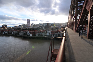
Bridge — for someone, at least.
(Photo: J.Maus/BikePortland)
It looks like inner Northwest Portland is about to get very, very different.
As various outlets have reported, the Portland Development Commission on Wednesday authorized the purchase of the downtown U.S. Postal Service headquarters for $88 million.
That means that if the city can clear up some remaining sticking points and find buyers, hundreds of daily truck trips will vanish from the Pearl District area; a major blue-collar downtown employer will probably relocate to a site near the airport, replaced by a mix of market-rate housing, office jobs and affordable housing; and the street grid between the north Pearl and Willamette River will connect for the first time in more than 50 years.
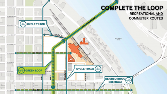
And as we reported in September, it’ll also mean three new or improved bikeway connections to the Broadway Bridge, including the promise of a route that winds straight down to the North Park Blocks.

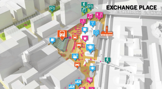
(Images: PDC)
In addition, the bike lanes on Broadway and Lovejoy are due to be upgraded to protected bike lanes. And Johnson and Flanders streets might use diverters and speed bumps to become neighborhood greenways right through the north end of downtown.
Advertisement
And the city hopes to create a new “Exchange Place,” a large public plaza in front of Union Station, that’d anchor the north end of the Portland Transit Mall.
All of this is a big piece of the vision for a “Green Loop” of low-stress bikeways circling the central city across the Broadway and Tilikum bridges. It also means (again, assuming that Portland property continues to be in such hot demand) that developers will play a big role in paying for street improvements in the area.
Developers will certainly have an incentive to make biking to the new property pleasant. The city’s goal is for these 13.4 acres to host 4 million square feet of new building in downtown but only 5,000 new daily auto trips — half the ratio for the rest of the central city.
That’d mean only 15 percent of trips to the site would come from people driving alone. Elsewhere in the central city, about 30 percent of trips come in that way.
If the site misses that target, auto parking on the site is likely to be either hopelessly inadequate or deal-killingly expensive to build.
This news makes an interesting prelude to our upcoming Northwest Portland Week. Stay tuned.
— Michael Andersen, (503) 333-7824 – michael@bikeportland.org


Thanks for reading.
BikePortland has served this community with independent community journalism since 2005. We rely on subscriptions from readers like you to survive. Your financial support is vital in keeping this valuable resource alive and well.
Please subscribe today to strengthen and expand our work.
I like that “cycle track” is listed on the map, but I’m hesitant to believe it unless I see it.
Does this mean the Post Office has to sell? It is not clear.
That would be like my girlfriend authorizing me to sell my cross bike. She might authorize me to be able to, but it doesn’t mean I’m necessarily willing or am going to sell it.
My understanding to date was that the Post Office did not want to let go of this land parcel?
From what I read in The O, USPS got the terms they want, are obtaining land to build a new facility (near the airport), and will lease the current property from the city until they are ready to move.
USPS is a willing seller. They’re going to wind up with a new facility much better suited to their needs.
This is going to be a huge deal. So far, the plans look very promising for livability. The protected bike lanes will improve access over one of the busiest bridges in the city for bike traffic. Johnson Street will finally connect all the way from NW to the train station. The public plaza in from of Union Station will hopefully improve that area and create a space that people want to visit and linger, rather than simply pass though.
It would be nice if we can get a secure bike parking facility at Union Station as part of this plan, similar to ones at Beaverton TC and SW Park MAX stations. The current bike parking situation leaves a bit to be desired.
As with most projects in this city, this has the potential to get watered down from its initial proposal, so let your elected officials know you support this project and keep up the pressure!
Michael wrote:
” including the promise of a route that winds straight down to the North Park Blocks.”
I hope the route is “straight” and doesn’t “wind”
The schematics I saw a couple months ago all had squiggles.
I straight route, where gravity would carry you on a car-free route from the corner of Lovejoy/Broadway to the Park Blocks would be sweet. No switchbacks, no zigzags, please! We’re trying to make bicycling competitive with driving here — give us a shot of 30 seconds of pure comfort and pleasure instead of 90 seconds of “WTF were they thinking?”
Good news overall, though — having the city as the landowner means they can all the shots to a pretty broad extent.
Ted Buehler
The most recent renders I have seen have the path being zig-zaggy, due to the ADA grade requirements and the small block size. I’m guessing that the city will expect people riding bikes to use the cycle track on Broadway or Lovejoy instead. Straight ramp would be nice though.
Is there a shortage in ramp construction materials in Portland? Why can’t there be two ramps – one steep and straight for bikes downhill and one zig-zaggy for wheelchairs and bikes uphill?
If they build proper cycle tracks on Lovejoy and Broadway, that would serve as an adequate ramps for people riding bikes. But I agree, there are many spots in the city (hello, Hollywood TC!) that would benefit from a separate bike ramp. Likely would still have to meet the ADA 5% grade maximum, but at least it could be straightened out.
I suspect the problem is, a straight diagonal bike ramp cutting through the entire parcel would interfere with development, i.e. buildings. City needs developers to invest many hundreds of millions of dollars here, and already wants to reserve a good party of the site for plazas and other public open space. Might not work to tell developers their high rise needs to be triangular or smaller, just to accommodate a bike flyover/ramp.
While a bike ramp would be groovy, what does it it really do, that cycle tracks on the adjoining streets wouldn’t already do? Saving a minute cycling time from the bridge to the Park blocks isn’t much of a benefit.
Also, I have my doubts about a long, steep, straight bi-directional bike ramp. The path would have to be quite wide for safety. People being people, you know there will be some cyclists descending at 40 mph amidst others descending at 15 mph and other climbing at 5-8 mph. And there’s the issue of access for emergency vehicle/personnel (the ambulance responding to the head-on bike-on-bike accident), and access for sweeping/cleaning. So now the mere bike ramp is looking more like an elevated road cutting through the site. Which sounds even less attractive, from a site development point of view.
Note that, by the time construction starts here, it might be 2020. Will it still be boom time in Bridgetown? Or will we be in the throes of the next recession?. There won’t necessarily be money to splurge on an expensive elevated road with rather limited and debatable benefits.
It has to do some switchbacks to meet ADA requirements, but I don’t think that’s going to be a big deal. Bicyclists will still have the choice to use Broadway or Lovejoy rather than going through the site.
But, but, but…
What about the long suffering Portland baseball fans who were hoping to site a new baseball stadium on this property? Oh woe is they.
There’s baseball in Hillsboro.
Speaking of which, the feds played hardball and got a great deal. the land is worth $63 million yet the PDC is paying $88 million. Post office also gets to stay there rent free until the new site is ready and the city pays $4 million to help the postal service build its new site. Portland was desperate to have the spot and the feds knew it. The PDC sloshes millions of dollars around like a drunken sailor.
The feds are also kicking in $69 million to build a new facility for USPS near the airport.
The $63 million figure is based on the value of the current property, under its current use. Once they demolish the existing building, go through a masterplan process to increase the zoning entitlements (similar to what Con-way did in NW) and divide it into developable parcels the value of the site will be much, much higher. They expect (and I think it’s a reasonable expectation) to more than make the money back from land sales.
As a point of comparison, the single block PNCA site sold to Security Properties to $11.75 million. It’s not hard to see how the PDC can get a lot more than $88 million of value out of a 13 acre site.
Of course they are planning on selling it for more than they paid for it. Every buyer does that. The point is the Feds took advantage of the ever incompetent PDC.
So, $88 million, plus $50 million in demolition costs, plus the lost free rent to the postal service ($2 million??), plus the $ 4 million relocation costs to the postal service, plus site costs for a retail post office, plus partition costs, plus staff costs, plus other costs I am sure I am forgetting. Probably looking at needing around $150 million from the sales.
How’s centennial mills working out? How much money has the PDC blown there?
The inclusion of affordable housing and protected bike lanes are certainly a good thing. It’s just that the PDC has such a terrible track record, their credibility is seriously lacking with many people in this town (their developer buddies who I am sure will get sweetheart deals – below market value – down the road. They literally wasted tens of millions of dollars and think nothing of it. The PDC useful life has come and gone. It needs to be shut down.
Why are you assuming $50 million in demolition costs? Why are you double counting the $4 million cost relocating the retail location? Why are you counting the free rent to the USPS as a cost?
the feds played hardball
I see what you did there.
WooHoo, let’s hear it for more gentrification in the Pearl. No doubt all those expensive new apartments that only rich people can afford will come with hefty new tax abatements.
Plus if you actually need to go to the Post Office for anything, downtown is a heck of a lot more convenient than out by the airport. Just sayin’…
stopppppppp. you do realize the pearl district actually has the most affordable housing units in the entire city don’t you? there are many mixed income and subsizdized buildings in that neighborhood. its not just high end condos and boutiques.
I think you mean ‘affordable’ until the tax abatements run out.
Facts to back your statement up?
I wish I could live in the pearl…but I am middle class. If you are income restricted or have tons of money, then you have the option of living in the Pearl…middle class folks don’t have that luxury.
I remember thousands of condos being sold for under $300k when they were built. I had a friend who bought one for under $200k for a studio… now worth about double that.
Get in while you can.
I’m not sure how you spend your money, but our household income has been around $80k for the past few years and we moved into the Pearl last year. We consider ourselves solidly in the middle-class income range, which for Portland goes up to a bit over $100k.
The Pearl is affordable if you want to afford it.
a) 30% of the housing planned for the USPS site will be affordable, which mirrors the current makeup of the Pearl. I don’t think loaded terms like “gentrification” are helpful given that far more low income people now live in the Pearl than at any point in Portland’s history.
b) The idea that expensive apartments in the Pearl are all getting tax abatements is probably the biggest Bojackian myth in Portland. The River District URA is loaded with money, mostly because the market rate apartments and condos are in fact all paying hefty taxes. This has helped pay for things like the new street lights that were recently installed, the streetcar, the neighborhood parks completed over the past decade, and the thousand plus units of affordable housing in the district.
c) The Post Office will continue to have a retail location in the area. The PDC is committing to finding a new location, within 1 mile of the present location.
The Pearl was originally an industrial/commercial area, of course more people live there now, because…gentrification.
Well maybe you’d prefer that the entire area north of Hoyt remain as an abandoned railyard, but I prefer what’s there now.
They are paying hefty taxes now because their tax abatements ran out after what, 10 years?
No. For example, here is the property tax records for the Wyatt apartments, built in 2008: http://bit.ly/1n6ILNK. Before it was constructed the site was generating around $15k in property taxes. In 2015 it paid $1,278,828.23 in taxes.
The other piece to add is the income tax folks pay who live there. The Wyatt is 15 stories tall, let’s assume 150 units in total. Assume average income per unit of $60,000 (very low estimate) * 9% state income tax *150 units =$810,000/year. So the building is pulling in $2M+/year in taxes, with most of the state income tax going to the state and not the city.
Property taxes are heavily dependent upon their improvement value, which is what is actually built on the lot.
Thus, parking lots generate far less revenue than a multi-storied building. Like orders of magnitude less.
PDC’s preferred concept sets aside aside 25% of the housing as affordable.
That actually got revised upwards based on City Council feedback. From the report the PDC approved this week:
Program Mix: The total forecasted development is 3,800,000 gross SF and is currently programmed one-third commercial and two-thirds residential. Thirty percent of residential SF is reserved for affordable housing.
(http://www.pdc.us/Libraries/Board_Reports/Report_16-04_pdf.sflb.ashx)
PS – how do you do do inline links?
Even better!
For an inline link, type <a href="http://your.link/here">Your text here</a>
FYI, 3.8 million sq ft. is ~95 stories worth of a Portland city block (40k sq ft).
That would make 75% unaffordable, yes?
Sure, if you want to look at the glass three-quarters empty. 😉
Be careful about cheering for jobs moving out of the core. Research says that transit/bike/walk mode share is higher if jobs are concentrated, and that commute distance is a really large determinant of mode choice.
Normally I would agree with that sentiment, but the USPS site currently has very low employment density. When the build out is done, there will be far more people working there than there are now. Assuming that those new jobs might instead have located at a site less well served by transit / bike infrastructure then it will be a net win for the city.
Trucking makes really poor compatibility with downtown businesses and the density of pedestrians and cyclists. More trucks = more peds flattened.
This is a good move, by all means. Plus, the USPS ships a lot of its cargo by air; a shipping center at the airport is more accessible to both air freight and freeways than downtown Portland. Ie, you are going to have less heavy trucks shunting freight from PDX to the USPS main facility if its physically located at the airport than where it is now.
Now, if only facilities on the broadway bridge could be improved.. Have extensive lane closures convinced anyone else that cars and streetcar can share, leaving a full lane for cyclists?
No they haven’t. The bridge is a parking lot during peak hours which KILLS transit reliability. And it’s not just the streetcar. The #17 bus uses the bridge as well.
They can’t reopen those outer lanes soon enough.
What about making the center lanes as transit only? If they go back to being shared transit/auto lanes, they’ll just get jammed up again once the outer lanes are open.
Hmmm… has money to buy the post office and none to fix the streets?
Let’s hope the city does a better job of coordinating with the county about connecting to the bridge than they’ve done with the Burnside bridgehead project.
“Market-rate” is a nice, warm fuzzy euphemism for “luxury” housing. Using it is marketing-grade journalism.
No it’s not. I live in market rate housing. I don’t live in luxury housing.
I was headed “in” today near 5pm, so I knew the only sidewalk would be full of “out” traffic. I elected to use the lane instead. It was at full gridlock, so basically I was just filtering along the side. But there’s about 5 feet to the right of the first rail, which is perfectly fine for riding (at least when I’m not worried about being overtaken).
I was able to slide past all cars, but a big truck and a bus were too wide, so I had to wait behind them for a while.