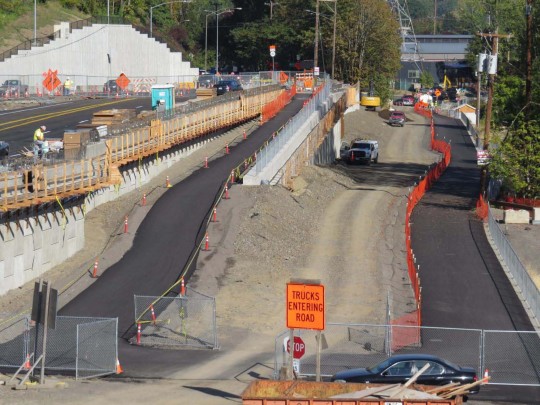
(Photo: Multnomah County)
Multnomah County has made major progress on the Sellwood Bridge project and at the start of next month they’ll flip the switch on a traffic change that will impact your bike ride.
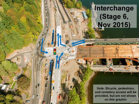
In early November, people using the northbound lane of Highway 43 will begin using new interchange ramps and the southbound lane will be routed under the new bridge. If you’re headed from the bridge up into Riverview Cemetery, you’ll use a new entrance (a bit further north than the existing entry location) that lines up with the new interchange.
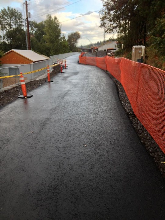
This week the county released an updated image of progress on the new paved multi-use path between the bridge and Macadam Bay.
Here’s an aerial photo showing the progress as of September 12th.
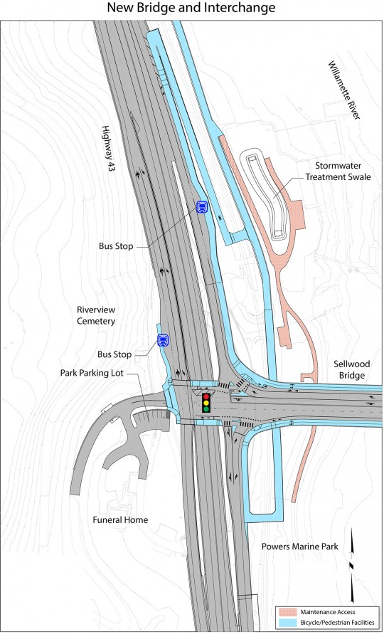
And here’s how the connections will look once it’s completed (bikeways/walkways are bright blue)…
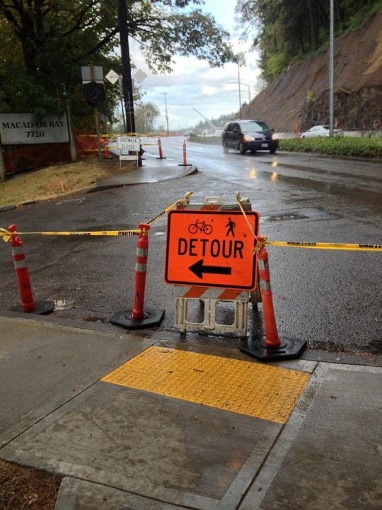
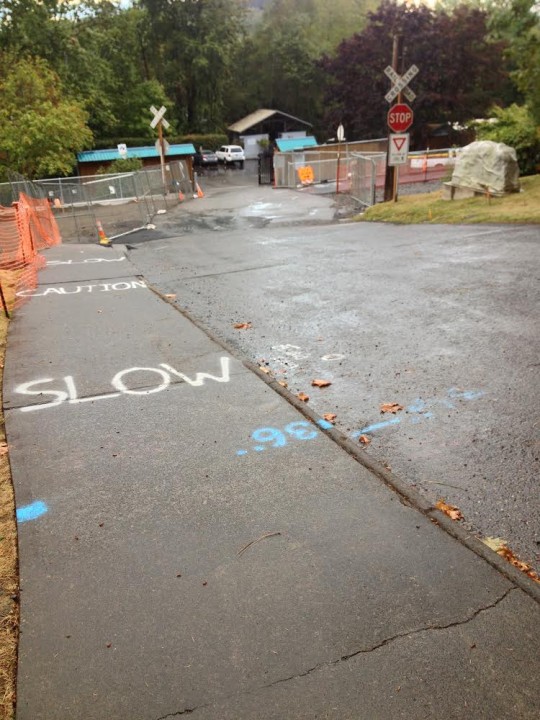
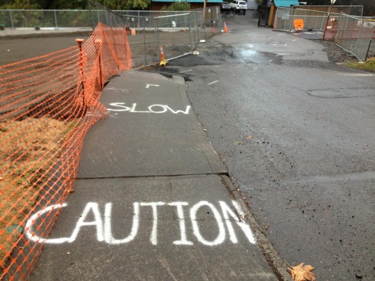
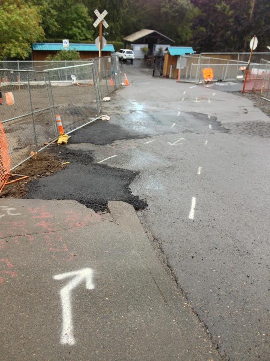
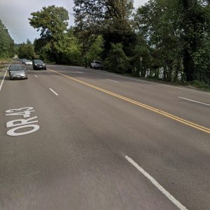
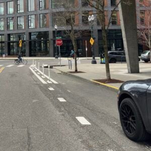
Meanwhile, the bicycling detours around the west end of the bridge continue to demand caution. Reader Gretchin Lair sent us a note and photos showing how the county is routing people from the sidewalk on SW Macadam down to the new path.
“These photos don’t show the pitch well,” Lair wrote, “but it is terribly steep, has awkward angles, and an uneven transition zone. It feels incredibly dangerous, so much so I felt compelled to walk my bike in this stretch.”
Advertisement
Once built, the bridge will have 6 and 1/2 foot wide bike lanes, 12-foot wide raised paths, and two, 12-foot wide standard vehicle lanes. The bridge is expected to open to traffic in spring of next year and be 100% complete by November.
For some of you, the new Tilikum Bridge offers an excellent way to avoid this area. But for those of you still taking the Sellwood regularly, how are the detours and ongoing construction zone treating you?
For more information about this project visit SellwoodBridge.org.



Thanks for reading.
BikePortland has served this community with independent community journalism since 2005. We rely on subscriptions from readers like you to survive. Your financial support is vital in keeping this valuable resource alive and well.
Please subscribe today to strengthen and expand our work.
Looking at those aerial views my first thought was ‘what a sea of asphalt 43 has become at the bridge head!’ I’m looking forward to the changes on the bridge itself, but the addition of so many N-S lanes comes (to me) as somewhat of a surprise.
Yeah – and it seems to me that the ODOT-required giant bridge interchange has a lot of benefits for Clackamas County car commuters (Lake Oswego is in Clackamas County) and few for Multnomah County residents.
And a ton of benefits for cyclists. Look at how much easier getting to the cemetery is going to be, no more weird under loop to a very long traffic light.
The project as a whole – for sure, it’s going to be awesome!! The interchange design required by ODOT – not sure. Do you have more information on what type of design the County would have implemented without ODOT’s influence re: the Hwy 43 interchange? I just know that ODOT’s required changes were expensive and assumed that they were motor vehicle-oriented but don’t know for sure.
I don’t know.
I don’t know that this new design is that much different than the one it’s replacing though (regarding car interchanges).
Hm. I did a little research on Google Maps’ old photos and it looks like there used to be four lanes total, two each way (one through-only lane, one turn lane) although the setup was kind of wacky. The new interchange looks way larger to me – eight lanes total, four lanes in each direction (two through-only lanes, one through / turn lane, and one turn-only). I do know that the project involved blasting into the hillside so the footprint of the interchange is indeed significantly larger than what was there previously.
Thanks for the electronic ground truthing, Alex.
Kind of reminds me of the CRC it-is-not-a-bridge-project-but-a-highway-expansion-project
Yeah, it’s tough to tell from that diagram above if there are two lanes going under the intersection in both directions or just one and some kid of a shoulder.
http://www.sellwoodbridge.org/?p=project-area
These picture make it look like only four lanes total on the new bridge (with only one each way thru lanes). So unless things have changed it’s not going to be more lanes than it used to be (well there will be a lot more bike lanes 🙂
Oh good point, it looks like one of the areas I was interpreting as a through-only lane is in fact going to be a shoulder. Based on the rendering you linked to, it looks like there will be three lanes each way (through-only, through/turn, turn-only). Still an increase from two but not as drastic.
I see four lanes total (which is the same as previously). Are you reading some of the bike lanes as auto lanes?
Well, Clackamas County car drivers may reap a big chunk of the benefits of this project, but at least they didn’t pay for it. :-/
Does that bike path in the photo connect to anything to the north? I know there’s a MUP around that area and I assume they would be connected.
Also, still confused why the county decided on two different bike facilities on the bridge. Why not leave the sidewalk for people walking and install raised bike lanes instead of paint? Once you remove the bike markings from the sidewalk, it can be narrowed a bit. Instead of 6.5 feet bike lane and 12 foot shared bike/walk sidewalk, why not an 8.5 foot raised cycle track and 10 foot sidewalk?
The path helps to connect to the dead-end of the Willamette Shore Trolley where the trolley stops at the charter school that is near the old Spaghetti Factory. It helps to connect to SW Moody.
I think some people wanted to use the bridge’s bike lanes to be able to pull over for police cars.
Yes, it’s a replacement for the existing MUP (a bit laughable to call it that, as the stretch it replaces was about 4 feet wide with walls on both side at certain points). It connects to Willamette Park via a jaunt on Miles Pl., which then turns into the Greenway all the way to South Waterfront (excepting the well-known missing link).
I haven’t figured that out, either. I think it’s cool there is a “commuter” lane and a “tourist” lane (my words), but don’t understand why the former is at street grade. I’m a little bit scared it allows those 2 bike lanes to be converted into car lanes in the future, perhaps to accommodate the streetcar if that ever happens?
Also they wanted to leave space for an emergency lane to be made. There is just more flexibility in the roadscape with the on street bike lanes.
It’s the best of both worlds. For all the people who complain about bike traffic on the Hawthorne bridge this should help a ton. Families and slower riders can stay on the sidewalk level, and faster riders can stay on the street level. The street level makes the connections easier (or at least I hope that to be true).
I think they’re recognizing that there are more cyclists than pedestrians on this bridge.
you can’t bike on the sidewalk if there’s a bike lane next to it… mandatory bike lane laws and whatnot…
It’s a bike facility on the sidewalk though.
I don’t think that law would apply here (though I’m not a lawyer, I have to imagine this has been looked at).
Tell that to all the cyclists on SW Lincoln who think too much of their time to cross the street to use the bike lane and so little of the time of people walking around that they yell at them to dart out of the way to make room for bikes. Without regular enforcement you’ll have families and slow riders on the sidewalk, and there won’t be any enforcement.
You can ride on the sidewalk anywhere it isn’t expressly prohibited (ORS 814.410 (2) — it may even have to be written, rather than just posted (wondering about the east side of Moody since Portland ordinance 16.70.320 doesn’t mention it.))
The sidewalk will have sharrows and be explicitly family friendly. The commuter lanes will be made of tinted green cement last I heard. It is level with the street not only for emergency pull over, but also for ease of passing.
The easy answer to your question is flexibility. Making three different levels of roadway doesn’t give any flexibility for emergency vehicles on the bridge (essentially allowing for a 3rd lane). It also doesn’t allow for easy passing of other cyclists. They also can always go back and change the lane structure if they want to (removed the sidewalk bike lane, or even protect the street level one).
And frankly I would feel more comfortable cycling with my kid on this sidewalk (which is separated from cyclists who want to go faster) than a single separated lane where a faster cyclist would have only a few feet to safely pass my kid. Sellwood is a big “family” neighborhood, and I wouldn’t be surprised if this factored into the choices of bike facilities.
I wish the bike lanes on the bridge were protected ones. However, the new bridge is a great upgrade to the old status quo. I wonder what effect might take place for the nearby businesses once it is done?
“Better than before” is not the best metric of success. We’re getting an entirely new bridge; there’s no reason why world-class cycling infra should not be installed.
I’m failing to see how this is not “world class”.
no separation of modes… not even close to world class… not even close to being done the right way…
http://www.sellwoodbridge.org/files/renderings/belvedere–bench-plan-view.jpg
So there is a raised bike “lane” on a share walk (like Hawthorne but wider), in addition to the street level lane.
I think having two facilities: one protected and one bike lane, going in each direction is “world class”. It’s exponentially better than any other bridge in the city.
You’re either sharing road surface with people driving cars or sharing sidewalk space with people walking. In either case, there is only paint separating you from the other mode. World-class would mean a grade-separated bike lane that is at a different level than both the car lane and sidewalk.
Adam, I dont know how long you’ve been riding across the Sellwood bridge, but I’ve been going across that sketchy narrow light poles in your way sidewalk for the last 28 years and the new bridge is going to be so much better. Is it perfect? No, but nothing is. ***sentence deleted by moderator – please refrain from insults and name-calling — Jonathan*** Lets celebrate that this new bridge has given bikes and pedestrians a much safer and more enjoyable way to cross the river for us folks on the south end of town.
No joke. This is probably going to be the best piece of cycling infrastructure in the city, (I mean we’re talking 6 lanes on this bridge for non-car travel versus 2 for cars!) and is replacing a woefully inadequate one.
Sometimes I just have to laugh at this site.
“Sometimes I just have to laugh at this site.”
or, more specifically, at the occasional entitled whopper comment. I know this is not something Jonathan would do, but we could have a weekly feature, sort of the inverse of comment of the week.
Does that mean they would have to send bikeportland $5?
Good one!
No infrastructure will ever live up to the standards of us bikeportland commenters.
No infrastructure will ever live up to the standards of [some of] us bikeportland commenters.
I’m not saying that the facility won’t be great or won’t be significantly better than before. My point was that we’re spending millions building a brand new bridge from scratch. There is no reason why we can’t get the best possible cycling facilities available.
We can’t just constantly strive for “better than before”. We need to do things right the first time.
And your definition of “right” is different than others. Personally I would find a single “protected” lane (as you described it) as a worse option that what will be on this bridge. This option provides for cyclists of different speeds to better coexist. This isn’t a bridge ONLY for cyclists, they have other constraints to consider as well.
The bridge has a protected bike route on the raised path (similar to the tilikum).
Not really. It’s a shared sidewalk, like the Hawthorne Bridge (although wider).
and without most of the fast bike traffic.
i ride this every day. i actually like it when i ride along that conencts to the sidewalk. the brief detour that led down and up that ramp was horrible. I was happy to see they re-opened up the section again to avoid that steep ramp.
I wonder how much better it’ll be once the bike path connects to Willamette Plaza corridor (what is that side called anyway? eg: eastbank esplanade). and if it’ll be extra time-consuming or not. I ride mostly on the sidewalk to the end of Willamette Park Plaza because i’m tired of the constant swervy pathways. couldn’t it be just a straight way?
random: it’s actually a 5 minutes shorter of a ride when on the sidewalk than on the river pathway to OHSU Tram.
The pathway between the bridge and the South Waterfront could use a lot of improvement. It’s really twisty with lots of blind curves, so you can’t go too fast. It also has a ton of raised bumps, from tree roots I guess. It would be awesome if those at least could get ground down. In my dreams, they would put in a path that follows the trolley right of way. Then it would be as awesome as the Springwater.
It is slow and bumpy, but looking east it is one of the prettiest rides in the area.
>the brief detour that led down and up that ramp was horrible
I liked that better actually. The bridge sidewalk is uncomfortable to ride on, a short break from riding right next to traffic is nice to have after it, even if it does take a few extra seconds.
I cross the Sellwood Bridge by bike around 4x/week, but my destination is Lake Oswego. The Sellwood bike lanes will be great once they’re in place, but it won’t make it any more real that I’ll be able to take my kids into Portland by bike, until the OR-43 bike corridor is addressed – however it gets addressed. Right now, my only option is up through the Cemetery (~450′ climb) and then all the way back down through Tryon Creek, seeing as doing the 43 by bike is just completely unsafe.
Desperately waiting for that to get sorted – whether the trolly tracks are used as a right-of-way, or whether the mixed-use bridge near the rail bridge end up as the option.
Why don’t they let cyclists use the street for that detour instead of the sidewalk??? Personally, I’d move that detour sign and use the curb ramp to enter the street at the top of the hill.
That’s actually what happened a few days after this was set up 🙂
Seriously? Because after I ran across this detour I refused to take that bridge again. So if the detour isn’t there anymore, I would consider it again. I can’t wait until it connects to the Greenway again. The Macadam sidewalk is so terrible.
The switchback baffles me a bit. It seems excessive–not all that much of a elevation delta. It’s quite an extended route to get from the bridge down to the path. Don’t get me wrong, it’s leaps and bunds beyond what was there before, but I wonder what pushed that particular design versus more of a straight shot.
Probably ADA. I believe that the grade must be less than or equal to 5%.
The grade is definitely no more than what is on the Tillikum
Because it’s a sidewalk, not a bikeway. Maybe one day we’ll build a bikeway somewhere.
I understand that. What I’m getting at: Only the middle leg of the 3-legged switchback has any grade at all. That is the 5% part. Then you have the stretches along 43 and on the MUP that are essentially flat. A straight shot from MUP up to the bridge could easily make that grade. I’m sure it’s just due to space limitations at the site, not a big deal, just a minor annoyance.
I agree: it doubles the distance to the bridge unnecessarily.
My guess is that the path has to allow for maintenance vehicle access along the river.
And that switchback clearly shows that engineers in this city/county don’t understand how bikes work. Most people can’t make that sharp of a turn on a bike without nearly coming to a complete stop.
I don’t know about the eventual switchback at the top, but the path for the one on the bottom is actually pretty wide. If you take the right line, you can easily hold 15mph through the turn.
I take your word for it, so perhaps the scale is much larger than it looks in that photo. Still, there are plenty of examples where people riding bikes are expected to make sharp 90º turns. Crossing SW Moody from Tilikum heading west, SE Tilikum Way and Water Av, approaching SE 8th from the west on the Orange Line MUP, the short buffered bike lane/bike box crossing of Division on 41st, etc. Many of our “bikeways” are really just sidewalks (designed for people walking) that you’re allowed to bike on. The angles and turning radii needed for efficiant bicycle travel are rarely taken into account.
Agree that the crossings and turns on the ends of the Tilikum are a disaster. The Sellwood bridge path will have NO crossings, and the turns are WAY wider.
Why do engineers insist on putting multiple 180 degree turns into bike infrastructure.
Drivers would lose their minds if they had to pull a 180 degree turn to get from I84 to I5 South.
There are a number of highway ramps that go 270 up to 360 degrees (though now that I think of it the ones I’m thinking of are mainly up in Washington).
Yes, but those are completely different. They allow drivers to take the turn at speed, without stopping. This new design forces the user to slow down or almost stop, and it creates a bad pinch point.
If this was an important connection for cars, it would have been made better. But it’s not, so it wasn’t. There should really be a design guide for bike travel that ensures users can ride at up to 20 mph on paths without having to stop unnecessarily.
The above poster says he can take them at 15mph. I wouldn’t call that stopping.
And most of those highway ramps are signed at 25-35mph (compared to 65 on the highway.
I don’t think it’s as discrepant as you think.
I’m curious what else you would propose to do if they are limited by a certain grade (due to ADA)?
Sometimes highways have switchbacks. They tend to look like this.
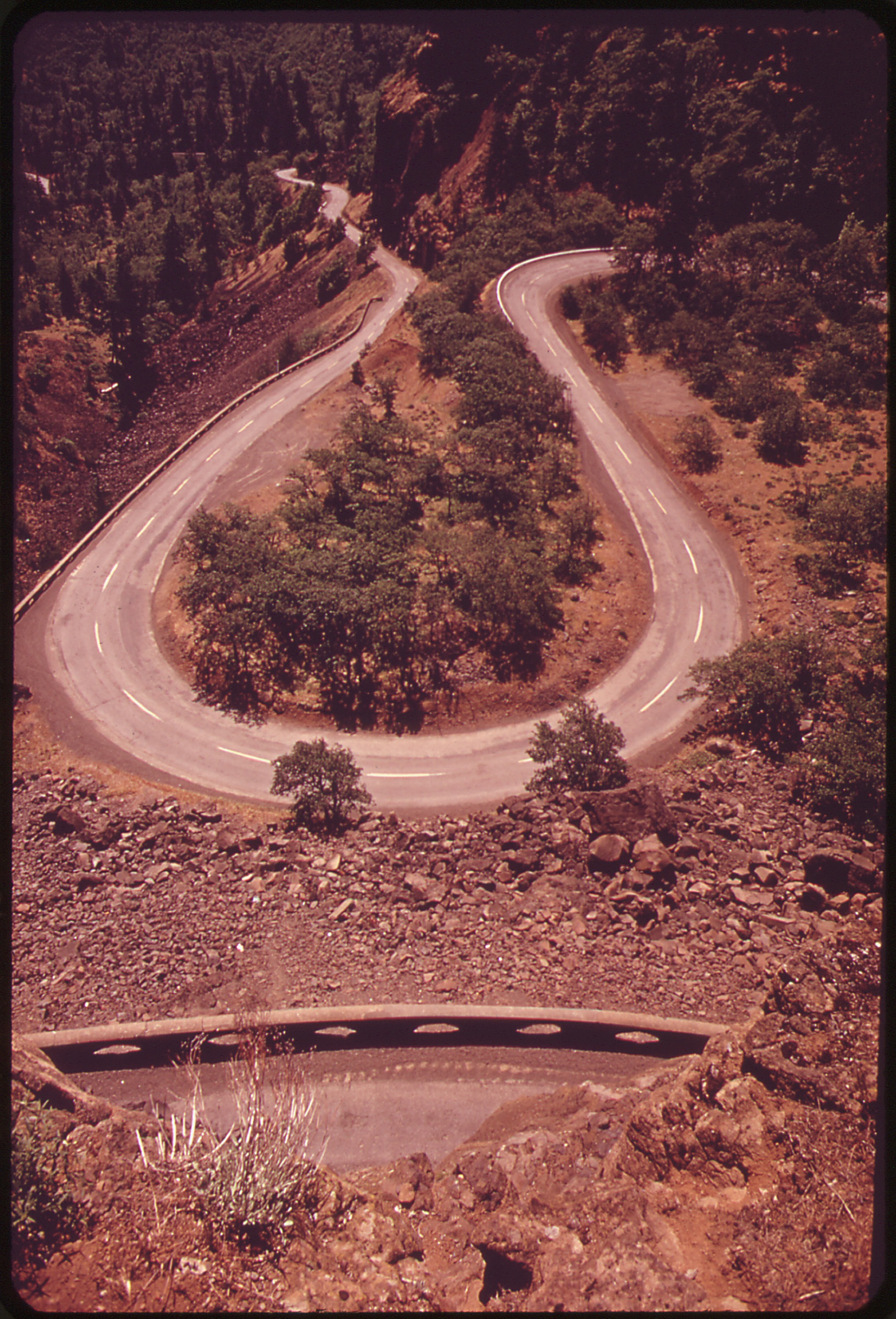
It’s a tight turn and you have to slow down a lot, but notice the lack of right angles? Now look at the picture at the top of the page. Doesn’t it look like they could have rounded the corners at the bottom switchback in a comparable footprint to the right angle one they built? I don’t see an obvious reason they couldn’t have. Maybe they will before the project is finished.
http://imgur.com/6GH50cp
other link didn’t work.
I hate the switchbacks here. It just makes it harder to turn on the hairpins.
Didn’t the builders float the idea of moving all the bike/ped traffice to one side and car traffic to other…and they would have saved a few bucks also…
Seems like that would work perrty well to have all the bike/ped access on the north side..on both ends of the bridge…
They DID but it ended up being messy on the ends and not condusive to continuing the trail south to Powers Marine Park (and, eventually, Lake Oswego). Also: they proposed it at the last minute after citizens spent many many months hammering out the details of this plan.
Sorry to nitpick, but is it major progress if they’re this behind schedule? Wasn’t the new bridge supposed to be open in 2015?
I know they lost a lot of time when they had to do more work than anticipated on the pilings.
I guess I’m not crazy.
Found this on the project website:
“A detour bridge is carrying traffic until the new Sellwood Bridge opens in 2015.”
http://www.sellwoodbridge.org/?p=project-area
Late, over-budget. Not surprising when you have an over-designed mess that can’t close to vehicle traffic for more than a few days. They could have done this bridge for half the cost and a third of the time if they had simplified the interchange and demo’d the old bridge prior to building the new one.
Except there is no alternative crossing for 3-4 miles in either direction. Just closing the bridge for months and months wasn’t a very good option either.
One thing I’m really looking forward to about this bridge is the connections are going to be so smooth, compared to the Tillikum bridge. You will be able to just ride on and ride off without having to wait for any signals (except if you want to go into the cemetery)
Another thing.. I ride this a couple times a week, and through all the detours, I really gotta give it to the managers for keeping access to bikes/peds. There’s many times where you could tell it would have been way easier to just give bikes/peds a big FU.
November 2016? Am I reading that right?
Sorry for not being clear. I’ve edited the post.
County says bridge will be fully complete by November 2016 — BUT it will open in spring.
Phew, you scared me for a minute there.
Looks like another world-class platinum job of getting bikes out of the way so people in cars can drive over the speed limit. I guess we’ll see how the stop light timing gets setup, but when I saw that the new path had a switchback which probably leads to more sidewalk detours, my response was to take the lane on Macadam.
I have always taken the traffic lanes both directions on the Sellwood bridge including Macadam. The bike lane used to be useable only if you were walking the bike. I also never held up traffic when I took the lane. I took a good run at it and pumped adrenaline.
I am excited for the finished product. They have been doing a great job accommodating cyclists throughout the project. All the workers have been very friendly to me. Remember when they had flaggers controlling the traffic at the west side earlier this year? There would be huge lines of cars, and the guys with the flags would always stop everyone immediately as soon as a bike showed up. I don’t think I ever waited more than 10 seconds at the intersection to get to the cemetery.
Today’s temporary path is adequate, but will get better as the work continues. Riding it these past few weeks, I find the temporary infra not bad at all. Sure there are some 90 degree turns, some grades etc, but nothing that slows me down considerably. But I also enjoy riding technical off-road singletrack on my cross bike…. One’s impression has a lot to do with their frame of reference.
Lets support this awesome project and all involved and drop the entitled ninny whining. whaddya say?
Thanks for this post on the bridge. I was one of the consultant engineers on the project.
ODOT’s requirements for an interchange with ramps that met mobility standards (aka designed for trucks) was a big driver of the design early on. We were not able to acquire cost-cutting design exceptions for many of the clearances, speeds, and geometry we were looking for. Among other things, this affected wall designs and costs.
Although ODOT played a big role, money was main the main driver of design decisions on the project. ROW and land use permitting is costly and the process is lengthy. We knew money would be tight from the very beginning, then we found out we needed to cut another 25-30M off the cost because of Clackamas County. That was a sad day. Of course we would have loved to demo the old bridge and build the new one in the same place. Who knows how much savings that would be, potentially 10-15% of the project cost? Just look how much they’re spending on flagging alone!
A lot of thought went into the bike-specific design and “user experience” ON the bridge. There will be a ton of walkers and cyclists who want to stop and look out over the river and take selfies, so we needed big sidewalks that could accommodate both modes. Commuters, fast/confident cyclists, and those who have already seen the view can ride down on the road with the cars. There are several reasons why raised bike lanes adjacent to the motor vehicles and below sidewalk grade were ultimately weeded out. Cost/benefit, constructability of mountable curb, complications with drainage and the need for two extra feet of shy (four feet total) ultimately killed the raised lanes.
The bike detour was real bad. There’s no other way to describe it. I gently pushed for a protected bike lane on OR43 during construction, but struck out. Shame on me for asking for a reduction in trucking mobility on a state route. However, I’m proud to say I attended all my meetings (east side of bridge) and site visits via bike, taking the lane on OR43 and on the bridge. Only got honked at a few times.
The MUP and switchbacks north of the bridge were designed as an accessible route (ADA-compliant) and not designed as “bike infrastructure.” You’ll find that all the fencing, 180-degree turns, and all the other cyclists taking wide corners and riding two abreast will make it a pretty tight corridor. Cyclists should ride slowly. Independent of the ADA path I wanted a separate, direct-route bike path from the bridge directly down to the path with very steep grades. Maybe 10-15%? It would have been rad for sure.
All in all, the engineers and planners were very dedicated to designing this facility, meeting the requirements and wishes of all the stakeholders involved, and are doing a commendable job seeing it through construction. They really did the best they could, given the constraints.
Thanks for the great insight! As with any project, it comes down to compromises. No matter how it turns out, it is light years ahead of the old bridge and I am grateful for that.