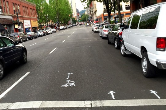
(Photo © J. Maus/BikePortland)
Nine months after a three-day event that tested a single southbound lane of auto traffic on a few blocks of NW and SW 3rd Avenue, a group of stakeholders on the street has endorsed a middle ground: two lanes.
“It builds on a future expanded plaza for locals and visitors at Ankeny Alley that will become a regional destination.”
— Old Town Chinatown Community Association
The proposal endorsed unanimously this month by the 3rd Avenue Stakeholder Advisory Group would replace most of the rightmost travel lane with a buffered and possibly green-painted bike lane for six blocks from NE Davis to SE Stark.
That’s the word from Ryan Hashagen, chair of the advisory group, which is a subcommittee of the Old Town Chinatown Community Association. In a letter to the city delivered yesterday, the OTCTCA wrote that the proposals “stemmed from community demand for a safer, more walkable Old Town Chinatown for residents, visitors, locals and tourists. It builds on a future expanded plaza for locals and visitors at Ankeny Alley that will become a regional destination.”
Sarah Stevenson, executive director of nonprofit Old Town housing provider Innovative Housing Inc., said the plan would preserve people’s ability to turn left onto Burnside from 3rd while making the neighborhood “less noisy, less traffic-y.”
“I think it’s a great plan, because there’s a little bit of something that makes everybody happy,” she said. “I have never seen a plan that has had the support of every Old Town Chinatown stakeholder, and this seems to have hit that sweet spot. It’s going to make everything safer, more pedestrian-friendly, more bike-friendly, which is good for everybody.”
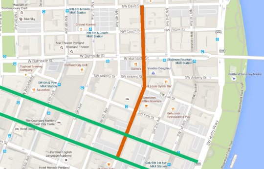
(Image: BikePortland)
For people who want to get to the area by bike, the proposed changes would create a new, relatively low-stress southbound route from the Steel Bridge area to the painted bike lanes on SW Stark and Oak streets, starting to build the first connected network of bike lanes in downtown Portland.
“We’re seeing a lot of pedestrian traffic down in this particular area and a lot of bike traffic,” said Chad Stover, a staffer for Portland Mayor Charlie Hales who has coordinated the project. “We want to make the flow of all traffic as smooth as possible and as safe as possible. … If you’re a pedestrian right now when you go across the street you can sometimes be taking your life in your hands because you have three lanes of traffic coming at you.”
“It’s very strange how many lanes there are,” said Lisa Frisch, downtown retail development manager for the Portland Business Alliance, a regional chamber of commerce. “It doesn’t make sense going from three into two into three into five.”
Advertisement
Hashagen said a city transportation analysis concluded that two lanes on 3rd Avenue were enough to handle all of 3rd Avenue’s auto traffic with no additional delay, even during rush hour. The changes would also preserve parking on both sides of 3rd Avenue. (A plan endorsed last summer by a different group of retailers would have eliminated auto parking on 3rd Avenue in order to add in-street seating and planter-protected bike lanes.)
The Portland Business Alliance supports the plan because its members in the area do.
Frisch, who sits on the advisory subcommittee and who made the motion for the group to endorse the two-lane redesign, said that like Stover, Hashagan and many local business owners, she would love to see retail shops in Old Town Chinatown’s entertainment district “open during the day and not just at night.”
Frisch said she believes the number and nature of traffic lanes on a street has “zero impact” either way on whether people are more likely to shop or spend time in the area. But she said the PBA supports the plan because its members in the area do.
Helen Ying, chair of the community association, said she thinks walkable street design is one of various factors involved in retail health.
“I think by promoting safety and transportation, what we’re doing with 3rd Avenue is going to help with bringing foot traffic and bringing more people into the area, and that’s part of the revitalization plan,” said Ying.
Adequate on-street auto parking is also an important ingredient, Ying said, especially if the area wants to do without surface parking lots.
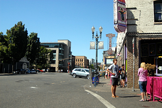
Ying alluded to discussions over the last two years about whether the wide roadway in front of Voodoo Doughnut and Ankeny Alley could eventually evolve into a “Times Square type” area.
“We’re not there yet, but I think this is helping to make steps closer to that,” Ying said. “I think the design with incremental improvements is really the way to go. It’s baby steps.”

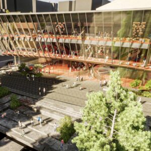
(Image: Ankeny Alley Association grant application)
Next week, a proposal to use bollards in the roadbed to pedestrianize some of the plaza at Ankeny and 3rd will go before Portland’s Historic Landmarks Commssion. According to the commission’s agenda, “Phase II (not yet designed) anticipates new paving, new curb lines, lighting, and other permanent site fixtures.”
The city has prepared a possible rendering of the possible 3rd Avenue redesign and presented it to the Old Town Chinatown Community Association, but said it won’t share the image with the broader public until more stakeholders had seen it.
“We don’t want to put anything out there in print that would overcommit or make it seem like things are firmer than they are,” city transportation spokesman Dylan Rivera said Monday. “We’re excited that the community’s excited.”
From here, the city plans to talk with more businesses on SW 3rd before developing the plans further. Stay tuned.
Correction 4:40 pm: An earlier version of this post reported that Hashagen said the proposed bike lane would be colored green. He says that is only one option being considered.


Thanks for reading.
BikePortland has served this community with independent community journalism since 2005. We rely on subscriptions from readers like you to survive. Your financial support is vital in keeping this valuable resource alive and well.
Please subscribe today to strengthen and expand our work.
A door zone bike lane? Baby steps indeed…
What’s the point of doing this when we could be doing something better?
Isn’t that the buffer?
Unfortunately, “buffer” often translates into “extra parking space” for people incapable of parking in a standard sized spot.
And, buffers aren’t often painted wide enough. That van door would easily extend into the hypothetical bike lane.
Hashagen said his understanding of the current proposal is that the bike lane and buffers would be a total of 12 feet wide, but everyone else I talked to said that’s more detail than they felt able to talk about.
I’m sure it will be reduced in width by the time it’s fully planned. And then, it will lose some width before it gets implemented. And after it’s implemented, half of it will be used by drivers for their “extra” parking space.
… For 6 blocks. Because nothing says commitment to bikes like making a 6 block bike lane. Who cares if it connects to anything? Who cares if people literally die at the end of the lane?
Imagine if the CRC was promised, planned, and paid for. Then, when it gets built, people notice it’s only 6 blocks long. On one end, it might connect to the highway, and at the other end it would drop straight off into the river.
Not very useful, is it?
your hyperbole mutes any effectiveness you may seek to achieve.
It’s easy to criticize – super easy. Any constructive solutions?
Can you imagine the time it would take to get a lane the full length of SW 3rd?
Seems to me a small project, supported by local businesses, is a pretty good step toward demonstrating how non life altering such a change is.
If the local businesses only do better, how soon before other parts of the city will want the same thing.
It’s happened in NYC, it can happen here.
Here are some solutions:
Change right turn from NW Glisan to NW 3rd to be bike only. Remove the bumpouts on NW 3rd and replace them with a full-width bike lane with physical separation and pedestrian islands.
Remove all on-street parking on the West side of the street.
Buffer bike lane with bike parking (where space is available), and pedestrian islands at intersections.
Continue this setup until SW Market. Add separate phases for bikes/pedestrians and right-turning cars.
While the others sound good, and expensive, the one block conversion on Glisan 4th to 3rd I don’t get. Who would use it?
Glisan is one way westbound (except for that one block) and 4th is one way northbound, so the only entering traffic comes from 4th.
Is there some significant auto-bike conflict with users going north that want to return heading south?
It wouldn’t be nearly as expensive if it had been designed properly originally.
But PBOT likes to do things the dumb way. When I asked them about bumpouts and bioswales on Division preventing future bike lanes, they said they would just remove them in the future if needed. They don’t make infrastructure that’s designed to last.
The reason for keeping cars off that area is because there’s a strong likelihood of low-income housing going up in that area. It would be nice if they had bike access right up to their front door.
Change directions as much as you want. You start off complaining about 3rd avenue – which was designed 10+ years ago, then shift to Division. ten years ago there were no greenways. Imagining that everything can be done correctly the first time, forever, is kind of naïve.
Paikiala, I think you might be having some reading comprehension issues. I’m not “changing directions” – I’m illustrating my point.
IIRC, Division was redone in 2014. The bike plan has been on the books since 2010. They should have known to make the design compatible with the bike plan from the get go.
I don’t know when 3rd was designed. But the point is, PBOT doesn’t think things through fully.
How long would it take? Why? It sounds like you’re assuming 12ft lanes are needed. What if they were 9ft wide? Seems like you could paint that in under a day to make a continuous 6ft lane without even shifting the parked cars around. What policies and plans are keeping this from being done already?
I think paikiala just likes to make excuses for the status quo and doesn’t want to make it any slower or more difficult to drive around the city as fast as possible.
Ethan,
It is best to address responses on this blog since you have no way of knowing who someone is responding to the way the format is set up.
Eric, who are you asking, and about what?
Great. Next steps: extend it to along 3rd to SW Market, and couple it with bike lanes running the length of SW 4th.
I think you have a “4” where there should be a “2”.
Why ride up to 4th to/from *any* of the bridges, much less for the privilege of contending with Pioneer Place traffic? It’s not like 2nd Ave is completely out of the way from PSU.
Iain is right – 4th is much better than 2nd for everyone south of Market. You must not have to commute to or from the PSU area very often, because otherwise you would know how awful the traffic is on 4th almost every weekday afternoon.
I’m familiar with the traffic on 4th, hence the preference for 2nd…
So how does someone leaving from PSU get to 2nd? While avoiding 4th, Market, or having to go down a flight of stairs?
I usually don’t clamor for downhill bicycle lanes – 19 hours of the day 4th is a great street to ride on – but when you are forcing cyclists to either a) sit in traffic and choke on exhaust fumes, b) squeeze between slowly moving cars and parked cars (creating multiple right hook/dooring hazards) or c) take the sidewalk, then it’s a significant safety issue and something needs to change.
2nd is the easy street to pick. 4th is the right one.
Which part of PSU? Heading east, I’d take College, cross the food carts onto “SW Pedestrian Trail” (as it’s marked on Google maps, at least). It goes by Lovejoy and Pettygrove, dumping onto your choice of 2nd or 3rd at Market.
That route runs into the “having to go down a flight of stairs” part, which is fine if a few people do it but would never scale well if hundreds tried to do this everyday. Both 2nd and 3rd have them, but at least 3rd has decent bike channels.
Where are the stairs?
Granted it’s a pedestrian path, so it’s not going to stand up to lots-of-commuters volumes of traffic.
They’re at the base of 2nd and 3rd, just south of Market. I dismount and go up the stairs at 3rd on my way to work everyday.
No, I meant 4th. 4th continues south of Market, and connects to Barbur Blvd. It’s also closer to the core of Downtown. The fact that is would be near major destinations such as Pioneer Place is a feature, not a bug.
There is an existing bike lane between Madison and Market. They just need to extend this a few more blocks to Madison. What the heck? You already have the paint trucks out. Why not do a few more blocks and make something useful?
Oh, and when the paint trucks turn around to head back home, have them do 2nd Ave on their way.
Thanks to traffic coming off from Morrison Bridge, AM peak volumes on 3rd south of Stark are much higher than north of Stark. That’s probably one reason why this lane will end where it does, in addition to providing connectivity to the Stark/Oak lanes.
Easy solution: remove the turn to 3rd. Most of the drivers I see making that turn either fail to stay in their lane or drive too close to pedestrians for comfort.
Reza,
Traffic calming coming off the Morrison bridge? Bumps? Circles?
`handle all of 3rd Avenue’s auto traffic with no additional delay, even during rush hour. The changes would also preserve parking on both sides of 3rd Avenue.` — priorities.
‘no additional delay’ is a bit off. All the auto traffic should be able to get through a signal most of the time, it’s just the queue will be a block or more long occasionally and may seem like some to be reduced capacity.
The green lane part of the story would be news to the City.
Go figure, the businesses like people who drive to have a convenient space to park.
Then perhaps, the business can provide off-street parking for its customers.
And their employees. I was eating dinner outside of a restaurant in the extremely busy, hard to park, unmetered section of Hawthorne last night. The staff member who brought us water left 15 minutes into our meal. He walked out of the restaurant and stepped into his huge pickup truck, which was taking up two spots right out front of the restaurant.
Clearly, parking for customers is important.
You should have pointed that out to the manager/owner (and you still can) most retail/restaurants have policies in place that employees must park away from the business not taking up the rotation of street parking from customers.
As a retail manager I have always made it very clear that my employees never park within 2 blocks of the business, I’ve fired people for doing that. its selfish and disrespectful to the business.
I was hoping it would run the full length of 3rd.
Please, Portland, don’t use the spring loaded, plastic covered pieces of crap that Seattle used for a buffered bike lane. See the Bicycle Quarterly blog for a further explanation–those plastic posts have a nasty surprise hidden underneath.
The ones placed on the bike lane line, and not inside a minimum 2-foot buffer?
You see what the correct design would be, I hope?
Wrong side of the buffer. We want drivers to hit the bollards rather than the people.
Buffers can occur on either or both sides of a bike lane.
And I hope you see which sides the bollards should be on in both of those cases. For traffic lanes, bollards should be on the car side of the buffer, for parked cars, bollards should be on the bike side of the buffer. PBOT could do a test of this on Broadway anytime in the past 5+ years.
Agreed on location of bollards, but only if there is no parking next to the curb or no parking lane.
it connects to Stark/Oak, but those streets don’t connect to decent infrastructure… to me these are just commuter routes, and not very good ones…
for these not to be commuter routes they would need to be protected bike lanes in order to appeal to tourists… we don’t have any protected bike lanes…
and why build non-commuter routes in downtown? you’ll still have to bike in the street with cars to get all the way to your destination…
so stop building commuter routes like these that don’t connect to commuter destinations, like a bridge…
Platinum lane!
“Platinum” door-zone, non-protected, 6-block long, “bike” lane that will double as “extra” on-street parking.
You don’t know what you’re talking about.
North of Burnside the west lane (right as you drive or ride) is 10 feet wide with an 8 foot parking lane next to the curb. If you change the parking to 7.5 feet, you can stripe a 2.5 foot door buffer, a 6 foot bike lane and 2 foot auto lane buffer.
South of Burnside it’s more like a 12 foot lane without changing parking, so you can stripe a 3 foot door buffer, seven foot bike lane and two foot auto lane buffer.
I do know what I’m talking about. I used to bike on 2nd, 3rd and 4th on a daily basis.
Those “buffers” will be about as useful as they are on Broadway. On Broadway, they’re usually full of car doors and tourists.
you don’t ride in the buffer, do you?
No, of course not. But when someone who’s parked well into the buffer opens their car door, their door is well into the bike lane. Combined with taxis trying to find street parking and it’s a dangerous mixing zone.
You’ve called in such illegal activity to parking enforcement, of course?
I would spend all day calling it in. Have you ridden on Broadway or are you unaware of how little regard people have for the bike lane there?
And yes, I do call in parking violations when I see them and have the time to. But sometimes I just want to go somewhere, safely and quickly and don’t have time to call enforcement ever block or two.
Red tape getting in the way of obvious and proven safety concerns!
Duke,
What’s been proven?
Ethan, you keep comparing this proposal to broadway? Aren’t they different by about 5 feet?
Davemess, it is quite similar, regardless of the extra 5 feet. Just like with Broadway, the bike lane will be blocked when people park, turn, stop for deliveries, etc.
Unlike the Broadway lane, most of downtown is West of 3rd, which could lead to a lot more turning conflicts.
And since the lane will be so wide with no physical separation, it practically begs for people to double park in it or drive on it.
I’d say it’s quite comparable with Broadway. It might be nicer to ride in when it’s clear, but it doesn’t connect anything to anything else, and is only 6 blocks long.
Putting paint on a road makes a bike lane in the same way that painting lines in a forest makes it a highway. Hint: it doesn’t.
There is going to be a lot of double-parking in this new lane. Delivery trucks, taxis, people dropping friends off to go bar hopping while they hunt for free street parking…
Actually he does and it shows, Your always so blinded by $$ you refuse to see that your putting a price tag (a cheap one) on people’s safety and well being.
cut a few dollars here = future harm will come to someone. Cut a few more dollars there = someone loses a limb or their life.
Painted white lines with nothing in between? Air is a good insulator not a good buffer. Physical separation is the only answer. its time for you bureaucrats to accept the facts!
There is an old saying in carpentry “measure twice, cut once” it applies perfectly and shows how poorly PBOT plans for the future.
DO it Right the first time and no one gets hurt!
Duke,
You’ve offered no evidence to support your claim that buffered bike lanes are unsafe.
You endorse ‘separation’ but don’t acknowledge that buffers are separation.
You talk like the government workers are all powerful, yet clearly they are not. In a political based system, everyone’s desires need to be considered and weighed. Confusing PBOT with ODOT doesn’t help your argument.
Run for office.
Talk is cheap.
paikiala,
You need to tone down your comments. Telling another person that, “You don’t know what you’re talking about” is almost a surefire way for me to start deleting your comments. Please be nice and keep your arguments as positive and friendly as possible. Thank you!
A right-hand buffered bike lane will only work here if motorist right turns are completely banned for the length of the bikeway.
Because they fail all over the city?
Any suggested alternatives that don’t shut down auto traffic?
Many here criticize the past practice of exclusively focusing on a single mode of travel, autos. Your comment implies we continuing making those same mistakes to enhance your favorite mode of travel.
So what do you suggest? I figure you’ve got two choices:
1. giving cyclists the illusion of safety in a buffered bike lane only to create even more hazardous conditions for them at every intersection and driveway, or
2. putting in bike-specific signals that will allow cyclists to proceed for only a very short light cycle and then wait endlessly for both directions of the motorist-only lights to cycle?
either is sub-par.
I suggest that the best way to bike on SW 3rd is to use the center lane; that way you avoid all the turning and parking maneuvers that occur in both the right and left lanes.
If you really want bike specific infrastructure downtown, I would further suggest that the best way to achieve it is to completely close the street you choose to all motorized traffic except deliveries, and to restrict those deliveries to limited off-peak hours.
The way the bus mall worked so well?
What does that have to do with anything? TriMet didn’t want to share the bus mall with cyclists and that was the way it was operated for years, until PBA convinced PBOT that through auto traffic should be allowed, in the redesign. There is not now and never has been a dedicated bike only facility on the bus mall; I assume it works OK for buses but I’m certain it would work even better for buses if private motorized vehicles were removed from the bus mall completely.
The bus mall is great and has been listed as a model for other cities. I’m not sure what you mean.
As you may know, the bus mall formerly did not have a continuous auto lane. The reimagining would have been better if a continuous bike facility had been implemented with autos only allowed as needed to access garages.
I’m a bit concerned that this is the best we can do when we have both commuter AND business buy-in and a demonstrated POC of a real community space….
Seriously. Everyone wants it, yet we still get sub-par, not-even-adequate infrastructure.
It’s like PBOT doesn’t even care about people. They only care about parked cars.
You should run for office and see how many people vote for you.
I hope that the bike lane heading east on the burnside bridge can connect to this new buffered bikeway. I struggle turning left from burnside to 3rd each and every day.
Do you stop at the crosswalk that parallels Burnside in order to turn onto 3rd Ave?
How about a left turn bike box? also at stark and oak.
Buffered bike lanes? What a joke. A far cry from the Better Block demonstration. Vision Zero, my ass.
Adam,
Your dogmatic rally for the primary/exclusive use of the right of way by one mode is the exact same mistake that has been tried for the last 70 years.
Any solutions that permit co-existence?
I may be wrong here (I’m not), but better block had a through lane for autos. How is that not coexistence?
Or is it only deemed “coexistence” when a majority of the road surface is devoted to cars and anything else is an after thought?
NW 3rd has almost as many left turning vehicles in the PM peak as through vehicles. Eliminating the left turn space would introduce significant delay. Under our current political climate, electeds don’t get re-elected if they piss off major donors. Change the political climate to achieve your personal goals.
Current law allows motorvehicles to park in buffered bike lanes for significant periods if they are picking up or dropping off. Meanwhile it is illegal for a bike to coexist in a main traffic lane if there is a parallel bike lane.
Is this what you mean by coexistance, paikiala?
30 seconds, maybe, unless disabled transport, maybe. Can you cite the law?
Separation of modes has been done in the Netherlands for 40 years and works. Shared spaces are dangerous, and comparing wanting separated cycle infra to building out roads for cars is a false equivalence. Cars are dangerous; bikes are not.
The US, in too many ways to name, is not the Netherlands. You cannot take 2nd or 3rd generation road design that works in one culture and simply drop it into another culture and expect the same results. Following their pathway would be a better choice, IMO.
I have a drinking game on here where I drink every time someone mentions the Netherlands, Denmark, Copenhagen, or Amsterdam. I’m drunk ALL the TIME!!
If we ever get bike share, can you imagine all of the bike traffic, with tourists biking to Voodoo? It’ll be a beautiful thing, with all of the amateurs wobbling around. Nobody will dare drive down there anymore! 🙂
I for one would like a bike lane on that section of 3rd. I often ride west across the Burnside bridge, stopping at 3rd to cross over Burnside and travel south on 3rd to the green path on Oak. (I think a lot of cars traveling west on Burnside across the bridge do a similar “left turn at 3rd” by turning right on 2nd, left on Couch, left on 3rd to cross Burnside.) There’s a lot of room riding from Burnside to Ash but then it gets pinched down and there’s not much room for cars, bikes and parked cars to all share a lane so I end up taking the lane for the next couple of blocks. It’d be nice if the bike lane continued past Oak and Stark, but I’d welcome that section as a nice connection from Burnside to the green paths of Oak and Stark.
I Endorse “physical” separation. When you quote someone make sure you get it right.
I don’t need to support my claim, anyone with a basic knowledge of physics or that reads the news (i.e. Burnside Bridge death), knows that 3′ of “air” between 2 painted white lines won’t stop a driver from killing or maiming a pedestrian.
“You talk like the government workers are all powerful, yet clearly they are not.”
No, I very clearly stated that bureaucrats do not listen which is clearly obvious based on this convo, they hide behind outdated policies and work harder at finding excuses for not doing their job than just doing what their expected to do.
Congrats to Better Block and the Old Town Biz Association for making this happen.
All the skeptics and naysayers, note that this is happening, here and now, because of an initiative brought to the city by a business association and a street safety nonprofit. It’s an excellent precedent moving forward.
I hope everyone who shies away from spending $ on NE 28th will now be flocking to NW/SW 3rd for shopping and dining. Vote with your wheels and your $. & your emails to novick@portlandoregon.gov Let’s make this type of road space reallocation happen all over the city.
Ted Buehler