A sewer pipe replacement project will bring a major upgrade to the bike network in southwest Portland next year; but advocates are pushing the City of Portland to seize the opportunity to go even further.
As part of their Sheridan Trunk Sewer Project, the Bureau of Environmental Services (BES) plans to replace 1,600 feet of old, worn-out sewage pipes that run below Southwest Terwilliger Boulevard between Marquam Nature Park and Duniway Park. In order to keep bicycle riders and walkers safe during construction, BES has agreed to upgrade bike lane striping and designs within the project area, then make the changes permanent once the project is complete.
Since this is a sewer project, BES will pick up the tab. That’s good news in terms of saving the Portland Bureau of Transportation money, but it also means the scope of the work doesn’t go as far as PBOT and cycling advocates want. The city’s Bicycle Advisory Committee and veteran southwest Portland cycling advocate Keith Liden hope PBOT will seize this opportunity and fully connect the bikeway on this crucial portal into downtown from southwest Portland.
Here’s what’s in the BES has planned…
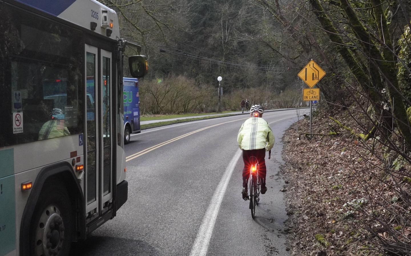
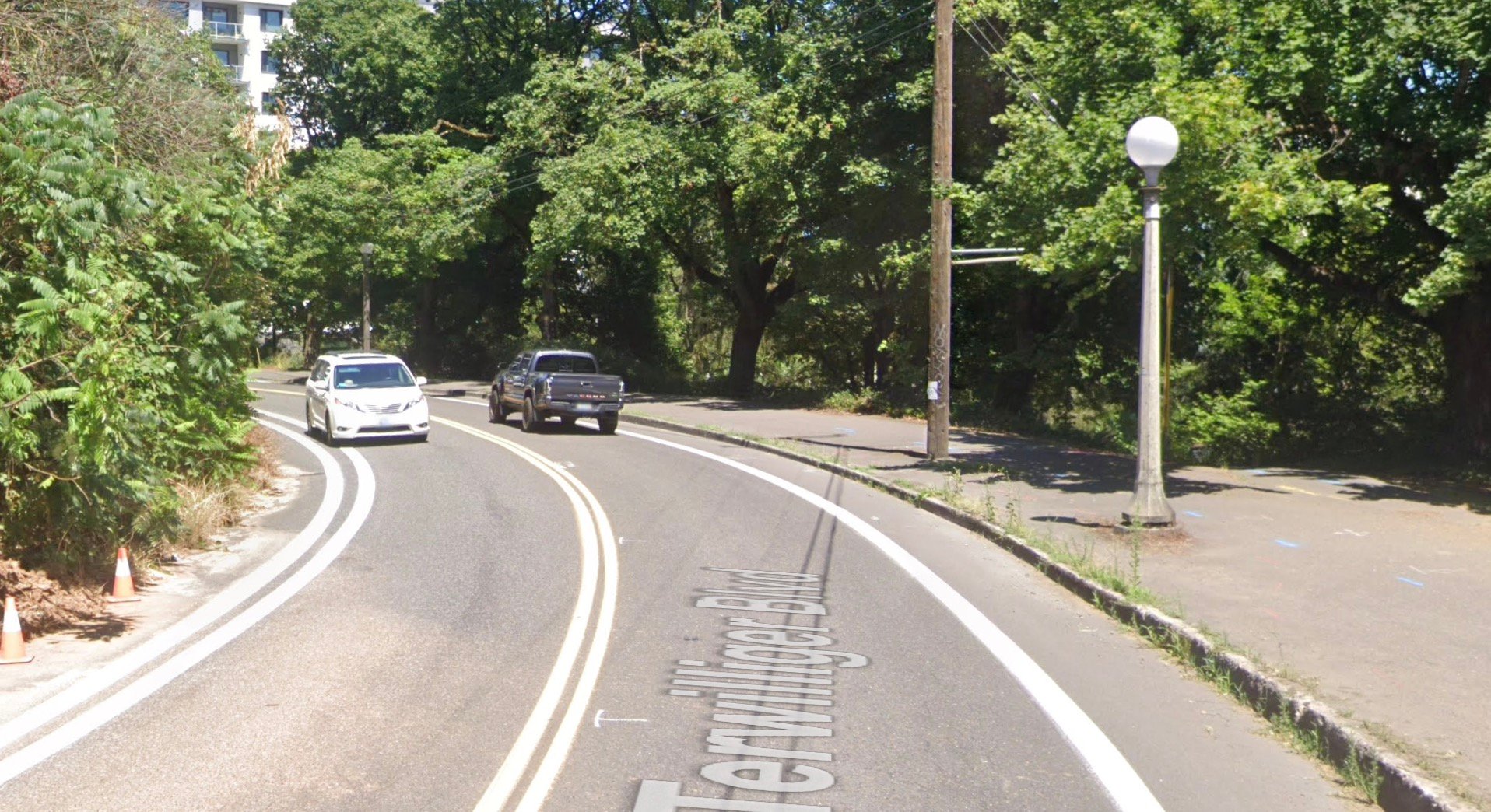
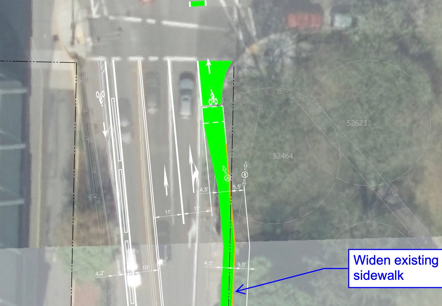
BES plans to restripe SW Terwilliger with a wider westbound (southbound, away from downtown) bike lane and add a two-foot buffer zone to separate bicycle riders from car drivers. South of SW Sheridan, there’s a curve in SW Terwilliger that is stressful for some bicycle riders to navigate and the unprotected bike lane is frequently encroached on by car users. Also as part of this project, BES would extend the westbound/southbound bike lane all the way to the intersection on SW Sam Jackson Park Road (it currently drops prior to the intersection, forcing riders to share the lane and merge in order to make a left turn at the signal).
At the SW Sam Jackson Rd intersection, bicycle users who want to turn left and stay on SW Terwilliger (the most common movement here), would roll up an ADA-compliant ramp to a new, paved waiting area at the north end of the intersection and then cross with a new bike crossing marking. The existing slip lane at the southeast corner would be removed, in order to shorten the crossing distance and provide ample width for walkers and bikers to use the corner. The Sam Jackson and Terwilliger intersection would also receive two new high-visibility crosswalks.
BES will also extend the bike lane on SW Terwillger south of the SW Sam Jackson intersection (adjacent to the gas station), to completely close the gap.
For eastbound (northbound, toward downtown) riders, BES will construct a seven-foot wide, sidewalk-level bike lane on SW Terwilliger. A bright yellow rumble strip would be installed to separate bicycle users from walkers (similar to the design on westbound Hawthorne Bridge as it approaches SW 1st).
The plan from BES is to transition this raised bike lane next to Duniway park back to street level, right where the park’s walking path comes out and just before SW Terwilliger curves toward Sheridan. Liden thinks that design is unsafe and he’d like to see the raised bike lane continue another 200-feet to the intersection with SW Sheridan.
“This, in combination with the improvements planned on SW 6th between Caruthers and Broadway and implementing the bike lane improvement at the 6th/Jackson (SWIM project BP-02), would create a very good bike route on the Terwilliger/6th corridor between downtown and Capitol Hwy!” Liden wrote in a memo to PBOT project managers back in March. “We are so tantalizingly close – can’t we get this over the finish line?”
Liden pushed PBOT to develop a plan (detail above) and cost estimate for expanding on the BES plans to provide more protection for bicycle riders in the curve on SW Terwilliger south of SW Sheridan. In response, PBOT mocked up a design that would add concrete curbs to the southbound bike lane and extend the raised bike lane to the SW Sheridan intersection. The design has been approved by PBOT’s bicycle and pedestrian coordinators.
Unfortunately, the cost would be around $476,000 (one utility pole would have to be moved) and PBOT has not committed the funding yet. According to Liden, the agency should have an update on the financial feasibility this coming fall.
The BES project will being fall of 2026. Hopefully by then, PBOT can find the money to capitalize on it and finally connect an important link in the southwest Portland bike network.


Thanks for reading.
BikePortland has served this community with independent community journalism since 2005. We rely on subscriptions from readers like you to survive. Your financial support is vital in keeping this valuable resource alive and well.
Please subscribe today to strengthen and expand our work.
Yup folks, the secret is out! In many jurisdictions, the way we get good-quality bike infrastructure isn’t through our already-bankrupt transportation department, but get it paid for with federal and state sewer and water line replacement contracts that often require the “movement” and rebuilding of curbs, not to mention all the pavement and sidewalks on top of those curbs. It’s a once-in-a-century opportunity!
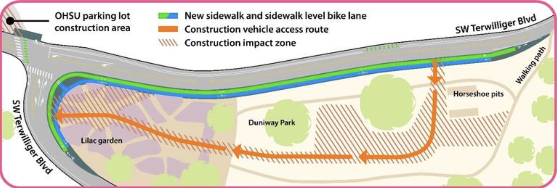
Does “Construction vehicle access route” shown on the map mean it’s for use by construction vehicles only, or by all vehicles during construction? Two very different things. I think it’s the former, since I doubt they’re building a temporary road, but you never know…
What is shown there is a temporary hauling route through Duniway Park for construction vehicles. Any street level temporary redirection of the traffic will be designed by the contractor who wins the bid and approved by PBOT prior to construction.
That needs a followup or clarification; a pole move should be less than 15K for a complex job. I assume the bulk of that figure is unrelated to that pole? If not, an explanation is on order.
Utility pole arms and the appurtenances attached to it are surprisingly expensive and require more design than you’d realize. The lights around here are also fancy as Terwilliger is classified as a historic roadway.
What this area could really use is a (downhill) Rose Lane. The buses get stuck in (car) traffic making transit riders pay a huge price and TriMet wasting operator dollars stuck in traffic. Getting the #8 out of this traffic would be a boost to ridership and help buses get moving. bikes could share this wide traffic-free lane as well.
Maybe someone at PBOT should ring up TriMet and get them to chip in a bit to make this happen
Space is pretty tight at this corner, I think regrettably what you’re proposing might not fit with a bike lane as pbot is currently proposing it. Hopefully this is much safer for bikes and peds while recognizing a perfect solution doesn’t exist here.
That’s right: he’s proposing that the Rose Lane double as a bike lane, which I think is a fantastic idea – exactly the kind of “outside the box” thinking we need nowadays.
I’m not familiar enough with the streets and ambulance routes around there to know, but it seems like a Rose Lane could possibly double as an ambulance route to bypass traffic jams.
At the Transportation & Infrastructure meeting yesterday, I thought I heard someone mention that Public Works CIP projects (Water, BES & PBOT) should/would be merged together in the near future…
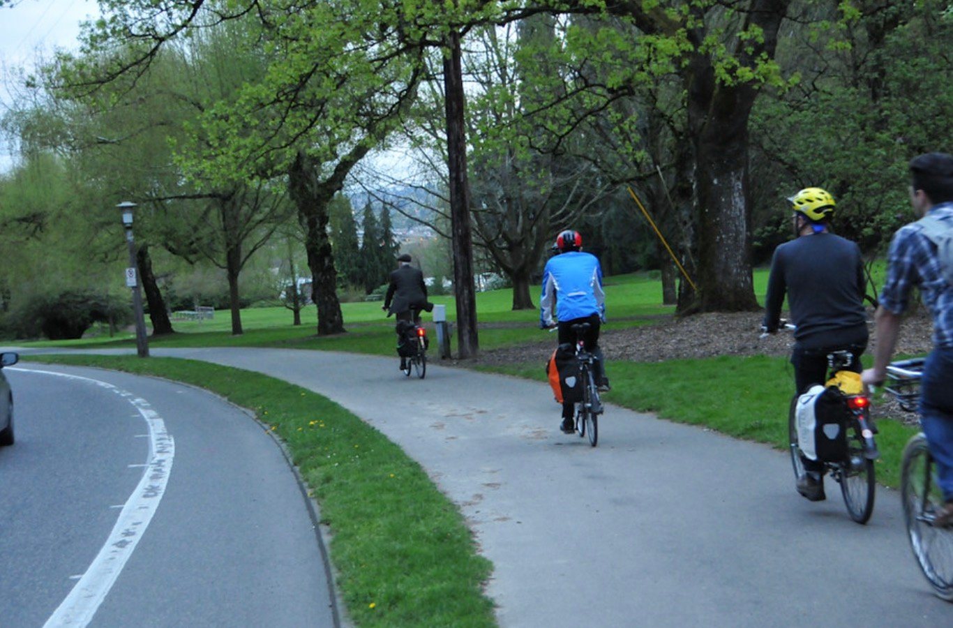
I appreciate Jonathan’s excellent coverage, as usual, but I want to note that I take issue with the characterization of the existing northbound facility in Duniway Park as a “sidewalk”, when it is in fact the northern terminus of a multi-use path and regional trail that starts several miles to the south in Lake Oswego (albeit with a significant gap in the middle, from Boones Fy Rd to just north of Barbur).
This existing facility is distinct from a sidewalk in several respects: 1) sidewalks tend to be concrete with expansion joints that are annoying for bicyclists, while paths, including this one, are joint-free asphalt. 2) Standard Portland sidewalks are 6 feet wide, while this path, a.k.a., the Terwilliger Regional Trail, is the standard 12 feet wide. 3) Sidewalks are not designed to accommodate people on bikes while multi-use paths are “8 to 80” off-street bike facilities. 4) The Terwilliger Regional Trail, like most multi-use paths, deviates from the road right-of-way and into the adjacent park property, allowing it to meander in and out of trees and away from car traffic.
The existing multi-use path, a.k.a., the Terwilliger Regional Trail, accommodates bidirectional bike and ped travel . I worry that this new design will only accommodate northbound bike travel, forcing southbound bike riders to use the bike lane on the other side of the street, which is not an 8 to 80 facility.
Could someone please clarify this point? Will southbound bicyclists still be able to use the Terwilliger Trail in Duniway Park?
Thank you, Jonathan, for your ongoing coverage of improvements to Portland’s bike network.
The intent is that you still use the southbound bike lane on Terwilliger as the multi use path is one way to the north. PBOT is redoing the road here and there will be a wider southbound bike lane that no longer has the dangerous pinch point at the intersection of Sam Jackson and Terwilliger and instead has a signalized bike crossing. I’m probably not doing the design justice with my explanation but it will be much safer.
I hate signalized bike crossings! They treat all cyclists like 8-year-olds.
I much prefer to merge with cars into the left-turn lane and I hope this new design doesn’t prevent me from doing so.
You can still do that if you want
What’s going to stop them if they use it now?
What I want to know is how is an “8 to 80” rider heading southbound (west/away from downtown) supposed to get onto the multiuse path? Any feasible route is at least as hairy as just using the bike lane on the other side of the street up to the Sam Jackson intersection and turning left, like everybody does now. This may not be an 8 to 80 facility, but it gets you (relatively safely) onto the Terwilliger bike lane.
Super excited to see these improvements.
Does this mean the left turn (confusingly…from Terwilliger continuing onto Terwilliger) would box the intersection? That might mean waiting for two green signals
Yep – that’s what it sounds like. I have to say that I object to this kind of infantilzation of cyclists. If you want a dedicated signal, ride on the sidewalk and press the crosswalk buttons. It’s completely legal to ride on the sidewalk here.
re David Hampsten’s note…Portland’s BES projects are almost entirely funded by local rate payers, not state or federal dollars. The Billion $ big pipe projects were funded locally; we pay off those bonds every month in our water/stormwater/sewer bills.
You are right, most of the funding is local, but it isn’t from parking revenue, gas taxes, vehicle registrations and other shrinking PBOT revenue. Often such sewer (and water) projects keep getting delayed until the feds or state offer some funding (ARPA during the pandemic for example) to spur local governments into doing a project sooner rather than waiting decades to do it, but as you say, a majority of the funding is still local. What is important is that one), the curbs are being moved for updated sewers, making it much cheaper to add sidewalks, widen existing sidewalks, add that bit of median-protected bike lane we’ve all been waiting for, and alas that extra right-hand turn that drivers have been begging for, and two), it’s all pretty much zero expense for PBOT, yet they get a share of the credit.
On most PBOT annual budgets, BES projects make up 25% to 40% of the overall PBOT budget, with sewer cleaning and maintenance topping the list on certain years and capitol projects like this one on other leaner years – BES and PBOT traditionally share their maintenance crews. Water has their own crews.
I ride this route often, in both directions. When going southbound, I make a vehicle-style left turn at the Sam Jackson Road intersection. I would not make use of the new “ ADA-compliant ramp [and] new, paved waiting area at the north end of the intersection [and] new bike crossing marking” because it will be inconvenient. As another commenter pointed, out that involves two green lights. These new facilities may be helpful for inexperienced riders, but PBOT/BES please also make sure that the design works for experienced bicyclists. This intersection probably has more experienced than inexperienced riders.
The northbound design seems positively dangerous. The raised bike path will drop cyclists back into the main traffic flow. The speed difference between cars and bicycles will create a merging challenge for drivers and bicyclists. Drivers likely will be surprised by bicycles entering their lane from the right. And cyclists will have to look behind themselves to judge when to enter the main road.
I, too, will continue to make the normal left turn going south at Sam Jackson, but I don’t see an issue with constructing a waiting area on the right side for people that want wait for a signal. As for the north-going path, it looks to me like there is no “merge” with the car lane all the way to the intersection with Sheridan. There is the typical right hook interaction at Sheridan. IIRC, the current bike lane merges into the right turn only car lane at this intersection, so I don’t think the new design will be worse than what it there now.
RIP to some great Lilacs.