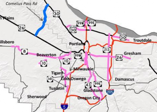
(Image: ODOT testimony on SB 117.)
Barbur Boulevard, Powell Boulevard, Tualatin Valley Highway, Lombard Street, 82nd Avenue and Macadam Avenue could all be lined up for gradual transfer from state to city control under a bill before Oregon’s legislature.
Senate Bill 117, which got its first public hearing Monday, would assign a 12-person task force to complete a draft report by the end of 2015 for prioritizing which so-called “orphan highways” within city limits for the state to upgrade and transfer to local control.
As we reported in November, state legislators, the Oregon Department of Transportation, Metro and a broad-based group of transportation advocates have endorsed a 1-cent gas tax hike that would be dedicated entirely to improving orphan highways to the point where cities would be willing to take them off ODOT’s hands.
Advertisement
Moving streets from state to city control has long been a goal of neighborhood and safety advocates. The 1999 transfer of Sandy and Martin Luther King boulevards from state to city control led to changes such as a streetcar on MLK, extensive crossing improvements on Sandy and within a few years, substantial new business investment along both streets.
More recently, ODOT has been considering requiring rural-style 12-foot-wide travel lanes on Southwest Barbur even if a federally funded bus or rail line converts it to a dramatically more urban-feeling street. That’s the sort of position that the City of Portland is seen as less likely to push for.
This stretch of outer Southwest Barbur, however, seems to be absent from ODOT’s map of transfer candidates, as does Southeast McLoughlin Boulevard. The inner wooded stretch of Southwest Barbur seems to be marked for transfer.
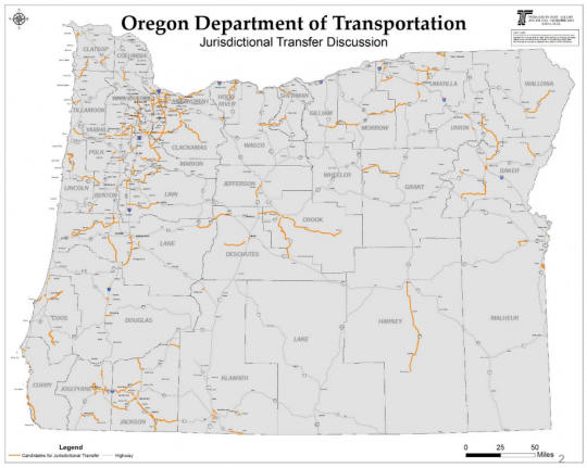
ODOT’s testimony packet also included several other local detail maps in urban areas, plus a map of possible transfer candidates statewide:
SB 117, which would have minimal fiscal impact in itself, is looking strong based on its top-tier sponsors: Sen. Michael Dembrow, D-Portland; Rep. Tobias Read, D-Beaverton; and Business and Transportation Committee Chair Sen. Lee Beyer, D-Springfield. But there’s been no formal movement in the legislature yet on the transportation funding bill that might include the proposed 1-cent gas tax on which this list hinges. The legislative session began last month and will continue through July.
— Read more of our 2015 legislative session coverage here.


Thanks for reading.
BikePortland has served this community with independent community journalism since 2005. We rely on subscriptions from readers like you to survive. Your financial support is vital in keeping this valuable resource alive and well.
Please subscribe today to strengthen and expand our work.
Does anyone know why they aren’t including NE Lombard between MLK and I-205 in this proposal?
Likely because they want to maintain it as a freight route.
I was disappointed to see Lombard West of I5 not on the list. As I understand the big obstacle to moving the freight route to Columbia is a couple of bridges that are too low. Hopefully soon we can raise those bridges and transform Lombard into something much nicer for the city of Portland.
BH Highway needs a huge overhaul. It has lots of debris in the bike lanes and it even has floating bike lanes by Jesuit High School.
Really a no brainer to turn Lombard into something similar to Foster’s planned road diet (particularly from Interstate West. Traffic numbers might be similar to Foster as well. Here’s an old bikeportland story on this idea proposed by a group of PSU students.
http://bikeportland.org/2013/04/29/planning-effort-seeks-a-re-imagined-north-lombard-street-84126
Hopefully Lombard can be one of the first. Any idea on timeline for this change of hands?
There is a concern in East Portland that ODOT and Metro want to make outer Division from 82nd to 175th (Gresham/Portland city line) the designated “US 26” and remove it from outer Powell, as part of the IPOD project (i.e. a blue line on the map). This has ramifications for Federal project funding on outer Powell.
On the plus side, when PBOT built Cully Blvd, the cost was about $7 million per mile for all the infrastructure, including acquiring right-of-way, building the sidewalks, bioswales, cycletracks, and roadway. The ODOT estimate to do much the same on outer Powell, based upon the Conceptual design, has been over $16 million per mile. Transferring jurisdiction may, in itself, cut those costs in half.
Oh come on now, the city doesn’t pay for sidewalks…..(<sarcasm maybe???)
The city didn’t acquire right of way for Cully. the 100 feet was already there.
Trading these streets for Cornelius Pass Road is a pretty big swap. Give the state CPR, but only if you want to revive the Westside Bypass.
I’ve heard this assumption from several people and it certainly sounds plausible. I asked Sen. Betsy Johnson about it last year; CP Road is in her district and she’s been a major force on transportation issues.
She told me the transfer to ODOT is her idea. She said ODOT doesn’t actually want CP Road because “the maintenance is unbelievable” and that in fact ODOT Director Matt Garrett had tried to persuade her not to make them take it. She says that she wants them to have it, however, because she feels the road needs safety upgrades throughout and ODOT has more money than the counties to make them.
“Corny Pass was never designed to handle the volume of traffic that it’s handling, and it’s just pounding the shit out of that road,” she said. “That road is owned half by Washington County, half by Multnomah County, and it is the least of anybody’s priorities.”
She said there’s no possibility that the route could be used as a westside freeway because it’s too hilly.
I’m not sure if we can take her comments at face value, but Johnson has never struck me as poorly informed.
I’m not the greatest authority on that road, but based on one unpleasant descent of CPR, I found it a nightmarish, busy road, and pedaled far too much to consider it profoundly hilly. As long as I5 still reaches California, it would be impressive if geography is the greatest obstacle to a freeway there.
Let’s take her at her word and assume that’s the case, though. Then remember that US30 and US26 aren’t technically freeways either.
Make Intel pay. It’s all their employees driving on it. Maybe they could spend some of their multi-hundred million dollar tax break on the road.
And they can stop complaining about the traffic on 26 causing late shipments to/from PDX.
I’m not a fan of Sen. Johnson, but I can sort of see her point: if neither county is taking care of it, perhaps it does need to be under State control. I worry a little that “safety improvements” will allow/encourage motor vehicle traffic to go faster, though.
Well, her using the phrase “just pounding the shit out of that road” makes me a little bit of a fan.
CPR is a freight movement issue.
In the few times that I have had loads that moved in this area (west side Metro area) CPR would have been a preferable route based on distance alone.
Add in less traffic snarls than the 405 downtown “alternative” and even a 30 mph limit on the whole segment in blue makes it look acceptable to me driving a big truck.
As it is I’ve seen trucks shortcutting through there I assume illegally.
Thanks for discussing Cornelius Pass, y’all. Be interesting to see what state control would mean for this road. It needs lots of help, not sure I believe ODOT will help anything in general, but I guess from the comments it makes sense. Looking forward to seeing it play out.
Not illegal. CPR is used by Intel as well to move product to sorting facilities at the airport, for trucking to LA or SEA for flight to international customers. The CPR route is more predictable than 26/405/84.
But what are the weight and length restrictions?
This is easy enough to find in ODOT’S official website for the state but at the county and city level it is near impossible to find official guidance until I drive my truck straight in to somewhere I’m not allowed to be.
It would be nice if Metro proper had a unified truck route map that covered all 3 counties in the UGB and did so in a consistent, thorough and precise manner.
As it is truck drivers are left to guess unless they know an old timer AND assuming the law/road classification hasn’t downgraded.
So many awesome bills coming out of Salem this year. I’m looking forward to thanking the representatives that are working so hard for us.
Thank everyone who voted for Democrats while you’re going about thanking people.
We need to put Sandy on a road diet and upzone everything from Burnside to 82nd. That’s a density corridor that should have no surface lots. The new walgreens across from the Safeway near 60th is absurd! Why all the fucking surface parking?
If you goto 82nd might as well go to the cluster !@#$ of 205 and 30. It’s only a couple blocks, and then it’d at least intersect the 205 path.
I’d look forward to the Portland transfers since PBOT seems more likely to prioritize safety over speed.
The transfer of TV HWY and Cornelius Pass are both somewhat concerning.
In the first case because local control might actually make it more of a mess than if ODOT keeps it (Don Odermott, the transportation engineer for Hillsboro, has wanted to widen it to seven lanes for years).
In the second case, I’d wonder if WashCo is pushing CornPass to the state because WashCo alone can’t afford to make it as bad as they’d like (they’ve made it pretty bad closer to Hillsboro at Hillsboro’s insistence IIRC).
This is all just speculation since I haven’t been following this closely lately, but I hope BikePortland keeps an eye on them! (Thanks!)
I used to ride Cornelius Pass, over 20 years ago. I remember when the top hairpin improvements went in. Not now. I don’t even like to DRIVE on that road. It does seem to be the main freight route over the hills, because all the other ones are steeper.
Like many of us, I’d like TV Hwy, to have consistent cycling facilities. It is really disconcerting to turn left out of Freddies, and have the bike lane just… vanish. Only to return, if only as a shoulder PAST the really congested traffic part.
Would the route markers & designations stay in place? In much of New England (and in VA too), there’s a long standing practice in which cities, counties or townships maintain route markers & guide signs for the state as long as they’re in locations required by state DOT and adhere to common practice. As a result there are a lot of old US and state markers still in use across that area (the old cutout US 3 markers in Cambridge, MA, and the numerous state markers still in use in Maine, VT, & NH, for example). Keeping the signs up on US 26 and OR 99w/99E, for example, for route continuity purposes would make sense. In VA, the local jurisdictions often put up cutout state & US markers in areas they control. These look great and are often easier to read than the Federally mandated designs. Imagine Portland putting up old style OR 99w markers on Barbur Blvd., for instance.
As for Cornelius Pass, something does need to be done out there, but does it really need to be a state highway? There does need to be a vast improvement on ped/bike facilities on Barbur/Pacific Hwy between Tigard and Terwilliger. (And 99w outbound to down-valley points, too.) One spot that really needs help is Capitol Hwy/Barbur. The X-walk across 99w is the longest in town. You couldn’t pay me to cross that! Ped bridge/tunnel is a real must have there!
That crosswalk on Barbur by the new Walgreens is intimidating.