(Photo by J. Maus/BikePortland)
The second week of February (9-13) will be Southwest Portland Week here on BikePortland.
That entire week, News Editor Michael Andersen and I will be stationed in a secret bunker (probably a pub or coffee shop in Multnomah Village) where we’ll focus our editorial output on the issues, projects, businesses, and people of southwest Portland.
If you recall our East Portland Week last summer, you’ll have some idea of what to expect. The basic idea with these focused coverage events is to open our eyes to places that we don’t cover — or physically inhabit — as often as we’d like to. Sure, we have sources all over the region and we can cover places we never visit; but it’s just the not the same as being there.
Being in a new part of the city opens us up to new perspectives and it makes our reporting better. We learned a lot about East Portland that not only influenced the 10 stories we published that week, but that still permeates our work today. We hope to do the same in southwest Portland.
And it’s a good time to be headed out that way.
Advertisement
From an infrastructure perspective, the issue of whether or not the state will tame SW Barbur Blvd recently took an interesting turn. Meanwhile, a few streets over, the City of Portland recently installed a new protected bike lane.
Some of our coverage will surely focus on the many amazing volunteer advocates this part of the city has produced. Names like Don Baack, Roger Averbeck, Marianne Fitzgerald, Keith Liden, and many others all hail from southwest Portland and have their fingerprints all over its active transportation ecosystem. Another person we hope to talk with during Southwest Portland Week is City Commissioner Steve Novick. He not only lives in the area, he’s also in charge of the Bureau of Transportation. And of course we’ll be seeking out regular, everyday bike riders too. Any southwest readers out there feel like being the subject of a Ride Along?
And what about bike businesses in southwest? Did you know that Western Bikeworks is opening a huge new store in Tigard? We’ll get the full scoop next month.
If you have ideas on stories we should cover, places we should visit, or people we should talk to while we’re in southwest Portland, please drop us a line.
UPDATE: Be sure to join us Friday afternoon for a Get Together and social hour at the Lucky Labrador Public House in Multnomah Village (7675 SW Capitol Hwy) from 4:00 – 6:30pm. We’ll meet up to chat with friends old and new, recap the week’s coverage and talk all things SW biking! (Find us upstairs)


Thanks for reading.
BikePortland has served this community with independent community journalism since 2005. We rely on subscriptions from readers like you to survive. Your financial support is vital in keeping this valuable resource alive and well.
Please subscribe today to strengthen and expand our work.
Lewis and Clark (you could check out the bike room that I helped build 5 years ago!), PCC (did you know they have a bike coordinator?), and there is always a warm chair waiting for both you guys at the bike valet. The Barbur transit center would be interesting to look more closely at. Also looking at how population growth might change SW. There is a new bike shop across from Market of Choice started by a father and son. How transportation effects the large somali immigrant population living next to barbur.
Burlingame Bikes has great service.
Thanks guys,
I definitely plan on visiting Burlingame Bikes. Saw them hanging a new sign today… getting ready for an expansion in that same building.
Not an exaggeration that we moved to this neighborhood 12 years ago for the bike commute (Terwilliger blvd) — my favorite line is “my commute is a bike ride through the forest”
Please cover the bad situations on SW 45th Ave corridor from SW Taylor’s Ferry Road all the way to BH Highway. Trails are there, but where are the bike lanes? SW Cameron Road and SW Vermont Street need overhauls, perhaps minor cycle tracks. SW Shattuck Road has seen numerous crashes since last summer.
Please cover the new bike lanes on the way for SW Oleson Road in the Raleigh Hills neighborhood.
Shattuck is an absolute death-trap. 🙁
i always thought it wasn’t too bad (at least heading North from BHH), but I have a pretty high tolerance for traffic.
SW Shattuck Road is very bad. SW Trails has worked to make trails to and from it, though.
There have been numerous crashes on SW Shattuck Road since last summer and part of it is in unincorporated Multnomah County between SW Windsor Court and SW Patton Road. I think ODOT has plans to remove one westbound turn lane on BH Highway that travels north on Shattuck. The crosswalk at BH Highway is very big and one pedestrian died there in December 2012.
Are you sure that’s unincorporated? I lived further west of there on BHH and I”m pretty sure we were technically in Portland.
Looks like you’re right, there is a little sliver in there. https://www.portlandoregon.gov/bps/article/51672
Weird.
Yes, the area where SW Scholls Ferry Road meets SW Patton Road is unincorporated Multnomah County. The line twists and turns. I’ve seen some bicyclists travel downhill on Scholls Ferry this winter by Raab Road and Patton.
I’m looking forward to this! When I moved to Multnomah Village last summer (after living in Tigard for a year) everyone told me it was a great neighborhood with the exception of biking (too many hills, narrow roads, etc) – however after becoming a full-time bike commuter in August, I have to say I love biking in SW! Sure, I am envious of the sense of community and biking culture elsewhere in the city, but I have a lovely 20-25 minute commute to my office in northeast Tigard every day and I also enjoy biking to nearby Mult Village, Maple wood coffee, Capitol Hill library, and Barbur foods (among others).
True, but where are the bike lanes, or even shoulders, on SW Vermont Street and SW Garden Home Road west of SW 45th Ave?
Please update readers on the bike/ped improvements along Multnomah Blvd now that the construction is complete as well as the ongoing safety issues along Capitol Highway from Multnomah Village to Taylors Ferry Rd.
That section of SW Captiol Highway is horrible in rush hour with rain storms.
It is very nice to have more separated bike and pedestrian traffic on Multnomah Blvd east of SW 40th Ave. West of 40th is a different story.
Hi Moses,
I rode that section of Capitol Hwy today with local activist Roger Averbeck. Look for a story soon. Thanks for the suggestion.
The connections between SW Portland and Washington County need a lot of work. For example, there are bike lanes all the way down Multnomah Blvd and Garden Home Rd. to Oleson Rd., but then the lanes soon disappear on Garden Home. My wife sometimes rides between Multnomah Village and the elementary school where she teaches on School’s Ferry in Beaverton, and riding Garden Home west of Oleson requires her to duke it out on a very narrow road with lots of fast-moving car traffic. She’d ride a lot more if she felt safer there. Beaverton Hillsdale Highway also features disappearing bike lanes after one leaves Portland, making for a dangerous and unpleasant ride into Beaverton.
The bike lanes on BH Highway actually stop / start in roughly the 67th block of the city, right by the new Shoe Store on BH Highway, about 260 feet east of where SW Oleson Road meets BH Highway.
Which is the city (and county) boundary.
The city and the county boundary is at SW 65th Ave regarding SW Beaverton-Hillsdale Highway. The speed limit on that state highway is 35 mph from at least Highway 217 until the county line when it becomes 40 mph.
Washington County has plans to fix that horrible intersection in stages, but it surely needs to become more pedestrian and bike-friendly.
http://www.fixbhos.org/
Go to Baker & Spice in Hilsdale!!! Best pastries ever…seriously! Don’t F#&! up this chance to enjoy some of the best eats in all of Portland. I’m partial to the savory scone.
TasteBud pizza plans to open soon in Multnomah Village. more bike parking has been installed in the village lately.
I’d like to hear if there are any prospects for improving the Willamette riverside path between Johns Landing and the South Waterfront, especially that miserable part where you have to go on a tiny sidewalk between the River Forum office complex and the Benz Spring Company.
Isn’t most of that area private property?
YES. That area is COMPLETELY RIDICULOUS.
Lewis and clark law school(outstanding bike parking), burlingame bikes, palatine hill rd (during rush hr reminds me of amsterdam), tryon creek state park, sw terwilliger (great views), riverview cemetary = crucial link, sellwood construction, virginia bike boulevard.
Would be great to see a People on Bikes feature for Sellwood Bridge users and/or Riverview Cemetery users. Either now, or later this spring. Many, many riders successfully navigating the construction area and/or using the cemetery. Despite the narrowness, the bridge feels safer than the super-busy Hawthorne, partly due to the forced sharing involved when using it.
They had one over the Sellwood Bridge from last year:
http://bikeportland.org/2014/05/21/ride-along-with-the-mcleod-family-sellwood-to-lair-hill-106285
That’s a Ride Along story, not a People on Bikes story.
http://bikeportland.org/tag/people-on-bikes
http://bikeportland.org/tag/ride-along
I would love to see your thoughts on the improvements that could be made in the Hillsdale center area. The sad triangle on the western end, where Capitol Hwy & BHH & Bertha all meet up by Sasquatch – is a rather stressful section when I bike westbound thru there with my kids along Capitol Hwy. Eastbount isn’t bad though.
Everyone’s excited about the new development going in right there on north side of Capitol which I assume will have an affect on traffic patterns – hopefully there’s some plans to improve the bikeability of that zone?
Also further west on Capitol, where it veers off from Vermont, by Fryer Tuck – that’s another stressful section with the kids.
PS – welcome to hill country, don’t bring your 3 speed 😉
The city will start building a ped/bike bridge from “little” Bertha (the one parallel to B-H Hwy) to Sasquatch Brewery crossing the Fanno Creek Headquartes hopefully this year. It is part of the Red Electric Trail. That will help to avoid the death trap that is the B-H Hwy -Bertha interesection.
Do you guys ever go to east Portland? I don’t mean just to 82nd…I mean like 102nd, 122nd, Parkrose/Gateway, and beyond. Not too bike friendly out there. Drivers seem pretty aggressive towards cyclists.
That’s exactly what they did last summer. Click on the link they have above.
Looking forward to your reports! I first got on a bike on the 3500 block of SW Hume Street…still unpaved, still quiet. In the late 50’s and into the early 60’s I biked to Multnomah, to Hillsdale and the swimming pool at Wilson HS, to Lewis & Clark college where my dad taught. We found low traffic routes with some busy stretches, but I was only hit once…riding on the sidewalk up 35th into what is now called “The Village.” We think sidewalks can be safer, but a guy in a pick up making a left onto Moss, did see me at all until he wacked me pretty good! Scrapes and bruises was all I got…missed a few ball games.
I might be interested in a ride along… Some good stuff going on out here in Washington county… (and some not so good)
Curious, what were your views on what was taking place in Washington County? I don’t like the 2 lanes into a wider 4 lane road of Bethany Blvd, north of Highway 26.
Sorry, can’t reply to that. I moved to Sherwood, so my range has become much more limited.
Bike lanes should have been incorporated into the recent overhaul of downtown Tigard. Tigard has made a new boardwalk on SW Johnson Street over Derry Dell Creek, though.
1) Bring a radar gun and measure traffic speeds on B-H Hwy.
2) Attempt to turn L across B-H Hwy during nighttime rush hour in the winter in the rain.
3) Check out the meager bike parking facilities for the major grocery stores along B-H Hwy (Albertson’s, FM, Safeway).
4) Go west on B-H into Wash Cnty. Be prepared to pucker up.
5) Check out the bike lane and sidewalk improvements on Vermont St near 30th. They’re great.
6) Major N-S streets from Vermont north to Council Crest are universally narrow and scary. Luckily piecemealing the neighborhood streets works Ok due to generally low volume of car traffic. Definitely bring your gears.
7) Grab lunch at the Village Hut.
Fred Meyer has a couple bike parking spots on SW 76th Ave in Raleigh Hills. The whole store needs another entrance/exit.
As the comments suggest, you need to expand your perspective beyond Multnomah Village, and include the issues around pedestrian travel as well. Ge off your bikes and walk on some of our streets. Capitol hwy east of Hillsdale, Capitol Hwy at Vermont/30th we call the “Hoot owl Corner”, walking on Beaverton Hillsdale Hwy, especially if you are a child going to Robert Gray and live on SW 30th or west of there.
Examine why we located the SWTrail routes where we did. Explain why we have 20 mph speed limits for bikes, but where we have a marked pedestrian route for walkers on similar streets, we do not have the same protections afforded us by the CITY THAT WORKS!
I will be happy to take you for a walk. Others will join us.
Welcome to SW PORTLAND where 15% of our streets have sidewalks, where the city constantly issues waivers rather than requiring developers to install sidewalks, where 42% of our ARTERIALS ie Barbur, Dosch Road, B-H Hwy Marquam Hill Road do not have sidewalks, and in many cases do not have bike lanes.
Check out how many routes we have to get north from any part of SW to downtown that have sidewalks, bike lanes!
We have been working for years to get the city to use less expensive solutions to get high safety returns. For example, a 2011 study of putting sidewalks and bike lanes on both sides AND DOING THE STORMWATER AS THE STORMWATER PLAN SPECIFIED (half the cost) $21.7 million per mile . In 2013, the City built 5 stretches of sidewalk on one side of the street in SW at an average cost of $3 million per mile, and one project, Maplewood with an extended 4 ft wide shoulder with no parking posted at a cost of 0.5 million per mile. Federal Highway studies have shown that the extended shoulders provided 80% of the safety benefits of having a full sidewalk.
An extended shoulder combination two way pedestrian route and climbing bike lane is what SWTrails has been fighting for on some of our narrow steep streets, like Dosch and Marquam Hi@@ Road. Serves both needs and is economical(but not inexpensive). We need to be sure our TSP planners, the Planning and Sustainability Commission and City Council understand these needs and other reasonable but non standard solutions.
We look forward to discussing some of these ideas as we walk.
Don Baack.
For the new Comprehensive Plan the highest intensity development is planned for the only “Town Center” in SW at the intersection of SW Capitol and Barbur. Activating that area will probably take removing freeway ramps. It would be great to hear what else would need to be done to make it accessible/attractive by bike.
The Hillsdale intersection of Capitol and Barbur is in a delicate area with big hills and many creeks. Light rail won’t make it attractive for biking and walking. Captiol needs cycle-track styled multiuse paths. The future Red Electric Trail will help walking and biking. The comprehensive plan identifies the Raleigh Hills (town cente) in nearby Washington County as a true town center with nearby parks, independent Parr Lumber lumber yard, grocery stores, busy bus lines, and a new Fanno Creek bridge. Rezoning the nearby Portland streets like SW Hamilton Street and SW Seymour for huge development isn’t wanted. Small mom-and-pop deli stores are needed over massive structures near SW Scholls Ferry Road.
Jonathan,
I am looking forward to your reports as well because honestly SW has so much potential for strong infrastructure with more available space to expand on. yet it is the least cycling friendly part of Portland since most roads (with bike lanes) are high speed blvds that I wouldn’t wish on my worst enemy.
I would also suggest taking a leisurely ride up barbur (south bound) and hanging a right onto Capitol hwy (from the Green box) if your wits survive that, then hang a right onto Sunset Blvd and enjoy the 1000 ft bike lane that ends abruptly into a pinch point at the top of a hill (where bike riders are riding the slowest) then enjoy the 25 mph curvy and beautiful tree lined rest of the ride where you’ll be passed multiple times on narrow completely blind curves by drivers that feel like your life doesn’t matter… but that extra 5 mph sure does!
Oh and enjoy trying to Get to Multnomah village un-frazzled since there is only one road that has a bike lane (Multnomah Blvd) and coming from your direction will take an extra half hour or so to get to and enjoy the pleasure of another 1000 ft bike lane that ends abruptly.
Welcome to SW Portland our moto is “We may be part of America’s #4 most bike friendly city but we’re trying hard to end that all together!”
“Don’t come back now, ya hear!”
Parts of Capitol Highway have floating bike lanes and floating sidewalks. Many from SW Trails and SWNI led PBOT and BES to overhaul SW Maplewood Road for 1/5 of the cost of most PBOT sidewalk installations.
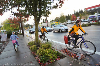
I find it amusing that the picture you show has a kid on the sidewalk because the bike lane is so narrow and has no protection. And yet, not being from Portland, that is one of the better streets for bike infrastructure in SW Portland and the city is probably even slightly proud of it.
That is the Hillsdale Town Center on SW Captiol Highway, TriMet bus stops can create blocked bikes, and I’m wanting to see the future pedestrian / bike infrastructure on the new bank in the NW side of the town center on SW Capitol Highway. It currently has plywood on the side under construction. Neighborhood leaders lead a charge to put in a lower 25 mph speed limit on that photographed section.
Just want to thank everyone for all the suggestions. It’s been a great 3 days out here so far and we’ve got 2 more left. (But remember, we’ll always cover SW Portland– not just this week!).