After sitting on ice for a year while the city waited out high construction costs, Portland’s north-south 50s Bikeway is alive and moving forward.
The 4.3-mile, $1.5 million route down Portland’s middle east side, which was delayed last August, is likely to start construction in late March and wrap up by late July, the project manager said Wednesday.
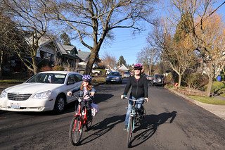
When finished, it’ll stretch from the Alameda Ridge south to Woodstock Street along 53rd and 52nd avenues (PDF), connecting the Rose City Park, North Tabor, Mt. Tabor, South Tabor, Richmond, Creston-Kenilworth and Woodstock neighborhoods, which include 20,000 residents and 12 schools. North of Division, it’ll be a neighborhood greenway marked with sharrows and directional signs; south of Division, a pair of 6-foot painted bike lanes on either side of the street.
Diverters will block northbound and southbound auto traffic onto 53rd at Burnside. Further south at 52nd and Division, signs will forbid northbound auto traffic, but because TriMet’s #71 bus needs to continue northward there, there won’t be a physical obstacle to block cars.
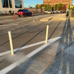
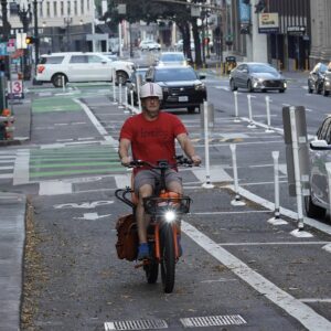
South of Division, one auto parking lane will be removed from the east side of 52nd to make room for the painted bike lanes. On the west side of 52nd, the bike lane will run alongside parked cars.
A planned neighborhood greenway that weaves an alternative route into the neighborhoods east of Southeast 52nd hasn’t yet been funded and won’t be built this year.
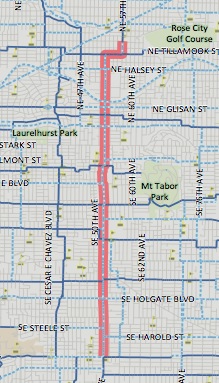
Much of the project’s cost will go to improve crossings of major streets, including a new HAWK beacon at Burnside and 53rd, a median element at Stark, curb extensions at Belmont and Lincoln and a rapid-flash beacon (PDF) at Woodward.
The city’s transportation bureau had sidelined the federally funded project after the first round of construction bids came in more than 20 percent higher than expected. As we shared back in August, city workers estimated that this was because “the construction market has recently reached saturation” for the year. In an interview Wednesday, Project Manager Rich Newlands said the second round of bidding seemed to have confirmed the city’s hunch: this time two of the eight bids, he said, had come in below the original projection.
Some people who live near the project have expressed concern about auto traffic diverting onto nearby streets such as Southeast 51st, 53rd and 54th. As a condition of approval for the project, the city council ordered a 12-month test of where and how much traffic was diverting from Southeast 52nd.
Though these improvements aren’t perfect, they’re good news for neighborhoods that are becoming major destinations in their own right, with no frequent north-south public transit but more and more need for north-south travel. It’ll be nice to see this route interact with the nearby bike lanes on Southeast Division and the ones planned for Southeast Foster, sending relatively comfortable bike connections through the southern side of Portland’s all-important east-side street grid.



Thanks for reading.
BikePortland has served this community with independent community journalism since 2005. We rely on subscriptions from readers like you to survive. Your financial support is vital in keeping this valuable resource alive and well.
Please subscribe today to strengthen and expand our work.
Fantastic news. Why no bike lanes across I-84?
PBOT doesn’t like to mix bike lanes with shared lanes. While cyclist will usually move right at the wider overpasses, requiring them to do so for so short a distance, doesn’t make sense.
Currently the only improvements slated for the traffic light at Glisan are a bike box and sharrows. We want more diversion southbound but PBOT has told us that they do not want two diverters that close together. As transportation chair for North Tabor I have been working on several project around the area and believe a southbound diverter is needed south of the medical center.
That traffic light at Glisan handles over 5000 vehicles a day, over 2000 of them just from the hospital parking structure alone. At peak commute time that is 6 per minute. I do not see this stretch qualifying for the 20 MPH under current engineering and will be a point on congestion the day it is built. The overpass north should be striped with “advisory bike lanes” at least. It is a nice route, but not during commute time and I do think this plan will change any traffic patterns around the hospital.
Agreed. I bike daily on 53rd between Halsey and Burnside, and it is a farce for bicyclists. All they had to do was move the diverter one block north of 53rd, which would have still allowed traffic leaving the hospital to access Glisan.
What about all of the people that live in the neighborhood north of I-84 adjacent to 53rd? If this were parallel street I would be all for diverters. If you had one in place just north of the overpass, anyone living in that neighborhood would have to drive all the way to 47th or 60th to get over I-84.
Honestly, if I could make one improvement in this particular area, it would be to add a signal at 52nd and Glisan and force everyone leaving the hospital to access Glisan at that point. I have observed several near-misses at 53rd and Hoyt due to the queue of cars waiting to turn on Glisan and poor sight lines. This change would allow PBOT to reduce the number of lanes at 53rd and Glisan (eliminate the southbound turn lane), allowing space for bike lanes.
It is good to note that north and south of the border we are thinking alike. Always a good sign.
Is PBOT planning on reconstructing speed bumps north of Glisan to a closer spacing? The greenway retrofits do this.
No, the 95% engineering plans indicate no improvements other than sharrows and bike boxes from Halsey south to Glisan.
Long term with redevelopment Providence wants to expand. When it does, a traffic light at 52nd will have to be built. Then, the 2000+ vehicles a day will take 52nd instead and 53rd will actually become a real bikeway. Until that day comes, we will just have to have a major point of congestion. Since there are not any other crossings of the Gulch between 53rd and 60th I can not see how a diverter north of Hoyt would work. Advisory bike lanes and traffic calming yes, but we will still be at 1500 a day at least going over the bridge.
This is great news. It will make riding with my daughter to Glencoe Elementary much safer.
Yes, but until we fix Burnside there is no good way to get to Mount Tabor Middle School or Mount Tabor park without taking 60th which has way to many vehicles and terrible sidewalks. We need a crossing at 57th for the school and 62nd for the Park.
If you care, the HAWK Beacon is now officially called a pedestrian hybrid beacon. Only slightly less jargon-y, but at least it’s not trying to be a cutesy bird name.
HAWK signals still require “beg” buttons to activate. Thus, they bake into the system the inferior status of cycling in the transportation network. When do we ask drivers to stop and push a button to activate a signal?
I, for one, welcome with open arms a “demand” button that allows me to efficiently share common infrastructure. I refuse to let myself be called inferior.
“share common infrastructure”
i’m really glad to hear that motorists will also get to use these efficient “demand” buttons. i’ve always felt guilty that they were left out. 🙁
Reread my comment. We’re already all sharing the common infrastructure (i.e. roads, signals, etc.) on some level. The “demand” button gives me a way to use that more efficiently, in the same way signal loops in the road do so for motorists and sometimes bikes. Slow down, re-read.
“We’re already all sharing the common infrastructure on some level”
____
“The “demand” button gives me a way to use that more efficiently”
awesome for you!!! so when do motorists get to use these efficient buttons?
Whenever they want.
please let me know when you actually see a motorist get out of their car and press a beg button. also please let me know what is equitable about motorists and pedestrians having thousands of dedicated signals while cyclists have only a handful. cycling mode share is about the same as walking but cyclists have profoundly unequal access to signalled intersections. just because this second class infrastructure works for you does not mean there is equity.
In this case, we do NOT want motorists to use 53rd and that light. 55th has a full traffic light already next to QFC. 53rd is for bikes and pedestrians so we do NOT want to encourage more autos. 55th has a “B” rating anyway as a traffic light, so there is no need for another one so close together for autos.
Clearly this isn’t up to Copenhagen standards, so we should totally refuse that they even consider building this!
Complain all you want. I live on Burnside and am going to be happy that a) this will make crossing the street easier a lot easier and b) there will be something else that will force the drivers that think since 84 is bumper to bumper, using Burnside as a freeway is just fine.
I have been meaning to knock on your door. I have lots of data on Burnside to share with you and things are moving. Our stakeholders committee for giving Burnside a “safety modernization” has been approved by the North Tabor NA, I am speaking at Mount Tabor NA next month and Montavilla went well last week.
Every intersection that has sensors in the roadway to make the traffic lights change is, in effect, exactly that.
Not HAWK’s for cars. These specifically do NOT have auto censors as we do not want to encourage cars to use these streets. They are for locals and bikes/peds. Cars in this case should use 55th instead. They are parallel. This intersection should look like the crossing of Clinton and Caesar Chavez when done with a traffic light like the one at 41st and East Burnside.
This is great! On 52nd somewhere near Woodstock, there’s a bike lane that starts and mysteriously ends after 100 feet.
I hope that it’s eventually extended to the Springwater Trail. Also, start planning the 70s bikeway.
Hey Todd we are in luck. There already is a bike lane on 52nd south of Woodstock. 52nd T’s into Harney which also has a bike lane that will take you to the Springwater trail, meeting up at Johson Creek blvd.
I’m glad to hear I was wrong – that’s awesome that this will connect to the Springwater. I’m thinking of 72nd, which is big and wide, but has no bike lanes or signs whatsoever.
that would be the Center to Gladstone connecting bike lane just south of Foster before Holgate… I live a few blocks away and that thing drives me crazy… southbound drivers are always driving in it to avoid having to swerve left and then right within a half-block distance… I’m always worried because the law forces me to ride in it but that means I’m effectively swerving in front of the vehicles after passing the Dougy Center and then swerving out of the way of traffic after Gladstone when the bike lane ends…
i agree, it drives me nuts too. But that is what the length of 52nd will look like come this spring!
I’m still trying to figure out why the city thinks it’s a good idea to have bikes turn left towards Foster here instead of the turn lane at Foster and 52nd.
There is a similar “disappearing bike lane” on 47th between Burnside and Glisan. They’re very weird infrastructure for greenway continuity, but I guess that’s what we have for having an incomplete, kind-of grid system.
That little one on 47th was installed back in 2004 or so. I was on the Providence Good Neighbor Agreement committee at the time and suggested it since that off-set intersection was such a pain to navigate (I wanted to extend the 47th bike lanes to Stark, but that required parking removal and there is not enough ROW curb to curb). Since then urban design guidelines have changed. It is on my Long term agenda to hopefully work with the city to upgrade that off-set greenway intersection when we get money to modernize our older greenways. Personally, I think that it should be washed out and replaced with sharrows and green crosswalk striping like they are doing at the new light rail construction in SW. Green striping at the south and north ends with a middle crosswalk striping at the ADA compliant curb cut outs. The bike lanes end at Glisan coming from the north anyway, so connecting these up with Sharrows makes sense. This is an emergency response route, so speed bumps are out.
I’m super excited to get a bike lane all the way up 52nd… I ride it frequently and it’s a narrow street with underutilized parking… bike lanes will make it so I feel comfortable going on it with my kid… no more zig-zagging through the neighborhood just to feel safer…
Fabulous news, really been looking forward to it. Michael, you say toward the end that “some people who live near the project are concerned about diversion…” – I think this concern is just near Division, where thee will be a northbound auto (not bus) diverter. You might want to clarify this.
Yes, I was going to comment on this. For much of the route 52nd is either an arterial (South of Division) or a quieter neighborhood street, which I can’t imagine needing diversion. have to imagine that most people will just “divert” down to 50th at Division (which is kind of where they are supposed to be going anyway). I take this route every day, and there are a lot of cars that continue straight on 52nd until they hit Lincoln and then head left to 50th.
So what diversion are we talking about?
A painted northbound diverter on 52nd so only buses can enter. It was a 50/50 issue with the Mount Tabor NA.
So is it:
A. people who live along 52nd who are upset they won’t be able to drive through now
or
B. people who live along 51st/53rd/etc. who think traffic will now increase on their streets.
I guess I’m asking, is it the diverter or the diversion?
Traffic is already blasting along 51st and 53rd in the morning from Division to Lincoln when the lights cause back-ups. To reduce the back-ups, a west-bound right-turn lane is SUPPOSED to be put in at 50th. Real Soon Now (TM).
The PFD is opposed to physical diverters at 52nd.
Plans for the project include installing speed bumps between Lincoln and Division on 51st, 53rd, and 54th (one per block).
ftp://ftp02.portlandoregon.gov/PBOT/CDS/T00121%20-%20NE-SE%2050s%20Bikeway/Utility%20Notice%203_PLANS–Bid-Documents–10-30-13/T00121%20-%2050's%20Bikeway%20Woodstock%20Blvd–Utility%20Notice%203_PLANS–Bid-Documents–10-30-13.pdf
My understanding from talking to Rich, the project manager, is that the main concern is B.
Woohoo! Great news!
Too bad that a quarter of the route is door-zone bike lane. I probably will never ride southbound on 52nd south of Division again after the door-zone bike lanes are put in.
Do you ride it now?
I do actually! When I’m on my faster-type bike it feels like a good option to ride it sometimes – generally lower-traffic type times. I realize that I am atypical and a door-zone bike lane will almost certainly get more bike use than that side of the road gets now.
Well essentially you already are riding in a door zone now, so I don’t really think the lanes will be any worse (other than one entire side will have NO door zone). Maybe there will be a few more parked cars on the West side though. 6 foot lanes will give a decent buffer though, with probably two feet to stay outside of the door zone.
You don’t have to ride in the door zone. Just hug the white line.
The SE 19th Avenue bikeway is also showing signs of life. 20 mph signs with flags have recently been installed along several blocks in Westmoreland. Does that mean the city will soon be turning the north/south stop signs and installing diverters at relevant intersections?
Not until the traffic calming is funded.
Is a hawk signal significantly more expensive than the rapid flash beacon? The rapid flash beacons seem really inferior to the hawk signal IMHO.
HAWK (aka Hybrid Beacons) are much more expensive, basically the same cost as a full traffic signal.
Rapid flash beacons (RRFBs) work really well considering they’re just little flashing lights. The installation on Woodward will be one of the first RRFB installations intentionally designed for bicyclists to use – we’ll see how it goes.
Hybrid Beacons run about $150-$200k. RRFB cost $12k per pole, with 2 minimum on a 2-lane street, or 3 minimum on a 5 lane street. Full signals run about $250k.
What a wasted opportunity of a project. Without diversion a Halsey or Glisan, this project is worthless.
I emailed the project manager last year asking why diverters weren’t being installed at those locations , and the response I got was “We can’t, they would impede car traffic”. UMMMM… Isn’t that the entire point of a bike boulevard?
And don’t even get me started on the fact one if the diverters is nothing more than a fricking SIGN. Wow. Because motorists totally obey signs!
I see now why Portland is falling and falling in the bike league tables. With mediocrity like this, it explains everything.
I wouldn’t say worthless. What about the other 70% of the project? Some of us are quite excited for it.
I think there are issues with what exactly this project is to be (and the terminology). As it appears it is neighborhood greenway, bike way, and maybe “bike boulevard” depending on where you are. But again these are very different segments of road, spanning arterial all the way to quiet neighborhood.
How do you propose to get buses onto 52nd around Division? Or would you just like the bus line rerouted?
Why do buses need to go down 52nd in the first place? 50th would be just as good (lots of us on the East side live more than two blocks away from a bus stop). So yeah, why not re route the buses.
Over all I’m glad the project is on track, I was affraid that it’d end up forever on the plannning table.
The bus travels east/west on Lincoln to access 60th. The intersection at Division/60th has geometric issues that prevent the southbound right turn.
Interesting about 60th and Division. As part of the project they’re cutting back the SE corner of 52nd and Division, but I guess that’s just to allow cars to zoom around the corner from NB 52nd to EB Division. (plans for that intersection: http://s11.postimg.org/4ohdzlrib/52and_Div.png)
Good catch, Stevie. That’s weird. I guess you’re right about the reason but I’m not sure.
The reason we are cutting back the corner is so that shcool buses (one just up the street on Division) can make the turn on to Division with the new lane configuration that pushes the travel lane closer to the curb
Okay, that makes since. I hadn’t realized how the new configuration restricts turning movement.
Stevie, thanks for noticing this. This change to the southeast corner of 52nd and Division is doing exactly the opposite of what we should be trying to do with livable streets projects: we are increasing the corner turn radius (which increases the speed of turning cars and trucks) while at the same time increasing the pedestrian-crossing distance. This increases the risk of (higher-speed) right hooks and increases the risk to pedestrians.
What is the cost for this one corner of this one intersection? I haven’t seen any other engineering drawings for the project, but it seems plausible that this is the single most expensive piece of the project: The curb line is being relocated, which requires new roadway, a relocated stormwater inlet and new storm piping, a new traffic signal pole and arm, and a rebuilt sidewalk.
All this expense — and increased hazard for cyclists and pedestrians — because “the new lane configuration […] pushes the travel lane closer to the curb.” Couldn’t we come up with a *much* preferable solution if parking were simply eliminated on *both* sides of 52nd for the first 100 feet (or whatever) south of Division? And free up a couple hundred thousand dollars to use elsewhere in the project for something that increases safety for bikes and peds, instead of making it worse?
Well it looks as though the parking removal is already planned for both sides there. http://s23.postimg.org/jpj63qx1n/52div.png
Perhaps there could have been other alternatives though. I’m sure the cost is significant, but the project also includes a pedestrian hybrid signal, a rapid flash beacon, and other median islands and curb extensions/cuts that make it relatively small in the grand scheme of things. Plans here: ftp://ftp02.portlandoregon.gov/PBOT/CDS/T00121%20-%20NE-SE%2050s%20Bikeway/Utility%20Notice%203_PLANS–Bid-Documents–10-30-13/
The compromised pedestrian safety that seems to be planned for this intersection is worrying, but I don’t really know the different options.
The Mount Tabor NA wants the bus re-routed to Division and give up on Lincoln northbound. Tri-Met has said no.
North Tabor will be fighting for a diverter just south of the medical center/Glisan WHEN traffic volumes come in over the amount. The project manager told us no last year as they do not want to “Place two diverters that close together as it will impede auto traffic.”
Well, as a neighborhood we have constant problems with Hospital traffic parking in the neighborhood and cut-throughs coming from the north. We want the diverter….and will keep pushing. I will point this out again when our NA is briefed on this project (probably not until a bid is approved).
Sounds like a good place for a parking permit program.
This is being looked into as we speak. I suspect though, that my neighbors will say “It is not yet time, we would prefer physical diversion.” In our long term comprehensive plan letter to the city, we are calling for significant density north of Glisan. Once this comes, there will have to be permit parking…the question is whether this time has come. I think so, but I suspect my neighbors will say no and prefer physical diversion.
So is this diverter going in at 52nd and Division?
ftp://ftp02.portlandoregon.gov/PBOT/50's%20Bikeway/Final%20-%20Division%20&%2052nd.pdf
ftp://ftp02.portlandoregon.gov/PBOT/50's%20Bikeway/2012-06-06/52ndDivision%201in=20ft.pdf
nevermind… found the final plans. no physical diverter.
No protected bike lanes?
Since this is funded with federal money the plans were approved years ago and before th SW Multnomah “Experiment.” I suspect, that if it was being designed now, 52nd would have one row of parking to be used as the buffer, but the jury is still out as to whether more cyclists prefer the curb-tight bike lane with a row of cars as a buffer or this standard six foot lane in the door zone.
I don’t get the view that a door zone bike lane is worse than no bike lane at all. If you ride on or near the white line, it is almost impossible to get doored. If you also stay alert to the parked cars you are approaching, you will usually see heads in the ones that pose a dooring threat. Heads = watch out.
50 y/o, been riding in cities all my life, and have never been doored. Just two close calls.
If we insist on separated cyclepaths or nothing, in many locations we’ll get . . . nothing. That is the reality of limited budgets and competing interests. Maybe in 10 years it will be different. I’d like to get more people on bikes this decade.
I’ve tried doing that and have found that many drivers do not understand why I am not “in the bike lane.” A good number pass me quite close and a few yell at me. Rather than worrying about some aggressive driver misjudging his/her buzz of me and causing an accident, I just take other streets.
Whether a door-zone bike lane is “worse than nothing” at a societal level I don’t know. But I know that, on some streets, when door-zone bike lanes start, I divert to other streets.
6 feet is going to be pretty wide (wider than most bike lanes we have in Portland), so that will give bikes a little more space. I was riding home on Woodstock last night, and while the bike lanes there are technically in the door zone, the whole section is wide enough that I never am worried about a door. Granted Woodstock is a little abnormal because it is a pretty wide cross section and the parking lane (and bike lanes) are nice and wide. It’s definitely not as narrow as the bike/parking lanes on Duke. I am envisioning that 52nd will be a mix between the two.
Personally, 6-foot door-zone bike lanes aren’t wide enough to make me feel comfortable. I’ve tried them (on SE Hawthorne between Grand and 12th) and I prefer using side streets.
While you are riding, watch for cars pulling into a spot.
Look for someone getting into a car.
As you are riding, look at the side mirrors of the cars to see someone is in the car.
As previously stated, hug the outside of the bike lane. I don’t even hug often, but just ride further to the left.
Also, know the street/area you are traversing. If there are a lot of businesses that lend to a lot of come and go traffic like a grocery store or library, be a little more careful. For instance, when I lived in the Hollywood area, I would often avoid the streets with bike lanes or either just ride outside of them (they are really not needed there, but that is another issue) because there was so much in and out traffic and it made for a car door swinging open that much more likely. Now, compare that to E Burnside from 72nd to 82nd which is a neighborhood and cars on the streets are going to tend to sit idle for much longer. Less of a chance to get doored.
Also, educate your non bike riding friends and coworkers. I often get asked “why do you cyclists think you need to ride so far to the left of a bike lane?” And, I respond with “because people do not look before they open doors into a bike lane.” They respond “Oh, I guess that makes sense then–I never thought of it that way.”
While this is not fool proof, these things have allowed me to ride a 2-3k miles a year without a single dooring incident.
Good ideas and thank you for the advice. Personally, I prefer to not deal with the cognitive burden of looking into each car for heads. I’d rather just ride on streets where I’m not directed to ride in the door zone. I’m glad door-zone riding works well enough for you though!
That little stub of bike lane is to connect Gladstone to Center. It’s actually kind of handy for West to East travel.
It’s been almost 20 years! This project was first proposed in the 1996 Bicycle Master Plan. It was listed as a Priority 2 project, meaning those projects that would be completed in 5-10 years. So it was supposed to be complete by 2006. Though it was projected to only cost $130K, it was supposed to make it as far south as Harney Dr, spitting distance to the Springwater Corridor.
I’d love to understand what it is about Portland that it takes two decades to implement a simple transportation solution that’s both relatively cheap and widely embraced.
Even earlier than that, the 1973 bike plan envisioned a cycle track on 52nd. I’m not kidding!