One of the most important bike-related projects in the city right now is at that wonderful point in its life-cycle where interesting ideas have a chance to take root. But some fear they won’t.
The Bureau of Transportation’s 20’s Bikeway Project will create the only continuous, street-level north-south bikeway in all of Portland, running essentially from the city’s southern border to the Columbia River. Though its length means that there are numerous issues involved, the most complicated stretch runs through a much-trafficked “streetcar suburb” on 28th Avenue between SE Stark Street and NE Sandy Boulevard.
The big question for this area is how (or whether) to make the bikeway comfortable enough so that people “8 to 80” years old will want to bike through the popular commercial district, just as the city’s Bike Plan for 2030 recommends.
At a stakeholder advisory committee meeting last week, the city laid out the latest possibilities for answering that question. The most interesting part of the plan would create Portland’s first two-way protected bike lane on 28th between Wasco, which is north of I-84, and Buxton, which is just north of Glisan.
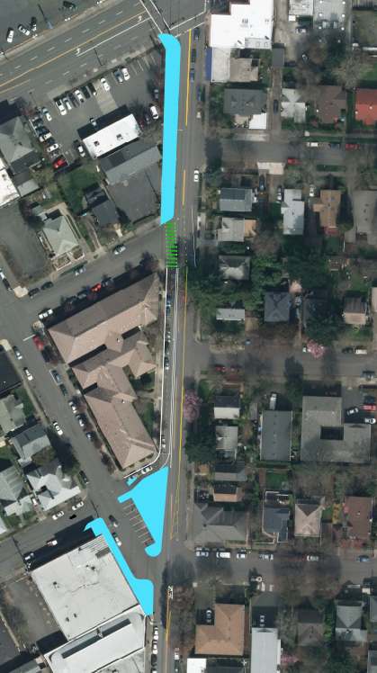
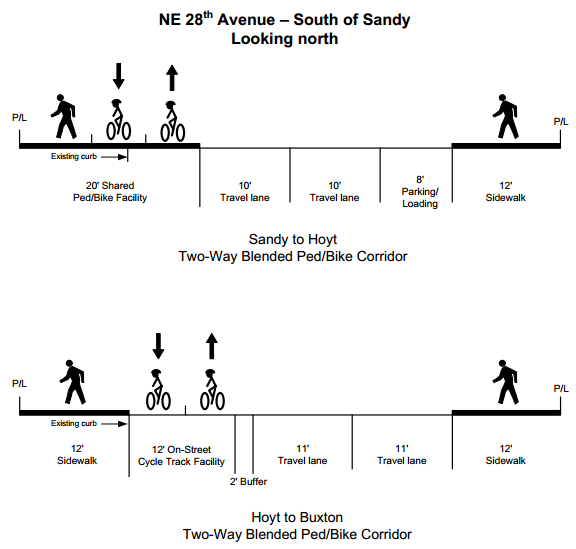
For the section just south of Sandy, PBOT project manager Rich Newlands suggested a facility that would move bike riders up onto a “Two-way blended ped/bike corridor” for one block (a newly paved area marked in teal below) and then across a painted bike crossing to run at road level for the southern block:
Here are cross sections of what each of these two blocks might look like:
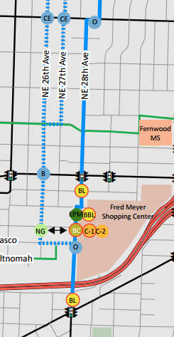
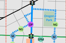
Kirk Paulsen, who lives near the north end of the proposed route and serves on its stakeholder advisory committee, said that north of Wasco, the city’s latest idea is to direct riders left onto a neighborhood greenway on 26th and/or 27th (the dotted lines are possible greenway routes; the solid line is the existing neighborhood greenway path specified in the 2030 bike plan):
South of Hoyt, Paulsen said, this would require removing one block-face worth of on-street auto parking, some of which would be offset by new parking spaces adjoining a new public plaza area. Paulsen said he fears the city will be unwilling to devote even that much new space to bike access, and will instead try to zig-zag the bikeway southwest on Hoyt to Randall, then southeast to Buxton, then back southwest again. Another option is to move the whole operation east of Oregon Park:
South of Buxton, the debate is whether to invest more of the project’s $2.5 million budget in traffic calming on 28th or on getting bikes to cut west of the commercial district to 26th Avenue and across the playground of Da Vinci Middle School:
“Their plan is to just throw down the green-backed sharrows” on 28th, Paulsen said, and let bolder riders mix with traffic on 28th while others stick to the “official” greenway-style route on 26th. “This is just with the understanding that they’re not going to touch parking. Assuming that’s the case, then the next best thing is to just put it on 26th.”
There’s not enough room on 28th to create bike lanes in both directions unless the city stops providing on-street auto and bike parking on both sides of the street.
Further south, near the Clinton Street Theater, Paulsen said there’s a similar problem: unless one auto parking lane is removed from SE 26th, there’s enough room on the street for a buffered bike lane in one direction but not in both directions.
“Obviously a world-class cycling facility would have a buffered bike lane on both sides, because you removed parking.”
— Kirk Paulsen, on plans for SE 26th Ave
“Obviously a world-class cycling facility would have a buffered bike lane on both sides, because you removed parking,” Paulsen said.
Paulsen, who also has concerns about the connections proposed near the north of the route and thinks 32nd Avenue would be more useful than 27th, said he’s already discouraged about his first public process, which he had hoped would be a chance to at least envision a facility that prioritizes walking and biking above driving.
“Already the compromises are being made before they’re having to compromise,” Paulsen said.
— Learn more about this project on PBOT’s website or browse our past articles in the archives. If you’d like to meet Kirk and other local transportation activists to discuss this project, join the Active Right of Way Happy Hour from 5:30-7:00 pm tonight at Tugboat Brewing (711 SW Ankeny).
Updates 12:50 pm: Corrected a couple typos. 2:55: Corrected to say this is the only “street-level” bikeway; the I-205 path is also continuous. Also removed a reference to auto parking on both sides of 26th south of Clinton; it’s only on one side during the stretch being discussed.


Thanks for reading.
BikePortland has served this community with independent community journalism since 2005. We rely on subscriptions from readers like you to survive. Your financial support is vital in keeping this valuable resource alive and well.
Please subscribe today to strengthen and expand our work.
Another option would be to make 28th one-way for auto traffic, presumably northbound. This would allow for a two-way cycle track, plus on-street parking, which would also serve to calm the one-way auto traffic.
A street section could look like this:
http://streetmix.net/GarlynnWoodsong/8/28th-street-one-way
Sure, autos would not have a corresponding one-way street southbound. But, arguably southbound auto traffic must choose to divert at Stark Street anyways, where 28th effectively ends service as a through street for cars; this would just push that decision point further north, to Sandy. Drivers would quickly figure out alternate routes to enable access to 28th.
What’s troubling is that this alternative was brought up to the City repeatedly, but they thus far have refused to give it serious consideration, even though it appears to be a win-win:
– Bikes get a two-way protected cycle track
– Parking gets to remain on one side of the street for cars
– Traffic remains calmed and the pedestrian environment is protected
– Bicyclists of all ages would feel comfortable using the facility
Why shouldn’t such a potentially promising proposal be given serious consideration?
This is an interesting idea. I think the emergency route classification would be a barrier, and businesses tend to like maintaining two way streets (ex: defunct W Burnside/Couch couplet). I will bring up the idea at the next meeting. Thanks!
This helps 28th at the expense of every parallel neighborhood street in the vicinity. I have a feeling that nearby residents would be up in arms over all that southbound auto traffic being diverted through their neighborhood. And rightfully so.
I think the majority of through traffic would divert to SE 20th or SE 39th. Diverters or stop sign turns on the neighborhood streets would help guide motor vehicle southbound traffic to those streets.
Highly unlikely. Nevermind the 1/2 mile out of direction, you can’t legally turn left from Sandy westbound to 20th southbound.
I know people that avoid 28th in a car if they are coming from Burnside or Glisan because there are too many bicylists. You are correct about Sandy. There are other streets that feed it, though.
“There’s not enough room on 28th to create bike lanes in both directions unless the city stops providing on-street auto and bike parking on both sides of the street.”
There’s a point where I just feel like I am spamming BP. Portland is one of the only towns that I have ridden in that allows THIS to happen! Everywhere else that I have ridden; small towns to BIG cities, they have NO PROBLEM whatsoever removing one side of parking when there is no room for both sides of motor vehicle traffic to pass each other. Which on 28th – there isn’t. With semitruck drivers turning on Burnside, Couch AND Davis, it makes it really hairy (harry?) – scary! In both a car and a bike to navigate. Especially when there is little room to adjust for sometimes less than unpredictable actions. (Everyone’s human and you can’t always see turning signals on a 20′ vehicle until it’s right THERE, right?)
I don’t see how rerouting cyclists to 26th is an option. It’s a lip service. And I’m offended, by the way. If I am coming from Fred Meyers and coming to the SE I am going to take 28th. I won’t be rerouted like lesser traffic. Plus, you’re cutting people through a school. Which is not cool. Especially since the curb cut there is sometimes blocked by a-hole parking. Also there is apartment construction right now and that’s about to be cluster-f once that’s finished.
Also drawing pictures on roads in green paint does nothing. Giving LANES does something.
I’ve lived off of 26th and Burnside since 2008 (just moved recently, but five years of intimate knowledge of that neighborhood – and I still work in that area so am commuting there every day) and am well aware of that intersection and the nuances of that area; living, working, walking, driving, cycling and public transport.
But we’re special in Portland because the blocks are really short……..
“Everywhere else that I have ridden; small towns to BIG cities, they have NO PROBLEM whatsoever removing one side of parking when there is no room for both sides of motor vehicle traffic to pass each other.”
Except you can’t just remove one lane of parking here. The street is so narrow (36 foot ROW) that you have to remove both.
That’s not true at all, that’s exactly what they are proposing to do on much of the 50’s bikeway.
52nd has 40′ ROW to work with south of Division. That extra 4 feet makes all the difference.
Sorry, I misunderstood “here” to mean Portland, and not this specific street.
Sorry 36 feet from curb to curb, not the whole ROW (including sidewalks). Moving curbs around would require a lot more $$$.
Ditto here. I also lived on SE Stark & 28th (ON 28th) for 5 years, and just recently moved. It is one of the busiest bicycling streets in all of Portland, largely because it is narrow, intimate and direct. Plus, most traffic turns off onto Stark, Burnside, Glisan, Sandy, etc – normally not much through-traffic, as it is very slow.
I worry that
1) bike lanes will encourage MORE through-traffic once the slow bikes get out of the way
2) Getting bikes out of the way – or off the street entirely – will make the street more dangerous than it is today.
Bike lanes plus speed bumps?
Only businesses in Portland get mad when parking is taken away? Dude, no. This happens in every city with every business where parking is taken, or meters are installed, or new parking regulations are instituted. This isn’t unique at all.
Yes, people do not want to lose the “free” parking. Anyone remember how the Hawthorne businesses responeded when Sam Adams talked about putting parking meters there several years ago?
I’m inclined to agree…The “stake holders” technically have no right to ask for anything (on street parking or inversely bike lanes) on the city streets. I’m pretty sure as a property owner the city has got the right of way through roughly 1/2 my front yard as it stands now (legally called an easement I believe). Personally they can take what they haven’t already, I’d gladly give up the mowing and maintenance to them.
Property ownership legally doesn’t give you the right to dictate to the city what happens to the street in front of your house. If it did I’d have twice the number of streets lights on my road as there is currently, speed bumps, and the utility lines would be below the ground.
Though I suppose that it gets more complicated when stretches of the commercial properties of this project are owned by very few entities (hint hint – that means they have enough money that they have influence that most of us couldn’t dream of having).
Thank you Michael for writing about some of the concerns related to this route!
I just wanted to highlight that the area near the Clinton Street Theater that the story mentioned I was worried about (due to the lack of political will to remove parking), is the area south of Taggart (http://goo.gl/maps/oaVoK) where there is only ONE lane (not two) for auto parking. If removed, you could have buffered bike lanes in each direction, but the current plan is looking into the idea of taking the existing 4 foot bike lanes, combining that width onto one side of the roadway, and creating a one-way buffered bike lane with NO bike lane in the other direction.
This idea would then combine an alternate route nearby for the ‘neighborhood greenway’ type of experience that many of us are used to – but the issue that I am concerned/wondering about, as well as others that are providing this as an idea, is what this will do to bike traffic wanting to travel along the commercial stretch of road – will they take the lane? will there be a large increase in ‘salmoning’? is that a better solution than two sub-standard 4 foot bike lanes in both directions? will most riders on that road today prefer to be on the ‘neighborhood greenway’ a couple blocks away? You input is appreciated to help direct the process.
narrow two way bike lanes are slow and conflict-ridden. i would not feel safe riding in this kind of infrastructure and would likely just take the vehicle lane.
I would say upgrade the 28th place traffic light at Division and make that the main route from the 27th street traffic light at Hawthorne south to Taggart and the High school/ Max connection.
My last comments about our goals to reach 25%:
– We need to make biking routes as DIRECT as possible.
– We need to make biking routes as CONTINUOUS as possible.
– We need to view thoroughfares as streets for moving people to destinations, not storing objects.
If we fail to address each of those ideas, we fail to create a world-class bicycle facility, and will easily fail to reach 25% by 2030. Will it be an improvement from what we have now? By all means YES! Can we do better? I’d love to see us try.
You forgot another point: must be COMFORTABLE for people to want to ride.
Totally agree. I’m sure others can add to this list of items, as well 😉
Quoting from the article:
“The big question for this area is how (or whether) to make the bikeway comfortable enough so that people “8 to 80″ years old will want to bike through the popular commercial district, just as the city’s Bike Plan for 2030 recommends.”
Bwaaaaa – ha – ha – ha – ha! ROFL!
A big question indeed!
I’ll add to some of the other comments here by reiterating what we all know is the elephant in the room — that lovely third rail of transportation planning — AUTO PARKING.
I have not read the city’s “Bike Plan for 2030”, in part because I’ve read enough elsewhere to (correctly?) assume that the “recommendations” in the plan are nonbinding.
When push comes to shove, the will to remove parking is not politically expedient for those who likely won’t be around to answer for the failure of “the plan” in 16 very short years.
Do we *seriously* think that eight or eighty-year-olds will “take the lane” comfortably ANYWHERE in this city without a dedicated non-car lane??
The only time I’ve ever seen 8-80 year olds riding bikes together in this city at the same time *spontaneosly* is on the Marine Drive bike path and the Eastbank Esplanade (where cars, and shops, are nowhere to be seen).
25% of all trips without a car by 2030?? Really??
Consider Sunday Parkways: which is the only time I’ve ever seen 8-80 year-olds riding bikes together in the truly urban environment anywhere near where people might think of actually going with their cars (on a closed course, no less, with no parked cars to boot!).
I’ve seen estimates that upwards of 30,000 people have attended a Sunday Parkways before. So the people, and their bikes, are out there. But 30,000 people on a good day is only, what, 5 PERCENT of Portland’s population?
So…. under idealized riding conditions which will NEVER exist anywhere in the real world, how can planners mention the “25% by 2030” thing with anything close to a straight face??
Seems to me the only way to get from here to there is parking removal, starting WITH THIS PROJECT.
And the only to get that to happen is to get politician’s attention with the only red meat that works — $$ (and the votes that $$ buys).
Is there no way to combine bike infrastructure improvements over the next few years with private sector investment that can defray the perceived losses from disappearing parking?? And augment the paltry grants dribbled out from the Feds?
Why can’t this be a win-win for EVERYBODY??
How about:
1) Encouraging Google to provide free wifi along urban bike lane corridors for citizens and local businesses in return for Google ads or logos painted on the lanes?
2) Offering tax credits to select constituencies is a time-honored pork project tradition of polititions. What if the city offered tax credits to local businesses served by dedicated bike lanes. Tax credits could escalate for those businesses who can demonstrate increased sales to those who arrive by bike? Metrics could be gathered via smart cards, phone apps, RFID tags, or other technologies offered for free to cyclists by the businesses involved and underwritten by health-related businesses such as Nike, Moda Health, or Strava, with concomitant logo exposure?
Longer-term:
Sunday Parkways-style events could be held *every day* of the week throughout the summer months in a rotating selection of urban business zones as a business-development project and transportation feasibility experiment.
Each district would only have to “suffer” through the scourge of limited street parking and temporarily-live bike lanes and cycling traffic for a week until life returns to “normal”. The largest “anchor businesses” in the area could be encouraged to underwrite the week in return for tax breaks commensurate with the success of their “week”. Maximum media exposure could be used to promote businesses along the route, locally and nationally.
Politicians could closely monitor data from the experiment to uncover success stories and fertile areas of positive response from the electorate in order to identify “communities of the willing” deserving of initial infrastructure dollars towards the 2030 goal.
Mike, I will stop at nothing to veto your terrible idea to get Google to provide free wifi in exchange for billboards. All ads must die. No way I am going to sell out the commons to an ad company. The streets are for people and art and culture. Not words from sponsors.
(Using adblock plus.)
Seth, I’m not a huge fan of the idea either, but non-cycling motorists (and the politicians they vote for) are not going to spontaneously give up parking without getting something in return. What are you prepared to give them??
meh. my 2nd grade neighbor bikes to school.
It’s starting to feel like the Eternal Recurrence. An opportunity arises to do the thing right. City immediately begins caving on key aspects of doing it right. We wind up with a half-baked “solution” that’s obsolete before it’s implemented, and we’re stuck with it for the next fifteen years. As a bike rider who’s already pushing 60, I’d like to live to see REAL F’ING BIKE INFRASTRUCTURE in this town. But the signs on this one are pointing to “Sorry, old lady. Not gonna happen.”
What Kirk said. As a side note regarding the storing of objects, parking an automobile should never, ever be free unless it’s a privately-owned driveway.
My neighbors car has blackberries growing from the planter strip, up through the cab, and out the windows, it has been there so long. Also doesn’t have tires anymore – I think its been parked on the street for over 20 years!
Seriously. My wayfinding since moving here consists of “there’s that old Chevy truck that’s ALWAYS there” then “on to where those old French Citroens sit…” etc.etc. It’s very dependable. Houses, condos, storefronts all seem to pop up and disappear too rapidly.
Just want to point out that the rapid construction of many new apartment/condo projects around 28th and Burnside (all over the inner East side, for that matter) make getting the bike infrastructure RIGHT the first time even more important. You can’t build your project hoping all your tenants will bike and walk, then not advocate for excellent facilities nearby.
I think these “low car” infill apartments buildings should be required to have their development charges be dedicated to improving local access to the active transportation network instead of it disappearing into the general fund. If you want to build a big apartment building, there must be an ADA complaint sidewalk to the local bus stop and access to the local bikeway network.
Michael, are you not counting the 205 path as a bikeway because it’s a MUP? Somewhat semantical.
Good point. I’ve added “street-level” to the phrase above.
Why not let both the business renters* and people traveling by all modes try removing on-street parking in the “contested” business districts? It could be done practically for free. You could easily try this before you buy it. PBOT could put out temporary “No Parking” signs like those used for paving or street maintenance. Keep them there for a year and see the effects.
Are we so afraid that we can’t even try? Will parkmageddon on the 20s bikeway kill us all? Will every business be obliterated? Seriously. Let’s take the long view.
This is an opportunity to correct a past mistake of allocating 100% of the roadway to motor vehicle use – especially in the “business districts” along the route. While this has not prevented people from risking their necks to take the most sensible and direct route, it’s not a fair allocation of the public roadway resource.
There are puddles, ponds and literally oceans of parking along the route. From Broadway to Stark, for example, don’t want to give up a parking spot at 28th and Broadway? Can’t see the *ocean* of parking across the street at Fred Meyer? Zoom out a bit on the map view and anyone can see there are a lot of parking resources around all along the route!
How about some more community spirit from the business community? If the need for parking is so key to economic vitality, let’s see the business community invest in it like they mean it and not just take a free park at the public’s expense? How about a local parking garage? How about some parking share between parking lot owners?
There are so many cases where removing parking has lead to much better than expected outcomes for all parties. Ooops, a big success. Shhh don’t tell. I mean the list goes on and on foreign and domestic. Times are changing. Ignore those successes at the peril of those young and old injured or killed just trying to travel safely to their destination by foot or bike.
Finally, I would just like to say that sidelining people to some back street or alternative route is fine in some contexts, but is misguided for the 20s bikeway commercial areas. Trying to direct people traveling by bike away from businesses misses the point that many people travel today by bike explicitly to visit those businesses. To spend their money at them, or work there. Don’t prevent safe access for people traveling by bike from being developed directly to the places people want to go. Make it safer *and* direct.
* I’m using the term “business renters” here because most business owners don’t own the property on which they do business. They are renters just like residential renters. I did not want to use the term commercial renters as I thought that would be confused with the property management companies that rent out property for commercial and/or residential use.
This is absolutely hitting the nail on the head – 28th is so successful because so many people RIGHT NOW bicycle there, DESPITE the not-so-great environment. I wonder, considering that it is such a destination, if 10 mph speed limits and a woonerf-like environment would actually work. Put car diverters every 4-5 blocks.
Unfortunately, I don’t think that USDOT or whoever is the national org that writes the traffic codes allows speed limits under 20 mph.
Because of the oppressive, dangerous way that people in Portland aggressively drive their cars – passing too close to cyclists, tailgating, etc on this street, and the pressure they put on you to cycle as fast as possible, make it imperative that 28th have full-lane width cycle lanes on BOTH sides of the street!
Relegating people on bicycles to detour 1/4 to 1/2 a mile out of your way will guarantee that nobody will ride on it, and thus cycling infrastructure in general will be viewed as a failure, and it will be 20+ years before the city builds any new improvements. Don’t think for a second that Oregonlive and the local news anti-bike mafia will jump all over the future “boondoggle” of wasted public funding on failed cycling infrastructure.
“business renters”
renting from a bank (mortgage) or even owning property outright should not confer superiority in a democracy.
I often find in public discussions, like the meetings for the 20’s bikeway, that priority is given to people who own a business or own their home in discussion of use of the public right of way. Lowest priority is given to the lowly residential renter who is determined not to have any stake in the neighborhood, city or our future. That doesn’t really make any sense.
Yet business owners are very often business renters. Not too different from the residential renter after all. Their place at the side of the road is so often temporary.
If bike licenses aren’t worth the revenue, is it more practical to meter every space in the city? Collection and enforcement costs would be astronomical.
If direct and continuous routes are useful to people on bikes, are they not useful to people in cars? However you get around town, it shouldn’t be ridiculous.
If the street can’t fit two directions of car & bike lanes each, can they not share? All bike trips involve mode mixing; narrow roads should be slowed appropriately.
Since we know that increasing bike traffic and accessibility improves economic outcomes for small businesses, let’s take our bike corridor and shift it AWAY from a popular stretch of small businesses, in order to protect the car parking which we already demonstrated was less economically beneficial!
It’s mind-boggling to me that Portland / PBOT can’t get with its OWN program!
I’m growing increasingly concerned that Portland’s “let’s compromise with everyone” style of governance is not going to fare well with the city’s increasingly rapid population and economic growth… such an environment makes infrastructural mistakes significantly more costly.
“Their plan is to just throw down the green-backed sharrows”
While I would prefer parking removal, the fact that the city is willing to consider green-back sharrows on an arterial is real progress. We desperately need these on Hawthorne, Division, 21st/20th, Alberta, Mississippi, Milwaukie/17th etc.
And on-street parking once again rears its ugly head.
Just one caution on this writeup (which otherwise is a good presentation of the issues in this area of the 20s Bikeway Project) — PBOT has certainly indicated the possibility of sharrows or enhanced sharrows only on 28th, but it isn’t “their plan” in the way that Kirk’s phrasing suggests, “Their plan is…” It’s one of the options that’s been presented to the SAC (which I’m also on), and it’s one that everyone on the SAC and everyone at PBOT acknowledges would be politically ‘easy’. But that doesn’t mean it’s anyone’s plan right now.
If you want to share your opinions on this project, please do one of three things now:
1) Attend tonight’s AROW happy hour on the project at Tugboat Brewing, 5:30-7:30pm. Three members of AROW are on the SAC, and we’ll be there discussing the project and getting input for our next meeting.
2) Send your thoughts and ideas, ***politely***, to Rich Newlands at PBOT, who is the project manager. (Be nice! He already had to listen to all the complaining about the 50s Bikeway.)
3) Plan to attend one or more of the area open houses that are likely to be held in January 2014 to give input on the alternatives that have been selected as preferred/recommended and whether they meet the project objectives (and whether the project objectives are correct).
Without really strong community support for an excellent bikeway solution, what gets put forward might not be your ideal, so please take the time to voice your ideas and support for high-quality bikeways.
I want to have it on record that I agree with everything you mentioned in your above comment, Alexis, and I think a bit of that information was lost in translation – as I was referring to ‘their plan’ being the ‘compromise plan’ when talking with Michael, where the result would be ‘just the sharrows’. Personally, I’d love riding on the existing roadway much more if there were *at least* sharrows there, and through these discussions hopefully we can come away with even more improvements than only those. I don’t want it to sound like there is a single plan in the works and green-backed sharrows are the *only* thing being considered.
Perhaps I’m missing something. The existing conditions document (http://www.portlandoregon.gov/transportation/63772) shows 36′ of road between Sandy and Stark. So my maths want to say two 9′ car lanes (is this possible?), one 8′ parking lane, and two 5′ bike lanes equals…36′.
Certainly not my ideal for biking, but at least I finally get some of my own space on the road. This street needs to be narrow to keep cars slow anyway. Peds need to and often do cross at almost every intersection.
Better to have 2 10′ car lanes (dont forget, there are very wide trucks that drive up the street), and 2 8-foot bike lanes/cycle tracks.
Done and done!
The standard for a truck route/Major response route is 10 ft auto lanes. The preferred is 11 ft – don’t forget the mirrors.
So exactly how is two blocks of two way bike path on the west side of the street going to help through northbound cyclists on 28th, who will have to cross over 28th twice to use it????
It already looks to me like this project is going to die a hundreds deaths from the mixing of multiple poor designs, and it’s just getting started.
I’d almost prefer they just left it the way it is, as I fear what it will become…
Quit talking of cutting through Da Vinci…. PPS ins’t going to allow it, And anyone with kids isn’t going to go for it either.
Public access to school grounds needs to be limited during school hours for security issues. As it is now there are enough problems with the public at most schools without public paths through them, with 2 kids in the PPSS, I can think of at least 3 different indecent exposure incidents at two different schools just last year, each time the”flasher” is an adult at the edge of the school grounds while the kids are at recess/just after school. You’re just inviting this kind of thing (or worse) to the inner grounds of the school grounds.
Save yourself a lot trouble and effort and quit thinking it’s even an option. I’m all for more infrastructure, especially on the east side (greedy self centered cyclist that I am). But I know I’m not the only one that sees cutting through Da Vinci as nothing but a really, really, really bad idea. I’ll admit my schedule doesn’t allow much time to attend meetings and the such, but I will make time to attend any public meeting to prevent a path through any school – and mind you neither of my kids attends Da Vinci (though my youngest wants to in the next couple of years).
My understanding (I believe this came from Alexis Grant, also on the committee) is that talks with PPS on this remain promising for the option. Doesn’t make it a good idea, but it might well happen.
http://www.oregonlive.com/portland/index.ssf/2013/10/north_portland_shooting_sends.html
http://www.oregonlive.com/portland/index.ssf/2013/05/southeast_portland_school_plac.html
http://www.kgw.com/news/Hillsboro-schools-changing-lockdown-policy–224653261.html
http://www.kgw.com/news/Reynolds-High-homecoming-dance-in-lockdown-227483281.html
http://kptv.membercenter.worldnow.com/story/23822207/deputies-irate-mom-threatens-principal-puts-school-in-lockdown
http://www.pamplinmedia.com/fgnt/36-news/196057-cornelius-home-invasion-prompts-school-lockdown
http://www.abajournal.com/news/article/2_men_with_assault_rifles_legally_take_a_walk_down_the_street/
These are just the BIG headlines of school lock downs within the last year of so. I only went back 5 page of a Google search and sorted out the same stories from multiple news sources. Probably not complete by any stretch, and it’s all from the actions of people that aren’t students, and each is in the Portland area.
This doesn’t even count some of the other incidents that don’t get reported or make head lines (police blotter stories) – which I’m willing to bet is much more common.
Now consider the last link as well. The 2 men weren’t doing anything illegal by walking around with guns on a public street. So by putting a path through the middle of a middle school. they could legally ride into the middle of the school ground with guns, and it’s not illegal should they start shooting.
is it the links that is keeping this one in moderation?
I would like to add that I mistype that last part of the last sentence should read “that it wouldn’t be illegal unless they started shooting.”
so how close is acceptible? One of the MAIN goals is to get children to school safely. Woodward and 16th run past highschools, Klickitat is next to a middle school I think. We at COPING are trying to connect every single school into an integrated greenway network. Why would a path next to a community garden be any different than riding past a school on the street?
until the first time a kid gets pegged by a cyclist at recess or something. Then it makes KGW. Then the fences come up during school hours. Then the Bike Portland article rerouting people all the way to 24th or back down crappy 28th. Plus all the parking issues in the next 2 months. The new apt on 26th and Burnside is gonna be 4 stories tall. Supposedly only 45 parking spaces underground or something. Parking on Monday in particular is already a nightmare because you can’t park along Couch or 26th due to the semi trucks loading. They block the curb cut. Or after school when the soccer moms block the semis and they scream at each other and the semis back up traffic on Burnside 26th because they can’t turn due to all the kid/pickup traffic right there at that curb cut we are going to SOOOO rely on. Why do I know this? Because I watched it. Out my apartment window. For five years. Di Vinci school curb cut was my view. It’s NOT a viable option. Try again.
Why hasn’t anyone mentioned 28th needs to be repaved between Glisan – Couch towards Burnside? It’s like riding waves. So slooshy!
PPS has opposed such access at every other potential property crossing.
I agree, and would myself be uncomfortable about bicycling THROUGH school grounds on my commute. A park yes, a school no.
It is difficult to tell the differnce sometime as many of our parks butt up to schools. How close is too close for comfort? Think about Madison High for instance, “the 70’s” could connect Tillamook with NE Sacramento/ 77th by building a path between the golf course and running track. Great for conductivity….but how close is too close?
Sheesh. Yeah, I’ll echo others’ sentiments here.
PUT IN JUST ONE FREEKING WORLD CLASS FACILITY, PORTLAND!
One. One. Just ONE!
Somewhere! Anywhere! Just put one in! GAWD!
Anyway, I can’t wait to read the next decades worth of stories about this project.
Sorry but have you biked in any other US city?
The bikeway has to have traffic signals where it crosses the major east-west streets. Period. It simply doesn’t work otherwise, not for users from “8 to 80”.
Time to transform NE/SE 28th between Sandy and Stark into a real world class multimodal public space safe for all users. Special pavement, special speed limit and a truly shared space. How about we make a PLACE! out of it.
Something that is almost always overlooked in any infrastructure improvement. People with disabilities rarely are considered when we look at making streets or bike lanes better.
If we looked at the Place itself as Lenny suggests, and made it somewhere to move around in, not move through, it would be a much safer and enjoyable place for everyone involved.
https://www.youtube.com/watch?v=xSGx3HSjKDo
This video is so lovely, I’m verklempt! What would it take to get just one, just ONE cross-city route like this?
The cycle tracks are a thing of beauty aren’t they? Portland will be lucky to have anything a fraction as cool as this by 2030.
Make 26th bike only but exceptions for local one way traffic within northbound bike lane. Keep all the parking. Prevent through traffic with blocking islands on cross streets. The only cost would be some islands, signs and painting.
Problem solved.
Or 28th. Either way, one for cars and the other for bikes.
I member the project manager for this saying PBOT would have to “get creative” for putting bikeways through the commercial districts. I guess “creative” in this sense means “get creative about how little we can actual do to improve cycling or how far out of the way we can force cyclists to travel and still call this project a success.”
Doesn’t PBOT have a ‘fire friendly’ speed bump it’s testing that could be used on 28th to slow down traffic and make it a shared street?
Why does every street have to be available to through automobile traffic?
They don’t, but 28th is one of few roads that cross I-84.