(Photos © J. Maus/BikePortland)
Advisory Committee meeting Tuesday.
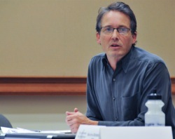
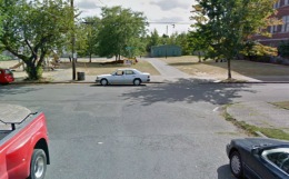
The Bureau of Transportation is off and running on their effort to plan the 20’s Bikeway Project. The project was given the green light a few years ago thanks to a $2.5 million federal grant. On Tuesday, PBOT project manager Rich Newlands presented the latest details with the Bicycle Advisory Committee.
While the grant funds both the planning and implementation of the project, before they break ground Newlands says they need to “better define what the line on the map in the 2030 Bicycle Master Plan really means.” In other words, the 20’s Bikeway is called out in the BMP, but now’s the time when the City needs to make concrete decisions about the route and what type of biking conditions each section will end up with.
“We need to be creative as possible.”
— Rich Newlands, PBOT project manager on creating high-quality bikeways through commercial districts
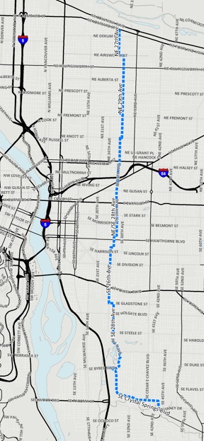
Once completed, this project will (hopefully) provide an absolutely crucial north-south connection that will run just over nine miles from NE Lombard Street all the way down to the Springwater Corridor path. Along the way it will go through 12 neighborhoods, connect to 23 existing east-west bikeways, 12 schools and 14 parks (within a 1/4 mile), and it will cross 17 major arterial roads.
As Newlands puts it, “It’s a huge piece of the bike network.”
–Download here–
At this point, PBOT and their stakeholder advisory committee (which has only had one meeting so far) have a general sense of the route and Newlands presented their latest thinking about it to the City’s Bicycle Advisory Committee on Tuesday night.
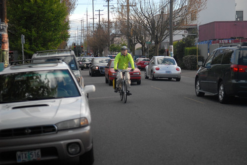
Starting in the north end, the route would begin at the traffic signal at NE 27th and Lombard. Then at Ainsworth it would jog east and continue south on NE 29th to NE Broadway. This section is defined by what PBOT classifies as “local service streets” with low auto speeds and volumes. “It’s similar to a neighborhood greenway environment,” says Newlands.
As the route crosses Broadway, the bicycling environment changes dramatically.
As currently envisioned, the 20’s Bikeway would utilize NE/SE 28th from Broadway to just north of Hawthorne. As anyone who has ridden in this area knows, the section between Broadway and Stark has relatively high traffic (average daily volumes are 6,000 to 8,000 cars per day). There’s also a dense commercial district between Glisan and Stark that currently has no dedicated bicycling space and a narrow 36-foot wide profile that is used by bike traffic, two lanes of auto parking and two standard travel lanes.
“One of the first issues right out of the box,” Newlands said, “is what do we do to get a bike facility on 28th?” That is a big question and it will be interesting to see how this planning process answers it.
– Download full version here –
Newlands said the City would, “Of course like to do bike lanes,” however, with a relatively narrow cross-section, he added that “there are significant trade-offs.” Even if PBOT decided to remove the auto parking lane on one side of the street (which Newlands said “would be a heavy lift”), that would leave only enough room for four-foot wide bike lanes — a width that PBOT considers substandard.
Because of the issues on 28th, PBOT is considering alternate routes on either side; but none of the options are ideal. If the route jogged over to 30th, not only would it require out-of-direction travel (a death knell for quality bikeways in our opinion), it would require a tricky crossing of Burnside. To the west, the route would have to use 26th Avenue, but that would be a significant detour.
Another consideration on 28th will be the discussion with business owners. PBOT and their stakeholder committee is already mulling how best to open up a conversation with them. Newlands hinted that, given the current rate of bicycle use on 28th (there are several on-street bike corrals already), many of the businesses, “Might be amenable to some sort of separated bike facility on 28th.”
Bike advisory committee vice-chair Ian Stude suggested a two-way bikeway on one side of the street. Another person brought up the idea of a bikeway couplet that would use 28th for one direction and an adjacent side street for the other.
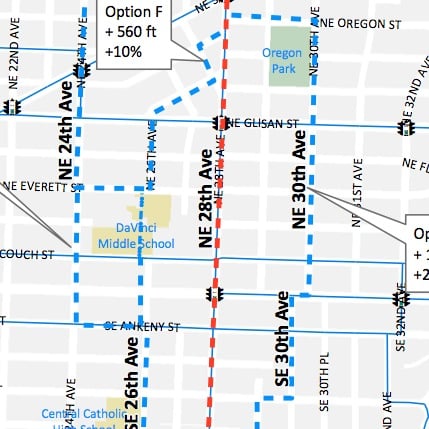
DaVinci Middle School grounds.
One very interesting solution PBOT is looking at would be to take the route directly across the playground of DaVinci Middle School. Newlands said they’ve already began a conversation with Portland Public Schools about that idea and the talks appear to be headed in a positive direction.
South of Stark, the route would return to a neighborhood street environment. PBOT shows the route staying on 28th all the way to SE Madison where it would then shift to 27th to use an existing traffic signal to cross Hawthorne. South of Hawthorne the route would jog over to 26th where it would connect to existing bike lanes that begin on Woodward and continue (across Powell) all the way to Gladstone. At Gladstone, Newlands says if the route stays on 26th, we’d have a situation similar to 28th where there’s a relatively high volume of auto traffic, two lanes of on-street auto parking and a narrow (36-foot wide) cross section.
PBOT’s current map shows the route jogging east on the Gladstone bike lanes to 28th where it would continue south and eventually connect to Crystal Springs Road and enter the Springwater Corridor at 45th Ave. Much of this southern section doesn’t have bike lanes and to create them (given the width of 28th) PBOT would need to swap the space currently taken by on-street auto parking.
Newlands said repeatedly on Tuesday night that “We need to be as creative as possible” in finding design solutions that result in a design of a high-quality bikeway that can pass muster with politicians, transportation advocates, business owners and neighborhood residents.
So far, it appears PBOT is committed to a direct route that will force important conversations about what our city values most when it comes to mobility. But the process is just starting and it remains to be seen how today’s preliminary lines on a map end up after everyone has had their say.
— To learn more about this project, see our post from back in July, stay tuned to the Front Page, and check out PBOT’s 20’s Bikeway Project website.


Thanks for reading.
BikePortland has served this community with independent community journalism since 2005. We rely on subscriptions from readers like you to survive. Your financial support is vital in keeping this valuable resource alive and well.
Please subscribe today to strengthen and expand our work.
Any update on the 50’s bikeway? There are hand-spray-painted marking s on 53rd between I-84 and Hancock, showing where sharrows will go. But they were there all summer, and there are no sharrows yet.
Never mind, I found this on the PBOT website:
“The project was put out to bid in June with the bid opening on July 9. Unfortunately, the bids received were all substantially above the project’s construction budget and original cost estimate. This indicates that the construction market is currently saturated with work. As a result, we will be re-bidding the project in November. The new anticipated construction start date is February, 2014. We appreciate your patience.”
Last I heard it has been suspended indefinitely, which makes me very skeptical of another bikeway being built. I had previously heard it was suspended until Feb. due to failure of the city to get any affordable bids on the job (which is the reason it was moved from this last July (the original date)). now who knows when it might be built?
Completely unrelated… However, any route planning that adds unnecessary hills is not ideal. If you want the average Portlander to bike, don’t add unnecessary elevation! This route will be a wonderful addition to the bike network.
even though SE 28th south of division has bike lanes, they are pretty lame. really narrow. hope this projects helps.
doubtful… city has poor record of updating existing bike infrastructure, even when ridership/use warrants it (a little green paint notwithstanding). nobody awarding any grant money for “maintenance” or “improve existing facilities” – it’s all about the new. and the opportunity to install more bengal tiger traps (aka storm water catch basins).
28TH South of Division is SUPER narrow, and is an unsafe cycling facility, specifically between Powell and Gladstone
I’m on the advisory committee, and yes, this issue is under discussion.
To make things clear, I think you’re referring to 26th, not 28th…
actually its both south powell since, if you follow the bike lanes, you zig up se gladestone from 26th to 28th. lanes are lame on both.
I would love to see this done, and have it connected to the Multnomah St. bikeway in the Lloyd District.
I really hope they find a way to keep the route on 28th. The other options involve a number of turns, every one of which is a negative. On other greenways, I have definitely found myself taking a wrong turn because I missed the (very subtle) signage telling me to turn a few block prior. Sometimes these are just going to be inevitable, but we should do everything possible to minimize the numbers of times that people are forced to make strange out-of-direction turns.
And really, if we can’t get bike lanes on NE 28th around Burnisde, what hope is there for ever getting bike lanes on Hawthorne or other major commercial corridors that badly need them?
They can build it on an alternate route to 28th if they want, but that would be stupid, because many cyclists will continue to use 28th anyway.
Meanwhile, can’t we at least get sharrows on NE 28th in the interim, while this thing is being planned????
It is against PBOT’s standards to install sharrows on streets with more than 3,000 vehicles per day. Since the volumes here are 6-8K, sharrows would be a hard sell.
PBOT should stop holding people who cycle hostage to this kind of rigid idealism. Advisory bike lanes, “bikes may use lane signs”, and sharrows may not be “world class” but they are better than *nothing*.
“It is against PBOT’s standards to install sharrows on streets with more than 3,000 vehicles per day. Since the volumes here are 6-8K, sharrows would be a hard sell.”
Really? Is this something that the MUTCD standard for sharrows recommends, or is this something else PBOT just pulled out of thin air?
I’m not sure where the guideline originates. I’m just telling you what Rich Newlands shared with us at the first SAC meeting.
Sharrows as defined by the MUTCD are meant for high-traffic roadways to remind drivers that bicyclists can use the full lane. We have muddied that definition by installing them on low-traffic neighborhood routes across the city (since we wanted the federal funding that came with installing an approved symbol).
Which is to say that the sharrow in Portland is now synonymous, for better or worse, with “low-stress bikeway”. 28th is anything but low-stress. Don’t use them.
ok everyone – get your Streetmix.net engines rolling. Set your street to 36′ between the curbs and see what you can fit in there.
Here’s the existing conditions to start from:
http://streetmix.net/nickfalbo/11/ne-28th-ave
Here’s one concept with a shared two-way auto lane and 6 ft advisory bike lanes (although the volumes on 28th are probably too high to pull this off):
http://streetmix.net/nickfalbo/10/ne-28th-ave-advisory-bike-lanes
More trees, for traffic calming.
http://streetmix.net/techieshark/11/ne-28th-ave-remix
Very cool tool, Nick. Thanks for sharing. I love Peter W’s vision for trees down the center. But, alas, I fear the area businesses wouldn’t go for it. Here is an unimaginative design that deletes all on-street parking, and adds in bike lanes and a skinny center turn lane/truck loading zone. This wouldn’t need to be continuous along the street and could also include center tree islands in places.
Advisory bike lane on 28th!
http://bikeportland.org/wp-content/uploads/2009/10/advisorybikelane2.jpg
I know there are people on the stakeholder committee already saying this, but…DON’T use 29th in the NE! The pavement is truly terrible quality (and I don’t think paving is included in any part of this project), and the section on Alameda Ridge is a very high grade. It would be better if they use 32nd, which feeds directly onto Regents, which has an easier grade. Then jog it back to 27th on Ridgewood. 32nd might seem out of the way (and not in the 20s–oh noes!), but I don’t know why they’re so focused on starting at 27th and Lombard. How many riders will actually come from there?
Topography and its impacts on cyclists is something else PBOT engineers don’t seem to understand.
Actually, topography is one of the objectives – http://www.portlandoregon.gov/transportation/article/465986
It seems to me that patching the pavement on the two blocks where it is bad on 29th, which appears to have been caused by substandard utility repair-and-patch jobs in the past, would be a small price to pay for the directness of route that you achieve by connecting directly to the top of Regents — at 29th. This would just require some coordination with PBOT’s street maintenance/resurfacing schedule.
“Four-foot wide bike lanes — a width that PBOT considers substandard.” I don’t care what is considered substandard. Four feet is plenty for me (and I know few bikers who require more), and well above the zero now. If 28th does not get a bike lane from Glisan to stark, this bike way will be worthless.
Four feet is worthless if you are riding in the door zone on one side of the street.
Point well taken. Simply put, I don’t want PBOT using this in their reasoning to not build a bike lane. I do dream of a cycle track on each of my few favorite streets (this being one).
How might a cycle track be shoehorned in? I would argue that, if possible, there would be a lot of benefit to continuing to have on-street parking on one side of the street — if nothing else, it provides a space for the bicycle parking corrals! 🙂
One option: Put the cycle track between the parking trip and the curb:
http://streetmix.net/GarlynnWoodsong/5/ne-28th-ave-remix
Positives: Bikes can pull directly in and out of bike parking corrals from the cycle track.
Negatives: One direction of bikes is in the door zone of those parked cars; car traffic on the other side of the street is directly adjacent to that sidewalk, negatively impacting the sidewalk dining experience for that side of the block (which would need to be the west side to work at all, since most of the restaurants are on the east side of 28th).
The other option: Put the cycle track on the opposite side of the street from the parking strip:
http://streetmix.net/GarlynnWoodsong/6/ne-28th-ave-remix-cycle-track-on-opposite-side
Positives: Cycle track protects pedestrians from cars on one side of the street, parking strip protects pedestrians from cars on the other. No bicycles have to ride in the door zone.
Negatives: Bicyclists must cross car traffic to enter or exit bike parking corrals located in the parking strip on the other side of the street.
I think I prefer the latter, what do you guys think? Is eight feet wide enough for a two-directional cycle track?
One of the primary goals of the project is to increase bike mode share. The city has a very ambitious goal of increasing mode share to 25%. One outcome of this is that the “design vehicle” (aka target audience) are people who are “interested but concerned” – http://www.portlandoregon.gov/transportation/article/158497
So the goal is to get more people on bikes, people who don’t already use a bike as a main means of transportation, people who may have different concerns and viewpoints relative to those of us who do ride a bike all the time.
Geller’s “interested but concerned” is a category he pulled out of thin air. IMO, the habit and convenience of motoring is the main reason most PDXers do not commute by bike. Until PBOT begins to focus on discouraging motoring AND creating more efficient cycling routes I predict another 5 years of mode share plateau.
spare_wheel, I agree that the City needs to focus more on disincentives to motor. However, I am pretty sure that low-stress bikeways (even meandering ones with too many stop signs like our current greenways) do encourage a certain set of Portlanders to bike. In my experience, these are people whose destinations are not too far away from their residences, and who have enough flexibility in their lives to devote a little extra time to biking rather than motoring.
A number of my coworkers have started biking in the past year, often for health and happiness reasons. Many of them take routes that are even more meandering than the greenway routes, just to go through areas they like visiting and see pretty things.
Now, these people are not a mass market, but they matter. You are right that in order to get a huge percentage of people biking, biking needs to be the most convenient and least-hassle choice for their trips. But, in my opinion, that will take more investment than just greenways.
“biking needs to be the most convenient and least-hassle choice for their trips”
i agree. and, imo, the single biggest failing in pdx is the absence of direct and efficient bike facilities on major arterials and collecters.
I was hoping that the SW Multnomah/Capitol highway project would be the first example of a cycle track on a major arterial:
http://www.portlandoregon.gov/transportation/article/343225
sadly the last news I heard about this project was that the project had been delayed.
Which of the greeways have ‘too many stop signs”?
The ones that aren’t built yet.
Bike advisory lanes will require putting up diverters at each major intersection (Sandy, Glisan, Burnside, Stark) to get traffic volumes down to a reasonable number. That’s a tough lift.
And I didn’t realize 28th was so narrow (I thought it was 40 feet). Getting bike lanes of a safe width looks like it would require removing BOTH parking lanes (in addition to numerous on-street corrals). An even tougher lift.
I am not envious of the planners on this project. It seems like no matter what they propose some stakeholder group will be outraged. But something needs to be done. The lack of any north-south transit corridors between 12th and 39th/Cesar Chavez makes the need for a safe, direct bicycle facility on 28th even more acute.
That’s just it Reza! If you assume some group will be mad no matter what, then why not just make the decision that most closely matches our adopted goals and plans and the one that provides the most return-on-investment to the city over the long haul? I hope PBOT planners would realize this and just do the right thing instead of watering down their intentions to appease the “outraged”.
Jonathan, do you think removing parking on both sides of the street really is the best solution? What about bike corrals? Where would they go?
Yeah but noone seriously drives to NE 28th, right? As a designer, it should be illegal to provide parking at bars!
I was at Alma Chocolates last week and overheard a woman who rolled up in a Mercedes complain there wasn’t enough parking on 28th. Seriously.
Why on earth is 20th-21st not being considered. It’s more direct and has a far higher volume of cycling.
Different corridor in the 2030 Bike Plan. Another awful route for cycling that should require removing parking.
And people want to bike where the destinations are. 28th between Glisan and Stark is a larger commercial destination than anywhere along 20th.
The ‘lot to lot’ width of 28th Ave. is 60 feet around Burnside.
Maybe it’s time for some out the box thinking for how to deal with 60′ instead of the curb to curb width of 36 feet…
I like bike paths.
But allowing the public free access to school yards during hours of operation is a bad idea. Any thing bad that might happen as a result of this would set back the idea of bike infrastructure immensely.
At least now there is some semblance of safety in school yards because teachers and school employees can tell people to leave that may impose or imply a threat on the children. Put in a bike lane and they don’t have that authority any more.
I hope PPS is smarter than this panel on this topic. It is a catastrophe waiting to happen.
PPS has denied requests to cross school property at several locations.
I ride between Glisan and Stark on SE 28th… A LOT! I would prefer to see the bike route stay on 28th, and if they were to use either alternates, I’d still ride 28th regardless what the official route is. Thanks for updating on this!
Personally, I could be coaxed off 28th. But only if every stop sign is turned on the alternative street and biking on the greenway given some sort of priority over cars at the major streets. Given the “good luck crossing this busy street, sucker!” nature of our current greenways, I sort of doubt that level of convenience is on offer….
Again, which greenways? Remember, all or nothing usually results in the latter.
Here we go:
the 20’s
http://a.tiles.mapbox.com/v3/coping-with-bikes.map-zsnzij82/page.html#13/45.5193/-122.6381
Here is our range of maps for context (Our half-mile greenway grid, the 2030 master plan, and a full build out with EPIM (East Portland in Motion):
Let me know if anyone can not see the maps. Some have reported problems, and if so what system you are using so I can report the bugs (terry@copingwithbikes.net). They look fine on android and windows 7.
At https://www.facebook.com/COPINGWithBikes we did a group ride about five months back researching alignments. North of Tillamook, we found that 28th/regents/26th worked the best as it has the gentlest grade, road surface and best visibility. There is also an opportunity for a Micro-Park long term like Holman City Park at the MONSTER intersection of Regents/Ridgewood/26th which is also the termination point of the Future Failing greenway and its connection to Alameda.
I wonder why no one has mentioned the hair pin turn north of Wasco? That stretch of 28th is even narrower than south of Glisan. We really need to keep the alignment at 26th and spend the quarter million for a HAWK at Broadway/26th as 28th is way too narrow for anything other than substandard four foot bike lanes even with removing the few parking spaces The neighborhood wants a proper crosswalk/crossing there anyway. If we ever get funding for Sullivan’s Gulch trail, the trailhead would be at 26th and Multnomah.
South of Oregon is the major contention point with no good choices. 36″ is too narrow for anything unless parking is completely removed. If you do a two way protected bikeway with parking on the other side, then you get all sorts of fun at intersections. For an “advisory bike lane” to work the traffic volumes would need to be much lower.
All summer we have been using the 26th street alignment and it has been working great. Of course, the pinch point is Davinci School. This could be built just like 24th and Klickitat, next to the community garden. I know people have reluctance to place a higher volume bikeway next to a middle school, but has there been any problems on Klickitat? There can always be a “5 MPH Speed limit during school time” for those two blocks assuming a proper crossing can be built at Burnside.
The narrow bike lanes on 26th could be avoided if we upgrade the traffic light at 28th place and Division (a few blocks of the surface are awful) and then find the funding for a new light at 28th place and Powell. This would take the route south all the way to Reed College and is another place the neighborhood association has been begging for a proper crossing. It also would avoid the trauma that would be removing parking between Woodward and Division around Clinton Street and provide greenway access to Raymond which give conductivity east to Lents.
South of Long is the other bottle neck. If we were thinking creatively, there would be an outreach campaign to Reed College to see if they would be willing to put some matching funds into being a partner for a direct connection through campus to Reed College Road. If not, then the 26th street bike lanes need an upgrade. Keep in mind, in theory, PBOT did apply for a grant to upgrade bikeway facilities city wide and this stretch is on the agenda…but I think this is a state grant and we do not know when or if it will come.
http://www.copingwithbikes.net will be adding a page devoted to the 20’s bikeway with our analysis, community input and updates with cost projections so we can work through these issues.
There is also the possibility of just cheaply striping narrow standard lanes on 28th between Wasco and Stark for those confident riders (a $50,000 project I would guess for that 3/4 mile stretch) then do a FAMILY FRIENDLY Greenway on 26th. As some have said, if a parallel route is built many would still use 28th.
Choices for all? It is ALL about what parking is worth when it comes to 28th.
I missed a link. These are our base maps for context.
http://a.tiles.mapbox.com/v3/coping-with-bikes/maps.html
My comment about putting a path through a school wasn’t just about possible collisions with bicyclist. Just because the path is designed with cyclists in mind doesn’t mean that only cyclists will use it. Numerous schools have paths that cross the campus, but none are open to the general public during school hours, and for a good reason. They are almost impossible to police.
And there is a huge difference between a community garden and a middle school. I’ve got two kids in the system and almost every year there are incidents of indecent exposure, lock downs from events in the neighbor hood, and other problems from the public at large – and all this is while there are specific boundary’s to the school facilities.
Allowing public access right through the heart of a middle school campus is foolish and naive at least.
I understand this Resistance and issues since there is not much room here for actual separation next to the school, hence the 24th street greenway option would be appropriate. The issue is according to PBOT’s own research the “Interested but concerned” do not like standard 4 foot bike lanes in the door zone (I have been diving into their reports all morning http://www.portlandoregon.gov/transportation/62816) which is the best we will get ON 28th between Oregon and Stark. The “8 to 80 crowd” only like buffered or protected bikeways if on busy streets which would require complete parking removal. This places us in opposition to federal accessibility and equity requirements for seniors and the disabled who would then not have direct access to the retail corridor, not even talking about local resistance.
If this is the case, then a “less direct” but 20 MPH qualifying route needs to be augments with the “inferior” facilities on 28th. I am ALL for choices here.
Klickitat, 23rd to 24th, is a public right of way. The school there is crossing public property. Bringing the public onto school property is a significantly different issue.
Broadway to stark, keep it on 28th
Some thoughts:
1. Going straight through the DaVinci schoolyard is a bad idea.
That part of the yard is right next to the playground and kids will be running across the bikeway when going to and from recess, playing frisbee, etc. Recipe for ugly bike-child collisions. Hardly any cyclist will obey a 5 mph speed limit. Also, note the heavy traffic on Everett St at school drop off and pick up times.
Possibly the bikeway can instead go to the east of the community garden, then come along the edge of the school grounds. That would work a lot better.
2. If the bikeway is to be on 28th from Glisan to Belmont, then I think it will have to be done, and can be done, by slowing car traffic rather than by creating separate bike lanes.
I ride that stretch most days, and car traffic is slow enough that there isn’t a problem simply riding in the lane. At a few spots the road is wide enough that the cyclist can hug right and cars can easily pass; the rest of the time, the drivers are cooperative. Therefore I think that if traffic calming features were added, and car traffic slowed a bit further, cycling in the lane would be fine for even the “concerned” contingent. I’m thinking a 20 mph limit, signal timing, speed displays, pinch points, speed bumps, etc. As a driver, if you are in a hurry, you take 20th or 39th/Cesar Chavez anyway.
The alternative of establishing bike lanes seems impractical. I think the road is so narrow, that both parking lanes would have to be removed. The impact on the many businesses, that make this part of 28th vibrant, would be serious. There are also houses with no offstreet parking. If practical bike lanes can be squeezed in with only the west side parking removed, that might be an option to consider, because there are not many businesses on that side until you get south of Burnside and some of those have parking lots.
3. The route absolutely has to have signalized crossings of the major east-west streets like Burnside. 30th is a non starter for that reason. Consider using 32nd instead. It has signals at Burnside and Glisan and Sandy. North of Sandy, or maybe between Burnside and Sandy, the route can rejoin 28th. South of Burnside, the route can join Ankeney then turn south.
As part of the Burnside High Crash Corridor outreach meetings, residents DEMANDED a high end pedestrian crossing upgrade at 24th and Burnside. They repeatedly voiced their concern that this crossing is unsafe even with a pedestrian island and crosswalk since drivers do not stop.
It is a $200,000 investment for a HAWK like on 41st and Burnside, but if we do either minor traffic calming improvements on 28th to slow traffic (the “phased approach” PBOT is recommending in the published reports) or implement an inferior 4 foot bike lane with one lane of parking removal, then 24th could be the greenway residential connection to Ankeny using 26th to re-hook up with the main 28th street bikeway south of Stark. Different routes for different riders and everyone gains.
Oh, the signals should include “bike crossing ” features – esp the button placed where it can be reached without dismounting .
Portland is pretty much the only town that I have lived in that seems to protest or at least seem to be obvlious completely to the idea of eliminating parking on roads that are simply TOO narrow to have parking on both sides of the street. NE 28th is a perfect example as you are coming in from Sandy towards E Burnside with all those shops and the bottling factory, etc. Why? WHY?! Is there parking on both sides of the road? There isn’t room for it? Its insanity. There’s a hill I often huff up on the Alameda Ridge that also has parking on both sides and then drivers come careening down scarily – again with barely room for two cars breath – imagine if I were driving!? When I lived in large cities and even in other moderate sized towns; these sized roads would have parking on only one side of the road to allow ample road user access. Then it would open it up to multi-modal options such as bike lanes, etc. If we are looking towards that triangle I saw where single serving transpo is lowest on the totem, then don’t pander to parking spaces. Make it less accessible. If they have to park on a side-street and walk a block. Good. I took the bus and walked two blocks. I’m not complaining. I stood outside for half an hour waiting for my darned transfer. Sharing the road means for all users. Not just the ones with the most government subsidies.
Native Portlanders have had free parking their whole lives. They expect it, demand it, and feel that the spaces in front of their houses are “owed to them” because of their property taxes.
It is a really difficult position to wrap your head around since this is not the way in most major cities…..we are become a major city (in the top 25 now in population) so we need to adjust our thinking.
“It is a really difficult position to wrap your head around since this is not the way in most major cities..” Really? Maybe not in the mega-cities like NY, Chicago and LA. But Portland isn’t one of them.
My experience in cities of similar order of magnitude in size (Minneapolis, Seattle, Milwaukee, Phoenix, Atlanta, Sacramento, Denver) or smaller (e.g., Boise, Duluth, Spokane), you might have tight parking in some of the more urbanized, trendy districts, but the overall situation in the prewar residential “streetcar suburb” neighborhoods (away from the arterials and heavily built-up areas) is almost EXACTLY the same as in Portland: there’s plenty of on-street parking available, most people park on the street in front of their house whether or not they have a garage, and a substantial number of homes don’t even have garages. In fact, I’d go so far as to say that it seems pretty universal in American (non-Mega) cities.
The one difference between these other cities and Portland is that most of Portland lacks alleys, which allow people to store their cars off the street if they don’t have a driveway in front.
I don’t disagree that NE 28th is a good candidate for parking elimination, and it is after all an arterial. Just calling out that Portland is far from unique in offering free on-street parking in front of a lot of people’s houses, especially if you’re talking about quiet residential streets. Oh, you weren’t talking about a quiet residential street … so careful with the generalizations.
You may be correct, particularly when it comes to alleys. I have live/experienced closely Chicago, Madison and Milwaukee Wisconsin. All three of those Midwest cities permit parking/control parking at three miles from the city center pretty closely….at least when to comes to the “trendy neighborhoods.” A generation ago visiting my grandmother there was not permit parking of course, but finding a space in front of her house was always a challenge…father complaining incessantly…and she was about the same distance from city center as 28th is here, maybe a little closer in. Even there though, once a week the car would have to be removed for street cleaning which we NEVER do here. The street cleaners just drive around the parked cars. The west/south side of Chicago is another story.
We will see how our own neighborhood acts as we are going to try to get permit parking around the MAX stop/Hospital to help alleviate some of the tension surrounding “infill” and congestion issues this fall.
Unnecessary turns in a bikeway have been found to deter people from using it. People hate traveling out of direction, no matter whether they are biking or walking or driving or riding the bus…
Professor Jennifer Dill and her colleagues at PSU found that, when they strapped GPS units onto bikes. Their published results (unfortunately not available for free) are here: http://www.sciencedirect.com/science/article/pii/S0965856412001164