
(Photo: Chris Sanderson)
At long last the City of Portland is making the crossing of E Burnside at 16th safer for everyone.
This intersection — which is just three blocks north of Buckman Elementary School — has been known as a safety hazard for many years. Back in December of 2007, I attended a rally at this intersection organized by the Bicycle Transportation Alliance (BTA) to show PBOT that young children and their families put themselves at risk whenever they attempt to cross it. Also in 2007, the Portland Police Bureau (in partnership with PBOT) did a crosswalk enforcement action at this location. In just an hour-and-a-half, they wrote 35 citations for Failure to Stop for a Pedestrian.
Back then, we heard promises that funding had been secured. Then we heard funded had been delayed. Basically, it was the same old story we hear about many places around town in need of small — yet urgently necessary — safety fixes.
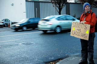
at this intersection in 2007.
(Photo © J. Maus/BikePortland)
Just last year, we followed up on this project after a reader — who lives in the neighborhood and has kids that go to Buckman — asked us about it. At that time, PBOT said the project might be funded through their Neighborhood Greenways program. Stephanie Noll, the BTA advocate who organized the rally in 2007, said she figured the delay was because the intersection needed a $250,000 traffic signal.
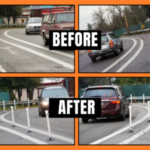
Fast forward to this morning when reader Chris Sanderson sent us photographs of construction crews at work. Turns out something is finally happening! It’s not the traffic signal Noll and many other people hoped for, but PBOT is installing a median island, a zebra-striped crosswalk, and some caution signs (similar to what they’ve recently added to neighborhood greenways).
According to Gabriel Graff, the operations and safety manager of PBOT’s Active Transportation Division, the money for the project came from a small fund in this year’s budget that was set aside for Safe Routes to School projects in the statewide Jobs & Transportation Act of 2001. The estimated cost of the project is $40,000.
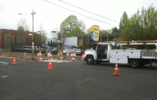
It’s great to see something finally happen (even if it’s not a full traffic signal); but it’s also frustrating to think a measly $40,000 project took six years to come to fruition. It also remains to be seen whether a median and some paint will do enough to tame traffic so that it’s safer and more pleasant to walk and bike across this wide, high-speed arterial. Stay tuned.
UPDATE, 2:20 pm: Graff says PBOT doesn’t have plans to install a full traffic signal at this location (in part because the median precludes that option). However, he did say having the median and crosswalk in place would make it easier/cheaper to install a rectangular rapid flash beacon sometime in the future. Here’s more from Graff:
“For context, new traffic signals run around $250,000, Rapid Flash Beacons with the presence of median like this ~$45,000. Either way, as you’re aware, the school and the neighborhood were very much interested in us doing something sooner rather than later and our budget for these types of improvements is increasingly tight.”


Thanks for reading.
BikePortland has served this community with independent community journalism since 2005. We rely on subscriptions from readers like you to survive. Your financial support is vital in keeping this valuable resource alive and well.
Please subscribe today to strengthen and expand our work.
That is why the #20 bus had to take a detour today. Good to see.
Thanks PBOT for putting this in!
I wonder how many other (Very much) needed improvments are already funded and waiting to go, but are just shelved (Sometimes for up to six years.)
Let’s build out the Bicycle Master Plan now, and watch the mode share numbers explode.
Naito Gap comes to mind. Still no progress and it’s been funded for years. http://bikeportland.org/2010/08/19/checking-in-on-five-stalled-bike-projects-38144
More info on Naito Gap, better link: http://bikeportland.org/tag/naito-gap
And they are right now installing one of these much needed “yellow strobe” crossings on SE 122nd – right at the Midland Library.
It is my understanding that businesses along this stretch of Burnside wrote a petition against this crosswalk. They actually wanted PBOT to do more like put in a HAWK signal or overhead light because they felt the crosswalk would do little to improve safety while also removing 20 parking spaces. This is a long overdue project. Let’s hope it makes things safer for everyone.
That is fine. Businesses can lobby all they want, but they are coddled in this city. If they wanted a HAWK, which would have been a great idea, to save the 20 parking spaces how about coming up with a plan to PAY for the added $160,000 for the HAWK upgrade. This would save the 20 spaces.
It would not have the double function of creating a pinch-point that slows down East Burnside Drivers, but those 20 spaces would be saved. Businesses however, in THIS city, seem to expect FREE on-street parking irrespective of safety.
$160,000/20=$8,000 per space. Which would mean if they accepted on-street metering, at $1 per hour assuming that the spaces would be occupied 5 hours a day, it would take five years to pay back the added cost. However, if the businesses really think they will lose business because of the space losses and you include that in the cost estimates that five year pay back time would be significantly less. Of course, if parking is in such demand than 5 hours a day is a low estimate.
People protest a lot in this city, they when a solution is put in front of them they say “I do not want to pay for it.”
Ugh. I need to let those business owners know their customers arrive on foot also. Excepting the busier commute hours, of course, because I didn’t feel safe crossing Burnside to buy my supplies.
I’m with you! At the Kerns neighborhood meeting, we were informed that Little Baja (the pot place) and Columbia Art and drafting tried to halt the (long overdue) project at the 11th hour due to the loss of parking. I’ll take loss of parking any day over loss of life. And unfortunately, both of those establishments have now lost a customer who likes pots and art supplies.
I wonder how much PBOT would have spent removing paint installed by a guerrilla activist (hopefully none). I seen proof that putting paint on the ground can provoke the correct response and raise awareness.
If the markings exposed the City to liability, whatever it took and quickly.
After using that intersection for awhile I eventually switched to going further east just to use the light at Burnside and 28th. Some days I felt like I was never going to get home.
How about trying to reduce the cost of these projects through streamlining. Then we can better afford them.
You’re going to have to defend your definition of ‘streamlining’. The work orders were finished 2 weeks ago after funding was confirmed.
The original delay was due to the Burnside couplet construction. If you recall, Burnside was all torn up so a pipe could be installed. The only thing the City gets more blame for than not doing something is doing something and tearing it out the next year for something else.
We were told at the Burnside High Crash Corridor outreach meeting that this intersection improvement was “in design process” and they implied that a yellow flashing beacon was to be included by the end of the year. Hopefully this is just the first step in that process.
Which is more important, a rectangular rapid flash beacon at Burnside & 16th, or MLK and Bryant, or SE 87th at Holgate, or MLK and Going (the latter 3 rrfbs delayed due to budget shortfalls)? The list only increases in the future with each new greenway completed. The national standard used to determine what to put there says the median serves up to 90 crossings per hour and adding the RRFB only gets you to 132 per hour, but cost $48,000 to $72,000 more to upgrade. If PBOT uses a standard of serving at least 50 per hour, Burnside/16th has met that standard. BTW, Going at MLK had about 100 peak hour bike crossings when last counted. The standard is NCHRP 562, for those interested. Also, the ‘all or nothing’ attitude is guaranteed to achieve the latter.
If you want an overall conductivity plan for the city west of I 205, you should check out our website and plan. Final numbers and cost estimates are in and we have an overall plan that would deal with every intersection you mention, plus a bunch more. It is modeled on “East Portland in Motion” and is over a years worth of research in the making.
https://www.facebook.com/COPINGWithBikes
We are going to be organizing a 1-2 group rides a month starting this summer, will be volunteering for intersection control at Holman City park during NE Sunday Parkways and have plans to start networking through the neighborhood associations. Everything has been broken down in cost including upgrades to about 25 intersections.
Great, now all we need is a spare $20 million.
Center medians cost $15,000-$20,000
Rapid Flash Beacons cost $12,000 per pole, two poles per crosswalk on a 2 lane street and 2 poles per crosswalk on a 5 lane crossing.
A better number for a green curb extension would be $30,000 and if there is also a bus stop, it’s $40,000.
And those are the numbers for city forces to do it. Add profit for a private contractor and 10%-20% contingency for unexpected costs.
I very much doubt that this facility will encourage speeding motorists on burnside to give right of way to cyclists. In fact, I find this route to be so inconvenient that I almost never use it. IMO, SE 20th is the *de facto* major SE-NE cycling route in this part of PDX. Its simply absurd that SE-NE 20th has virtually no infrastructure. Not even one splash of paint or one measly little sharrow.
20th is a collector street. Bike facilities there would need to have the process that occured on the 50’s and the budget.
meh. pbot could paint sharrows today.
and 20th is a collector street carpeted with speed bumps (at least in the wealthier neighborhoods).
Sharrows only function well on streets with lower traffic volumes, or in extreme circumstances where no other option will work (Like Bridge Access). 20th between 20-21st between Broadway/Wiedler and Division has significantly more traffic volumes than than are safe although their speed counts generally are within line of the 25 MPH limit. Counts range from over 6000 per day near Ladd’s Addition to over 10,000 a day near Stark.
In this case, the only safe way to put in bike infrastructure is to remove parking and add bike lanes. 20th would be the perfect north-south commuting corridor after the 17th ave Powell overpass and 17th ave bike lanes are added as park of of the MAX construction.
Of course that means parking would HAVE to be removed completely on this narrow street for it to work. Anyone want to start lobbing for this? With 20th is is ALL about parking…..even that stupid and DANGEROUS two block bike lane gap after the curve southbound from the Banfield overpass….everyone complains about parking removal.
“Sharrows only function well on streets with lower traffic volumes, or in extreme circumstances where no other option will work”
i find it interesting that you make such a strong ideological statement without citing any data. even more interesting is the way your generalization shows a tacit refusal to acknowledge that SE 20th is a street that *ALREADY* has high volumes of “people who bike”. i thought that according to the alta-planning/pbot rule book this simply was not supposed to happen. maybe the “people who cycle” do not know about the beautiful greenway a few blocks away. perhaps pbot should install some signs directing the “people who cycle” to the greenway. after all, sharing the road in pdx means getting out of the way of our fine motoring friends.
if my sarcasm did not make it obvious, i am absolutely fed up with being treated like a second class citizen by a city bureau that is theoretically supportive of cyclists. its not fun taking the lane on se 20th when some fool in a car is freaking out about being late for work. sharrows and “bike in lane” signs are a heck of a lot better than *NOTHING*! moreover, i strongly believe that in this area of pdx there would be strong support for removing parking. as a long time lilly white resident i can assure you there are absolutely no gentrification issues in inner SE pdx.
Hear hear!
There are no completed greenways parallel to the 20th/21st collector corridor. the 22nd corridor is still in the planning phases.
bike boulevard == greenway. and this is language that pbot staffers also use (e.g. less developed greenway).
Name one staffer.
20th is an extremely high volume street for cyclists. This is also the center for gentrification. My point, is that the city does not put in “cheap fixes” when everyone complains about every little dollar spent. PBOT generally does not do anything because of lack of funding unless it is a permanent fix.
The only permanent fix, for MOST cyclists, for 20th are bike lanes and parking removal. I take the lane if I am in a hurry. I have been city riding for 25 years. Most cyclists however do not feel comfortable doing that. The “Bikes on Roadway” sings on Hawthorne have done nothing over the past ten years and that street has four lanes so the cars can pass you easily.
PBOT would love to stripe bike lanes on 20th, it is the neighborhood associations that refuse to give up the parking. Go to meetings and lobby. If people would get over their entitlement about free on-street parking maybe PBOT would not have to be so frugal.
As far as the safety studies versus sharrows and bike-lanes combined with traffic volume and safety for MOST cyclist (not the fearless), that data is publicly available and supports my statements.
“My point, is that the city does not put in “cheap fixes” when everyone complains about every little dollar spent.”
I find it very ironic that you are throwing around terms like “cheap fix” in the midst of a thread about a “cheap fix” (e.g. paint versus a HAWK or traffic light). The perfect is the enemy of the good.
“”for MOST cyclists”
I would love to see you back this up with actual data. IMO, many, if not most, cyclists use 20th and 28th (especially when heading south).
“not the fearless”
stereotyping. i am enthusiastic, interested, relatively strong, and relatively confident, but I am absolutely not FEARLESS.
“that data is publicly available and supports my statements.”
i’ll bite. please cite a study conducted in the last decade showing a *significant* improvement in safety for arterial bike lanes (not a cycle track) versus sharrowed arterials.
“PBOT would love to stripe bike lanes on 20th”
i think this is true for some that work at pbot, but not for all.
http://bikeportland.org/2012/06/29/pbot-campaign-encourages-bikes-to-avoid-alberta-street-73999
just saying.
Ignorance is bliss. 20th north of Hawthorne is a collector street and to Burnside is a Major Emergency Response route. South of Hawthorne, the only segment with bumps on 20th, is a Local Service street and not a MER. South of Division, the road is 21st. 11 bumps in just under a mile is hardly ‘capeted’.
“Ignorance is bliss.”
in other words, if cyclists are riding where pbot does not think they should be riding — no infrastructure — nada.
“a Major Emergency Response route”
this is simply not true. i direct you to page 25 of the portland ” Emergency Operations Plan – March 2013″.
http://www.portlandoregon.gov/pbem/article/135813
“this is simply not true. i direct you to page 25 of the portland ” Emergency Operations Plan – March 2013.
http://www.portlandoregon.gov/pbem/article/135813 ”
Prove my point.
1. None of the ’emergency routes’ on that page correspond to anything 20 ish. Milwaukie and Chavez are the closest on the map.
2. The emergency operation plan is not the TSP Major Emergency Response route map.
Kyle Chisek.
http://bikeportland.org/2010/04/12/pbot-bike-boulevards-now-known-as-neighborhood-greenways-31887
I use this route quite a bit and I do think it will encourage those pesky speeding motorists to give right of way. In fact, I also ride down 20th nearly every day and find cutting over toward 16th on Irving to be very convenient. What they are doing at this intersection seems to be a lot like what has been done at MLK and NE Going, which I also find very convenient. I was very happy to see this construction happening when I rode by it today and believe it’s a decent start to making that crossing much safer.
this is not the first time that pbot has installed this type of band-aid.
i have been buzzed on multiple occasions while trying to cross se ankeny and chavez. imo, crossing at going and mlk in heavy traffic is also fool hardy.
one of the reasons i tend to avoid greenways is because i personally find them to be *more* dangerous than just taking the lane on a “collecter”. and judging from the very heavy bike traffic volume on 20th, i am not the only one.
Good luck riding Burnside through Laurelhurst. I’ll stick to Ankeney. I often have motorists yield their ROW to me at 39th and Ankeney, in both directions.
i often bike with my better half who does not have my…risk tolerance. ankeny did not pass the girlfriend test.
Ugh. 20th? Talk about a high-stress route (along with its sister 28th).So I can either put myself all the way to the right and risk getting squeezed by motorists in addition to all sorts of right hook and dooring dangers? Or I can fully assert my right to take the lane and promptly get buzzed and subject to other aggressive and menacing maneuvers? What a fun choice!
20th and 28th/30th needed a lane of parking removed yesterday to put bicycle lanes between Broadway and Division.
… or don’t put yourself all the way to the right, y’know? Put yourself 4-5 feet from the parked cars and you’ll be fine.
With the street seats program and bike corrals I doubt the local businesses and residents would agree with parking removal and bike lanes on 28th. It has been talked about for YEARS and is always tossed because of resistance.
There is however a parallel route that works well most times of the day. With an upgraded pinch point/beacon like they are installing on 16th on Burnside, then 26th could be great north-south route from Salmon to Oregon. Bike lanes of course are the only solution past the gulch, but 26th again could become the main repute if a HAWK or other solution is placed at Broadway. I take this route all the time and find it to be superior to 28th and MUCH less stressful even with the intersections as they are.
https://maps.google.com/maps/ms?msid=217379782128468346794.0004d265e9acae73f9719&msa=0&ll=45.52445,-122.63463&spn=0.038125,0.08935
22nd gets you from N Lombard south to Ankeny or Stark on low-volume roads with a short segment on 21st over the cut, and it’s part of the 2030 plan.
taking the lane is not that bad. in se pdx the vast majority of motorists respect our right to take the lane. nevertheless, i would still support the removal of parking and installation of a bike lane.
I’ve long wondered about this taking-the-lane business…. I personally very rarely do this because (a) I have the suspicion that it will be misunderstood by drivers as a flouncy gesture rather than precautionary, and (b) given (a) I actually feel safer with them passing too close than passing with anger.
Having said that, I wonder if an education campaign could help, or what such a campaing might look like. I know some folks ride around with the the phrase denoting the Oregon statute guaranteeing bikes the full lane sewn to their panniers or jackets. But this to me has seemed a bit obtuse since it usually involves only the number of the statute which one would presumably have to look up. I’m all for subliminal winks like this, but in this case I wonder if something less ambiguous could work. What do folks think? How might it be accomplished?
riding out of the door zone is basically taking the lane on this narrow but heavily used bike route.
20th should totally get sharrows! You can’t drive faster than 25 on most of it, due to the stop signs and narrow street width anyway. And cars try to pass you by playing chicken with oncoming cars (also a problem on SE Milwaukee in Westmoreland).
If businesses don’t want to lose parking spaces, then people should live with getting stuck behind cyclists.
There should be a crosswalk enforcement action somewhere in Portland EVERY day. Increase the fine to $500 and publicize the results and we’d have better motorist compliance. Or make the violator be a flagger in a school zone for a week.
I’m all for medians and crosswalks, but why do we have to spend $40k for infrastructure while ignoring the enforcement solution?
The State Legislature sets citation amounts and the Multnomah County Court determines the final fine. Portland cannot have it’s own courts, and the cost to switch is enormous. Portland has only a few traffic enforcement officers for the entire City, so until Council funds that section more fully, we do what we can do.
The median is there 24/7. The effect of enforcement disappears after a few hours or days, and enforcement is expensive.
“our budget for these types of improvements is increasingly tight”
“enforcement is expensive”
CRC! Ah, priorities…
CRC wasn’t funded by the city.
Did we hear anyone from city gov’t object to the CRC? Let’s not pretend these kinds of decisions, these out of money experiences we keep hearing about, don’t cross jurisdictional boundaries.
More like:
– Not raising gas taxes to account for increased fuel economy and inflation
– Rising cost of materials and labor
But no, let’s blame the bikes.
Am I the only one that prefers to cross here instead of at one of the signaled intersections? I don’t do it very often, but when I do, my 9 year old son is usually crossing with me on his own bike and we’re able to do it with very little hassle.
Granted, I do it before the first bell at Buckman school. The evening commute might be worse. Longest I’ve ever had to wait to get a big enough break for us to both cross has been a full minute or so.
I use this route everyday and welcome a crosswalk (and slowing of traffic on Burnside if it happens). Yesterday I had to brake hard when I pulled out past the sidewalk to look for traffic and realized I was in traffic. Luckily the car heading for me was far enough away that I could back up. I hope they paint a thick stop line to spark bikers and drivers to realize something is new to the intersection.
This makes me so happy. I use this route 4x a week and I’ll take even a small improvement at this point.
This is very welcome news. I have used 16th to cross Burnside for years, along with 28th, 20th, and 12th in this area. Also anything to make it more clear to other motorists when you slow down and stop at a location like this why you are doing so. Six years. Man, that’s incredibly frustrating, butI’m starting to not be too surprised by such a length of time. Unfortunately.
John, I made different experiences: last summer my son had camps at the Circle gym and I sweated bullets every time we had to cross Burnside: for me it was hard to estimate the speeds of the card, so we waited for gaps of at least half a block and those are long and far between… I think a traffic light will break up this “speed tunnel” nicely…
I just want to point out that only 2 parking spaces were removed for this project, not 20 as a previous comment claimed. The businesses on both sides of Burnside at this location did protest the project, because they feared the loss of those 2 on-street parking spots. Thankfully PBOT recognized that the huge benefit to pedestrians and cyclists outweighs the loss of 2 parking spots.
253 feet of curb space was posted as prohibited parking. Twelve spaces were removed.
Prove my point.
1. None of the ’emergency routes’ on that page correspond to anything 20 ish. Milwaukie and Chavez are the closest on the map.
2. The emergency operation plan is not the TSP Major Emergency Response route map.
Not much has changed in 3 years. Pedestrians and cyclists crossing Burnside still have to wait for a break in traffic flow. Vehicles just do not stop. I use this crossing every day. A light is needed here.