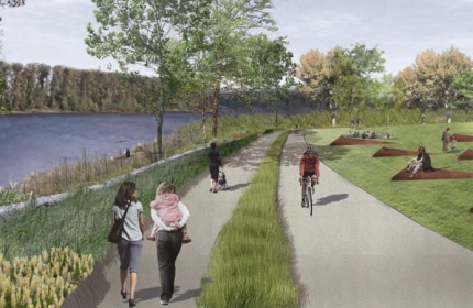
(Graphic: Portland Parks & Recreation)
First identified as a project in 2004, the new South Waterfront Greenway Trail is finally moving forward toward construction. The main snag thus far has been the acquisition federal environmental permits; but with a presentation about the project at City Council last week, it looks as the long overdue project is on schedule to begin preconstruction this summer.
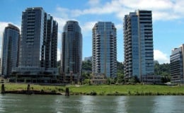
of the condos in South Waterfront just
south of the Ross Island Bridge.
Parks and Recreation Services Manager Eileen Argentina told BikePortland several things have come together to bring the project to this point:
“Over the last 8-9 months we have been working to see how we can balance the many goals and priorities the community has for this site – in particular ensuring that it delivers great value in terms of recreational, transportation, community and environmental benefits.”
Argentina says a major breakthrough for the project came when TriMet’s Portland-Milwaukie Light Rail bridge project already planned to work in the water adjacent to the trail site as mitigation. “We have been working with TriMet so that our project can help theirs, and their mitigation funds can then support the Greenway.”
TriMet is contributing $1 million toward the $8 million total project cost.
I tracked down a copy of the presentation made to City Council and found a detailed drawing of the upcoming trail. It shows a fully separated path for people walking and biking. Such separation doesn’t exist on any of Portland’s current multi-use paths but it’s sorely needed. While this is just a small segment of one project, hopefully it will serve as a demonstration that separation is needed on other non-motorized paths throughout the city.
Learn more about this project on PP&R’s website and from a recent article in the Daily Journal of Commerce.



Thanks for reading.
BikePortland has served this community with independent community journalism since 2005. We rely on subscriptions from readers like you to survive. Your financial support is vital in keeping this valuable resource alive and well.
Please subscribe today to strengthen and expand our work.
Yes Separate Paths!!!!
Call me cynical, but I have a feeling Portlanders will have a hard time using the proper path for their mode of transport. I’m specifically thinking lots of peds in the “bike” lane, especially since they’ll need to cross the bike path to reach the ped path… but hey! At least it’s a start, and it’s better than forcing everyone onto the same path by default.
I live downtown & I’m tired of bikers on the sidewalks. There are bike lanes. When there’s not a bike lane the bikes are to ride w/ the cars – not on the sidewalks! Bikers are to obey the same rules as vehicles but I don’t see that downtown. I see bikes on sidewalks, I see bikes running lights & stop signs. I’d like to see bikes registered w. tags so they can be ticketed. What a great revenue stream for PDX that would be!
There is already a law on the books that specifically prohibits riding on sidewalks within the downtown core. No bike registration needed – a cop is free to stop anyone doing that and give them a citation.
this is hardly a problem exclusive to portlanders 🙂
speaking of which, the only issue i have with that artists conception is – where are the geese? in my experience in that area, they will also need their own path. fortunately, theres not quite the nutria issue as on the east side, cause then wed be talking 4 paths…
No center line?
It looks like so many other neat little projects, its starts out nowhere and stops out of nowhere without good connections to other trails. Time to start treating our bike infrastructure as a network instead of a collection of novelties sprinkled here and there.
“Time to start treating our bike infrastructure as a network instead of a collection of novelties sprinkled here and there.”
Totally agreed, Hart!
After years and years of **talking** about around a dozen forever-stalled bike trails in the metro area, it’s time to finally, finally fund them. It will cost many $millions, but it will save literally $billions in road maintenance (since trails are the ONLY way to get almost any suburbanite to even think about cycling and therefore the ONLY way to get the bike mode split above 2% metro-area-wide), health care costs, transportation, stress, and so much more!
I will keep pounding the need for a dedicated trail network to every official possible. Ironically most of US that regularly read this amazing bike blog don’t need off-street trails; we feel safe riding almost anywhere. But painted lines on busy streets or even neighborhood greenways do very little for the vast majority of the metro area’s population. If we seriously want to increase the percentage of cyclists and to dramatically improve our collective quality of life, we NEED a fully integrated trail network!
Yay for separated wheel and foot paths!
Ted Buehler
“Call me cynical, but I have a feeling Portlanders will have a hard time using the proper path for their mode of transport.”
Seattleites have adapted well to the separated paths at Alki and Greenlake.
Separated paths FTW!!
Seems like a big waste of money to me. For one there’s already a path there. Second it’s only five blocks long, and it looks like both ends are only accessible by stairs?? The only people I see using this are the condo owners and OHSU employee’s on their lunch break.
OMG!!! Five blocks of car free travel. The average cyclist gets a 60-90 second respite from traffic. That’ll get the “Interested But Concerned” out in droves.
I fully support separated path for people walking and biking. I have used them in Vancouver, BC, and believe me – the established users straighten you out IN A HURRY when you are not in the proper place! Places like the Fanno Creek Trail are deadly with a single track path and many blind turns.
Fanno is a joke as a “multi-use” path. It doesen’t really go anywhere, and has lots of blind spots. If this is transportation infrastructure, we’re all doomed”.
Looks like it might finally be opening though, all of 4 months behind schedule.
I always assumed the Waterfront development would connect its riverfront bikeway with the one to the south that runs next to those office and condo complexes, so that you could get from the Sellwood Br. to…well at least as far north as that shipyard, with minimal street riding. Is that part of the long-term plan or is this beautiful new path for recreation only?
We have almost the exact same thing in West Seattle, and the pedestrians ALWAYS
meander in the specifically marked bike path.
After looking at the map I am disappointed. This little path is only a few blocks long and is only intended to serve those who live or work along it. I simply isn’t long enough to ride to draw anyone to it. I do not see the point of putting two paths i for such a short distance that is terminal at both ends.
I live down there and can say that I will never use this. Seems like a big waste of money to me. The current path is fine and so far out of the way that you don’t bikes on it other than a kid or 2. Even then there is a park 2 blocks away where they can play.
This is only the first section of the new South Waterfront Greenway. Only these 5 blocks are being built now because, I surmise, these are what the city could require the adjacent developer to build, or what the city has some funding for. The plan is for this same cross-section to cover the entire South Waterfront frontage. While the temporary transitions at each end might be improved, it’s probably better to build a partial trail while money is available, and then hope for the rest to be built when (or if) “the economy recovers” and more towers are built.