how to improve biking conditions on Highway 43.
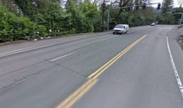
Clackamas County wants to make Highway 43 a nicer place to ride a bike. The County released a request for proposals (RFP) last week to find a consulting engineer to study the feasibility of creating a bikeway on the highway. Currently, Highway 43 offers the only direct connection between Lake Oswego and Portland. The road — with the Willamette River on one side and hills rising up on the other — is a two-lane, high-speed corridor with shoulders but with no specific markings or facilities for bike-only travel.
The RFP specifically states that the County is looking for someone to, “perform an alternatives analysis on installing bike lanes on Highway 43 between the Lake Oswego city limits and the Sellwood Bridge.”
“From Clackamas County’s perspective, we wanted to make sure we were not losing sight of lower cost alternatives… What can we do now?”
— Kathy Buehrig, Clackamas County Transportation Planner
Clackamas County is using $150,000 set aside for the Lake Oswego to Portland Streetcar project in order to pay for this consultant. The Lake Oswego to Portland Streetcar project is estimated to cost about $450 million dollars. Metro’s just released draft environmental impact statement on the project deals only with transit. A physically separate multi-use path (like the Springwater Corridor Trail on the east side of the river) is currently under consideration by Metro (more on that later).
Karen Buehrig, Clackamas County transportation planner, said they strongly support a non-motorized, multi-use trail, but they are looking for a more affordable option that improves cycling conditions in the near-term. “From Clackamas County’s perspective,” she told me via telephone this morning, “We wanted to make sure we were not losing sight of lower cost alternatives… What can we do now?”
Buehrig says Clackamas County hosted a public meeting back in September about the idea of improving biking conditions on Highway 43. After that meeting, the County was convinced that it would be worthwhile come up with some concepts that would use the existing highway right-of-way. “A theme of that meeting was that there is a need for a better bikeway on the highway.”
At a minimum, it’s likely the consultant would call for bike lanes to be striped on both sides of the highway; but, it remains to be seen exactly what type of bikeway design comes out of the process.
At this point, there is no funding identified for implementing any new bikeway designs, but Buehrig sees this feasibility exercise as a key step toward making the project more appealing to various transportation grant opportunities. “The projects that are ready to go are the ones that get funded. They need some legwork. That’s part of why we’re interested in doing this.”
The deadline for the RFP is January 4th. We’ll keep you posted.


Thanks for reading.
BikePortland has served this community with independent community journalism since 2005. We rely on subscriptions from readers like you to survive. Your financial support is vital in keeping this valuable resource alive and well.
Please subscribe today to strengthen and expand our work.
If there will already be construction and paving happening for the street car, why not just run the bike path next to it? Would sure be nicer than riding down the highway even with a bike lane.
1) who knows when/if the streetcar will actually happen
2) a “bike path next to it” would cost millions and who would pay for it?
Another key issue here dsaxena is that real bikeway corridors/trails lack a major voice. Unlike highways, streetcars, light rail, etc…, too many regional jurisdictions lack a dedicated staff that can work on bike projects. What we need is a TriMet for bikes. Until we have one, I’m afraid we’ll see more of this type of thing (non-ideal bikeways just to plug gaps).
“A trimet for bikes” – I like that concept!
-though somehow, we’d probably have to pay ever-increasing fares, and deal with route reductions 😉
What’s the terrain to either side of the rail alignment like? If it’s flat for a good distance out from the tracks that easily provides room for A MUP away from the tracks, it might be an o.k. idea. If it’s steeply graded and requires a lot of fill to create a place for an MUP, it could get complicated.
If the rail alignment were to be used for a MUP pending a decision on constructing a L.O. to Portland trolley, what would happen if the money for the trolley came through? There goes the MUP.
Been a long while since I rode that stretch of Hwy 43. For a fast rider, it’s not bad. Very hard to imagine though, even with bike lanes striped on the highway, that it could be any kind of decent road for general purpose MUP users to ride on.
Maus’s picture above shows the shoulder designated by a white stripe. The shoulder width seen in it, (right side of picture), is not really wide enough for comfortable, practical cycling along a highway. Should be twice as wide.
The main issue is the tunnel across from Elk Rock Island. Also, there is strong neighborhood opposition to a path from the wealthy property owners whose land abuts the rail right-of-way. Personally, I’d rather have highway 43 as a definite than a river-level trail as a “maybe”. (Ideally, we’d have both)
I’d agree with the first comment. But how about skipping the streetcar line (saving $) and just using that right of way for a very nice multi-use path?
Jonathan, Nice to see Clackamas County getting more coverage on BP! Thanks!
Spot on, Matt. Those new and normally unused Max lines on the east side to Clackamas seem to tell me that a street car would probably end up being empty but a bike lane on 43 would make my decade. Seriously.
This is a much needed short-term improvement. But a multi-use path/linear park connecting the new Sellwood bridge/Springwater Corridor with downtown Lake Oswego and the Tryon Creek path system should be the long-term goal. It should use the existing tunnel and rail right-of-way. The streetcar may never be built due to high cost-per-rider concerns. As automotive congestion becomes too much of a burden, enough people will discover that riding a bike can be a nice option if a path like the Springwater Corridor trail is available and well maintained.
“As automotive congestion becomes too much of a burden…”
I’m not holding my breath. The International Energy Agency now admits Peak Oil occurred in 2006. http://www.energywatchgroup.org/Mitteilungen.26+M5d637b1e38d.0.html
Let’s spend the little money we have with the future decline in personal auto VMT in mind.
Here’s the text of the press release linked to above for those who may be interested:
Press Release from 11. November 2010:
“International Energy Agency confirms the EWG’s Warning” International Energy Agency Confirms the Energy Watch Group’s Warning
• “Peak Oil” through conventional production was reached in 2006
• IEA’s assumptions about future total production unrealistic
• Accelerated expansion of renewables will safeguard supply more economically
As early as three years ago, the Energy Watch Group (EWG) identified the highpoint of conventional worldwide oil exploitation as having been reached in 2006. With its “World Energy Outlook 2010”, the International Energy Agency (IEA) expressly endorsed this conclusion for the very first time, corroborating that the production of crude oil will never again achieve the 2006 level. The Agency, made up of 28 OECD countries, represents the governmental interests of the largest “Western” energy-consuming nations.
In a comprehensive 2007 study, the Energy Watch Group’s scientists explained why “after attaining this maximum production, there is a very high probability that in the coming twenty years – by 2030 – annual output of crude oil will halve.” In each of the past few years, the IEA has revised its annual forecast of worldwide oil production downward, converging toward the Energy Watch Group’s analysis.
Unlike the Energy Watch Group, however, the IEA continues to espouse expectations that are far too optimistic in regard to the expansion of oil production from conventional and unconventional sources. Thomas Seltmann, the EWG’s project manager, explains, “Leading representatives of the IEA regularly declare that ‘several new Saudi Arabias’ would need to be tapped only in order to maintain current output levels. This would also be a condition for their current scenario, but these oilfields simply don’t exist. You can only produce oil that you can find.” Moreover, the IEA continues to make unrealistic assumptions about the potential output from so-called “unconventional” wells: natural gas condensates and tar sands – two putative substitutes for crude oil. Production of the latter is very complicated and detrimental to the environment, and the availability of both is much lower. “Bringing them online is absolutely not comparable with the familiar oil production on land and in the sea”, Seltmann qualifies. Nonetheless, the IEA still suggests that the oil supply can be raised to meet demand.
The unjustified optimism about oil is paralleled by an equally unfounded pessimism vis-à-vis the expansion of renewable energies, and the expansion rate outlined by the IEA is well below the current growth rates for renewables. Seltmann says, “We urgently recommend that governments ambitiously accelerate the expansion of renewable energy in order to counter the foreseeable shortages and price jumps of fossil fuels. More rapid expansion of renewable energy is more economical overall than a slower approach. Even completely meeting our energy needs with renewables is possible within a few decades and more economical in total than the further consumption of oil, natural gas, coal, and uranium.”
Press contact:
Thomas Seltmann, project manager seltmann@energywatchgroup.org
Download of the study and updated graphic related to the EWG oil study:
http://www.energywatchgroup.org/Crude-Oil.56+M5d637b1e38d.0.html
(www.energywatchgroup.org à Themes à Crude Oil)
Earlier on there was an effort to turn the historic rail line into a multi-use path. It met with just a teansy-bit of resistance
http://innovativetransport.blogspot.com/2006/10/lake-oswego-connection.html
IMO, turning the existing rail line into a multi use path is the way to go here.
It would be a much more pleasant ride than anything they can build on Highway 43.
Good luck, BURR – the neighbors are vehemently in opposition to a MUP.
There are a few very outspoken land owners opposing a MUP. It’s a detail that needs to be addressed, but the grander vision should not be set-aside because of this. Yes, their urban isolation may not be quite so pristine if a trail is built, but to hear them go on-and-on about the riff-raff such a trail would bring in is bordering bizarre. The dreaded South Waterfront-Lake Oswego creep into pristine suburban Dunthorpe. Oh the horror!
I agree, and I agree that the grander vision should not be set aside. But this is welcome news, because at the moment, there isn’t just a lack of a good solution, but a lack of ANY solution. With bike lanes or another option on 43, there will be a way for cyclists to get to LO safer than the current route, which is not dependent on funding or resident approval, or diverting up to the Tryon Creek Park MUP.
note that 811.065, the safe passing distance statute, does not apply where the cyclist who is being overtaken is in a designated bike lane.
Right now, motorists on 43 are not honoring 811.065, and I don’t believe it’s being enforced for the most part. (it’s hard to tell, since so few cyclists use it in its current configuration)
Is Clackamas County going to pay for this with tolls? (Sorry, couldn’t resist.)
Jonathan, the Clackamas Co. boundary with Multnomah Co. looks to be about a half mile or so north of the intersection with Terwilliger (just out of Lake O) – so what’s in store, if anything, for the 3 miles so from the Clackamas Co. boundary to the Sellwood Bridge?
I asked the same questions. The response was that this is why improvements Hiway 43 are difficult… because it cross through several different jurisdictions. The Clack. Co. planner I spoke with said they want to pursue a solution that crosses jurisdictional lines because it’s simply the right thing to do for bicycling. So, the consultant that wins this RFP will look at the entire segment – from Lake O to Sellwood Bridge — and I assume once a plan is ready to go is when they’ll have to figure out who does what.
They need to hurry on this before the River View Cemetary folks decide to close their whole site down to bikes. RV has been very tolerant and the improvements that have been made through RV have been appreciated but they have to be asking themselves when a public agency is going to offer a solution for the LO to PDX bike commuter. One day someone will be seriously hurt or killed riding between Sellwood Bridge and LO on 43.
This should have been planned concurrently and included in the Draft EIS. The two projects compete for limited ROW. I would go for the multiuse path in spite of some legal issues pertaining to conversion of the rail ROW to alternate use.
If I remember correctly, Past main objections came from Lake Oswego residents. Something about their precious….precious… land.
I was at the Sept. meeting with Lynn Peterson and other Clackamas county leaders. It was fun to brainstorm solutions to better bikeways, but I have to admit I left wondering if anything would ever come of it. I am very pleasantly surprised to see this moving forward. Come on riders, positive energy, please. It would be great to ride 43 without the thought of some car’s right mirror shattering my bones.
Good. This is really great news. Hopefully, they’ll move on it sooner rather than later– not just get the RFP, but actually get a project done.
Maybe then, the alternate-transportation-mindset can creep on down hwy 43 to West Linn, and maybe they can get some bike lanes down Will Falls Drive so people can get from Willamette to LO without having to climb the mountain that’s between them.
River View Cemetery has already closed its site for anyone trying to pass through around 5am.I cant get through on my commute from LO to SE Porltand . The gates closed and the fence is up so there is now way through. I thought it was going to stay open for bikes around the clock.
A bike lane on 43 you make my commute a lot better.
They fixed the top gate so that it is now open wide enough for people on bikes or walking to pass through.
About half of that road from the sellwood bridge to lake oswego puts the bike rider on the edge, riding the fog line, sharing the space with motorists who are not inclined to share. Then there is the intersection at Terwillinger, where pedestrians and cyclists have to deal with many lanes of uncontrolled fast trucks and cars. Running like hell is the only way to cross that deathtrap.
Changing the route to 2 lanes only will limit speeding and make room for bike paths. And they really need a stoplight at terwillinger.
The same issues that make biking on Barbur treacherous are worse on Riverside Dr.(Hwy 43) …see todays article here about making Barbur “friendlier”. The LO Streetcar project needs to seriously figure out how to work an off-road bike way into their project even if they don’t build it at the same time. Bike lanes on 43 may be a stop gap solution but they shouldn’t think it solves the problem.
Sadly, not a biker anymore. I like the idea of the bike path on the streetcar route. Why is it that people ride on Terwilliger instead of the path through Tryon Park which is much safer? Terwilliger from 2nd street to Lake Oswego isn’t wide enough either and the hill is positively dangerous for both cars and bikes.