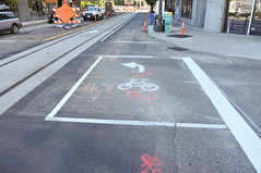
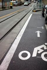
“Copenhagen Left” (instead of crossing new
streetcar tracks at a dangerous angle).
(Photos © J. Maus)
The Portland Streetcar Loop Project has brought major changes to bikeways in the Pearl District. With new tracks, new medians and a new recommended route for bikes, PBOT has released a detailed list about what changes people on bikes can expect.
“These changes will alter the cycling conditions in the vicinity of the west end of the Broadway Bridge and require that all travelers in the area be aware of new signs, lane markings, street and signal configurations and streetcar tracks.”
Here’s what you can expect at the west end of the Broadway Bridge (taken from PBOT press release):
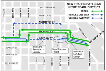
- NW Lovejoy between NW 13th and 10th is a one-way, eastbound street that is closed to vehicles traveling westbound from the Broadway Bridge.
- NW Northrup between NW 10th and 16th is a one-way, westbound street.
- NW Marshall between NW 9th and 16th is a two-way street with a new bikeway that is the preferred route for cyclists accessing the west end of the Broadway Bridge. Improvements to the street include the addition of sharrows (shared lane markings), asphalt pathways in areas with cobblestones, and bicycle wayfinding signs and pavement markings.
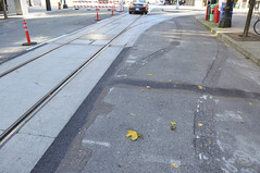
- NW Lovejoy between NW 9th and 10th has multiple streetcar tracks that present obstacles to cyclists.
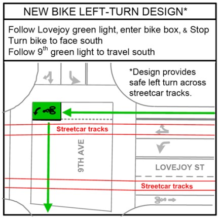
- A new “Copenhagen Left” turn box on NW Lovejoy at NW 9th is for cyclists traveling westbound from the Broadway Bridge turning southbound on NW 9th.
- The bicycle lanes on NW Lovejoy between 9th and 13th Avenue have been removed.
- NW Johnson between NW 14th and 9th will have shared lane markings for cyclists (sharrows) installed in the near future by the City.
If you’re headed west from the Broadway Bridge:
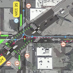
- To access the new bikeway on NW Marshall, cyclists must turn right at NW 9th while yielding to pedestrians in crosswalks, travel one block north while transitioning to the new shared left-turn lane, and then turn onto NW Marshall. See diagram of NW 9th below for details.
- To access the bikeway on NW Johnson and points south, cyclists should use the new “Copenhagen Left” turn box on NW Lovejoy at NW 9th. To do this, cyclists are advised to ride through the intersection to the green box in the northwest corner, stop there and reposition their bicycle to face southbound, wait for the traffic signal on NW 9th to turn green for southbound travel, and then go.
PBOT has also provided these diagrams for your convenience:
I was out at the site today. Suffice it to say these new tracks and changes to Lovejoy will definitely take some time to adjust to. More reporting to come…
If you have questions or concerns, direct them to Kay Dannen of Portland Streetcar at 503-478-6404 or via email at dannen [at] portlandstreetcar [dot] org.



Thanks for reading.
BikePortland has served this community with independent community journalism since 2005. We rely on subscriptions from readers like you to survive. Your financial support is vital in keeping this valuable resource alive and well.
Please subscribe today to strengthen and expand our work.
I just want to take a moment to celebrate the retirement of the “bike lane through the streetcar stop” feature at 13th and Lovejoy that probably should never have been.
Yeah!
Also, I don’t think the diagram quite does justice to the bikeway network in the area. It suggests that folks on bikes should return to Lovejoy westbound at 15th. We actually have several other great bike boulevards that go east-west:
Marshall goes as far as 22nd, Johnson goes to Westover and Overton goes to 25th. They are all much nicer to ride on than Lovejoy.
Can someone please explain to me how the streetcar fits in to a comprehensive transportation strategy? Is it intended to replace the bus? Is the huge cost of required infrastructure worth it in any way? I have to say the idea that the streetcar development should take precedence at TriMet to a fully funded bus program out of the general fund (this is why the bond was so important remember) seems ridiculous and shortsighted. Streetcar tracks are a hazard to bikes and outside of a misguided sense of nostalgia, I can’t understand why this program exists. Lovejoy has gone from being a convenient and effective bike route to a nightmare of tire trapping tracks. All this so empty streetcars can toot around and look quaint? I’ll believe TriMet is serious about getting it’s budget under control when they kill the streetcar program.
NW Marshall stinks west of 14th, it’s full of people in motor vehicles rushing to their doctor’s appointments at Good Sam Hospital; entrances to both hospital parking garages are on Marshall.
I’ve debated the value of streetcar here many times and don’t particularly want to do it again. I will just correct one misperception from #3: Streetcar is a City of Portland project, NOT TriMet. TriMet contributes operational funding roughly equivalent to what it would cost to run a bus along the same alignment. The City pays the rest from parking meter revenue. So Streetcar does not drain operational dollars away from buses.
We can debate where the best place to spend capital dollars for transportation is. I’m already on record that I would fund bicycle infrastructure ahead of rail infrastructure if there were no other constraints.
I look forward to the day when the Federal government has a “Federal Bicycle Administration” with resources equivalent to what the Federal Transit Administration has to offer to match local expenditures (even better, let’s get the same resources as the Federal Highway Administration!).
Thanks for the clarification #5. I’ll take my vitriol out on the city. Of course it raises an even deeper issue as to why two major mass transit systems aren’t organized and managed collectively. One upside to the upcoming budgetary shortfall for Portland and Oregon government funding is the opportunity to reorganize public works and programs in a more efficient way.
Sigh… I just can’t help myself.
raises an even deeper issue as to why two major mass transit systems aren’t organized and managed collectively.
They are actually very tightly coordinated, but serve fundamentally different missions. TriMet is engaged in LRT to move people quickly across the region. Portland is engaged in Streetcar primarily to create dense, sustainable, livable urban neighborhoods – more placemaking than transportation, even if transit is the tool.
This blows.
So now we are supposed to drop any possibility of carrying speed off the Broadway up Lovejoy, and instead loop around on Marshall?
All so un-needed streetcars can crawl up and down a one way street about as fast as most walk?
At how many million dollars per block?
Once again, this blows, and streetcars blow…….
I know Pbot did what they could, but the real solution was no streetcars.
I know Pbot did what they could, but the real solution was no streetcars.
PBOT wanted the streetcars more than they wanted safe streets for cyclists.
If you think NW and the Pearl are bad, wawit until the eastside streetcar is done, it’s going to be even worse for cyclists.
Thanks for giving in to the temptation Chris. Still, I thought place making transportation was what the bus was for. It’s the overlap I object to. Buses are far more flexible in responding to changes in population, zoning, and movement of anchor employers. Streetcars are permanent infrastructure fixtures that provide the same speed and capacity of movement, without flexibility, and with greater cost. I hate to say it but the only justification I can see for the streetcar program is that it looks neat. I’m pretty sure streetcars are the ultimate entry at Stuff White People Like (but won’t actually use).
I try to not think of the streetcar as a transportation project but rather as a downtown revitalization project. By making it easier for people to get around downtown, it ties the area together and makes downtown more livable by replacing automobiles.
what is the distance from the curb to the side of a passing streetcar as you descend the lovejoy ramp? and actually, ascending looks even narrower.
So,
The reality once again, as has been shown many times before, is that the City et all (including, sorry, Chris Smith, you have seemed to love street cars and tourists most of all) cares more about tourism dollars and politics than they do about keeping it’s own citizens safe on the street.
This happens with the street cars, it happens with the Broadway bike lane (hotel zones), and has been verified as fact actually to me verbally by a forever unnamed source.
Once again,
Big money and tourism is more important to those in power than the lives of those already living here.
Sucks don’t it?
I like how Amsterdam (and others) implements streetcars/trams in the middle of the roadway with separator of sorts, with one lane of car traffic on either side, then a cycle path and sidewalk. The streetcars then basically have right of way and travel very fast. Buses and taxis can use the streetcar lanes as well, but the having everything separated seems to work far better than ours, which have to wait for parking cars, cars waiting to turn right (or left), large vehicles parked too close to the tracks, or on them, etc. The trams in Amsterdam are a very fast way to get around, along with bikes 🙂
#14, the trams in Amsterdam extend service to the residential suburbs as well. They function as a combination of both Max and Streetcar. That’s the lesson I think city planners are missing. That’s what bugs me.
Excellent job, Chris!
You should run for office!
#15: You’re right, but those residential areas are fairly close to the center, and you can get anywhere in the central city by tram and they serve dense business corridors and neighborhoods much like streetcars. The stops are fairly close together, but not 2 blocks from each other like Portland, which is ridiculous. The metro system serves the further out neighborhoods like MAX does, as well as the suburban and regional trains. What’s my point? ha. I don’t know. Cheers.
“Streetcars are permanent infrastructure fixtures…”
that’s why streetcars/rails, electrified buses are placemakers. their permanence. they are set on that route. bus routes can move. or stop.
the “rails are going to get you” hysteria is out of control.
I like the streetcar and use it frequently as it passes a block from my front door. But, I also like coming down from the Broadway Bridge and onto Lovejoy. You can put the stripes and signs wherever you want but convenience will dictate the route I take!
As a lover of all things perverse in cycling, Chris, I thought that running a bike lane smack dab through the middle of a streetcar platform was a stroke of absolute genius!
1. F*** Amsterdam.
2. I’m fine with rail, but not on the public streets in such a way that it competes for space with cyclists the same way the buses do, except with the extra hazard of the rail flanges.
3. The new hazards at the east end of the Broadway Bridge, where the bike lane at N. Larrabee is now curbside of right turning trucks, is also courtesy of the streetcar, NO THANKS!
BURR: Amsterdam rules. Portland has nothing on that city. Sorry 🙂
Screw this. I’m making a bike that rides the rails.
I allways fealt the street car project was so the rich people in the lofts could have a fun way to get to the Blazer games, buses are too scary for them. Think about how many rich people live where the trolleys are compared to the poor areas where the buses are. It will be a long time before they make a trolly into st johns
@ Paul #22: Portland isn’t Amsterdam and never will be. If you want Amsterdam, you should move there.
I’m not so sure that I agree with this idea that the streetcar is so much more dangerous than a bus. If you go down on the tracks you might break bones, but I know exactly what direction a street car is going to go at all times, there is never a chance of it suddenly turning or changing lanes into me and crushing me to death beneath it. I guess I am willing to make a trade of a few more slight injuries for fewer deaths and I think from a severe injury/death point of view the streetcar is actually safer. Chris might have some data to tell me if I am right.
@ bjorn, that is a really good point. Streetcars have the advantage of being totally predictable – unlike buses, cars, delivery trucks, bikes, and peds – and also relatively slow-moving, unlike max. So while the tracks might get you, it’s likely only once, while other vehicles can get you anytime, anywhere.
Thanks Chris for all your hard work to make Streetcar one of the most successful projects in Portland…ever.
Its a model…local money both public and private creating a new piece of infrastructure that has transformed the west side of the Central City.
Maybe LIDs is a way to fund real Bike Boulevards and corridors.
For me, biking with it and around it is no big deal. Of course getting used to new tracks, new traffic flows and such around NW Lovejoy will take some getting used to.
I like the new street car route. Maybe I’ll just ride it up the bridge to the east side so I can avoid that sweating climb.
But the idea of having to make a left and wait for a light, it is going to be really unpopular amongst many bicycle commuters.
mel-yel (#23):
here’s where to get some rail bike plans if you need ’em:
http://rrbike.freeservers.com/#Bentley_RAILBIKE_Plans
As of this morning, the new One Way signage on Lovejoy and Northrup are virtually non-existent. Needless to say, I’ve seen many confused drivers and cyclists going the wrong way.
Just waiting for the crunch of metal…
I know who doesn’t like the streetcar…people who don’t use it. I lived in NW Portland for 3 years and used it All. THE. TIME. Especially in the soggy wet winter. Especially because I went to PSU, at the opposite end of the trackline from where I lived (23rd/Overton). Especially since it goes by bars & restaurants throughout downtown.
The streetcar was over 50% full 75% of the time, morning midday, evening or late night. Often it was at capacity, making you squeeze in super tight like Japanese subways. My only complaint was that it turned off at about 11 or 12 but the bars don’t close until 2.
Bike on the dry days, streetcar on the wet days. The gas in my car went bad while I lived in NW because I could bike or streetcar EVERYWHERE I needed to go.
in regard to skodt (#32)it would be interesting to know if there are any user studies on why streetcars seem to be far better at attracting riders than a bus; it’s clearly not the speed. Quality of the ride? No need to interact with the driver?
Clarity of route?
Chris?
My daily commute involves crossing the Broadway Bridge and then turning left (south) on 9th Ave. I absolutely hate hate hate the “Copenhagen Left” box and there is no way I’m going to use it. I guarantee that bikes who stop there will be getting hit by other cyclists continuing straight west on Lovejoy. And, considering the slope of the descent from the bridge, some of these collisions are going to be at a high enough speed to cause some real injuries.
When I first saw the paint go down for that box after the bridge re-opened to bike traffic I thought “wow, what a stupid idea. I hope it’s just for while they are doing construction here in the intersection.” Sad to see it’s actually part of a “plan”.
I will take my chances angling across the streetcar tracks and turn from the left “real” turning lane, not skid to a stop in a little box, straddle walk/rotate on my bike to face south and hope that I don’t get clobbered by someone coming down behind me.
So Lovejoy is one way between 10th and 13th but not between 9th and 10th? How does that work — it seems really bizarre to have one block of two way, three blocks of one-way, and more two-way. While Northrup is one way until 16th?
And they’re suggesting taking 15th from Marshall to Lovejoy, even though 15th has parallel tracks and Lovejoy has an awkward track crossing between 15th and 16th? Did anyone actually ride this route before recommending it?
This is a serious inconvenience for cyclists in the area. I don’t live up here anymore (just moved, now get to commute over the Hawthorne, thank the little gods) but I still work in the area, and I don’t know what the designers were thinking except “Oh, I guess cyclists won’t mind having to go several blocks out of their way to access everything in this area, including the many businesses on Lovejoy.”
You have to turn out of your way whichever direction you’re going. Marshall is full of stop signs and doesn’t connect to NW 23rd. Johnson and Overton are fine (although Johnson also has too many stop signs), but both are noticeably out of the way if your destination is on Lovejoy.
They really missed an opportunity here to make Lovejoy/Northrup into a nifty one-way couplet system with bikeway room. The result is just plain irritating.
Streetcar fail, PBOT fail.
BURR: What’s wrong with taking good ideas from other cities? You made a complaint about the failure of our streetcar design and I pointed out an example of great implementation from my own experience. We shouldn’t be too proud to look outside our city or country. I once lived in a city with 30 tram lines and the system was awesome. It would be worth looking at why it works so well in those cases and try to emulate their success.
As far as moving to an EU country, it’s not as simple as just moving there for someone without an EU passport. I went to school there and would love to move back though.
I took a trip out there midday to see it up close, and I’m concerned the final configuration will lead to many conflicts.
I love left-turn boxes, but this one is placed incorrectly, smack in the middle of the bike lane. I understand that this is supposed to be a dead-end for cyclists on Lovejoy, but I didn’t see anything that was going to stop those that wanted to go straight through.
Either they will collide with the cyclist waiting in the box, or they’ll merge into the streetcar tracks at a tight angle – the exact problem they were trying to solve with the box in the first place.
If they really want the box, they could move the pedestrian crossing 7ft north, and place the box in that space.
I think the scariest thing about this new alignment is that much of the auto traffic coming westbound down the Lovejoy ramp is going to be turning right onto NW 9th now, presenting the perfect storm for lots of right hook collisions.
The best way to deal with this SNAFU will be to get in the lane between the rails at the top of the ramp, and continue in the lane between the rails west on Lovejoy.
it would be interesting to know if there are any user studies on why streetcars seem to be far better at attracting riders than a bus
No, but there is empirical evidence. Metro has a model that predicts how many people will use a given transit line. It pretty accurately tracks with TriMet’s actual bus ridership. But you have to multiply by something like a factor of 1.3 to make it correctly model streetcar ridership.
There are a lot of theories on why this, I don’t know of any research that tries to weight which factors are strongest:
– quieter
– smoother ride (doesn’t rock when pulling over to the curb)
– track makes it clear where the line is
– no diesel smell
– 3 doors for boarding vs. 1
– signs at every shelter telling you when the next vehicle is coming
I could go on…
P.S. I agree with all the comments that 15th is a lousy place to suggest for cyclists to come back to Lovejoy. 16th, 17th and 19th are all much better choices.
I think the scariest thing about this new alignment is that much of the auto traffic coming westbound down the Lovejoy ramp is going to be turning right onto NW 9th now, presenting the perfect storm for lots of right hook collisions.
The intent of the design is for auto traffic to turn right at 10th. The idea was to take the bikes right at 9th, so they could cross the stream of auto traffic perpendicularly at 10th and Marshall, rather than trying to cope with two sets of rails and auto traffic at 10th.
I walked around the project today, observing workers applying green street stuff. Rails are really neat, especially the artistic cross-over and swing-back for the right turn from Lovejoy westbound onto 10th northbound.
It is tough to figure out the rationale for car and bike traffic, though. It baffles me just what was gained by making Lovejoy one-way eastbound for a few blocks: it seems only a major blockade, and one-way streets always generate more traffic, which scarcely is a good idea an an area as compact as the Pearl.
Sure enough, a cyclist was riding west–wrong way–in the right lane, against auto traffic on Lovejoy. I’ll give it a shot on the bike next week–right way–and see how it works.
I am glad this time around, Streetcar and PBOT attempted to do bikeway mitigation here.. and really, we should continue to push Streetcar to come up with a serious budget line for this in future streetcar projects. To me, when streetcar goes in, this is the perfect opportunity for some serious infrastructure to go in as well, like a cycletrack, bike signals, pathways, etc.
I know funding challenges make that a non-starter, but I’d like to see Portland push for these improvements, and do it when the pavement is being torn up, and the roads closed, not piecemeal it in afterward (i.e. Broadway or Burnside/Couch).
Until then, those of us traveling by bike will continue to be redirected to out-of-the-way detours. We should do better!
I love the streetcar and my bike–the problem isn’t the streetcar we just need better bike infrastructure. Some of the comments here sound like the comments section on The Oregonian where folks complain about the “terrible” streetcar at the drop of a hat. Also FYI it isn’t “empty” I ride it at rush-hour and it’s packed.
“To do this, cyclists are advised to ride through the intersection to the green box in the northwest corner, stop there and reposition their bicycle to face southbound, wait for the traffic signal on NW 9th to turn green for southbound travel, and then go.”
Try this with an extracycle, tandem, recumbent, touring bike, bakfeits, when towing a trailer or even a standard bike loaded with books &/or groceries.
As for the streetcar, it seems that since much of the route is in fareless square, this contributes to overcrowding. I wonder what proportion of passengers pay $2:05 to ride beyond fareless square…
“To do this, cyclists are advised to ride through the intersection to the green box in the northwest corner, stop there and reposition their bicycle to face southbound, wait for the traffic signal on NW 9th to turn green for southbound travel, and then go.”
Try this with an extracycle, tandem, recumbent, touring bike, bakfeits, when towing a trailer or even a standard bike loaded with books &/or groceries.
This configuration is known as a “Copenhagen left” after the city it is borrowed from. My understanding is that various forms of cargo bike are quite common in Copenhagen, so I assume there are ways to work it out. If the bike box is not correctly sized or positioned, I believe PBOT/Streetcar will be happy to look at suggestions to reconfigure it.
As for the streetcar, it seems that since much of the route is in fareless square, this contributes to overcrowding. I wonder what proportion of passengers pay $2:05 to ride beyond fareless square…
The entire extension to the east side will be outside fareless square, so we’re going to find out 🙂
But isn’t that sort of like saying Portland’s bicycle counts are inflated because we don’t charge a tax on biking?
The part I was questioning was the “stop there and reposition their bicycle”, which would require lifting or dragging the rear end. When I cross tracks that I am riding parallel to (or between), I feint to the opposite direction that I want to turn (while in motion) and then turn so that I am crossing at an angle closer to perpendicular.
Repositioning of one’s bicycle needs to occur prior to stopping, so the bike lane should deviate to the right before entering the green box.
It was in fact in Copenhagen that I first contended with trolly tracks and wet cobblestones while riding a loaded touring bike. It wasn’t a very bike friendly city back then (1968), although they did already have the seminal pedestrian street, “Stroget” through the center of the city.
I do appreciate that Portland’s planners are trying to accommodate the needs of pedestrians, cyclists and transit passengers while somewhat deemphasizing driving. I look forward to a time when they will create some car free streets (and prove the merchants wrong).
I wasn’t alluding to the passenger count (although I’m sure the fareless rail-square skews the numbers), but the fact that a paying passenger attempting to board at say the Galleria to go to NW 23rd has to contend with a crowd of mostly free riders who are only going a few stops – some of whom no doubt go further w/o paying (since there is I gather no penalty other than being asked to disembark if caught). A nominal (50 cent?) fee for everyone might alleviate this) – but that was an aside, not relevant to cyclists or this discussion.
Roger, I’d love to see a drawing (and I suspect PBOT would be interested as well) of what you’re suggesting.
Streetcar’s surveys should that outside fareless square 70-85% of riders do in fact have a fare instrument. Often it’s a pass or a transfer already in their pocket so you don’t see them buy a ticket when they board. But my point was that saying “too many people are using transit because it’s free” is kind of silly 🙂