Last week, Metro Council approved funding for the South Waterfront Transportation Management Association (TMA). The new TMA will be funded to the tune of $300,000 (half from Metro, other half matched by neighborhood businesses and residents of the area) over three years and is set to begin work on July 1st. Other supporters of the new TMA are developers, the City of Portland, the Portland Development Commission, and Oregon Health Sciences University (OHSU).
TMAs are non-profit, public/private partnerships funded through the federal government’s CMAQ (Congestion Management/Air Quality) grant program and administered through Metro’s Regional Travel Options program. The idea behind them is to increase awareness and promote the use of biking, walking, ridesharing, and taking transit. Or put more simply, discourage single-occupancy vehicle use.
This will be the sixth TMA in our region and the first one created since 2001. Other TMAs currently exist for the Lloyd District, Clackamas, Swan Island, Gresham, and Washington County.
In a statement about the new South Waterfront TMA, Portland Mayor Sam Adams said it will “help residents and businesses with transportation choices so congestion and pollution don’t jeopardize the potential of the district.”
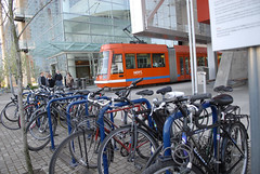
According to Metro, the new TMA already has a list of projects it hopes to get started on. Among them are increasing bike parking (which a recent report showed can be good for neighborhoods and businesses) and working with the City and other stakeholders on the Milwaukie Light Rail and Lake Oswego Streetcar projects.
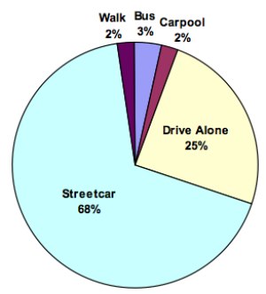
A recent survey of South Waterfront residents compiled by the City of Portland showed that 83% of respondents (86 people took the survey) make at least 3 trips into downtown (about two miles north) from their condos each week. Below are results from that survey when asked how they get there:
What is your primary mode utilized for accessing downtown & Central City?
What is your secondary mode utilized to access downtown & Central City
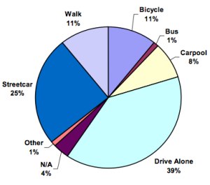
If all goes well, the TMA hopes to decrease vehicle miles traveled in the district by 30% by 2030 (as per Portland’s Climate Action Plan and myriad other city and regional plans). It will be interesting to see if those percentages in the charts above change after the TMA has been in operation a few years.




Thanks for reading.
BikePortland has served this community with independent community journalism since 2005. We rely on subscriptions from readers like you to survive. Your financial support is vital in keeping this valuable resource alive and well.
Please subscribe today to strengthen and expand our work.
Excellent news! The contribution that South Waterfront bike commuters make to the local economy, healthcare, etc. is pretty huge.
It seems a little silly to drive when there’s a dedicated light rail line built specifically for your condo. I don’t know how much more convenient it gets. I guess I don’t know the context of the trip.
Maybe I’m out in left field all alone on this, but every time I hear about the Lake Oswego streetcar project I cringe. Why? Two reasons. First, I’m told the existing tunnel through the hill in the rail right-of-way is not wide enough to accommodate both a streetcar and a multi-use pedestrian/bike path. So if you like the idea of a path that ties into the new Sellwood bridge and that runs south along the river to Lake Oswego and Tryon Creek State Park, the streetcar would essentially kill that. The second reason is that I don’t see the cost-benefit for long streetcar trips. It’s too slow for longer trips, not like the faster light-rail system, and I don’t foresee big enough ridership numbers to justify the significant cost per rider.
On the other hand, a multi-use path could provide a beautiful linear park along the river, cutting out some of the worst hill climbs and providing a dynamic cycling and pedestrian link between Portland/Sellwood and Lake Oswego/Tryon Creek I hope that option is still on someone’s table.
I’m not trying to defend those that drive to downtown from SoWa, but the street car is so very very slow. And until recently it was the only public transit option into this area (other that the tram).
On days that i don’t ride to work, if i take transit, it takes 45-60 minutes. That’s a 10 minute bus ride, and the rest involves the streetcar. (And i can make the walk in 30 min!).
But I agree that this is great news!
South water front can be a great route if they ever link Lake Oswego. Immediately they could get R&H Construction to keep the Bike Lanes clear of debris. 2 Tires this month thanks to nails and construction trash.
The streetcar is painfully slow. It does not have enough dedicated space and must fight with traffic.
I ride my bike through south waterfront daily from the Hawthorne Bridge to the Tram to get to work. Recently, they painted big, bold, bright sharrows on the streets around Riverplace. I’ve noticed cars are generally more friendly to bikes, and it feels easier to take the lane. I’m looking forward to more improvements.
RonC: A streetcar is designed to travel up to 40 MPH. For those long stretches between Lake O. and South Waterfront, they could put the pedal to the metal and make some good time.
BUT, streetcars today do not have bike racks inside. They are designed for passenger use only. We’d have to add bike racks inside for that route if bikes are to be allowed on a streetcar.
RWL1776: Unfortunately a theoretical top speed of 40MPH does not mean a streetcar would average that speed. I’ve gone up to 48MPH on my bike, but I’m not going to average anywhere near that on a ride (rats!). Dunthorpe residents will demand a limit on speed though their backyards, and my take on the typical commuter from Lake Oswego is that many are time-crunched and convenience driven people. As a LO resident myself I’m not dissing LO folks here, just stating an observation. For me, it would be more convenient to have a bike path rather than a streetcar. I’m not saying cycling would be faster. But it might not be much slower, factoring in getting to the streetcar stop, waiting for the next streetcar, and coming in through Dunthorpe, John’s Landing, SOWA, and downtown. A multi-use path/linear park gets my vote, as it would really link-up the existing cycling infrastructure nicely, and serve commuters and recreational users alike.
If you’re going to put in a streetcar, then a connection (with bike provisions) between LO and downtown Milwaukie, across the existing rail bridge, makes more sense. It could tie into the future Milwaukie light rail line, and provide another needed connection across the river. That would preserve the rail right-of-way on the west side of the Willamette for a multi-use path and linear park.
Why did they only survey the residents there? I’m sure that when you go down there most any work day most of the cars on the road do not belong to the residents there but to the people working there. I don’t think that the alternative transportation is going to work out for them at all. This sounds like a poorly thought out survey that achieved unreal results.
Jim brings up a good point. The 11% for secondary commute is encouraging, but the main contribution the area makes to Portland is as a work destination–not a residential destination.