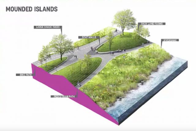
(Graphics: Sasaki via Portland Parks & Recreation)
The City of Portland is in the latter stages of a master plan update process that will decide the fate of the northernmost section of the South Waterfront Greenway path. Last week Portland Parks & Recreation released three of the design concepts in a presentation given by project consultants and now they want to hear your feedback.
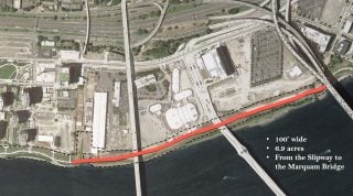
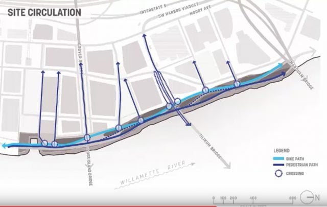
You might recall that a major portion of the new path was completed in March 2015. The “North Reach” of the greenway consists of about four-tenths of a mile between the end of that existing path (at around SW Gibbs Street and the Zidell barge-building warehouse) to the Marquam Bridge.
With all the development in this district and the big plans for the waterfront recently unveiled by Zidell Yards, this is an exciting opportunity to create world-class public space that will double as an important cycling route along the Willamette River. (For more on how Zidell’s plans will impact path construction see our story from September.)
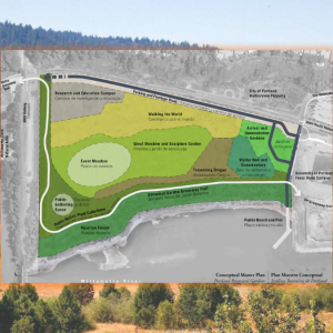
Portland Parks & Rec shared a presentation via YouTube from the project consultants on December 27th. Here are the main highlights of the three concepts:
“Bursts”
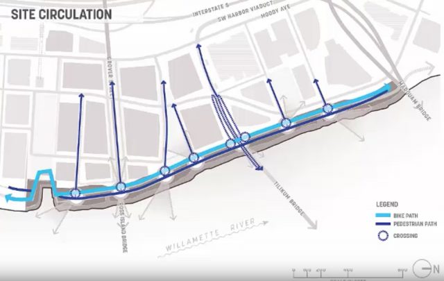
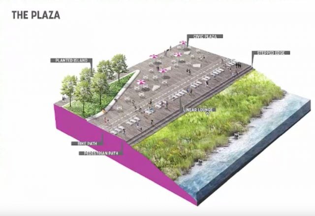
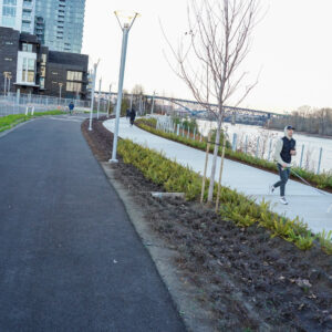
This concept would distribute public plazas evenly across the new path and orient people toward specific views (Mt. Hood, downtown, bridges, and so on). Like the new section of path to the south, the cycling and walking paths would be separated with people on foot being closest to the river.
Advertisement
“The Braided River”
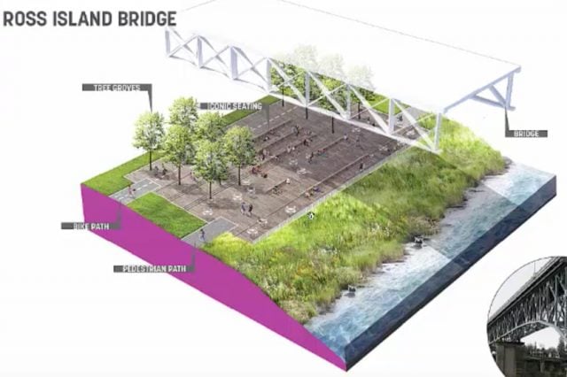
Taking its name from the natural flow of our region’s rivers, this concept would put most of the public spaces toward the south near Ross Island. The biking and walking paths would still be separated but they would undulate more organically than in the “Bursts” concept.
“The River Terraces”
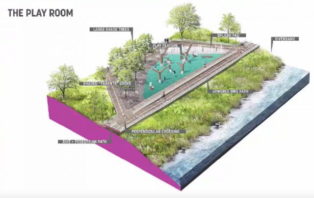
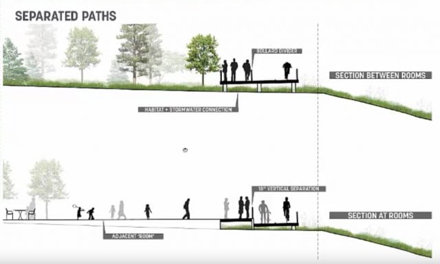
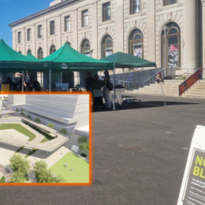
In this concept the biking and walking paths would be on raised boardwalks which would allow for a more connected natural landscape. In between plazas the paths would be on the same level and separated by some type of physical barrier. When going by a plaza space, the bike path (which would be closest to the river in this concept) would drop about 18 inches below the walking path.
In each of the concepts the designers say they will go to great lengths to connect the riverfront path to adjacent streets. Getting people from the path up to the Tilikum Bridge is another important consideration yet to be ironed out. After hearing public feedback on these concepts, planners will refine the alternatives and make a final recommendation. Construction isn’t expected to be completed for several more years.
In related news, a South Waterfront neighborhood group won a $13,640 Metro grant to install 20 bicycle wayfinding signs in the district.
All this news combined with other progress with the path in recent months is adding up to an important time for transportation planning in South Waterfront. If you’d like to get involved, check out the City of Portland’s North Reach planning website.
— Jonathan Maus, (503) 706-8804 – jonathan@bikeportland.org
BikePortland is supported by the community (that means you!). Please become a subscriber or make a donation today.




Thanks for reading.
BikePortland has served this community with independent community journalism since 2005. We rely on subscriptions from readers like you to survive. Your financial support is vital in keeping this valuable resource alive and well.
Please subscribe today to strengthen and expand our work.
Oregonn White Oak trees are needed.
Oaks drop acorns. Acorn shells are brutal on bike tires. Sure it’s a while before they start to produce them, but they will come.
I am beyond skeptical of this claim that acorn shells are brutal on bike tires! Bring on the Oaks, we can handle acorns!
Survive acorn shells with these 30 pearls of wisdom. Story up next.
This looks really cool. I was worried that the extension of Bond Avenue north from the tram would detrimentally affect the riverfront, but after seeing the renders from the Zidell development plan and now this, I’m super excited for what will amount to a second Waterfront Park — reminiscent of Vancouver’s famous seawall.
I don’t like The Plaza concept. Too much of a private pool.
Except public?
I don’t think it is a good idea to use raised walkways for paths. It adds expense and creates unnecessary hazards for no benefit. I also think that the ped path is best located along the river- people will instinctively migrate to the water’s edge and want to linger there- not the best fit for a bike path.
Otherwise, very exciting options
I agree about the placement of the bike path. I like the boardwalk and natural connection concept of the Terraces design otherwise though. One thing I would love to see is some bona fide river access. I haven’t watched the YouTube – was that included in any of the proposals?
The Zidell Yards concept has a substantial river access component. Not sure about this portion.
Have you checked out the new path link that tesla just put in? It’s really nice and wide and with the recent repaving of the path through Willamette Park the greenway trail has never been better! Excited to see the final pieces finally falling into place
Crucial to ensure easy and intuitive cycling links to the tillikum bridge. City blew it big on the east side
They don’t have a clue. How many designs are they floating, six plus? Are they asking anyone what works best for cyclists, or just going for another feather in their ‘design’ cap???
I know cyclists won’t always agree on what works best, but jeez…
When a client commissions a company to do design work for them it is standard practice for that company to offer multiple design options.
I’m glad we get to debate the fine points of some really strong designs, rather than beg for a minimum treatment, like some of these projects in the past. The bar is slowly being raised, at least when there is no car traffic to consider. I’m really happy to see separated foot- and bikeways.
“Like the new section of path to the south, the cycling and walking paths would be separated with people on foot being closest to the river.”
In theory at least. In practice, people will still walk four wide with their little rat dog on the end of a 25′ retractable.
Super low resolution. I can’t really tell exactly what I’m looking at, but he gist seems to be a whole lot more assault than is really necessary.
Which is why I never understand the cyclists that cruise at high speeds on the Esplanade and Waterfront.
I don’t see anywhere to offer public comments when I follow the link. Any tips?
It’s critical that the design be realistic about how the park will be affected by homeless camping and that it strive to make all users feel safe on the pathways. To that end, I think that the mounds are a terrible idea. Visibility is key. For that reason, eugene just has to rip out the berms in Charnel mulligan city park and redo the whole park:
http://www.eugene-or.gov/2305/Charnel-Mulligan-Park-Renovation