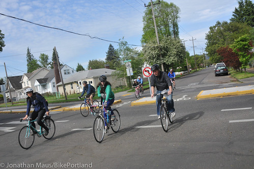
(Photo: J.Maus/BikePortland)
Citing fresh evidence that Clinton Street has accidentally become a significant route for rush-hour car traffic, the Portland Bureau of Transportation last week proposed two diverters designed to push the traffic to Powell Boulevard, Division Street and elsewhere.
Under its plan, PBOT would test median diverters at 17th and 29th to block east-west auto traffic on Clinton while allowing north-south traffic at those intersections. The barriers would be put on the ground this fall and tested for six months.
The city would also make the rules of Clinton’s neighborhood greenway more explicit to people in cars by adding “Bicycles May Use Full Lane” signs to the length of the street from 12th to 52nd avenues. That’d be a first for a Portland neighborhood greenway.
Between Cesar Chavez Boulevard and 52nd Avenue, the city would add speed bumps designed to bring motor traffic speeds closer to the city’s neighborhood-greenway target of 20 mph.
The plan would remove a freeway-style sign on Powell that directs northbound traffic onto 17th despite the official status of 17th as a local service road.
And to further reduce auto traffic on Clinton, the city would follow the request of residents on SE 34th to convert it to a one-way northbound street between Clinton and Division, plus a southbound contraflow lane for people biking. Though this is a narrow local street, it has a traffic signal at Division that tends to lure people south to Clinton. (This change would also function like a semidiverter to reduce through traffic on 34th, which functions as an unofficial north-south bike route through the area.)
The improvements, if built as proposed, would be tested for six months, while the city collects data on how they effect travel patterns in the area. The city will also, no doubt, hear from constituents on all sides of the issue.
What do you think of the plan? You can share your opinion here with the city’s six-question multiple-choice survey.

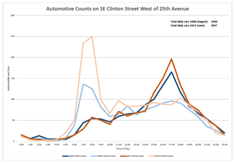
(Graphic: BikeLoudPDX)
For me, one of the most interesting details at last week’s open house was a set of new data gathered by the city that strongly suggested what Clinton users have been saying for more than a year: though Clinton is supposed to be functioning as a local-service street, it’s actually picking up lots of car traffic from outside the area.
“There is a significant amount of non-local auto traffic that uses Clinton as a cut-through route, particularly westbound traffic during the AM peak period,” the city said.
During the morning rush hour, for example, the city discovered that westbound car trips — towards downtown, that is — are five times likelier to be “long distance” than eastbound trips are. It gathered this with sensors that observed the unique Bluetooth signatures from cars as they passed by.
Another tidbit: the city grabbed photos of passing license plates and traced them to their registered home ZIP code. During both the morning and evening rush hours, more than half of auto traffic on Clinton comes from outside the ZIP code, mostly from the south.
Advertisement
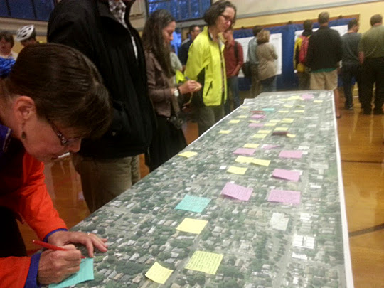
Portlanders who attended last week’s open house about the project had plenty to say about Clinton and the surrounding area:
I talked to several people who’ve been active with BikeLoudPDX, the year-old advocacy group that has focused strongly on getting diverters on Clinton, and they seemed guardedly supportive about the city proposal, which was broadly similar to BikeLoud’s own proposal.
Alan Kessler, a BikeLoud participant who also serves on the Richmond Neighborhood Association, said he was worried about the lack of diversion proposed east of Chavez, where he often rides with his young son. That stretch of Clinton didn’t show up as a problem in the city’s recent study of its neighborhood greenways, though it’s not clear whether the city gathered data there.
An exit-only diverter on Clinton at 50th, similar to the one at Chavez, was one of the BikeLoud recommendations for Clinton that the city didn’t include here. Another BikeLoud proposal, a pedestrian plaza at 26th similar to the one tested last year by Better Block PDX, was listed by the city as part of a possible (but as yet unfunded) “phase two” of changes to Clinton.
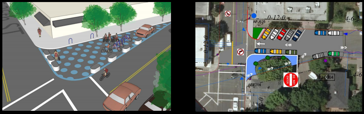
Here’s another intriguing concept mentioned as part of a possible second phase: “special pavement markings” that could increase the sense of place on Clinton and boost awareness of people walking there. I can assume that at least one local business would be in favor of the mockup suggested here.

Though this was just an open house, with attendees focusing on one-on-one conversations about the plan, there didn’t seem to be major fireworks about the proposal when I stopped by last Wednesday. Many people were clearly there to support the proposal; BikeLoud members designed a special flyer to promote the event and created an attractive Facebook event for an organized ride that ended there.
This “ready, fire, aim” approach to new infrastructure, where the city tests something on the street without a lot of preliminary fuss and then adjusts it based on how people respond to it, is growing in popularity around the country. This is PBOT’s first attempt at it, so it could create a new mold for enacting the goals of the city’s new action plan to fix the weak links in its neighborhood greenway network.
That’s why we’ll continue covering this closely over the coming months. Stay tuned.


")

Thanks for reading.
BikePortland has served this community with independent community journalism since 2005. We rely on subscriptions from readers like you to survive. Your financial support is vital in keeping this valuable resource alive and well.
Please subscribe today to strengthen and expand our work.
“Bicycles May Use Full Lane” signs
I would love to see these on all the greenways as a useful reminder for people on bikes and driving. Also would be helpful o North Skidmore between Interstate and NE 7th. Also along NE Prescott. Also on Grand and MLK . Also on SE 6th Ave from Couch to Clay. And on all the streets downtown. And on Mississippi. etc, etc.
While the intent behind “Bicycles May Use Full Lane” signs is good, I fear that their presence would make people believe that right exists only where posted. The law applies to all streets, not just neighborhood greenways.
“Welcome to Portland. Bicycles may use full lane.” Yeah, it’s true outside the city and in most states too.
In my opinion, any “right to the road” for people cycling is wishful thinking.
http://www.oregonlaws.org/ors/814.430
People biking are legally required to ride “as close as practicable to the right curb or edge of the roadway.”
Repeal ORS 414.30 and 414.20!
That rule does not require you to ride closer to the edge than is safe. That means not in the door zone, and, if there is not room for a vehicle to safely/legally pass, there’s no need for you to “tempt” them.
Sometimes, what’s practicable for me is to ride as center of the main traffic lane as I can. That might not be what’s practicable for you, or for someone else, but if the state is going to leave the judgement call of “as far right as practicable” to the person on the bike, then that’s what I’m going to do.
Therefore, I do have a right to the road, and it’s not wishful thinking.
but if the state is going to leave the judgement call of “as far right as practicable” to the person on the bike,”
the state leaves the “judgement call” to law enforcement and traffic courts which always side against the cyclist.
Taking the lane makes you more visible when bicycling, which is safer. I still try to let people pass when I can. But like people said, when bicycling you need to stay out of the opening door zone of parked cars.
When driving on Clinton, I try to pass at a reasonable speed and good distance from the bicyclists, and when there are no oncoming cars or bikes.
Do you live on Clinton?
Agree with Soren here, Otis. Bikes may not always and definitely use full lane with the as “far right as practicable” clause. Now, when that “practicable” is in the middle of the lane, so be it. Which is why it’s actually helpful on narrow streets or lanes to post the “bikes may use full lane” signs.
This is another potential tool, like sharrows, that the city is going to devalue by using it only on neighborhood greenways, rather than on arterial streets, where it was initially intended to be used.
How does reminding people driving to watch for people biking devalue the marking or signing?
How does putting signs and markings everywhere increase their value?
How does putting road sharing signs and markings on road space not meant to be shared keep people biking safe?
PBOT has abrogated their original promise to use sharrows on arterial streets once they were adopted in the MUTCD. Thus far, by and large, they have only allowed their installation on neighborhood greenways.
I see them going down the same path now with ‘Bicycles Allowed Full Lane’ signage.
Furthermore, neither of these types of markings or signage seem particularly useful to me on neighborhood greenways, whereas they could have tremendous value on arterial streets, particularly where riding on those arterial streets is necessary to close gaps in the neighborhood greenway network.
I’ve gotten far more grief riding in the lane on Clinton than I have on Hawthorne or Division.
Finally!
I would like to see these greenway diverters in use before I get gentrified out of the neighborhood.
One or two rides will be good.
Has Ankeny gotten its “coming soon” diverter yet or just more luxury housing?
http://bikeportland.org/2014/12/24/southeast-ankeny-15th-may-get-new-diverter-spring-city-says-123223
Gold mines and shafts.
It was put on the backburner due to the Greenway report but I’m told it’s funded…
funds went to Clinton.
Roger mentioned at the open house that there was funding allocated for diversion on Ankeny…
… and it went toward the squeakier wheel.
there will be more diversion, paikiala.
“the advocacy group that organized last year largely in support of diverters on Clinton”
Diversion on Clinton was one of of BikeLoudPDX’s original advocacy goals but the group was organized due to the the perceived lack of grassroots bike advocacy in Portland. BikeLoudPDX has also advocated for diversion on Rodney, Ankeny, and Lincoln-Harrison. Other ongoing campaigns focus on speed enforcement, equitable funding for “safety” improvements, bike share, cycling crash reporting, protected bike lanes, and the development of an east portland greenway loop/network.
That’s fair, though I don’t think there’s much question that Clinton has been the No. 1 focus of BikeLoud so far. I’ll find a rephrase.
I’m not sure that’s entirely accurate actually, though I understand that’s probably the external perception. Safer Clinton deserves most of the credit in my mind (while there’s a lot of overlap) and a lot of Bike Loud energy recently has been directed towards Livable Streets.
Basically, from outside you mostly hear about Clinton because that’s the hotly focused item for everyone biking in Portland right now.
From inside, yes, Clinton is something talked about a lot, but it’s given equal attention with three or four other issues at any particular moment.
So (for example) the rally for the Greenway Report wouldn’t have qualified as directly Clinton related, except that in the actual politic of it all it _is_ directly Clinton related, so everyone assumes that this is part of BikeLoudPDX’s grand Clinton strategy when really (I’d argue, though I don’t speak for the group and am speaking pseudo-anonymously, etc.) our motivation was simply “We need to support Greenways in this city.”
As a daily Clinton rider, I am very happy that PBOT is finally taking the steps to make cycling comfortable again. They did a great job listening to riders and engineers and using personal experiences combined with data-based evidence. Also, good on them for removing the proposal for the westbound diverter at 12th that serves no purpose for people riding bikes. Really hoping that a permanent Better Block at 26th and Chavez-style diverters at 50th will be part of Phase 2.
Can’t wait to get the diverters on the ground!
This is all great news, though it puts more fear in my heart that SE 26th is tacitly being left to be the traffic sink or goat of the neighborhood. I worry all this good stuff will push yet more drivers onto SE 26th, and we’re seeing a huge increase in way-too-fast traffic here daily. I beg my neighbors and bikeportlanders to fight for SE 26th’s livability too, and to not forget about it/us.
This is a true neighborhood street, lined with homes and with countless schoolkids, parents with strollers and dogs and elderly residents trying to cross it daily, which has become more and more of a challenge as it’s being allowed to turn into an unchecked speedway. There are no crosswalks, at present. No traffic calming, no obvious posted speed limit signs, even. I have never seen a traffic cop.
I spoke to a parked (non-traffic) cop outside my house today, making his shift notes (leapt at the chance) and asked him if he’d please park there every day as traffic behaved much more nicely with him in view. 🙂 I asked if there was a speed limit posted anywhere on the 26th between Clinton and Powell, ’cause I’ve looked in vain for one. He didn’t know but he said the speed limit should be 25mph. Hahahahahahahhahahahahha. People are routinely driving 40-50mph right now. Think of how pleasant it would be if everyone drove 25mph.
The problem (besides neglect) is poor design. It’s a horribly designed virtual dragstrip from Taggart to Powell, and drivers/motorcyclists love it. What with morning and evening rush hours, school rush hours and the popularity of the new attractions on Division, we’re getting hit awfully hard at all hours of the day until well after midnight.
Apologies for the digression, though I do see SE 26th as part of the Clinton greenway improvements, so it’s a bit germane. I’m just getting more and more fearful, what with the recent talk from ODOT and even people here on bikeportland, that SE 26th is getting thrown under the bus…and the freight trucks, and the commuters, and the nightlife trendies.
The glass bottle I had hurled at me by an angry driver at 27th & Clinton annoyed I was slowing her progress one evening scared me from biking on it again for a long time. Happy to hear about the diverter here!
You should never be afraid to defend yourself against assault.
You very well captured my thoughts on the issue. Clinton is only a part of a system that is tremendously dysfunctional. I don’t really care if the N/S route to Clinton is 26th or 28th, but a dedicated and safe route needs to be in place between inner SE and down town. FWIW I was run off the road onto a sidewalk at one of the smaller traffic circles in Ladds Edition. The whole system is being undermined by aggressive, impatient and bad drivers.
Agh! Glad you’re ok, Granpa! As for me, I do care about whether it’s 26th or 28th, at this point, because all the traffic calming that’s happening around SE 26th seems to just be dumping traffic on our little not-built-to-be-a-high-traffic-street and no one seems to consider it a priority, which makes me worry it’s gonna be a sacrifice.
When the SE 21st speed bumps went in, guess where drivers went? SE 26th. With MAX causing even more frustration for drivers on SE 11th & 12th, where will they go? SE 26th. We are getting so much increased traffic from trendy Division Street-seekers, morning to late at night, and commuters and freight trucks are routinely zooming through our neighborhood at close to double the speed limit (25mph, the officer told me).
I still don’t understand what happened. Didn’t I read once upon a time that the 20’s Bikeway project meant for SE 26th to be a greenway with widened bike lanes and traffic calming? What the hell happened to that plan?
When the speed bumps went in on 21st, volumes (on 21st) didn’t decline at all, so I doubt a huge amount of traffic diverted to 26th.
Unfortunately, 26th cannot have traditional “traffic calming” because it is a collector and an emergency response route.
That does not mean, however, that things cannot be improved. I believe we can advocate for crosswalks and other things that 1) make crossing safer, and 2) advertise to drivers that there are people about on the street, so they’d better slow down. Every bus stop should have a crosswalk (N and S of Powell), and there should be one by CHS. Add curb extensions for the win.
Agree with all these traffic calming suggestions, Hello! A simple, obvious posting of the speed limit would be a good start. And a visible traffic cop. It was hilarious how well-mannered drivers were when they spied that cop parked on the side of the road yesterday. I don’t think I’d object so much to the heavy use if people didn’t go so ridiculously fast. The speed of some big trucks on SE 26th is really egregious. Nobody’s driving like it’s a neighborhood and nobody seems to be discouraging that kind of driving.
Posted speed limits:
Northbound on 26th a) N/Kelly B) N/Taggart
Southbound on 26th a) S/Division B) N/Taggart
Are they obscured or easy to see? I certainly never noticed them (and judging by the speed of drivers on the road, neither do they)? When I get home I’ll take a little walk.
At taggart the northbound one looks to be completely hidden behind a tree. Southbound isn’t much better. Didn’t have a camera when I rode by so here’s streetview.
http://imgur.com/a/5vaOv
Thanks, lop! Very helpful. I would say “obscured” and definitely not easy to see.
Anyone bother to call 823-SAFE? I have not witnessed the signs.
Excellent suggestion, paikiala! Wasn’t aware of that number. Will do it. I did call the Traffic Division and left a message but no one has returned my call yet.
The speed limit on 26th is 25MPH. I agree, that seems to be pretty much ignored.
I can testify to that.
Rachel,
26th is a neighborhood collector street. it is supposed to have more traffic on it.
Hi paikiala. I don’t think it was ever made to “collect” the amount of traffic collecting on it now! Are you then against efforts to make it less of freeway and freight/commuter route through the middle of a residential area w/ tons of kids, cyclists and neighbors who have to cross it, daily? I’m not sure what your comment means, otherwise. You ok with it–and the unhappy neighbors living on it–shouldering the burden so that all the other streets and neighbors can be happy, traffic-free and green? Like the wretched child in the basement of The Ones Who Walk From Omelas? This is my fear! This is the way the general conversation seems to be going.
p.s. to paikiala–in short, what I meant to say was….what do you suggest an increasingly panicked citizen on SE 26th do to improve the increasingly wretched situation there? It sounds like you work in transportation–what can neighbors do, what can I do, to keep it from becoming the neighborhood N-S (weirdly truncated) freeway? And why is such a truncated route a collector, anyway? Should it be? Edumacate me!
…and by ‘truncated’ I mean how it gets all jiggety at the north end in Colonial Heights, rendering it useless as a ‘collector’, and dead ends in Eastmoreland.
You refer to a road that carries about 8,000 cars a day as a ‘freeway’?
Hyperbole dilutes your credibility.
The collector north of 26th goes east on Lincoln to 30th before heading north again. Why is anyone’s guess. The proposal in the current TSP update is to stop at Division and add a signal at 30th so the 26th/Lincoln segment can be better protected.
Neighborhood Collectors are not specifically intended to be continuous roadways, just connections between Local Service and higher classified streets – many of them start or end in a neighborhood, like NE 111th, NW Thurman, Chavez south of Holgate. District Collector is the next one up, like Burnside, or 33rd north of Broadway, and they tend to go long distances (districts).
Number of cars is not as important for non-Local streets as appropriate use, something more difficult to define and agree on. Portland, wisely I think, does not put a volume number on it’s traffic street definitions. Cities grow and shrink and function of the street is more important than how many people use it.
“Hyperbole dilutes your credibility.” And rudeness, yours, paikiala.
For this little two-lane neighborhood street lined with houses (and I refer to the section between Clinton and Powell) and a school, yes–I consider that way too many cars–though I could deal with the numbers better if people weren’t routinely driving far above the speed limit. Is that a 2015 measure, by the way? And by whom?
I don’t think being upset about the increasing traffic (and the increasing speeding) is worthy of scorn. I can’t quite get what’s motivating yours: do you consider the road’s use and its negative impact on surrounding homes and neighbors not worthy of concern? I remember this street 10 years ago. It may have been a collector but it was not used as it is now. I’ve watched it change. With dismay. That’s anecdotal, yes.
And, it’s like a billion times worse than it was.
(that’s hyperbole) 😉
You have a vivid imagination, reading into printed words emotion.
You accuse me of rudeness and scorn, without evidence.
The most recent count on 26th was from 2013.
Your energy to change how 26th operates might be better directed toward PBOT and the TSP than spent here.
Dear paikiala–you’ve got to admit you’re a bit of pedant where traffic discussions are involved! You clearly have a lot of valuable knowledge to share, which I appreciate. It would go over better and people would thank you for it if it were delivered with a less supercilious tone, that’s all.
That same description works for SE 52nd too. Why do we have arterial routes with no traffic-calming though residential neighborhoods?
Adam,
52nd is not a collector from Division to Powell, it is Local Service.
Why is 26th between Division and Powell a collector? How do you get a street’s designation changed?
http://www.portlandoregon.gov/transportation/63710
Thanks, p!
rachel b, Do I ever agree. I wish that the plan would look at the entire neighborhood’s traffic flow before making changes. Having lived off of Clinton for over 10 years, I’ve noticed an increase in traffic only after the Division Streetscape project was implemented, forcing through traffic off of Division and into neighborhood streets. Once they implement the Clinton diverters, which street(s) will take the traffic? 26th? Woodward? And/or…? I wish the city would stop reacting and start defining the problem and define a sustainable solution for the entire neighborhood.
That is generous-spirited of you, MaryR! And much appreciated. I’m happy for any traffic calming coming to any of our neighbors, but I agree with what you say here, wholeheartedly. At present, we’re just pushing the problem around.
“I’ve noticed an increase in traffic only after the Division Streetscape project was implemented”
Truer words were never written. Like signs you ride or drive past every day that eventually blend into the background, people ‘observe’ changes near them when another event or change occurs nearby. Proximity does not equal causation, and slow changes often lead to significant differences when considered over longer time spans. But it does not mean the change happened ‘overnight’.
As a resident on SE 34th between Clinton and Division, I am breathing a huge sigh of relief! Finally we’ll be able to get our bikes out of our driveway without taking our lives in our hands. Thank you PBOT for listening to neighbors in Richmond.
Please make sure to let Rich Newlands know how you feel on this! PBOT needs to hear often that the neighbors are on board with these improvements.
Rich.Newlands@portlandoregon.gov
OMG, hyperbole a bit?!?!?!?
Come on over and try to get three kids on bikes into the traffic lane while trying to see around two closely parked cars. We’ve had too many close calls (with cars and bikes) because you can’t see the traffic until you actually get into the lane. Biking with kids is stressful enough; when you can’t see the traffic lane it’s even harder.
Sounds like the problem is the parked cars, and not the two-way traffic.
34th has 1250 trips per day and an 85th percentile of 19 mph. Signals are notorious for attracting traffic. Parked cars and narrow roads help slow down traffic.
This is BP. You aren’t allowed to post unless you have narrowly avoided death on your bike in the past week.
Once the “first phase” diverters are installed and there is some push back, it’s essential that users and advocates continue to support these changes. PBOT proposed removal of the full diverter on Rodney due to neighborhood complaints and it was only saved when supporters showed up in force at a follow up open house.
I should also emphasize that the success of the Clinton Neighborhood Greenway project is meant to serve as a blueprint for Greenway traffic calming in Portland. Success or lack of success here will have a huge impact on future projects!
Glad to see this approach. FWIW, I spoke to Mayor Hales at the first Better Block event last year and he said that he thought that PBOT should take more of an experimental approach to solving problems like this. Try something on a temporary basis; if it works, make it permanent and if not, try something else. Glad to see the message has filtered down. Having political support gives PBOT a bit more rein to be innovative.
And this is not really the first time PBOT has done greenways this way. All of the more recent greenways had 2 open houses and went right to construction.
BTW, the license plate data is manually gathered.
Has anyone asked if this is going to cause a large increase in cut-through automobile traffic on Lincoln? Will auto traffic on Lincoln be measured during the trial period?
Much of the morning traffic is cars heading west on Powell who then jog up 33rd, 26th and 17th, to Clinton, and head west on Clinton to 12th and turn north to get downtown.
Lincoln is far out of their way, plus has the diverter at 20th. There may be some shift, but probably not much of the Powell traffic.
Also, Lincoln is hard to access going east. I could be wrong, though.
21st also feeds a huge stream of traffic to Clinton. Look at the numbers in the Lancaster report.
Most of it is through traffic (250 N+S), not just ‘to clinton’ (160).
I haven’t taken my kids up Clinton for more than a year, preferring instead Tibbetts and Woodward. This morning we were nearly TWICE run off those streets! I’m all YAY for Clinton diverters & changes to 17th, 21st, 26th etc but I’m afeared that’ll just disperse more traffic to even LESS suitable streets.
I think Powell is such a poisonous stroad that it’s bleeding venom onto streets about a mile in either direction. Anything between Holgate and Division is dicey, until you get well past the mid-40s.
Maybe a lower speed limit on Ross Island bridge would clear-up some of the congestion?
Boulder tried the “ready, fire, aim” approach and got roasted by the car drivers. Several council members back down…and the project mostly failed. Thankfully, Portland has long been immune to this tactic and is moving forward with sensible traffic improvements.
This will only be true if the elected leaders actually don’t back down.
Just came across this article, about technology that could be extremely powerful in future data collection about the use of bikeways all over town. http://www.sustainablecitiescollective.com/dirt/1104448/placemeter-measures-flow-people-through-urban-spaces
My favorite afternoon aggro driver’s car sports a bumper sticker with a Dalai Lama quote about kindness
My favorite cognitive dissonance auto is the guy whose license plate reads TAO and the SUV has large decals advertising the concealed-carry classes he teaches.
My first long ride on Clinton last Saturday included a car following too closely for about 5 blocks, a van doing same headed the other way, a pickup driver on the wrong side of center looking at his phone, and being stuck behind a car that pulled out in front of me to drive 10 blocks and park again. These diverters will be a good first step.
Looking forward to experimental diverters on sw Vermont, Corbett, Terwilliger, Shattuck, and Sunset.
You seem completely unaware of the street classification system in Portland and what type of roads would even qualify for diversion. Each of the roads you listed are collectors and ineligible for diversion, since their purpose in the system is to collect auto traffic and move it between lower and higher classified streets. Several are also major emergency response routes.
I’m completely unaware of the street classification system in Portland, too. I’m not a traffic engineer, I don’t work for PBOT or ODOT, though I work with people who do and I think I’ll start asking them some questions because if we’re all supposed to know the intricacies of this stuff in order to comment on it here w/out hectoring, I’ve got some work to do! In my own turn, I will expect all and sundry to know Byzantine chant performance practice from here on out. If you fail I will be most put out and force you to sing ison for an entire week. 😉
Name calling is inappropriate.
Agreed!
I’m aware of the classification system. That is also nearly the full list of non-arterial through routes in southwest. What says neighborhood collectors need to cater to high-speed non-local through traffic? Vermont past Wilson is a local service street with a steady stream of cut-through traffic bypassing the light at Bertha+Barbur. Corbett is a local service street south of Boundary and gets heavy traffic (via Barbur -> Miles) that would stick to I5 or Barbur further North with a diverter or two. I would be shocked if 90% of residents and 100% of bikers on these streets weren’t enthusiastically supportive of diverters.
Many of your chosen streets also have traffic calming already installed. The west hills will continue to have issues due to topography, as the assessment report points out. Those few through streets will continue to carry a heavier burden of service (autos, ER, ped and bike) since they are the only streets available. The recent Stephens/Tryon planning effort attempts to figure out how to do more for all modes with the added restrictions present in SW.
The one thing I want to know more about is how Bluetooth is considered an accurate measure of traffic. I did a quick search online and found this snippet of text: “roadside units collecting the encoded MAC addresses of passing Bluetooth enabled devices (phones, earpieces, hands free kits, etc)”. This seems like an extremely naive way to count traffic. The assumption is that every single car driving through Clinton will have something like an iPhone and the Bluetooth is on by default. (Because apparently it is on by default on iPhones). Another assumption is that people actually use hands free devices to talk on their phone. I was downtown waiting to cross Naito this evening and witnessed a women half way into a right turn blocking the bike lane while talking on her cell phone. I would expect a more accurate accounting of traffic. Bluetooth counting is silly and inaccurate at best. Why can’t they simply put down the pressure hose vehicle counters?
I did have a chance to go to this open house. A lot of people put post it notes on that satellite printout of the neighborhood. All of them that I read were good and honest remarks about the street.
I like the sign ideas more than the other ideas. It would be nice if the outcome of all this work is that drivers learn to slow down or avoid the area.
I’m not sure what the precise application of bluetooth monitoring was for this study, but it as probably used to sample travel speed (measured between two sensor points) and for trip distance along the greenway to gauge the level of cut through traffic.
I’d hope they used more conventional measures for traffic volume counts themselves.
Yes, the traffic counts were done with tubes. Bluetooth detectors are mostly useful for speeds and routing, for the reason you mention: lots of people don’t have Bluetooth.
Bluetooth data provides a unique code for each device and that code’s progression and location can be tracked. Only the code, not any identifying information about the device owner. The downside is slow cars look just like fast bikes, so there is no way to distinguish between them clearly.
” The assumption is that every single car driving through Clinton will have something like an iPhone and the Bluetooth is on by default.”
I don’t think that’s the assumption at all. I’m quite confident they are extrapolating statistically–they surely have some baseline data to have a decent correlation of the sample to actual numbers. Moreover, there’s no indication they were using the Bluetooth for traffic counts, only for routes (so if 25% of the bluetooth cars were doing something, they could reasonably extrapolate that to 25% of the total count).
Lastly, bear in mind that nearly every new-ish car on the road these days has bluetooth built into it, and it’s always on.
Sorry, didn’t notice Corey had already said the same thing.
Bluetooth is typically used for origin-destination studies (where are the cars coming from and where are they going?), not volume counts. They only capture 3-8% of vehicles.
My assumption (not working for PBOT, but I have worked in traffic counting) is that they would use a traffic factor, combining short term manual counts with longer term bluetooth counts to get a fuller picture. This is basically how a lot of cities use tube counters too.
It’s a good start! I would still like to see a diverter at SE 50th. All the traffic pours onto Clinton from there to avoid the light at 50th & Division. It’s insane.
The Clinton updates make sense – but we need to realize that as inner SE fills in, you can’t make changes in one place without affecting others. Clinton, of course, inherited auto traffic that diverted from Division as it became a much slower route for traffic. The Ladd’s addition routes are starting to build auto traffic in rush hour, and I wonder if cars using Clinton will divert into Ladd’s to get to the Hawthorne or other bridges (and if we’ll see proposals for diverters there). And, of course, the MAX has made the crossing of 11th and 12th at the RR tracks N of Powell a nightmare for everyone, so that traffic is going somewhere, like the 17th ave. “exit” from Powell Blvd (which keeps westbound traffic that is heading north from ending up on the wrong side of a slow freight).
Ultimately, if you can’t drive around SE easily, cars will eventually divert around the neighborhood, but that may be a long time coming, and for now traffic will likely just shift somewhere else.
You are right. For example, there’s a ton of traffic taking Woodward to avoid Division and Clinton, now. I witnessed a car crash at SE Woodward & 26th a couple months back. I’ve seen many near misses since. Really an insane number of people using that little street as a cut-through, now. 🙁
It’s going to take a thorough net of diverters to protect the whole grid from cut-through traffic.
Of course, Division and Powell ‘inherited’ traffic from Clinton and Lincoln when the original corridor project was built.
Current auto volumes on Clinton are a little lower than what they were in 1996.
But that issue ties into an outdated traffic infrastructure. For example, if there were protected turn signals at 39th and Division, traffic on Clinton would halve. There are none. So you wait and wait and wait and wait to make that turn. An antiquated signal system that is not smart pushes traffic onto our neighboring side streets.
That hypothesis is a stretch. Modifying the Chavez/Division E+W signal to be protected/permissive was identified as a potential project, but removing 1500 trips per day is unlikely, particularly if many of those trips come from south of Powell or east of 82nd.
Half the users on Clinton are in the area bounded by the river, burnside, 82nd and south border – most of those are south of Division. the other half of the registered vehicles are from outside this area.
Does PBOT have any assumptions about traffic evaporation (the corollary to induced demand) when doing diversion analysis? The thinking is that just as new capacity can encourage new tripmaking, that constraining capacity can reduce low-value tripmaking.
We’re always considering “where will the traffic go?” when talking about diversion, but what if the answer is “nowhere”.
Induced traffic is easier, but Todd Litman probably has some data or sources, VTPI.org.
PBOT does not have a methodology to estimate this. One difficulty is that cutting Clinton auto use in half, 1,200 vehicles per day, might show up if they all went to Division, but is more like the daily background fluctuation on Powell.
When traffic calming was done on SE Harold, PBOT couldn’t tell where the reduced volumes went to.
“traffic evaporation”
i like this term.
Love the signs – they should be posted under all speed limit signs- not just the ones on greenways. Otherwise I’m mostly glad they decided to move the one diverter to the top of the hill at 29th over the original proposal of 28th which is half way down/up the hill.
34th will be interesting. We’ll see.
Though I’d rather see Woodward repaved (75th -51st) than see diverters go in on Clinton at 50th. East of Clinton park is a wreck of pavement – and technically it’s the same greenway and the best direct connection to the Jade District that the city is actively promoting and investing in.
Actually, the road condition is one of the things I like about that stretch east of the park. It keeps away some car traffic because it’s so rough. It’s not hard at bike speeds to find a path. Otherwise, that street is not much of a bike boulevard: wide and fast and no real traffic calming.
Yes, I’d like to see a better connection to the Jade District, too. The most direct route to Fubonn is much more difficult than it needs to be, and at night completely impassable.
I’m a little confused about the 17th Ave. diverter. Isn’t this a UPRR freight route? Nervous. UPRR’s been increasingly sneaking trucks onto SE 26th, with impunity, and I really don’t want any more reasons for them to do that. SE 17th’s far more appropriate for freight than SE 26th is, which is overwhelmingly residential. Also worried the removal of that sign will adversely affect SE 26th. Jeez, we need help! Why is this street so overlooked? It could be a beautiful avenue.
In other news, I’m extremely happy for the folks on SE 34th! 🙂
Signed,
Jumpy on SE 26th
I don’t think 17th north of Powell is a freight route. It doesn’t really go anywhere (and doesn’t connect with 17th south of Powell).
What, exactly, is a UPRR ‘freight route’?
Portland’s transportation system plan identifies freight system hierarchy. SE 17th is Local Service for every traffic classification (auto, freight, transit, bike, ped).
I think Rachel B is referring to the constant 53′ dry box shipping containers loaded onto 5-axle chassis / semi-tractor combinations that roll all day and all night in/out of the UPRR Brooklyn yard down SE 26th Ave. Aside from a few UPS local delivery trucks, this freight traffic would mostly all be UPRR international freight hogging up the local city streets. It’s really ridiculous, polluting, and unsafe. City needs to re-define these freight routes to confine that type of activity to highways and interstates.
Well said, Bald One. And if you recall, that whole hush hush UPRR deal with the City that moved major operations from Albina Yard (an actual industrial area well away from neighborhoods) to Brooklyn Yard (in the middle of several neighborhoods) happened lightning fast, done deal–no neighborhood(s) input, no discussion. All of a sudden, we were all living w/ huge pollution-belching semis,clogging neighborhood streets, trying to get to their destinations via inadequate, inappropriate and awkward routes. Not to mention the upped (and very noisy) yard operations. It has been a HUGE burden on the neighborhoods, on neighborhood roads, a huge and very sudden transfer of diesel pollution and traffic to the area in one covert, fell swoop.
I mean a popular choice for UPRR semis to cut through to Division.
Apart from the fact that 17th does not cross Powell?
I haven’t driven in awhile but can’t you come up (north) on SE 26th from Brooklyn Yard, turn west on Powell and then take the 17th offramp and head over to Division?
True, but your original post talked about ‘sneaking’ trucks onto 26th (I’m guessing north of Powell and implied 17th was a better route (you didn’t say north or south of powell).
17th north of Powell is a Local Service street and inappropriate for truck traffic. 17th south of Powell looks nothing like it formerly did.
I’m not sure what your point is here.
I love BIkeLoud’s flyer for the open house. Upbeat, constructive and positive. I think this one quote from their flyer is great.
“PBOT is full of great people who want to make Portland more bikeable, walkable, and livable, but they need to hear loudly and often that the community supports this mission. “
This is all well and good, but what about the folks who want to bike on Division? There are all kinds of restaurants there but the street is pretty unfriendly to bike on. Why can’t some diverters and speed bumps hey put there too ?
because it is a main business street with delivery trucks and emergency vehicles
To hear some tell it, Division is so clogged and slow it might be the safer road to bike on.
This is my wish for SE 26th. It’s nicer to be a pedestrian on Division now, too–more pleasant than it is on 26th.
Absolutely, my preference is for Division now. There is sufficient traffic that it seldom goes above 25 and often at 20. The blacktop is smooth sailing. It’s wide and I can see well. I generally take the lane and if cars pile up (very seldom and only if I’m going east), I’ll slow at an intersection to let them pass.
Contrast to Clinton: dark, hard to see whether someone is coming out of their car, cars parked right to the intersection so cars often ease out without seeing.
I haven’t felt safe on Clinton for quite a while. I feel safer on Division.
The proposed changes are definitely exciting. But with the cluster$%@& of stoplights and stopsigns and pedestrian signs and RR crossing signs at 12th and Clinton, it ceases to be an efficient bike route to the riverfront bikeways.
A friend of mine delivers in that area on a regular basis. He wasn’t happy with the proposed changes. He is the nicest guy….but feels that the whole area is unsafe for bikes, less and cars. Lots of clueless bike riders he feels.
What makes an area ‘unsafe for bikes’?
Poor signage, narrow bike lanes, bike lanes that disappear…..bikes that proceed intonthebarc if a turning vehicle despite knowing the turn is happening.
As opposed to the lack of crash history?
That’s a strange way to look at it. I’ve never felt in danger of being injured by a sign, or paint on the ground, or lack of paint on the ground.
Ooh! Ooh! I know this one! Is it “an excess amount and character of motor traffic out of context with the planned use and infrastructure”?
What makes a bicyclist ‘clueless’?
Wait, I know this one too: In the context of Mark’s observing delivery guy, it’s likely the same things one does without aspersion when driving a car. Not actually stopping at stop signs or when turning right on red, listening to music, operating a phone, proceeding through an intersection with right-of-way but without remaining ever-vigilant for someone to usurp it…
BTW, what do I win?
Synonyms for practicable include: sensible, reasonable, viable.
In any lane under 13′ wide the closest to the right that is reasonable is dead center or in the left tire track. Any other position lures drivers into believing they can successfully pass between me and an oncoming car. A wider lane position gives them the clear message that the only safe pass is leaving the lane.
From the ODOT bike safety manual: (take note of exception #2 and do some quick math – average car/small suv 6.5′ from mirror to mirror, minimum of 3′ fallover distance, 2′ width of shoulder, 1-2′ minimum distance to curb to allow room to manuever around obstacles – anything under 13′ doesn’t allow a car to legally and safely pass you in the lane.)
How Far to the Right You Should Ride
Riding on the right doesn’t mean hugging the curb or edge of the road.
This may not be the best place to ride. For example, if you hit the curb,
you could lose your balance and fall into traffic. Other times when you
shouldn’t ride too far to the right include:
• When avoiding parked cars or surface hazards (see below);
• When a lane is too narrow for a bicycle and vehicle to travel safely
side by side (see page 6, “Sharrow”);
• When making a left turn (make left turns as shown on page 7);
• To avoid conflicts with right-turning cars.
• On a one-way street, you may ride on the left as long as you are riding
with traffic.
The above exceptions also apply to riding in a bike lane.
“Synonyms for practicable include: sensible, reasonable, viable.”
There is cycling traffic law as interpreted by people who cycle and then there is the law as law enforcement officers and traffic courts interpret it.
Seems the Portland police should consider some undercover work. Pretty easy. Have cops commute onna bike through high injury areas and radio dangerous drivers into car units. Then car drivers will start to wonder…who is a regular citizen and who is a cop.
Love it. Bike riders generally sit taller than cars and could easily see drivers on cell phones. With GoPro cameras they would not need to chase to pull over scofflaws.
Will never happen, was discussed with PPB back in the 1990s and it went nowhere.
Will the diverters have tree planters?
PBOT does not use landscaping in medians any more. The cost to install and maintain is too high, and sometimes the vegetation is also. I’m sure you’ve seen some traffic circles with this problem. the proposed medians will be similar to SE Spokane at 13th.
I took the survey, and encourage everyone to do so, but the questions reveal a lot about the timidity still present at PBOT. After asking whether you live on Clinton, what mode you use on Clinton, and what your zip code is, the next question is: “Please let us know how much you agree with this statement: “I’d be willing to drive two to four blocks out of direction for a safer SE Clinton St.””
That’s the only mode-specific question, and it’s directed at car users. Does it mean that if enough people disagree or strongly disagree, the project gets cancelled? Why does PBOT, in its efforts to gain “consensus”, always give veto power to those whose convenience and comfort is dependent on the status quo?
Make sure you mention local businesses, money, and bikes in the additional comments section.
Two to four blocks out of the way? That must be exhausting. Oh, this is in a car where all you have to do is point your big toe downwards? Nevermind.
Can we next propose that traffic speeds be dropped to 10 or 15 mph on neighborhood streets? I was glad that it dropped to 20 from 25, but it turns out I’m never comfortable at 20 mph in a neighborhood, particularly when there’s street parking. It also feels too fast when people drive around me.
The lowest speed posting permitted by state law (statutory) in a residential district is 25 mph. If additional special conditions are met (less than 2000 cars per day, 85th percentile under 30 mph, route adopted by council, signed and marked for ped and bike use), a jurisdiction can lower the statutory speed by an additional 5 mph.
If the 2-way road in a residential district is 18 feet wide or less, the posted speed can be 15 mph. I suppose if such a road also met the same conditions for a greenway it could be reduced another 5 mph.
The trick is how the space is defined by law, and how sharp a pencil is used to review the definitions.
Q1: is the parking lane/space ‘travel space’ or ‘storage space’ ?
The city has a white paper discussing the concept.
When you’re riding around, imagine every car parked on the side of the road replaced with a storage pod instead. It’s a fun thought experiment!
Until an F-350 or angry mom with kids runs you over.
Suburban moms, soccer moms, Beaverton moms, moms in minivans, moms with kids (…) — it wouldn’t be a pro-bike comment section without those demon moms.
Eh. I took the survey and mentioned how much I’m looking forward to biking down a safer Clinton with my kids. Thanks to everyone who has moved this forward!
Having been observing car traffic steadily around my elementary school this past week, yeah, there are a lot of demon moms out there.
Let the show begin!
http://www.kgw.com/story/news/2015/09/22/traffic-diverters-planned-se-clinton-street/72648290/
Ha ha, they interviewed a guy who said some drivel about cyclists not paying the gas tax. DRIVERS barely pay a gas tax themselves!
If the city is serious… About keeping traffic to collectors and arterials…they will need to have a diverter party on a whole lotta of streets.
So PBOT is finally proposing what BikePortlanders have been demanding for at least a year.
As usual, if the people will lead, the leaders will follow.