(Photos by J. Maus/BikePortland)
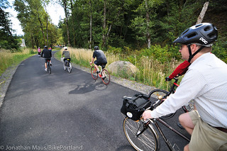
A gorgeous new segment of the Historic Columbia River Highway State Trail is now officially open to the public. The new paved path is 12 feet wide and 1.6 miles long. It goes from the John B Yeon State Park trailhead to the Moffett Creek Bridge. Its completion marks a significant milestone because it’s now possible to ride a bicycle between Troutdale and Cascade Locks without ever having to ride on the shoulder of Interstate 84.
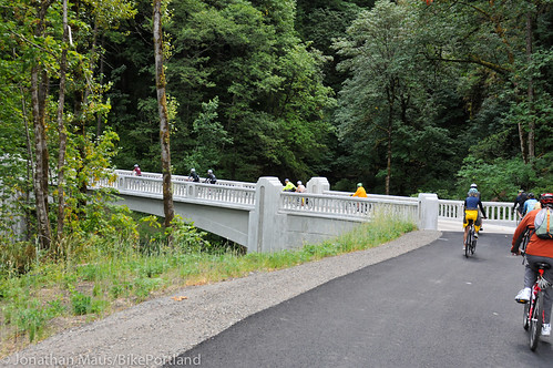
We got a sneak peek at this back in August and it is a truly stunning place to ride. The new shared-use path is 12-feet wide and is ADA compatible. There’s also a new 76-foot long, 16-foot wide bridge over McCord Creek that ODOT says, “reflects the craftsmanship of the original highway design.” Other features include a new picnic and rest area with views of Beacon Rock and a link to US Forest Service Trail 400 that connects to Elowah Falls.
This $8.1 million project (funded in part by an FHWA grant) was the final link in what is now a continuous, 34-mile ride between Troutdale and Cascade Locks with 26 miles on the Historic Columbia River Highway (a beautiful, narrow road open for driving and bicycling) and 6.5 miles of shared-use path. ODOT’s ultimate plans are to extend this route all the way to Hood River by 2016 — which will be the 100th birthday of the Historic Highway. That final 9 miles is estimated to cost about $47 million. To date, ODOT has restored 62 of the original 73 miles of the Historic Highway between Troutdale and The Dalles.
As we’ve reported, this new path has already sparked economic development in Cascade Locks and as word spreads this is sure to become a signature bicycling attraction in the region. Troutdale is only about 16 miles east of downtown Portland so get out there this weekend and check it out!
Here are a few more photos to whet your appetite…


Thanks for reading.
BikePortland has served this community with independent community journalism since 2005. We rely on subscriptions from readers like you to survive. Your financial support is vital in keeping this valuable resource alive and well.
Please subscribe today to strengthen and expand our work.
Sweet!! I highly recommend riding along this new facility from what I saw when I road it a few months ago (during a special tour). Now we just need some more bike friendly hostels out there… 🙂
This is so awesome. Thanks for bringing this to my attention.
Anyone got thoughts on getting to Troutdale? Have some reservations about some routes, specifically Marine Drive west of 33rd, but might try it regardless if it connects to Troutdale. Or is it easier to just take the NE.Tillamook/Halsey/Grant/yadda yadda through the city?
Either way, excited to try this out.
Marine Drive is good. There’s a bike trail most of the way, though if you’re a fast rider you might prefer to stick to the shoulder to avoid the tree roots. One of my usual rides takes Marine Drive to Troutdale, then back to Portland on Halsey.
Marine drive is actually not as bad as it would seem. I work off of Marine drive out past 205, and have ridden on it countless times.
Outside of commute hours, there isn’t much traffic, and the shoulder is decently wide, and you don’t have nearly as much cross traffic as you would on surface streets… maybe one intersection the equivalent of every 30-40 blocks or so.
And there is a path that parallels it for about half of the distance.
Oh, cool. I haven’t done Marine Drive for a while cuz I wasn’t comfortable at the time. I’ll have to go check it out again. Thanks!
Oh for sure, I totally get that – the first time I rode on it I felt very exposed. Your name says Linnton, so I must imagine you ride on HWY 30 sometimes? I’d put Marine drive above HWY 30 as far as comfort level is concerned, at least for me.
If you’re south side, Springwater out to Gresham-Fairview trail isn’t too bad. Puts you up by Blue Lake, from there I’m not sure, I’ve always gone West from there on the Marine Drive path, which is pretty nice, funny that out there with no houses around there always seems to be more joggers than cyclists on it.
Humm making me think I might need a nice long day ride in the near future.
You can turn right on Halsey (where the G-F trail terminates at the north end) and take Halsey all the way out to Troutdale and then onto the historic highway. Halsey has a bike path the whole way, but you need to watch for glass.
Can’t wait to ride it. I’ve ridden IN the Gorge many times, but never been able to bring myself to ride TO the Gorge until now.
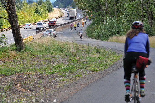
Last photo, LMFTFY: “‘Separated’ from the interstate” 😉
I imagine that they plan on putting in a jersey wall or other fixed barrier. I’d still be every so slightly nervous about any people falling asleep at the wheel barreling onto the path right there without it.
It’s hard to tell from the angle, but it looks like the path is at the level of the top of the jersey sidewide.
It’s a weird angle. The path is actually raised about 4-5′ above the shoulder of the interstate in that section. Since Jonathon’s photo was taken a railing has been added to provide additional separation.
One thing this blog is missing is embedded maps. Or maybe I don’t know Portland as well as I thought…
My 2004 solo tour attempt was aborted at Elowah Falls because the shoulder of I-84 was so narrow that my loaded touring bike was getting buzzed dangerously close by logging trucks. I tried five times to ride the shoulder, lost my nerve, turned around and finally spent a second night at Ainsworth before going home the next day. I am glad to see this is now a doable ride and I plan to carve out a few days in the summer to give it another go.
I rode the route from Cascade Locks to McCord Creek and back a week ago: Spectacular! And the Scotch Porter at Thunder Island Brewery in Cascade Locks: Excellent!
Finally, great connectivity to the PCT!
In ’99 I walked into PDX from the PCT and didn’t much enjoy that I-84 shoulder!
This is a great route, I rode it before it was fully connected and still enjoyed it minus the gaps. Once it’s connected to Hood River then you’ll be able to head all the way out to the Twin Tunnels and Rowena Point and then down to Mosier.
I do hope though that they refer to it as a ‘Path’ as opposed to ‘Trail’ as it impedes the efforts of the Mountain Biking community to get actual Trail access due to semantic confusion.
And then on to The Dalles and beyond…. climbing State Road in Mosier and heading over to descending Sevenmile Hill Road into Chenoweth Canyon on a clear, wind-less day is highly recommended!
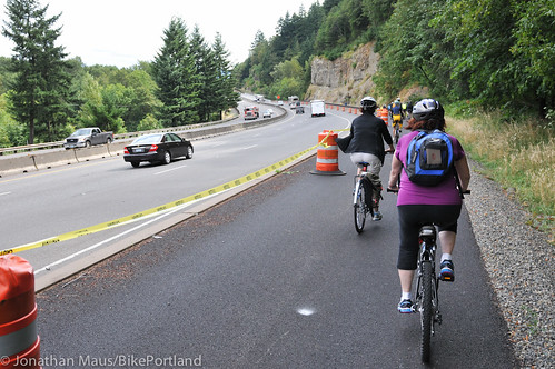
Looks like my ride on that path today was one of the first after the official opening, by total coincidence. The spot in the last photo now has a very nice railing between traffic and the bikes. There were, for some reason, quite a few ODOT and contractor folks out there today inspecting and working on various things, with vehicles and a WIDE truck nearly blocking the path. It was open, however, and I squeezed by with no one complaining.
The critical problem at this point is that ill-conceived stairway right above Cascade Locks. Folks touring, or even just riding unloaded on cargo bikes, long recumbents, trikes, velomobiles, tag-along bikes and with bike trailers are likely to turn back at the top as I did. Wheelchair users and others with mobility problems will also suffer the same fate. Cascade Locks is going to loose a lot of business until the project to bypass those stairs finally gets funded and built.
Monorail! Monorail!
The Friends of the Historic Columbia River Highway are raising money to replace the awkward stairs with a ramp. Go donate! http://www.hcrh.org/get-involved/
This is the secret information which is so hard to find with your search engine:
To find the mysteryous modern Babylon that is Cascade Locks; find NE Halsey Street at dawn and ride towards the sun. If you never ride on Interstate 84, that’s fine. A road’s danger to you is not measured by your personal fear of it’s conditions.
“A road’s danger to you is not measured by your personal fear of it’s [sic] conditions.”
Well, obviously not yours.
Fear frequently has little or no connection to actual risk.
Having already had one close call with being sideswiped by a semi that came well over the fog line, AND being middle-aged enough to have seen the effects of cumulative risk add up, I think my fear of riding on the narrowed shoulder of a freeway bridge is well-founded.
Let me add this, too: if you felt comfortable riding on this route before the new bridge, FINE. Say so and leave it at that.
There’s no need to belittle others as somehow illogical for having concerns about riding on a freeway bridge with a narrow shoulder.
Excited to ride this! Particularly as there is an ice-cream & burger joint in Cascade Locks that will make it doubly worth the ride!!
West of Yeon you have a choice of Interstate or the old hwy (open to cars!)? Not sure which is worse.
I’ve not really had any issues with cars on the section open to motorized vehicles, other than in the Corbett/Springdale vicinity.
What would be a good starting point to ride with my 4 year old on the trail-a-bike as an out and back? I would like to ride as much as possible without being with cars on the Historic Highway.
TIA.
The traffic really drops off at Ainsworth State Park, where most folks get on the freeway. It’s less than a mile and a half from there to the spot the bike path takes off. If you want to be certain to avoid cars altogether you can drive a little farther to John B Yeon State Park, but that’s past the bridge in the photo above that goes over McCord Creek, so you’d backtrack away from Cascade Locks to see it. Not very far though, maybe 2 miles. Sweet ride!
Thank you.
Actually, that’s incorrect. The McCord Creek bridge is just east of Yeon Park and west of Cascade Locks.
Great news!! This is the perfect antidote to reading about the Hawthorne Bridge rumble strip debacle!
Would like to do this ride. Where do I find directions to the trail heads?
Google directions to Elowah Falls Parking.
Here is a map of the link from Elowah Falls Parking lot to Cascade Locks. The first part isn’t a true breadcrumb trail, it just represents the link to the pre-existing path.
oops, here is the link
http://ridewithgps.com/routes/3540846
Heading east on I-84, take exit 35 (Ainsworth Park). Turn turn left at the stop sign, then an immediate right onto a frontage road which parallels I-84 eastbound. The frontage road ends at the parking lot for the trail head. It’s about 2.2 miles once you leave the freeway. Don’t miss the parking lot or you’ll be merging back onto I-84 eastbound.
And another reason to take the ride is Thunder Island Brewing in Cascade Locks is now open. (Th-Sun). They have a great location right on the water. And good beer!
Camping?
Looks like there is some at the marine park, but its a bit expensive and barren (more like an RV site it seems?). USFS says the Eagle Creek and Herman Creek CGs are closed. Is that “expect no services” or “no trespassing” type closed?
Good question … I’m not sure any of the campgrounds between Troutdale and Herman Creek are open year-round. The KOA and all of the Oregon State Park campgrounds all appear to be seasonal. Somehow I had thought something was open in the winter but I’m not finding it. Not sure about the legality of camping in a closed USFS campground.
I haven’t tried this, but I wouldn’t be surprised if you could find a place to camp somewhere off Herman Creek road. There’s a side road that goes up the mountain and might offer some dispersed (i.e., self-sufficient) options. Just watch REALLY carefully for poison oak! If you can handle a mile or two of singletrack, you could also head up the part of Gorge Trail 400 that’s open to bikes. I’ve seen a couple of fire roads up there that look just fine for camping.
No services. Gates are likely secured but I walk around them.
You Portlanders have it lucky now. Those of us in Hood River have a beach of a time riding on I-84 into westerlies to get to CLAC and Thunder Island… 😉
Does anyone know if the pavement that was so rough just west of the Eagle Creek stairs got redone this summer? That stretch was very rough in late May.
Not that persuasive I know, but I remember thinking “wasn’t this a PITA to ride before?”. I remember not having to dodge uprooted asphalt.
I wish someone would get Google to document this ride on there bike layer. I just looked and there are no bike layer routes between Troutdale and the cascades.