
The dream of connecting the 73-mile Historic Columbia River Highway between Troutdale and The Dalles will become even closer to reality after this weekend. A celebration with activities for the kids and an open house for new, ADA-accessible and bike-friendly campsites will be held at Viento State Park on Saturday to welcome two new miles of paved, carfree path.
When it first opened in 1922, the Historic Highway was a marvel of engineering. Referred to as a “poem in stone” and the first official “Scenic Highway” in America, it allowed adventure-seekers to explore deep into the Gorge from the comfort of their automobiles. But the old highway was considered old news when Interstate 84 came on the scene in 1975. A bit of over 10 years later, as mother nature reclaimed the road and many sections fell into disrepair, the Oregon Department of Transportation became obsessed with rebuilding the old highway as an alternate to the fast, loud interstate.
In 1986, 22 miles of the old highway were out of commission and needed to be rebuilt and/or reconnected. After this Saturday, when ODOT opens another two-mile section between Viento and Mitchell Point, we’ll have 18 miles of carfree paths between Troutdale and The Dalles and just 3.8 miles of the 73 original miles will remain (of which ODOT has funding for all but 1.6 miles).
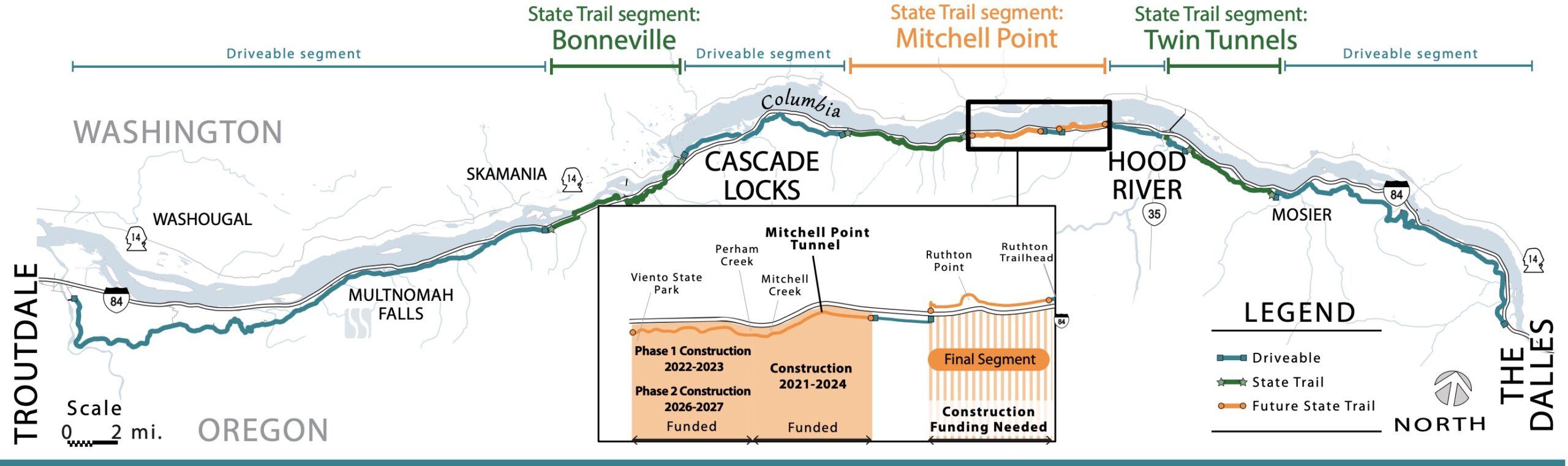
The new segment will give riders, walkers, and rollers of all types (except car drivers) eight miles to enjoy between Wyeth Trailhead (exit 51 off I-84) and Mitchell Point (even more if you ride on shared backroads from Cascade Locks). The 0.7 segment to reach Mitchell Point Tunnel — and the tunnel itself — aren’t quite ready yet. The spectacular, 655-foot tunnel and adjacent 1.5 mile segment of the carfree trail will open next spring (2024) and will be fully connected to Viento in 2026 (both projects are already funded and under construction).
After that, the final 1.6 mile segment from Ruthton Point to Hood river will be all that’s left. ODOT says they need about $45 million to build it and they plan to reach a 50% design milestone this fall.
According to Gorge Pedal organizer, former Historic Columbia River Highway Advisory Committee member, and veteran cycling advocate Armando Zelada, the new trail segment that opens Saturday is something we should all be excited about:

“This trail portion is an intimate view of the Gorge, waterfalls, and has grand views up and down the Columbia River. It deserves visiting for that intimacy, much like a quartet playing is different than the full orchestral blast of Multnomah Falls. It allows one to actually follow the original Highway without vehicles as the route serpentines within the forest canopy and pops out to see the carved Columbia River Gorge slopes. And it wouldn’t hurt for you to daydream that the 100-plus year old road might just have been built on top of footpaths worn down by indigenous people who have occupied this Gorge for 9 to 12,000 years or more.”
For more on the route between Cascade Locks and Viento, check my recent report and photos.
And if you’re looking for a fun event in the Gorge this weekend, the ribbon-cutting celebration will be Saturday (9/9) from 10:00 am to 1:00 pm at Viento State Park South Campground. ODOT will have food from Empanadas Maria Elba on-site and there will be a kids scavenger hunt and other activities. Car parking is very limited, so consider taking Columbia Area Transit (CAT) from Portland. You can also bike there from another trailhead nearby or join Portland Bicycling Club for a group ride to the celebration that leaves from Cascade locks at 8:00 am.


Thanks for reading.
BikePortland has served this community with independent community journalism since 2005. We rely on subscriptions from readers like you to survive. Your financial support is vital in keeping this valuable resource alive and well.
Please subscribe today to strengthen and expand our work.
The Gorge Express bus rocks. I love riding one-way out from Portland early in the morning and then riding the bus back from Cascade Locks. Looking forward to the new trail section!
https://www.ridecatbus.org/columbia-gorge-express-schedule-starting-september-9th/
Funny how ODOT’s diagram refers to the road sections as “driveable,” which just shows their automotive mentality, IMO.
A diagram with the word “driveable” isn’t speaking to me as a cyclist, but this language does seem to speak to people who drive cars and trucks.
Before you reply (looking at you, Watts) saying “They are just saying which sections to expect cars on,” think about how the diagram would be different if the entire thing said “bikeable.”
Wouldn’t a “bikeable” label be kind of useless though? besides freeways isn’t everything bikeable? so they’d just put that on the whole thing?
Just about all the freeways in Oregon are “bikeable” except for OR 217, I-5 between 205 and Washington state line (I wouldn’t ride I-5 through Salem or Eugene, either, though),I-205 North of Oregon City, and I-84 west of Troutdale. I have ridden I-84 between Troutdale and the Dalles a lot. (Eastbound, I take the trail to avoid the tunnel at Bonneville.)
I am interested in riding from Portland to Parkdale, but I am having a hard time finding a map for this sections. ODOT has a an overview, but no detail. Does anyone know of a route on Ridewithgps or strava from Crown Point to Hood River? Or even from Cascade Locks to Hood River? I am not clear where the road and highway sections are and what that access/condition looks like.
Hood River from this side is a tough ask, from this side of Mitchell Point to Hood River is mostly on I84, not for the faint of heart.
Jonathan just explained above how this will get done in the next couple of years but we are not there yet.
If you click over to Ride with GPS and start searching for “Portland to Parkdale” maps, you’ll find plenty. Nicks B’day ride is about 95 miles or so, but I’ve seen some that are about 80 miles. You’re looking at over 5000 feet of climbing, but it’s a real adventure. Here’s an idea: Find bike rides from Portland to Lost Lake then Lost Lake to Parkdale. Have fun. It’s good riding up there.
great tips, thanks! I found a promising route that shows how to get through Cascade Locks and where the I-84 section is. I also like the route that parallels 26 on E. Barlow Trail road- I haven’t ridden that, but I have been on Lost Lake- this seems like a no-brainer! Thank you
This is great news!
Good on ya ODOT!!! Thank you…..keep it up.
Nice Job ODOT!! Glad to see the support for cyclists, hikers and non-motorized rollers. Keep it up!
This entire trail is a great project for the state. Wonderful job!
But I’m sure I-84 (first named I-80N) was built back in the 50s, I not 1975. As a child in the late 50s my parents were driving on it then on our way Hood River.
Thanks MarkJ. Completed and officially open to public in its entirety as I-84 in 1975. No doubt the way was passable on a combo of the interstate (which yes, began in the 1950s) and the historic highway.
That 1975 date you mention is when I-80N (now I-84) was complete in the entire state, not in the Gorge, when the last section of the interstate was built near Baker City.
The water-level route that is now 84 was built in drips and drops over the years, starting in the 1930’s when the old highway was too narrow and windy for trucks and too slow for folks who wanted to get somewhere fast. The water-level route was complete by 1954, and that’s when there was a true bypass to the old highway. Over the next decade and a half this water level route would be upgraded to interstate standards.
Great to see this coverage! I drove past there on Sunday and saw a lot of people on the trail already, up to the point where it’s CLOSED west of Mitchell Point. The new restrooms and facilities at Viento sound great as well. Can’t wait to get out there sometime and do a nice big ride and campout.