tied together with the newly proposed
Mt. Scott/Scouter Mt. Trail Loop.
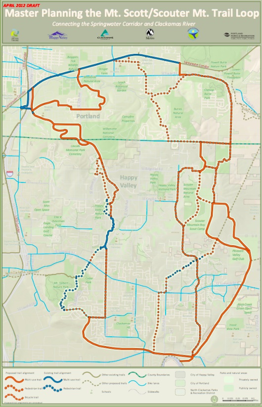
Metro is prepping for the public unveiling of an exciting new network of paths that span from just south of the Powell Butte Nature Park all the way down to the Clackamas River. The Mt. Scott/Scouter Mt. Trail Loop is one of twenty “Connecting Green trail packages“ proposed by Metro’s Blue Ribbon Committee for Trails.
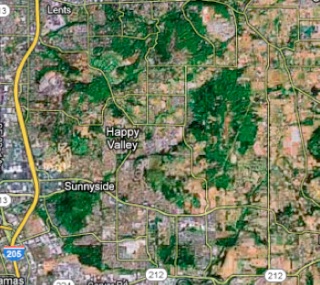
According to a document and maps released by Metro today, the plans call for a combination of paved multi-use paths as well as hiking and biking trails. In all, the network would encompass about 17 miles of paths winding around the city of Happy Valley and between a corridor bordered by the Springwater path, the I-205 multi-use path , SE 172nd Avenue and SE Sunnyside Road.
According to Metro, “the trail would serve transportation, commuter and recreational needs. The trail could also serve as a part of the area’s “Safe Routes to Schools” programs.”
Here’s a look at the proposed network (PDF here):
At this point, Metro and their regional partners are only in the planning stages. No funding has yet been identified to actually build the paths and trails or to purchase the easements and right-of-way necessary to make it happen. The draft master plan is slated to be finished by March of next year.
The first public open house to view the draft plans is set for June 7th from 5:30 to 8:00 pm at the Happy Valley City Hall (160000 SE Misty Drive). Stay tuned for more developments.


Thanks for reading.
BikePortland has served this community with independent community journalism since 2005. We rely on subscriptions from readers like you to survive. Your financial support is vital in keeping this valuable resource alive and well.
Please subscribe today to strengthen and expand our work.
Of course this is wonderful. But I hope they come up with a different name for the Mt. Scott/Scouter Mt. trail. I’m not dyslexic now but may end up that way if they don’t!
Dog is my copilot?
I’m all for this. But. . . I’d rather these agencies work with OR State Parks to prioritize the completion of the Cazadero Trail. It ***almost*** reaches the Clackamas River already. Unfortunately, the route dead ends at Camp Kuratli, a Salvation Army Camp which has thrown up fences and electronic barriers to keep people from riding through. As it stands, riding down that section of the Cazadero Trail is a one-way proposition. To riders’ great frustration, the dead end is onlya few hundred yards from linking up with Highway 224, which provides a river level, wide shouldered cruise down to the great riding around Estacada.
As things now stand, riding from Gresham to Estacada requires spending some time riding on narrow, curvy, and very steep farm roads that are nowadays full of fast, crowded suburban traffic. Amisigger Road is dangerous, Tickle Creek Road is quiet, but very climbing oriented (and requires a steep climb, on an un-shouldered section of crowded Highway 211- scary!), and 232nd requires climbing another un-shouldered steep road never intended for the suburban traffic volumes it now features (climbing at my limit is cool; climbing at my limit while being buzzed by exurban commuters and industrial farm trucks regularly is not cool).
The Cazadero Trail, when completed, would allow a gentle climb/descent on a good gravel surface that opens up miles of fun touring. The fact that it only requires several hundred yards of right of way (or rebuilding a trestle) should make it a regional priority.
“climbing at my limit is cool; climbing at my limit while being buzzed by exurban commuters and industrial farm trucks regularly is not cool”
well said.
I didn’t know the new trail stopped shy of 224. This is disturbing for a number of reasons. And, yeah, Tickle Creek is great, but the climb out on 211 with no shoulder & fast traffic is fairly horrifying.
The Cazadero Trail *is* a regional priority, and barring any major issues should be completed in the next few years. Metro has already acquired the right-of-way except for the camp section. There won’t be a new trestle – the costs involved are too high and the current plans are a set of switchbacks similar to what exists at Tophill on the Banks-Vernonia Trail. Groundbreaking on the trail could begin in as little as 2 years provided the stars all align. These projects are all long-term stuff, whereas the Cazadero Trail was planned close to a decade ago and is only now approaching the stage where actual construction happens. It’s perfectly appropriate for these agencies to be identifying and planning future trails. Any new trail will require 5-15 years of work to bring to fruition, and it’s entirely normal for multiple projects to be in the pipeline at any given moment.
Matt, since you seem to be really well informed about the Cazadero trail connexion between Boring and 212 (& the online info that I’m able to find is scant to non-existant) – when i looked last fall at the Boring trailhead it was a gravel surface, of a size that made it useable by pretty much mt. bikes only. Do you know if this this the ultimate surfacing? Or will it be paved at some time in the future?
The lack of online information about the current status of the trail projects around the region is very frustrating. Neither Metro nor the other agencies involved are good at communicating this information, especially between the time that funding is committed and construction is finished.
You can see here that Metro has had a “plan” of some sorts (click on the PDF link at the bottom the web page) since 2007. So. . . why are they spending time coming up with multi-million dollar plans for other projects while this project is worthy and waiting? I really admire the work that Metro and our other local agencies have done, but sometimes I think they are more in the habit of making proposals than finishing projects. All these ideas are great, so why do so many of them languish for years? Would it be better to focus the energy of our governments on one thing at a time and complete some projects quickly, rather than spending effort on coming up with new projects? Anyway, here’s the link: http://www.oregonmetro.gov/index.cfm/go/by.web/id=24606
I share your frustration with the overabundance of planning (less expensive) and the lack of implementation (much more expensive). As an urban Portlander I don’t often say this, but I’m somewhat envious of the Tualatin Hills Park & Rec (suburban west metro) bond measure passed several year ago – $100 mil total, with about $15 mil devoted to trails.
Wonder what it would take to put up & pass a similar measure for central/east Portland?
Oh. . . and I wonder what the “pedestrian trails” on the above map would be like. There should be an opportunity for some mountain bike access. Considering how little access there is in the city, if we’re going to pay for a bunch of new trails in areas that are clearly not wilderness-oriented, why not open them up to bikes? That would be killing two birds with one stone.
“why not open them up to bikes?” Well, one reason would be because joggers and hikers are intimidated by mountain bike users on trails. There absolutely should be more single track in Portland, but the need for single track needs to be appropriately balanced with the needs of other trail users. There will be some trails which will be (and *should* be) off-limits to bicycle and/or equestrian use.
Sure. It’s just a matter of which trails. And right now, with the exception of a few miles of trail at Powell Butte and that half mile trail in Forest Park, ALL the trails in town are pedestrian only. If we are going to have access to ANY singletrack trails, it’s likely that they will be new trails (given the failure of the FP Singletrack committee to open any of the existing trails in FP). The new singletrack trails in the Happy Valley area could be such an opportunity.
That could be neat. Hopefully they’re finding old rail alignments where possible; I do see a couple powerline alignments. The railroad alignments tend to actually be bike and hikeable as a transportation corridor, the powerline alignments tend to have no regard for terrain, making for some unbelievably steep climbs that tend to discourage travel. Compare the Springwater Corridor (even the steepest spots up towards Boring) to, say, the Westside Regional Trail near Tigard (which gets close to having walls that are more level), or the Waterhouse Powerlines Trail towards Morgan’s Run. If you don’t have a itty bitty chainring and a huge granny gear, and your name isn’t Thor, you’re not going to pedal up those grades.
Thanks for covering this Jonathan. I did notice though that the link to the PDF above goes to a different map then the one shown. Is this a mistake?
The rate of work on the region’s trail system has definitely picked up speed from where it was a decade ago. Lots of exciting trail projects are afoot in this region thanks in to hard working citizen advocates and local government staff. We are lucky to have so many dedicated folks working on the regional trails plan.
There are lots of ways for folks who want to see more things happen faster to get involved and help.
Speaking of the Cazadero Trail, is construction of Boring Station Trailhead complete? I was scheduled for completion last fall but I have not heard anything?
Also, what’s the latest on the Trolley Trail? It was last scheduled to open in March but I have seen any updates.
Jim
“There are lots of ways for folks who want to see more things happen faster to get involved and help. “…. for example: “The 2nd Annual Regional Trails Fair: Exploring the Intertwine” is next Wednesday April 25, 2012 at Metro (600 NE Grand). For more information contact Mel Hui at Metro 503-797-1731.
http://theintertwine.org/news/2nd-annual-regional-trails-fair-%E2%80%93-april-25-0
Does anyone know whats going on along the abandoned Cazadero rail line between Barton and the Eagle Creek Bridge? It seems that there are road graders and a lot of gravel has been put down for a good road surface. Also, between each road crossing the Cazadero line, there are bollard posts that have been placed to prevent cars from driving along the right of way.
The begining of the gravel packed trail starts is about a block south of 224 on S.E. Bakers Ferry Road. So far, the gravel road has been put in all the way to the Eagle Creek/Sandy Highway 211. From that intersection all the way to Eagle Creek, the Cazadero right of way has been cleared but no gravel placed.
No one around the area seems to know who is doing the clearing and placement of gravel on the right of way. I’ve researched online and have found nothing there.
Just a complete shot in the dark, but it sounds like you and the neighbors didn’t read the article or see the public records mentioned in the article. Kind of like Arthur Dent from Hitchhiker’s Guide to the Galaxy, but the similarity stops in that the plans in this case were obvious and well publicized…
I don’t see any articles on this webpage or the metro webpage on when the construction of the Cazadero Trail woud begin or the route; it only discusses the route from Barton to Boring through the Deep Creek area and the Salvation Army Camp. This grading project is from Barton towards Estacada. I live in Sherwood so am rarely out in that area.
A couple neigbors that I asked said they thought the electric company was putting in the gravel road so they could maintain the power lines.
I just emailed Metro asking them for the particulars on the project.
I went to Metallion Industries about a mile from Estacada on Friday (and the Cazadero Trail runs right in front of their place) and the guy whoe’s family owns the place didn’t know anything about it or what was going on. He said he noticed the grading/graveling going on a few miles down the road near the Eagle Creek Bridge. So if the locals don’t know whats going on, that tells me someone at Metro didn’t do a good job of publicizing it.
A FYI
I got some information from Rocky Houston from the State of Oregon. Turns out this Cazadero State Trail is NOT a Metro project. The Oregon State Parks Department has jurisdiction from Boring to Estacada.
Rocky tells me the trail they are putting in now is 3.83 miles from Barton to Eagle Creek, the Boring to Barton segment is 4.0 miles. The last segment of the project is 3.5 miles from Eagle Creek to Estacada for a total of 11.33 miles from Boring to Estacada.
If anyone wants the one page cheat sheet on the project, send me your email address and I’ll send it to you.
Finally got the answer I was looking for.