The good news is the City of Portland is set to break ground on a $25 million project to replace the NE 42nd Avenue Bridge over Lombard Street. The bad news is the work will require a full, two-year closure of a key link in the bike network.
The Portland Bureau of Transportation (PBOT) announced the project and potential detour impacts on Tuesday.
Starting Monday, August 4th, the agency says they will post signs for a freight truck detour that will take northbound drivers east on NE Killingsworth to NE 82nd. Southbound freight traffic will be directed to go east on NE Columbia to NE Cully, then south to Killingsworth.
This freight detour is notable because it will mean increased volume of large trucks on Killingsworth, a major bikeway that recently received protected bike lanes.

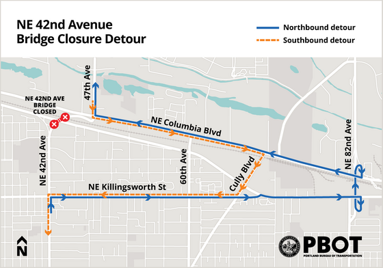
PBOT says the bridge carries about 5,000 car trips per day, so expect even more drivers on nearby roads during the closure.
For bicycle riders, there’s no nearby bike facility to use, so PBOT says they don’t plan on posting a specific bike detour. The existing 42nd Avenue Bridge isn’t great for bicycling, but at least it’s a viable way to connect from the NE Holman Neighborhood Greenway to the bike path on NE 47th that connects to Whitaker Ponds and the Portland Airport route. Once the bridge is closed, the best way to cross Columbia northbound is a half-mile west at NE 33rd.
To answer questions about this significant closure and detours, PBOT will host a webinar on July 31st from 6:00 to 7:30 pm. You can register for that meeting via Zoom here.
The $25 million project was initially slated to break ground in 2021 at a cost of $17 million. The funding comes from a mix of sources including System Development Charges, Heavy Vehicle Use Taxes, State of Oregon, Portland Clean Energy Fund, and others.
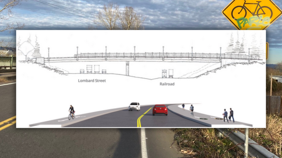
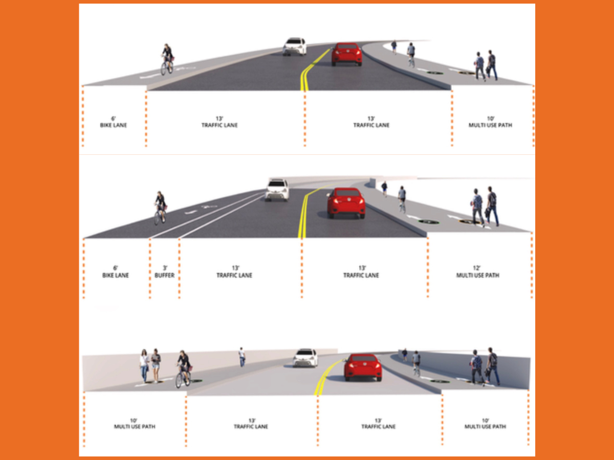
The new bridge will be an upgrade from the sharrowed, shared-lane facility that exists today. It will have a wide bike lane and painted buffer on the west side, two 13-foot wide general travel lanes, and a 12-foot wide biking and walking path on the east side.
As I shared last fall, this project will also trigger construction of a better bike lane on Lombard where it goes under the bridge. Currently, bridge support columns cause a gap in the bike lane at this location. In 2015, that gap might have contributed to the death of Martin Greenough was hit and killed by a drunk driver while cycling under the bridge. PBOT partnered with ODOT and will widen the road under the bridge to create room for a new bike lane.
Check the official project website for more information.
 over Lombard is 'ready to go'")


Thanks for reading.
BikePortland has served this community with independent community journalism since 2005. We rely on subscriptions from readers like you to survive. Your financial support is vital in keeping this valuable resource alive and well.
Please subscribe today to strengthen and expand our work.
I hope bikers using the 33rd overpass for the first time are prepared for its current tdangerous reality. And more semis will continue to get stuck on the northbound 33rd lflyover than.before 42nd was closed.
Are you talking about northbound or southbound? Southbound, the worst part of the interchange is having to share the slip lane on Columbia to get onto the overpass. Northbound doesn’t seem as bad to me, because it is downhill.
They both have danger points but northbound is worse due to merge at bottom of downhill and narrowness of flyover right before mergepoint with driver attention to their own dangerous blind merge onto westbound Columbia
Thanks for the reply! I agree that there are hazards going northbound.
That detour seems nonsensical to me. 33rd is twice as close as 82nd, and 33rd has the same level freight classification as 42nd (Truck Access Street). From the corner of 42nd and Killingsworth to 47th, the detour via 33rd is 2.4 miles long and spends a little over half a mile on non-freight streets, while the one via 82nd is 4.8 miles long and spends about 1.5 miles on non-freight streets. I can’t think of a single reason to prefer the Cully/82nd detour over the 33rd one – I’d be curious as to what went into that decision.
This is a freight detour. Perhaps the 33rd bridge is not suitable for semi trucks? It seems like trying to take the ramp onto eastbound Columbia Blvd, in particular, would be really sketchy if you were hauling a big long trailer. Also, 82nd has better access to the industrial area off of cornfoot road than 33rd does.
I suppose. I guess when I think of freight that would be most likely to use 42nd, it’s smaller box trucks making local deliveries rather than semis, but I guess that’s more of an assumption than anything else.
Depending on where you’re going if headed North or where you’re coming from if headed south, there are quite a few other options. Obviously it can be a choose your own adventure.
If I were to use 33rd, I’d just go all the way out to Marine drive if I wasn’t in a hurry. Much more pleasant to be along the water.
33rd has a restriction on trucks over 50ft long – I imagine that’s the primary driver behind this decision.
Ah, that makes sense. Thanks!
Why does a 35mph street need lane widths a whole foot wider than interstate highway lanes?
I’m not an engineer, but strong hunch is that this was a political decision due to the project being partially funded by the Heavy Vehicle Use Tax, which is paid by freight operators. Yes it needs to be wider for large trucks, but with that HVUT funding, PBOT would be even more likely to do whatever freight advocates told them to do.
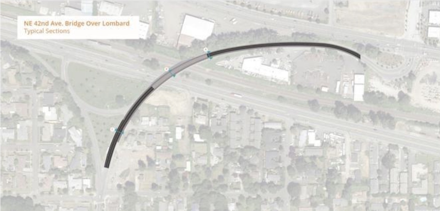
The radius of the curve might have something to do with making it more manageable and safer for freight.
The bridge looks great! I can’t wait to ride it. Two questions:
1) will the street between Columbia and the new bridge also be updated for this project? That’s the worst part of travelling across the bridge by bike, at least southbound.
2) is the separated path on Cornfoot still going to be constructed this summer? If so its utility will be really decreased by the closure of the 42nd street bridge. The (very nice) path along the section of 42nd between Cornfoot and Columbia has been in an orphan state for years. It will be ironic (and sad!) if the 42nd path is finally extended but essentially unreachable. Such haphazard and inexplicable sequencing of projects gives the impression of incompetence or indifference. It seems like something the communications foks at PBOT could manage….
Not close to great, but you can ride the south sidewalk/dirtpath along Columbia and take 60th. There is no shoulder along 60th between Columbia and Lombard, but at least it’s lower traffic (though it probably won’t be during the project). Maybe PBOT could spruce these up a bit to put it into the realm of adequacy.
Heck, why not close the right EB lane of Columbia between 47th and 60th? It merges into a single lane at 64th anyway. Make the closed lane pedestrian and bike accessible. “Better Columbia.” Closing it throughout the bridge construction would be great, but at least enact it no later than the completion of Cornfoot. EB Columbia west of 47th was 1 lane for months and months and the car traffic impact seemed to be minimal.
Great suggestion.
Thanks for the tip! I’ll give it a spin sometime.
Funny that PBOT won’t give any recommendations for a cycling detour – as though it would cost them something. I used that bridge all the time, despite its lack of “bicycle facilities.” It was a great way to get to Marine Drive, and I look forward to using the new bridge when it’s complete.
Funny thing, our neighborhood received a notice that there will be multiple nights of “overnight” construction on the Belmont Library, for a part of the project that requires closure of SE Cesar Chavez, presumably just for one block. The city has decided that motor vehicles cannot be inconvenienced by having this small stretch of one street closed during the day, even though there are many parallel streets they could take. So instead, neighbors will be kept awake by construction in the middle of the night. Yet two years of this kind of disruption for bicycles is unavoidable, apparently.
I’m curious: What practical detour route you would propose if the stretch in front of the library were closed to vehicle traffic during peak hours that would provide less disruption than night construction?
One correction – the bike lanes on NE Killingsworth have not been upgraded yet. The project website says paving will happen this summer but no signs of it even being started yet
We’re not even 1/3 the way through summer, so that seems reasonable.
PBOT repaved already, but they deferred the restriping that creates the protected bike lanes. PBOT originally planned to repave the entire width of Killingsworth, and they were going to restripe at the same time. But their pavement expert decided that only the car lanes needed repaving, and the rest of the asphalt was fine. I’m not very hopeful that the restriping will happen this year. I’m the neighborhood land use contact for Cully, so I’ve been in touch with the project manager over the years. The PM is not responsive right now, and usually that means no progress on construction. In contrast, the PM for the 42nd Ave bridge is pretty responsive right now.
Any idea which option PBOT will pick A, B or C and what the matrix are for that decision??
Hi Sam,
The A B and C are just three different views of the bridge cross-section. They are not three options under consideration. AFAIK.
Disappointed to see one direction in such a habitually high-speed zone relying on paint for separation – especially with the news of the death on Powell last night with only paint as a separator. Would love to see them as a concrete separator like they’re doing on NW Naito.
Heck yah! Glad to see it going to construction. Feels like I drew that elevation-view sketch about 10 years ago. (It’s been modified somewhat since then)