This summer, the Portland Bureau of Transportation will break ground on the most exciting bike infrastructure project we’ve seen in many years. On Wednesday PBOT released 100% design plans for the North Willamette Active Transportation Corridor Project that make it crystal clear just how transformative the changes will be for this vital connection to and from St. Johns.
The $6 million federally-funded project will come with a significant update to the bike lanes and road profile of a three mile stretch of N Willamette Blvd between N Rosa Parks Way and N Richmond. PBOT plans to add concrete curbs to protect the bike lane, establish prohibitions on driver turning movements and lane access at key intersections, extend median islands to reduce traffic exposure for bicycle riders and walkers, add speed bumps, and make a host of other safety and traffic calming-related changes.
100% design plans aren’t final or exactly what we’ll see on the ground, but they’re very close. Close enough for PBOT to put the project out for bid so they can break ground this summer. With the release of new documents on Wednesday, PBOT has given us even more detailed visualizations and plans than the 60% plans they shared in March of last year. Along with the plan drawings, they’ve shared narrative explanations of several key changes at specific intersections.
Below is what we’ve learned thanks to an annotated map of the full corridor design…
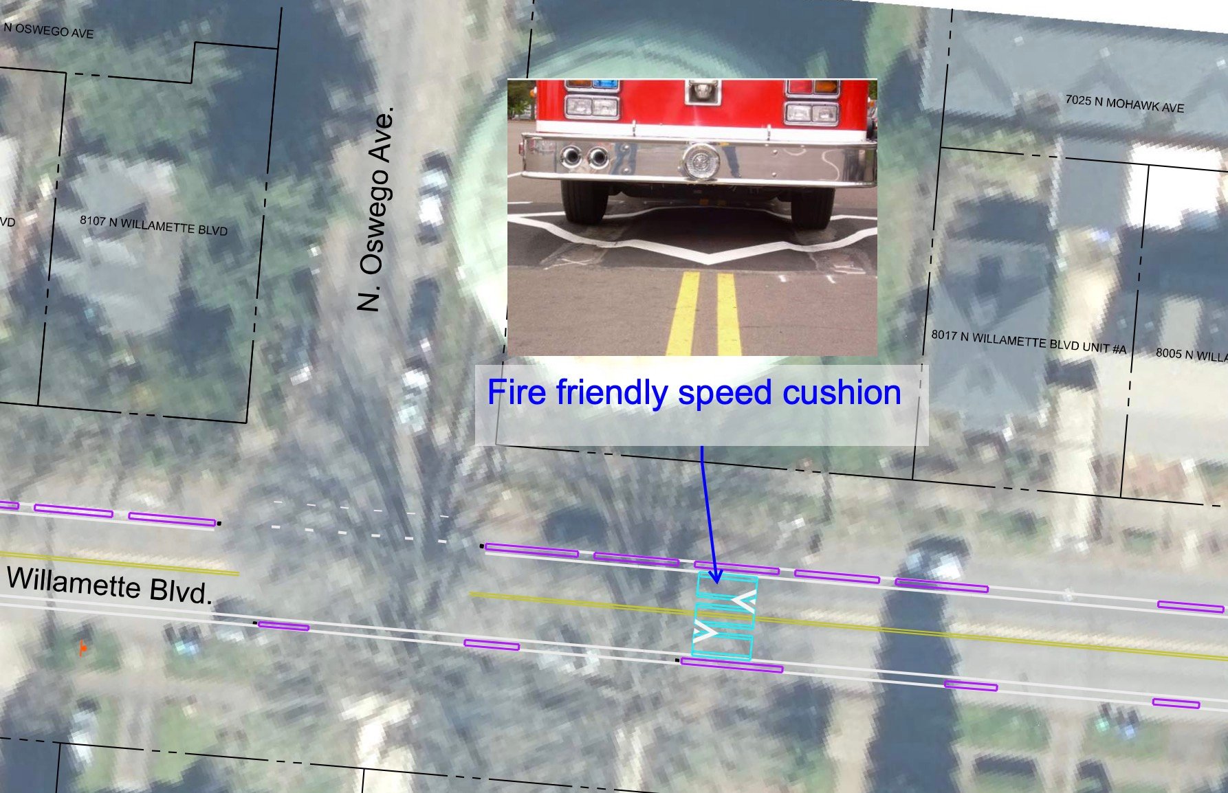
Driver speeds on Willamette are likely to come way down thanks to 41 new “fire-friendly speed cushions” being installed along the three-mile stretch.
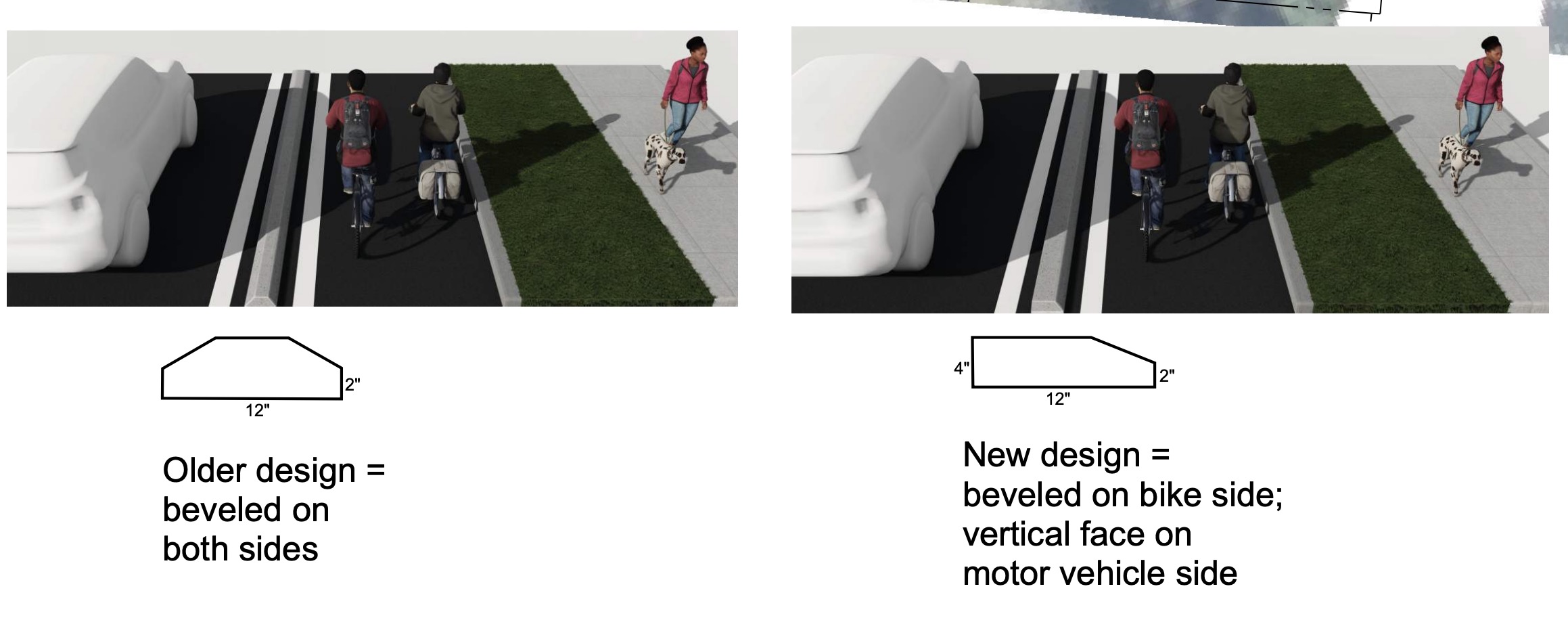
PBOT will debut a new design of their bike lane curbs. Instead of a symmetrical profile with bevels on both sides like the currently used curbs, the new design will have a squared-off profile on the drivers’ side. The total height looks a bit shorter (although I’m not sure about that), but the drivers’ side will now be a sharper 4-inches high instead of a 2-inch height with a bevel.
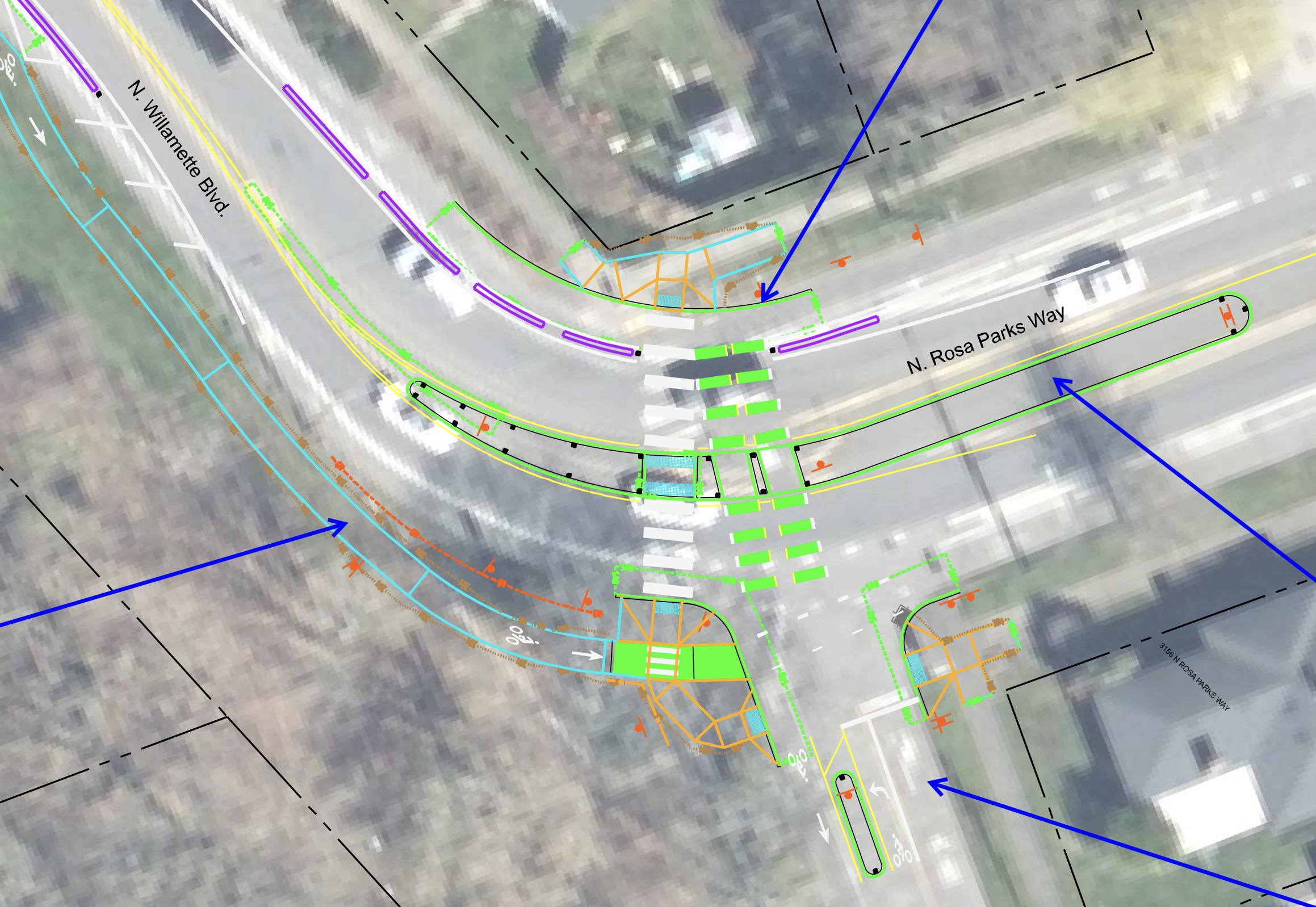
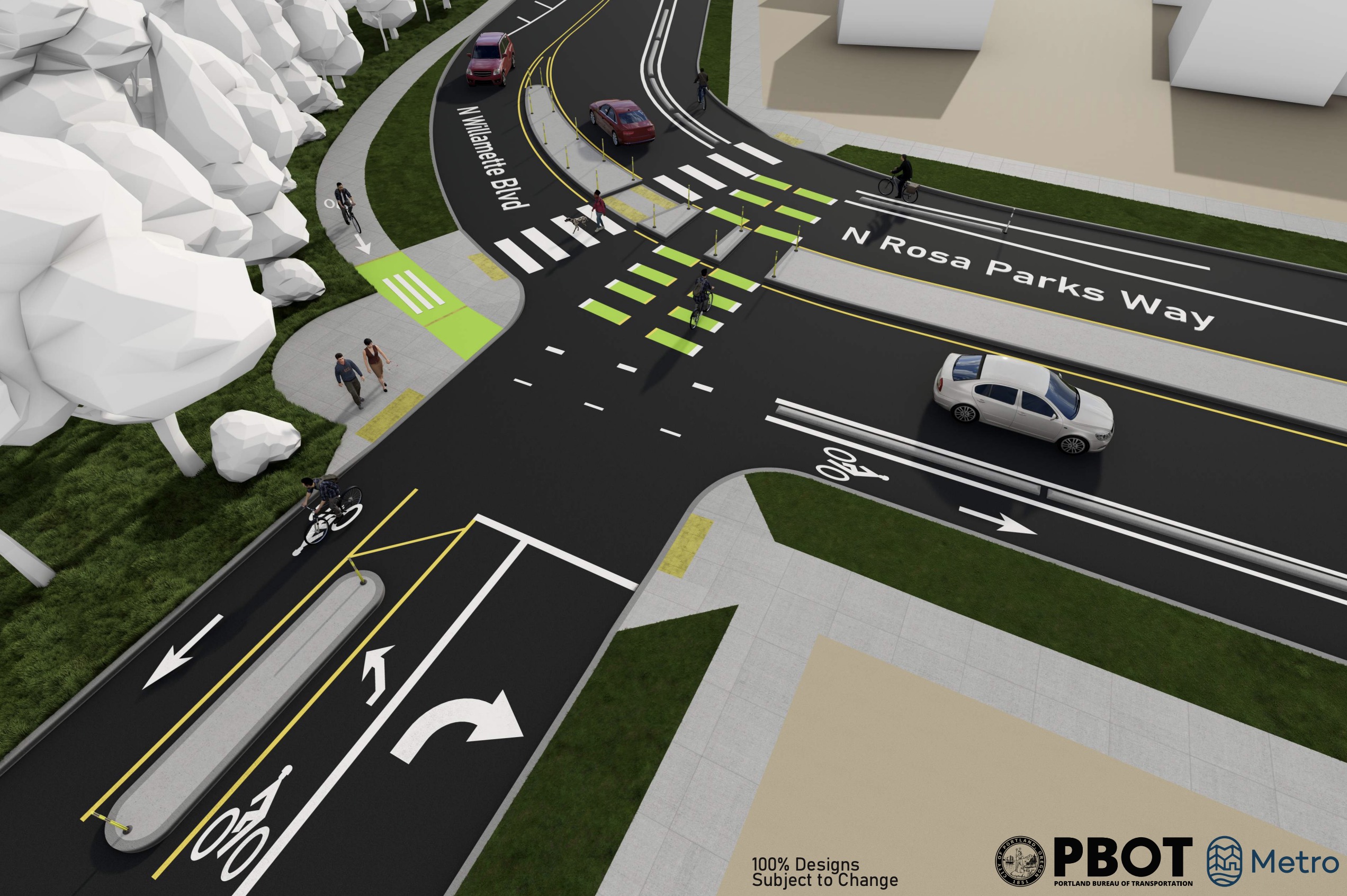
Starting from the southern end, PBOT plans to make big changes to the Rosa Parks Way intersection. They’ll widen the road, add concrete curbs to protect the bike lane for the entirety of the curve, separate the southbound bike lane completely from the road, and add more robust medians to calm car users and limit their turning movements.
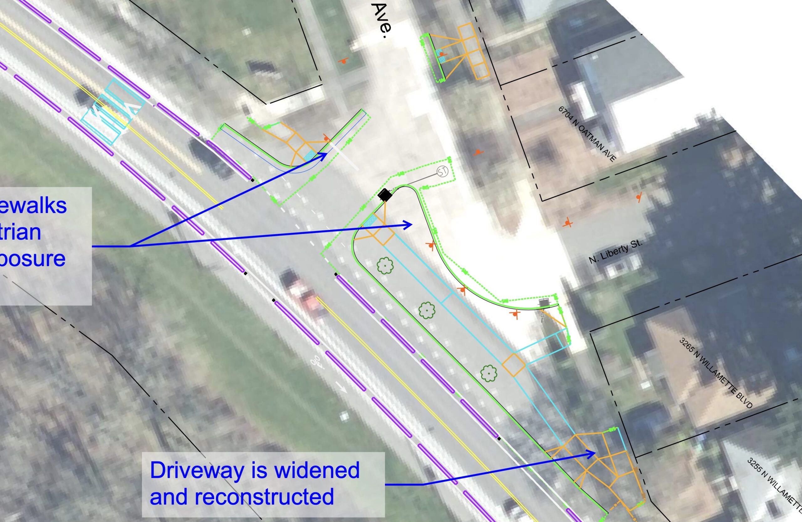
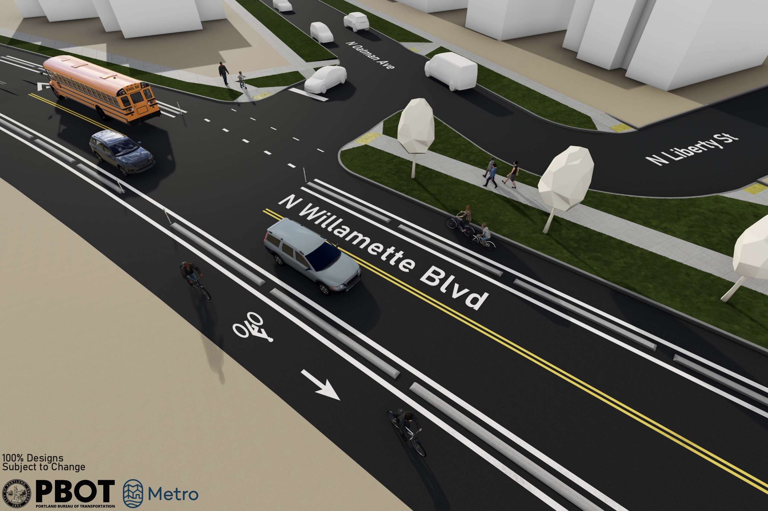
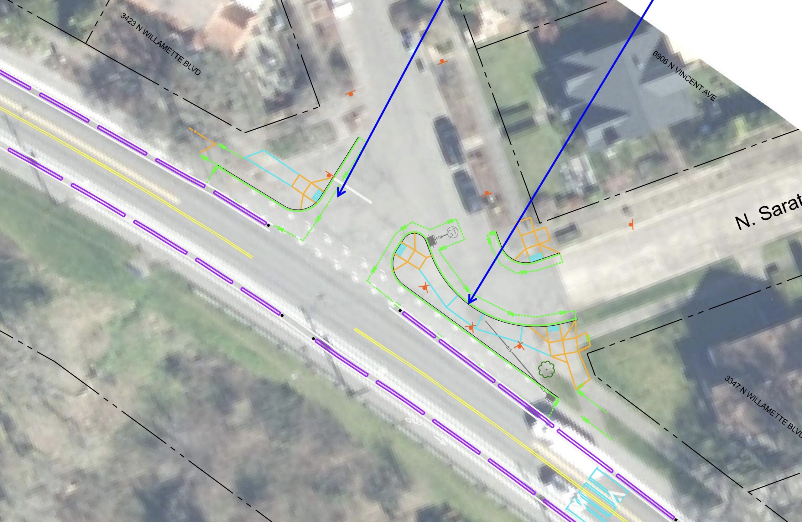
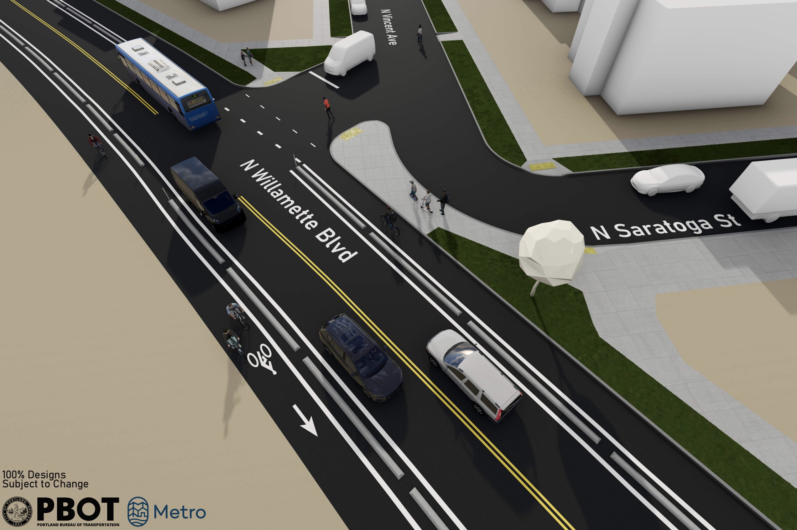
Where N Willamette intersects with N Oatman/Liberty and N Vincent/Saratoga, new large concrete medians will reduce the width of expansive intersections by about 80%.
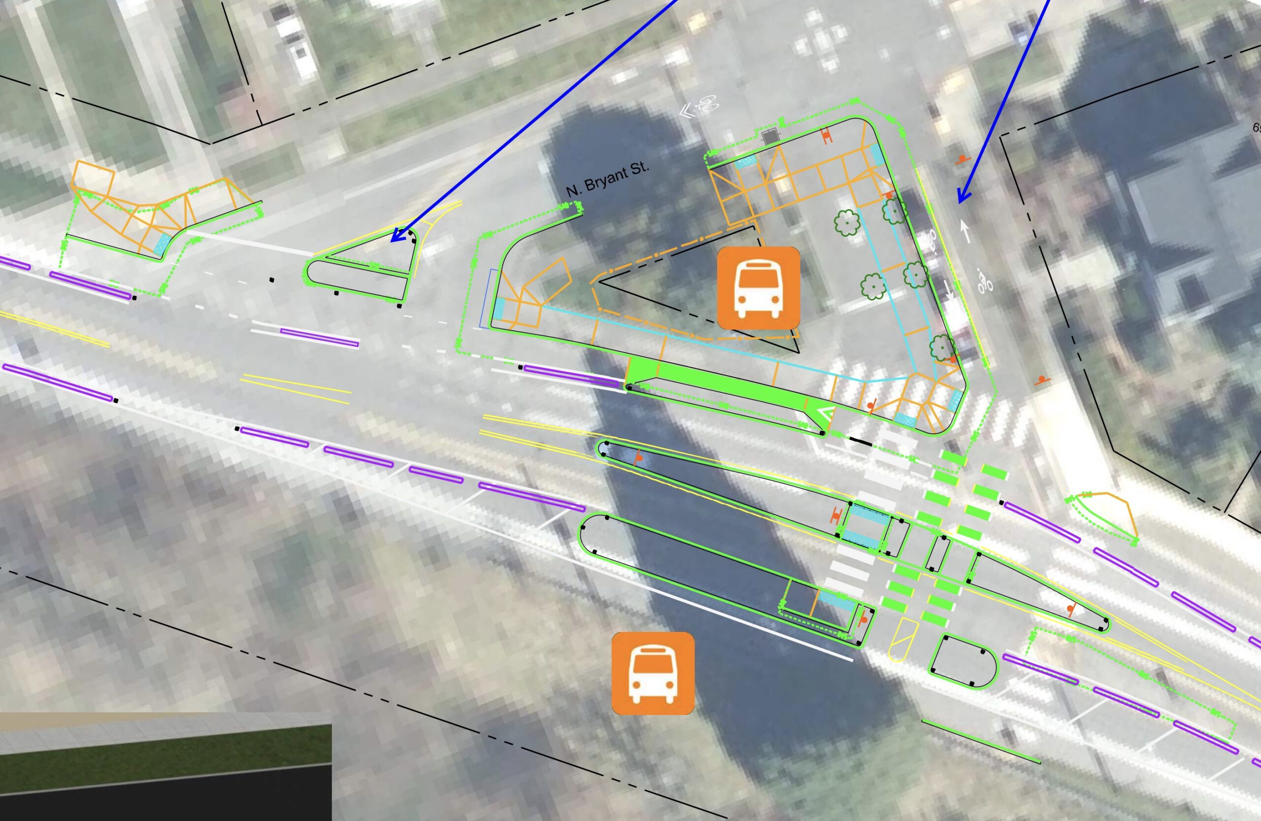
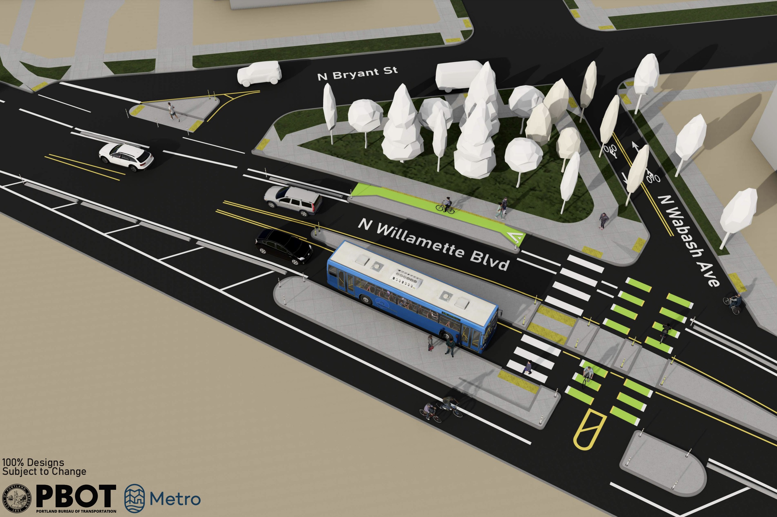
At the N Bryant/Wabash neighborhood greenway intersection, PBOT will add bus islands, prohibit car drivers from using N Wabash and add several islands and new crossings to tame traffic and invite more walking and bicycling.
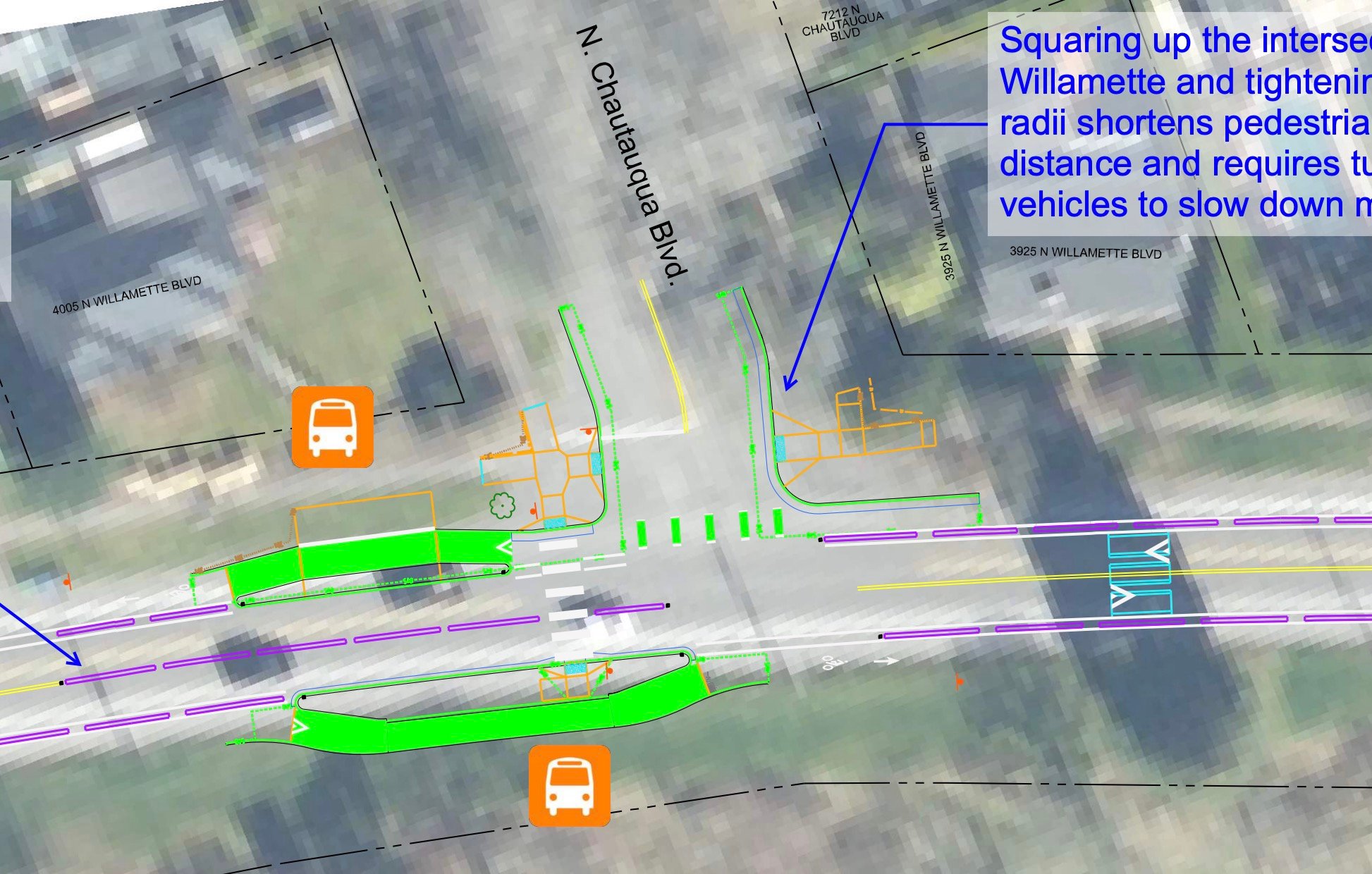
At N Chautauqua, PBOT will tighten corner radii to force drivers to slow down. They will also add concrete curbs to the centerline to prevent impatient car users from passing stopped buses and other vehicles (such as folks turning left from Willamette to Chautauqua). This is a huge improvement that is badly needed because many drivers currently dive into the bike lane whenever a driver or bus operator slows or stops at Chautauqua.
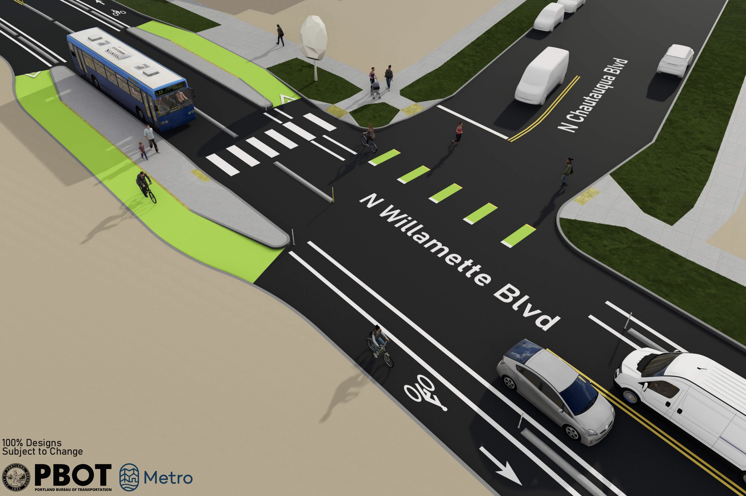
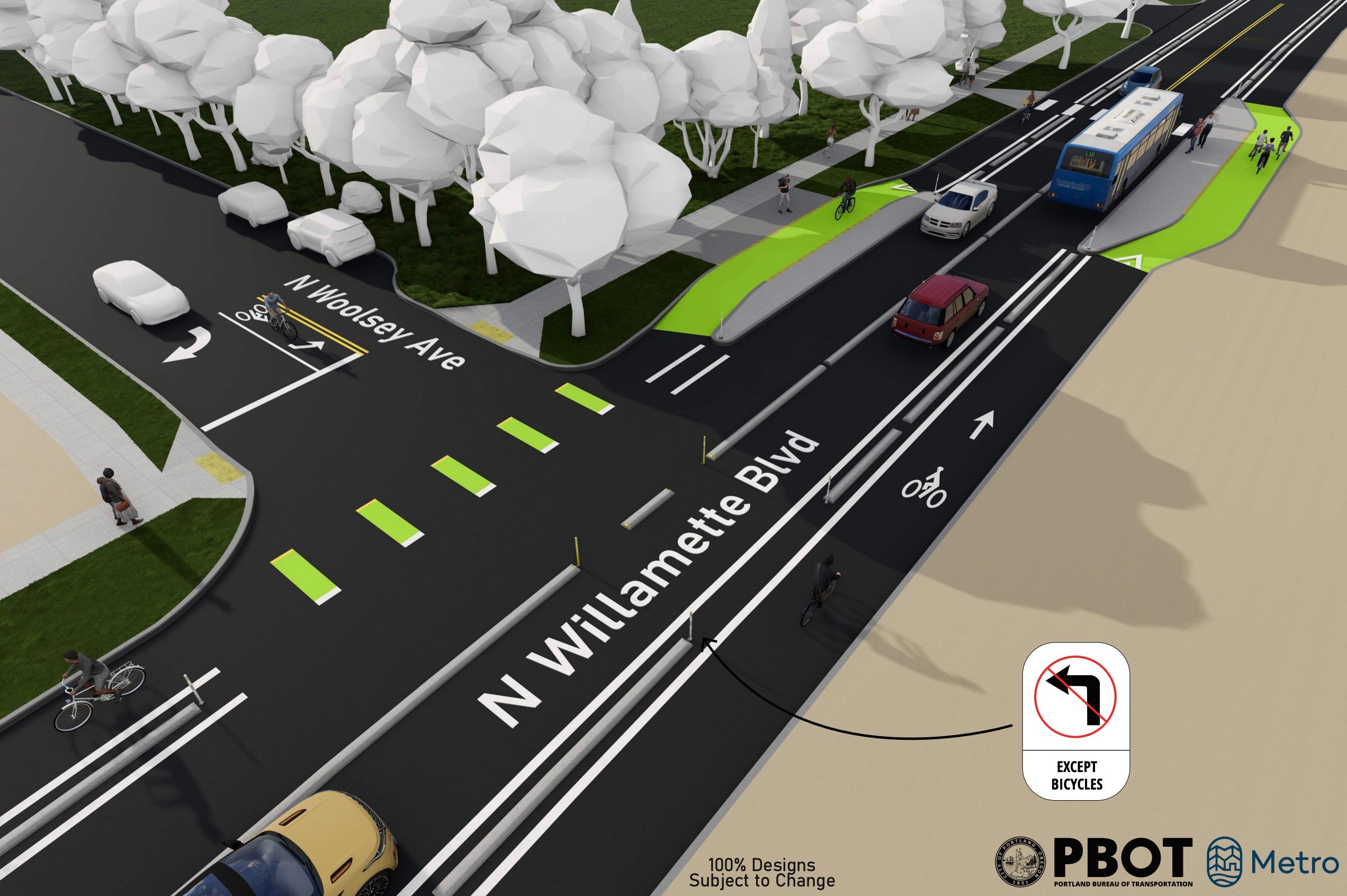
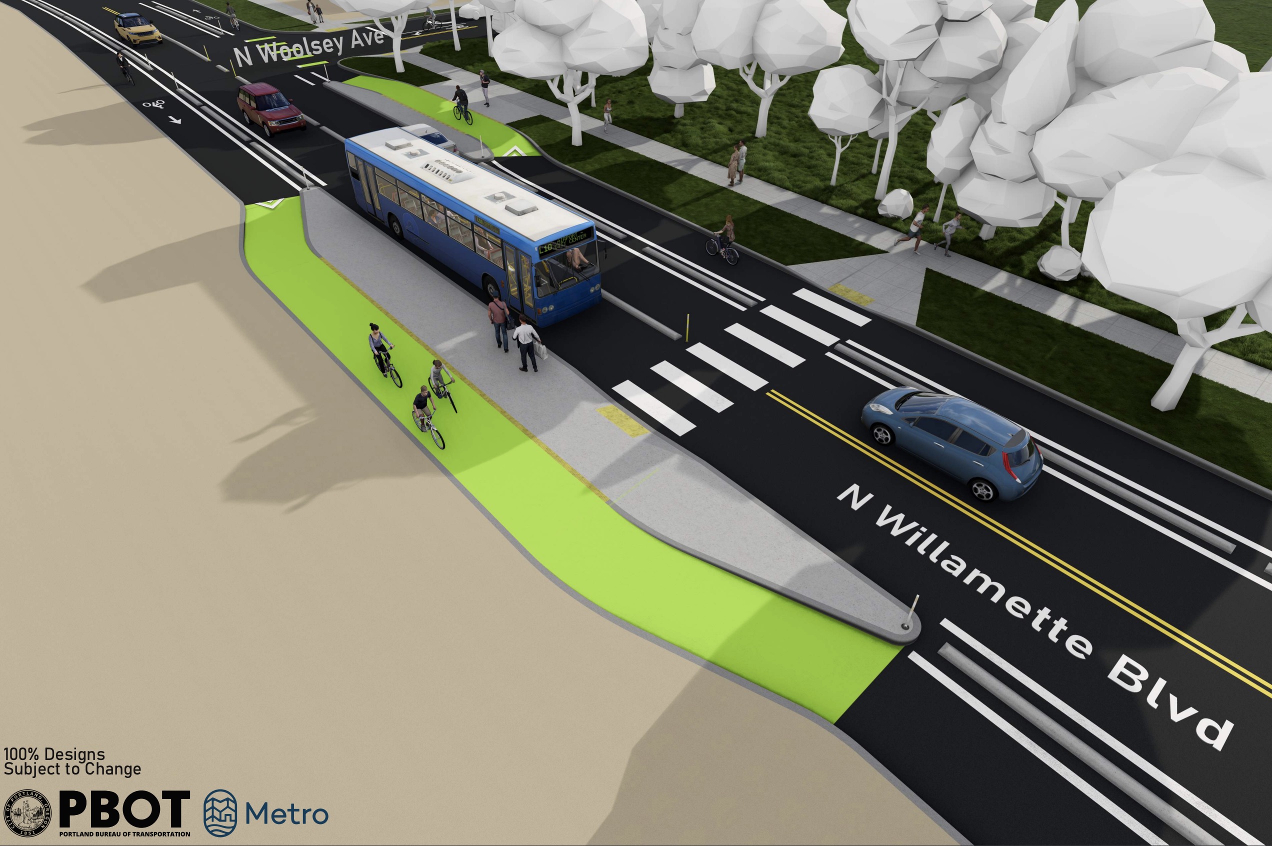
At N Woolsey (Columbia Park), PBOT will use more concrete curb dividers to prevent dangerous lane changes. And they’ll take it one step further with a new ban on left turns from Willamette to Woolsey. For drivers going south on Woolsey, they will be forced to only turn right (west) onto Willamette. This is being done due to make movement more predictable and prevent what PBOT says has been a “cluster of crashes” at the intersection in recent years.

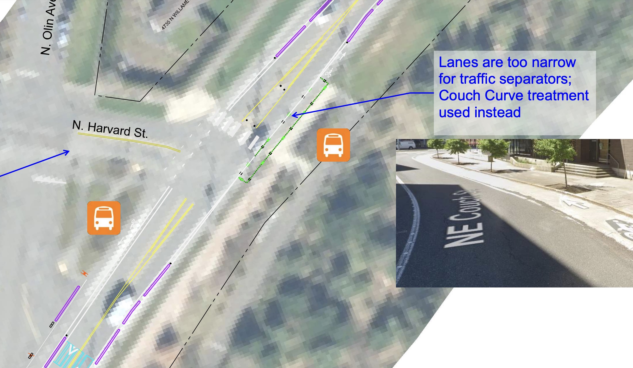
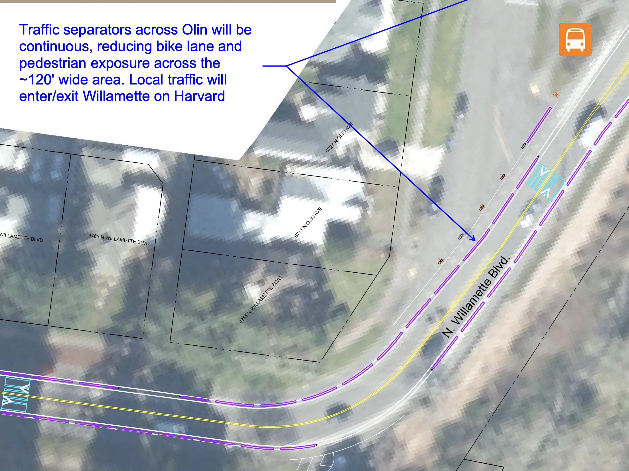
At the intersection with N Harvard (just before University of Portland curve), PBOT will raise the bike lane up (similar to NE Couch at Burnside Bridge approach) because lanes are too narrow for concrete curbs. Just after N Harvard, PBOT will prohibit drivers from accessing Willamette from N Olin and force all car traffic to use Harvard.
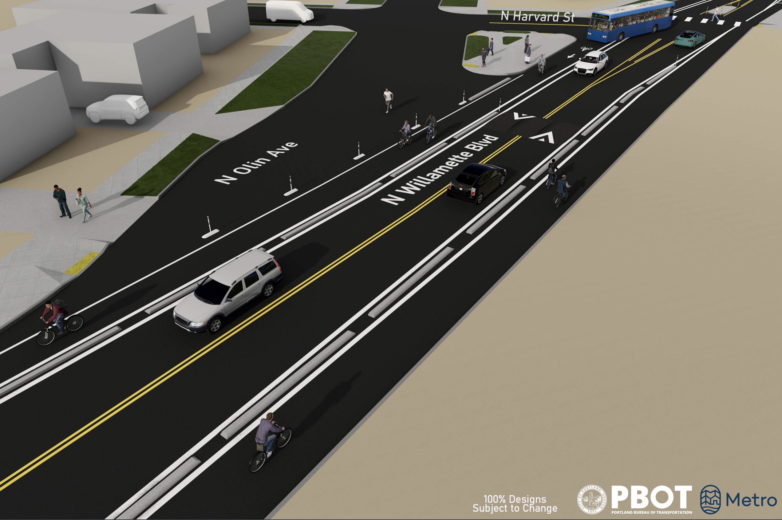
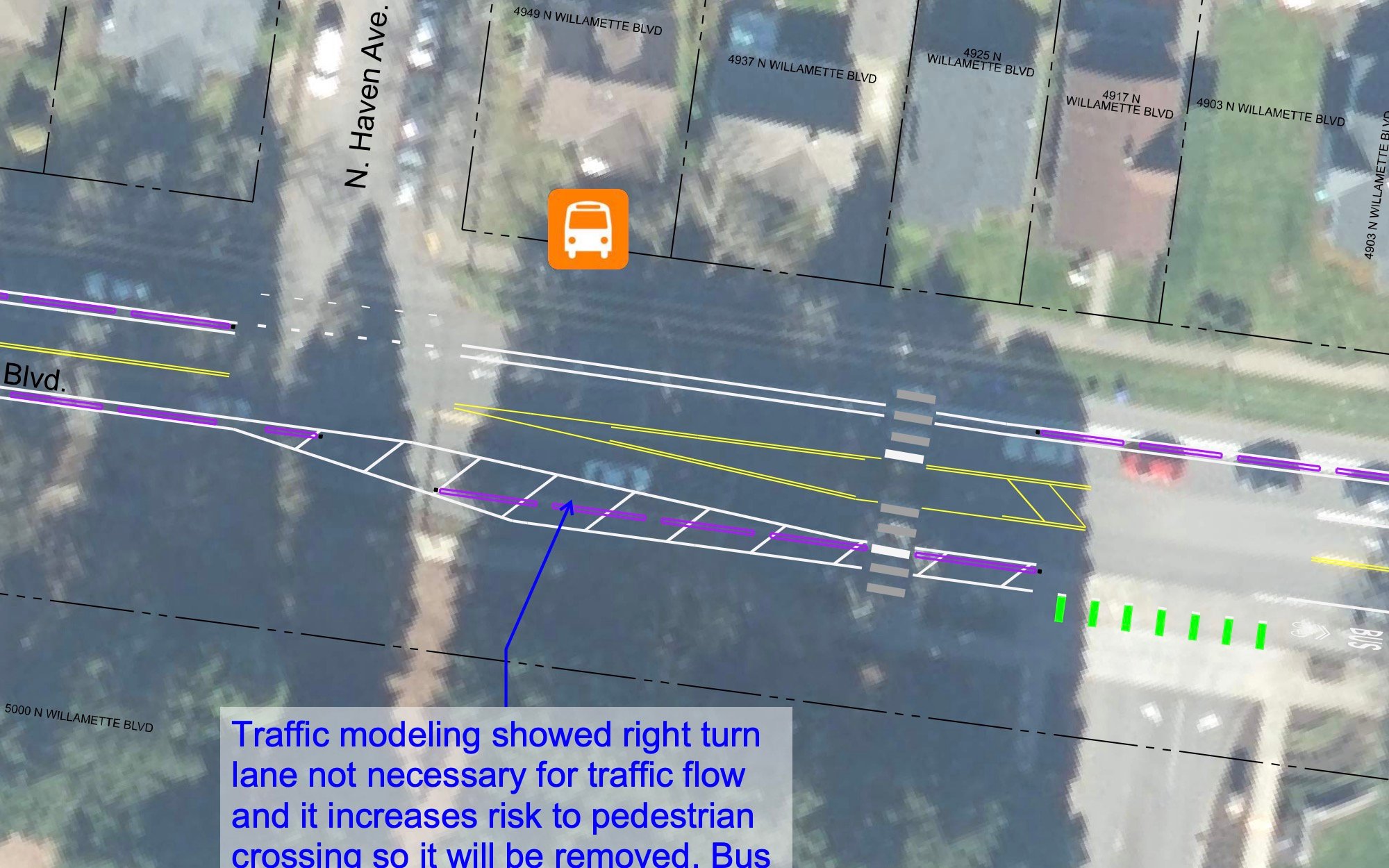
At the entrance to University of Portland near N Haven Ave, PBOT will remove one of the two southbound lanes. “Traffic modeling showed right turn lane not necessary for traffic flow and it increases risk to pedestrian crossing so it will be removed,” PBOT says.
On the bridge over the railroad (“the cut”) between N Carey and N Ida, PBOT says they cannot install concrete curbs to protect the bike lane due to bridge weight restrictions. So they’ll install plastic wands and curbs instead.
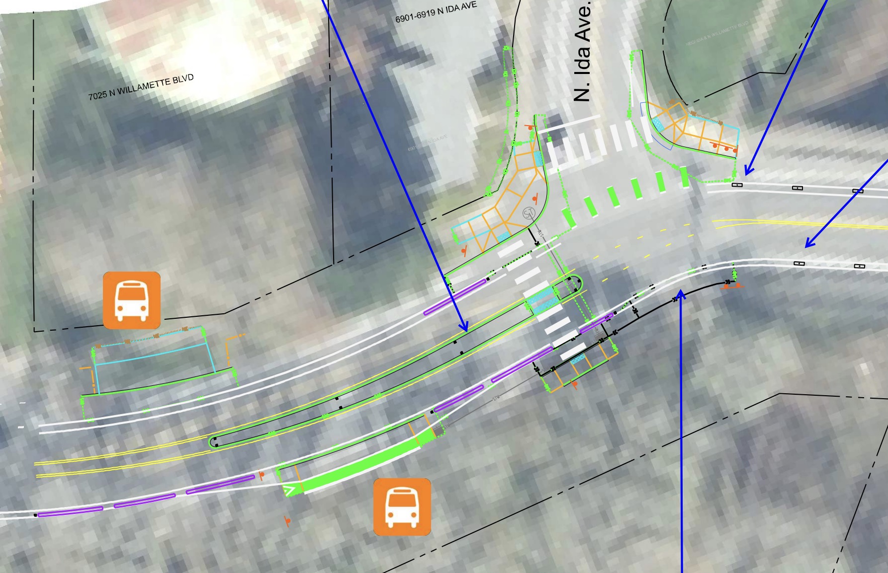
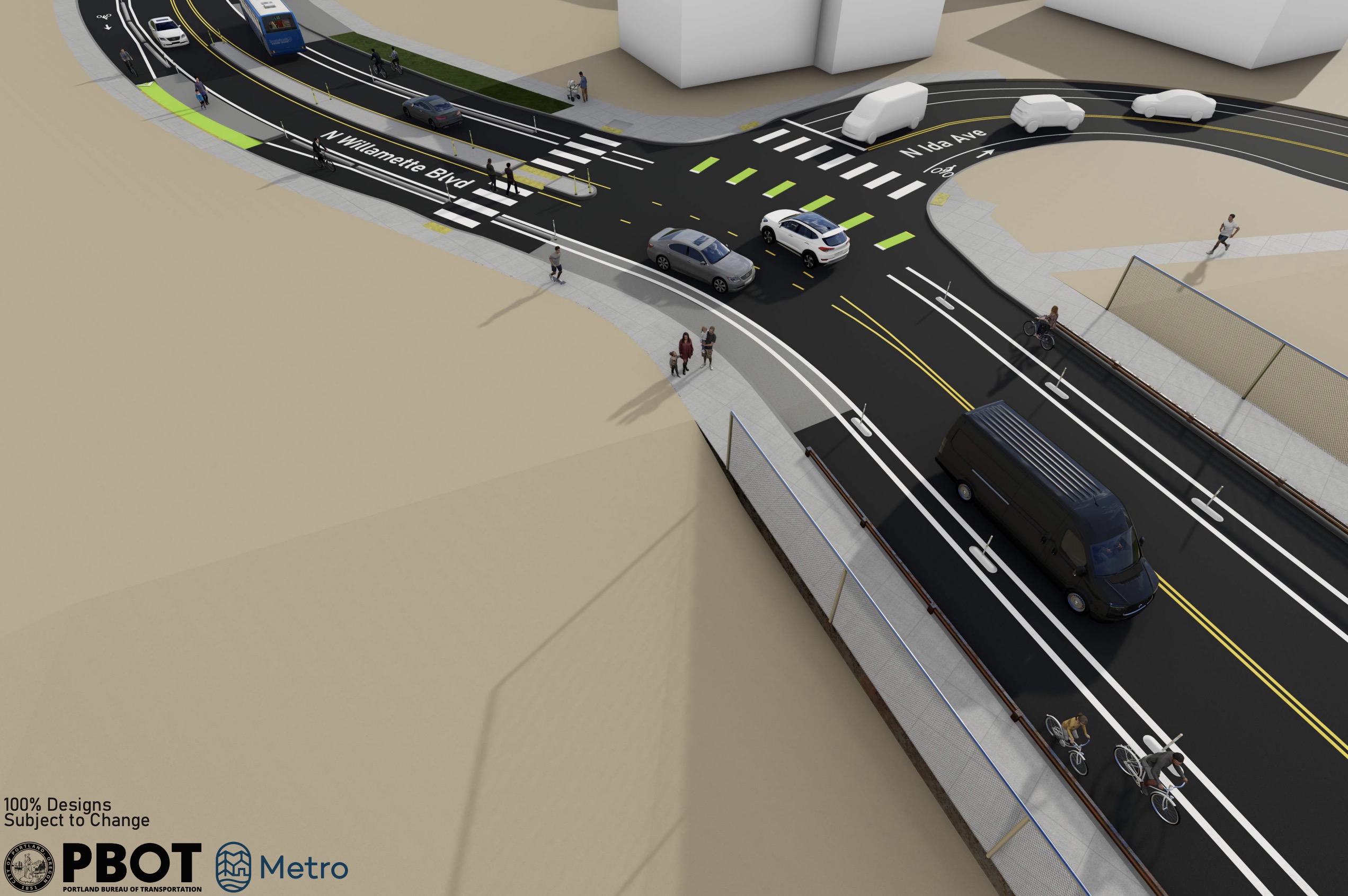
At the northbound bike lane onto N Ida (Fred Meyer, Roosevelt High School), they’ll raise the bike lane (similar to NE Couch curve). Also at N Ida, going southbound, PBOT will remove the left turn lane, improve the bus stop and add crosswalks.
I told you it was exciting!
PBOT is so proud of their designs they’re offering two online “webinar-style walkthroughs” (January 22nd and 23rd) for anyone who wants to learn more. You can sign up for those on the project website.
Construction on this project should start this summer and is expected to take 12 months to complete.


Thanks for reading.
BikePortland has served this community with independent community journalism since 2005. We rely on subscriptions from readers like you to survive. Your financial support is vital in keeping this valuable resource alive and well.
Please subscribe today to strengthen and expand our work.
Are there any updates on this project? I live on Willamette and I’m tired of all the speeding day in and day out. We were expecting things to have started by now. Any word on what the delay is?
I hear you Joe. I’m working on an update.
Meanwhile, the Halsey 68th to 92nd Ave Improvement Project continues to be continually kicked to the next construction season. I’m not salty, you’re salty!
I’ve heard tell it’s actually the railroad that’s holding the project up over some sort of right-of-way issue, but I’ve never seen anything official on that. Maybe something to put on your story list, Jonathan?
I hear you Michael. You may be talking about the under-crossing near Gateway Green. RRs are notoriously difficult when acquiring ROW.
Nope, two separate projects that are both apparently being held up by the railroads. PBOT did initially want to do the undercrossing project alongside the Halsey improvement project, but intransigence from the railroad caused costs to escalate beyond what the city was willing to fund, so they’ve put that on ice for now (going so far as to have Metro remove it from the regional transportation plan entirely, as Jonathan reported earlier this year), but the Halsey work is still supposed to go forward.
And the NE 60th MAX station area access improvements (put off for the last 3+ years), which was supposed to include a bikeway connection (removed from project). This was supposed to be a multimodal access-to-transit project and turned into the Halsey repaving project.
Yes, the 68th to 92nd improvements keep getting delayed because of the railroad. Sadly the Halsey/92nd undercrossing to Gateway Green and the I205 MUP is cancelled. Also, the overcrossing on Halsey from 92nd to Gateway is also supposed to be cancelled.
Riding over 205 on Halsey on the north side sidewalk is horrible, PBOT really needs to just take one lane of the eastbound/south side of the bridge and make it a bike lane over 205. There is a massive gap in bike network connectivity here, and the improvements on either side of the bridge will be limited by that remaining gap/missing link.
Do you know what exactly the conflict with the railroad is over? The only interaction I see is the overpass between 80th and 85th, and I don’t think PBOT is proposing any hard changes to that bridge. Why does PBOT need to negotiate with the railroads at all?
I don’t know what exactly the conflict it is, but had heard in late 2023 that the RR was an issue. These projects sure do take a long time. I think this one is taking longer as PBOT has to deal with ODOT and the RR as aspects of this project touch some of their land around the overpass. There’s the roundabout at 80th, then the bike lanes on the overpass, and they’re also improving the “path” from the west side of 82nd along the freeway fence to 81st.
map
The website has been updated with this:
“This project has been delayed until PBOT receives our agreement with the Union Pacific Railroad to move forward with construction. We’re aiming for a spring 2025 construction start, but we are not in control of the timing of the railroad agreement, and the document is a requirement for projects receiving federal funds. We will continue to provide updates as the situation progresses.”
There are a lot of property boundaries that meet around there.
1N2E29DD map
May be something to do with altering an over-crossing over RR property. In the renderings there was a grade-separated, multi-use path on the East side of the over-crossing starting at the new roundabout at 81st to 84th (which would connect to an MUP along the North side of the Eastern Cathay parking lot and the MAX/Bus). I’m a little doubtful of full grade separation for the entirety of the overpass. That’s a lot of concrete. Maybe it is just at the intersections and bollards for the remainder. It’s a smorgasbord of funding sources from PBOT, developer user fees, ODOT and Feds.
PBOT has just shown the concrete at the roundabout, and then it tapers off to the “new” 10’ wide buffered “path” over the bridge. But that path/lane just replaces the current shoulder after they take some width from the vehicle lanes and other shoulder. I would feel a lot safer if the bike “path” was protected with an actual jersey barrier or similar, as people drive really fast through here, in both directions.
I cannot be more excited about this, especially the news of the new curb profile! Quick correction: the intersection of Willamette and Wabash is with N Bryant, not N Holman.
Off the charts level of hype for these upgrades. This project is going to be such a big improvement to the experience of being on N Willamette outside a car – and to safety for everyone. I know we talk about problems a lot, but it feels good to celebrate a pretty solid win.
Most of these changes looks great! I have been waiting for this for a long time. The Rosa Parks/Willamette Intersection seems like a bad design, I would like to hear more of an explanation:
1) Why widen the road around this corner? It does not change the driving geometry to slow cars, it is likely to impact the existing Oak tree on the southwest corner of the intersection, and it introduces a bunch of unused space. Could this unused spaced space be used for 3-4 new street trees (Oregon White Oaks)?
2) The large buffer created by the road widening routes cyclist through, instead or around, the pedestrian crossing zone which is an unnecessary conflict. Many/most cyclist continue down Willamette here rather than continuing on Rosa Parks and the proposed design seems very poor for that movement.
3) Could construct the center median on Rosa Parks using 2 parallel curbs that leaves a 5′-6′ center strip of asphalt for westbound cyclists to use to make a left on to Willamette?
As someone who makes this left turn frequently, I hope something like this is included. Agree with your other assesements, too — including that overall the plans look awesome!
Has PBOT considered using the Toronto style barriers that Seattle is now using?
I hope not! Not until there is funding to keep bike lanes clear of detritus on a consistent basis.
Detritus in the bike lanes is a very real problem, but I’m not following how a Toronto style barrier would make a difference either way versus the 4″ curbs they’re proposing as part of this project?
I’m not a fan of those either but at least one could hop out into the car lane to avoid problem areas. When you’re blocked in by concrete pony walls or parked cars, navigating becomes trickier, especially in the dark. I guess I’ve just come upon this situation a lot around town and I don’t see how all the enclosed bike lanes can ever be kept as clear as a regular road way. I guess my concern is more about flat tires, hitting or avoiding random objects and unpredictable people then simply riding along a regular road next to vehicles
those look great!
I’m not sure how often PBOT is required to design emergency vehicle access. Some flex posts and the beveled design sometimes indicates that. Maybe the new design is a compromise? That few inches are a huge improvement either way.
Very exciting. And would you look at those bus stops. Great use of the space. Kudos PBOT!
The unmarked left turns seem unsafe. If PBOT is going to encourage people to make these turns by leaving gaps in the curbs, there should be more indication that people cycling could make a left (e.g. signage, crossbike, speed table) and a green turn box.
So excited to see a new bike lane curb profile !
Vertical curb for people Driving and Bevels for people Riding.
The more we can do to keep cars out of bike lanes the better !
Great news!
What is the reasoning behind the beveled curb on the bike lane side?
I’d like to hear PBOT’s answer to that also. Maybe to save on concrete? To reduce chances of a pedal hitting it?
Or maybe they left it in the details because–as everyone knows–the bevel is in the details.
I believe it is beveled so that the bike lane side remains “mountable” such that a rider could ride over the curb if needed to get out of the lane.
That makes sense.
This is the most major artery in and out of the st johns neighborhood for folks who live there. While i understand the current bike lane, anywhere from at least 4 to 6 feet, is too small and dangerous, I do not believe slowing car traffic even more(speed limit was 35, then 30, now 25 within just a few years) helps the neighborhood flourish. Blame Google maps for the idiocy of drivers avoiding lombard stop lights(which now has bike lanes). I 100% welcome no left turns at woolsey, also do the same for every major intersection (at least ones with a short distance from lombard). In my opinion this project only isolates the neighborhood even more and caves to bicycle tourists who like a pretty view.
I live in the area and travel on N Willamette a distance of ~2.5 miles one way (when I take routes that include it).
By car that takes me 5 minutes at 30 mph. Decreasing speed to 25mph increases my travel time by just 1 minute.
By bike I currently avoid most of N Willamette because of the narrow, stressful bike lanes. I instead opt for a safer route that takes me over a mile out of my way and increases my travel time by about 8-10 minutes (depending on traffic lights at Woolsey & Wabash).
I am very happy to make that trade, especially considering it’ll make the street safer for all users & quieter for residents who live directly on it (fast cars are really noisy!). There’s a serious crash on N Willamette every few months and it’s long past time action was taken to improve safety.
Let’s also not forget that N Columbia exists and provides a quick and direct connection to I-5 for drivers, which for most destinations on the East side of the river is comparable to or faster than N Willamette. Hwy 30 via St Johns bridge is consistently faster to most places in Downtown/Central City.
“But what about when there’s traffic?” – N Greeley (the primary street you connect to from N Willamette commuting into/out of St Johns) is a traffic disaster during rush hour. If anything more people having the option to bike might get a few cars off the road and make life a little better for the folks stuck in Greeley gridlock every day.
This is a common misconception at best, and a ill-intended misrepresentation at worst. Bicyclists are not “tourist” any more than drivers are “tourist.” Bicycling as a viable alternative to driving for transportation benefits all of us, including the local neighbors. No one “caves” to bicyclists any more than anyone “caves” to drivers. People do not bike on Willamette for a “pretty view” any more than people drive there for a “pretty view.” The view is nice but has nothing to do with whether you are moving through there by car, bike, foot, or flying like a spaghetti monster. So please stop.
Here here for the Pastafarians! A mode heavy on pasta carbonara.
I actually do drive on Willamette for the pretty view.
Boohoo. Dave wants to drive his car really fast on Willamette, and now he has to slow down a little bit. Poor guy.
Do you live in St. Johns Dave? Because you’re mistaken. N Lombard carries a lot more vehicles.
I for one like being able to get to my house in St. Johns in a non-convoluted way without dealing with with distracted motorists veering into the gutter lane or needing to take side streets to feel safe.
Please don’t pretend that car-centric infrastructure addresses our ‘isolation’. We have more than enough roads to and from St. Johns. I can be downtown in 20 minutes in a car. Its our god awful bike infrastructure and transit options that really isolate us.
The pretty view is a bonus though!
Man, I get one serious reply(thank you Matt), one calling me a snowflake, one shredding my use of 2 singled out words, cos it was upsetting? and one who clearly does not live in St johns but is accusing me of not living in St johns(maybe they just pass thru on the CC rider i can’t tell).
Look, I’ve lived here a long time, I’m not trying to discredit bicyclists and the need for safe bike lanes et al. I’ve commuted by bike, the 44, the 16(previously the 17), the 75, car and carpool and I understand so calm down sheesh. Over the years I’ve seen a lot of asinine projects in this neighborhood that have not helped car drivers, bicyclists, pedestrians or transit riders. I can’t say for sure this is one of those cause it hasn’t happened yet, but check back in a year and show me I’m wrong and I’ll cave.
I’m leaving this site after this comment so yall can have your echo chamber back. ✌️
Who accused you of not living in St. Johns? I asked if you lived in St. Johns.
I was only asking because N Willamette is obviously not the main artery into St. Johns from the rest of the city, so I just assumed you were unfamiliar with the peninsula. Lombard literally takes motorists into the hear of St. Johns.
So, do you live in St. Johns?
I lived in St Johns for several years. It was ridiculously easy to get anywhere in Portland by car. I primarily commuted by bike and bus. But it was always faster to drive anywhere at any hour of the day. That’s why I find it laughable to hear complaints about proposals for improved bike infrastructure to link St Johns with the rest of the city and make biking safer and less stressful. Driving will still be, by far, the fastest and easiest transportation mode on Willamette Blvd after this project is complete.
I appreciate that you focus on St. Johns’ residents, since “folks who live there” are the ones that have to deal with traffic design consequences 24/7. That said, I bet most residents would like a quieter and safer (for everyone- drivers and non-drivers alike) thoroughfare. I’m using my experience in Sullivan’s Gulch as an example. We have an absolutely highway-hellscape in the Broadway-Weidler couplet. The Neighborhood (residents) have been trying for over 30-years (check the 1996 plan, updated in 2019) to get those roads dieted down for better livability. Getting this N Willamette design would be a god-send. I imagine St. Johns folks are not that different from Gulch folks…
And, If we do want to throw businesses a bone, the additional transportation modalities (and tourists, as you say), will provide a boost to businesses. I, for one, can’t wait to bike up to Sparrow Bakery along this route!
Looks great! Thanks for the update!
Traffic separator height is identical in old and new design styles (4”)
getting rid of the bevel on the driving side will make very little difference. Car tire sleeping getting bigger with extreme sizes on cars like the cybertruck and rivian. But even a crosstrek could roll right over that little curb.
I can hardly wait for this to be completed! I live in and so ride in this area almost daily. One thing I would love as it’s completed is some early traffic enforcement to discourage drivers who will immediately try to drive around all the new changes.
Not allowing left turns from Willamette onto Woolsey is a such a win. Motorist illegally drive in the bike lane all the time there to get around left-turning motorists.
Its been a long time since I’ve seen a PBOT bike project that looks pretty safe/complete.
“Ye are the light of the world. A city that is set on an hill cannot be hid.
Neither do men light a candle, and put it under a bushel, but on a candlestick; and it giveth light unto all that are in the house.
Let your light so shine before men, that they may see your good works…”
This is awesome! I bike this route all the time and am excited to see the improvements!
I think the first word quoted should read many, but the original does gibe with my experience of all drivers who have cut around me when I make that turn having presented as male.
This project has been such a long time coming! My entire journey of accessing biking for transportation was based on my experiences on Willamette Blvd. From being up at UP starting in 2013, then commuting when I worked at Chipotle in the Pearl from Portsmouth, then interning at the company I still work for today from University Park: it’s all been along Willamette Blvd.
Shout out to the PBOT team who’s been working on this (Mike Serritella, and Dave Backes) and anyone else who’s had a role in shaping this project. For once it feels like a project that didn’t have to give an inch to appease the convenience of driving. We still have a long way to go to hit equilibrium to meet our mode share goals, but this has to be one of the biggest steps I’ve seen since recently.
As a University Park dweller and someone who either walks, bikes or drives on Willamette every single day, I’m very excited for this project.
I was a tad concerned seeing cars wouldn’t be able to turn left onto Willamette from Woolsey, but seeing that all the UP neighborhood streets that intersect Willamette (e.g. Menlo, Harvard, Wellesley) allow left turns, I think it’s a great thing because hopefully it’ll reduce folks cutting over from Lombard (hopefully it doesn’t have the adverse unwanted effect of Lombard drivers speeding through UP to cut over to Willamette).
Only concern I have is if cars can’t turn left onto Willamette from Woolsey there’s going to be a lot more cars turning left from Chautauqua and it might’ve made sense to include a light there because that’s gonna be a mess. Otherwise, looks amazing and really excited to bike on Willamette without worrying that a car will swerve into the bike lane to get around someone turning left.
High fives to the North Portland in Motion team that secured funding for this project. The neighborhoods clearly identified this corridor as a top priority for safety improvements, and the PBOT team listened.
Can’t wait to see this get built.
So I missed this article by six months… never too late to comment! We’ve lived on North Willamette near Portsmouth since 1992 and have had the unfortunately pleasure of at least six drivers crashing into our front yard, our neighbor’s yards, various street tress and fire hydrants and side-swiping parked cars on just our block over the years. I dutifully provided photos of the string of crashes to the project design teem. I’ve been collecting them since the first Willamette Blvd traffic calming project went down in flames in the late 1990s, thanks to a small band of angry, mostly elderly proto-MAGA people and a complicit Portland Fire Bureau. A lot of good work went down the drain and several cyclists and walkers have been needlessly killed or seriously injured since.
That’s why I love this plan, and why it has the support of many of our longtime neighbors. It’s long overdue and will make a real difference in saving lives and giving people the freedom to walk and bike safely on our beautiful street. It was also really helpful to have the Rosa Parks project put a face on what a safe design can look like — another great project that I supported when it was in the planning phases, and that I think persuaded a few skeptical neighbors on the merits of the Willamette Blvd project.
I do agree with the above comments on the left-turn being eliminated at Woolsey (Columbia Park Annex). That’s a very common traffic movement, since there’s a signal at Woolsey and Lombard. I’m going to guess that the unintended consequence will be traffic cutting through on Wayland, Foss and Hurst to make the same switch from Willamette southbound to Lombard eastbound — I hope not. Otherwise, a really well-thought-out plan!
Thanks for the detailed coverage of the project, Jonathan. As of today, PBOT is estimating the project will break ground as early as next month, with a one-year construction window. Exciting!
Enough with the speed bumps already people on their scooters and bikes can already go faster than cars
amazing! the first rendering (at N Woolsey) is where i had my first car-on-me-on-bike accident in 2011. i’m SO excited for bike-aware blvd changes.