A team of Portland State University urban planning graduate students has completed a report on the future of Sandy Boulevard. Their plan seeks to rescue the diagonal arterial from its notorious reputation and turn it into a destination.
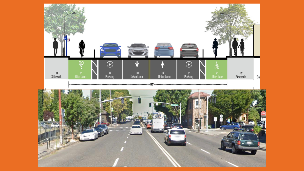
Their recommendation: swap two existing on-street parking lanes for bike lanes and get rid of two general travel lanes to make room for two bike-only travel lanes that are physically protected from other road users.
Despite its 60-foot wide profile, Sandy Blvd currently has no dedicated space for bicycling. It has long been eyed for a bikeway due to its diagonal alignment that could provide convenient, efficient access to many destinations and other facilities in the bike network in a fraction of the time it takes riders to navigate around it.
With a full repaving project scheduled by the Portland Bureau of Transportation in 2026, nonprofit bike advocacy organization BikeLoud PDX worked with Strategic Minds Consulting Group, made up of five PSU Masters of Urban Planning (MURP) graduates who took on the project as part of their MURP workshop. The group has worked since January to research the stretch of the road between 14th and 28th. They held open houses, hosted interviews and surveys. They also came to events like Bike Happy Hour to present the project and collect feedback.
Strategic Minds released their existing conditions report back in May. Their final report calls for two 10-foot wide bike lanes — wide enough for a seven-foot lane and a three-foot buffer zone. Here’s more from the report:
“This alternative allows existing parking lanes to be maintained on both sides of the street, providing a further barrier of protection between the bike lane and moving vehicle traffic. Cyclists would be unprotected by parking at intersections, driveways, and areas where the roadway narrows to the extent that parking cannot be accommodated, mostly due to left turn lanes, bus stops, and pedestrian crossing curb extensions. In these areas, the bike lane would be separated from vehicle traffic with a 3’ physical barrier. Currently, pedestrians crossing Sandy must cross four lanes of moving vehicle traffic. This alternative would shorten the crossing distance to two lanes of moving traffic, increasing safety and comfort for pedestrians.”


The project team shared several justifications for their recommendation. Fewer lanes for car users will effectively narrow the driving space and lead to slower speeds overall, thus making it safer for everyone. Removal of two driving lanes will also make crossing Sandy much easier and safer. Their recommendation also aligns with Portland’s adopted Vision Zero goal, which specifically calls for a “safe systems” approach that includes road diets.
Strategic Minds also found broad public support for this change. “Engaged community members also put a strong emphasis on wanting Sandy Boulevard to be a pleasant place to spend time,” the report reads. “Rather than just a freeway bypass.” And from a business and economic development perspective, when Sandy Blvd is a quieter, safer place with capacity for more people (not just more cars), folks will be more likely to spend time on the street. And in economic terms, that means businesses could see more customers and larger receipts.
The project team says PBOT should consider a temporary demonstration project to test out this new configuration before the street is repaved. PBOT should be open to the idea since the agency once sought a grant to do a similar report of their own back in 2020.
In their detailed recommendation, the project team also shared how they’d approach a bus priority lane and shared ideas for how to transform several intersections along Sandy Blvd with traffic calming methods to make it safer and more human-scale.
While the project team reported latent bicycling demand and general popularity for changes like this, they also found some residents and business owners who are concerned about how it would impact parking. “The perceived shortage of parking, as well as the potential removal of existing spaces were frequently mentioned,” reads the report. “Community members expressed concerns that new apartment complexes without parking facilities would worsen the neighborhood’s parking situation.”
— Read the Future Sandy Final Report here.


Thanks for reading.
BikePortland has served this community with independent community journalism since 2005. We rely on subscriptions from readers like you to survive. Your financial support is vital in keeping this valuable resource alive and well.
Please subscribe today to strengthen and expand our work.
In contrast to most of the inner eastside arterials, NE Sandy is designated as a Major City Bikeway in the Transportation System Plan. That was a decision that was made during the 2035 Comprehensive Plan process, after a lot of discussion at then then-Planning & Sustainability Commission, in order to force a conversation about how to accommodate bicycles on Sandy.
This decision about how to move forward will be an interesting test of how PBOT will interact with the new form of government. In the past, decisions like this would be made by the Commissioner-in-Charge, with little to no input from the public. When talking to PBOT staff about they’re not implementing projects clearly called for in the own plans, they’ll bluntly say that they don’t have support from their Commissioner-in-Charge.
With the new form of government, there’s an opportunity for PBOT to publish a report, and bring it to council as an agenda item. Right now we have no idea who will be on the new council, but it’s certainly possible (likely?) that it will skew more bike friendly than recent Commissioners have been.
I think this would be awesome. However, PBOT would surely raise concerns that bike lanes could cause 15 seconds of delay to the 12 bus line, or impede the possible future expansion of streetcars. Therefore, we can’t have bike lanes on Sandy.
Commenters on this site will surely argue that there are tangential neighborhood greenways less than a mile away from parts of Sandy. Therefore, you’d be crazy to want to bike on Sandy. Any sane cyclist, they’ll argue, would opt for multiple miles of out of direction travel instead of riding on a bike lane that directly accesses destinations.
This would impact the 12, 19, and 20 buses, and it would be a lot more than 15 seconds. This is all meaningless without traffic estimates.
Those three buses are only combined on Sandy Blvd for a mere two blocks, from 14th to 16th Ave. Then there are two buses from 16th to 22nd/Glisan. Then there is only one bus running every 15 minutes. So maybe there could be shared bus/bike lanes for the western part, and just bike lanes for the eastern part. I’m sure there is a way to balance these things.
Meaningless compare to the time these routes already spend sitting behind private motor vehicles
Meaningful for the thousands of commuters who ride these frequent bus lines.
I’m sure people will be tempted to compare this to Hawthorne, and it seems you are implying that there. But it’s extremely different:
–The 12 bus has less ridership and lower frequency than Line 14, and doesn’t serve as many high-equity areas
–The delay issue for the Line 14 on Hawthorne was entirely around the Chavez intersection, whereas Sandy Blvd in this stretch doesn’t have any cross street intersections anywhere near as busy as Chavez
–Sandy Blvd is a diagonal street with no parallel routes, whereas Hawthorne Blvd is an east-west street with parallel neighborhood greenways on both sides of it
–Hawthorne runs into Mt Tabor and so it was never going to be a popular longer-distance bike commuter route, whereas Sandy Blvd could someday be a longer-distance bike commuter route because it just keeps going and going.
–Sandy is a Major City Bikeway in the city’s transportation plan and the regional transportation plan, whereas Hawthorne was not identified as a Major bikeway in either of those plans.
–Hawthorne is a more traditional main street that relies more on on-street parking and loading than Sandy Blvd, and also has narrower sidewalks than Sandy, so the parking next to the curb sort of acts as a buffer for pedestrians.
–I think there’s a lot more community and advocate support for bike lanes on Sandy, and have been for a long time, versus Hawthorne which was more divided.
–This effort has the benefit of being championed by BikeLoud and other organizations already, and supported by this PSU project, whereas the whole advocacy effort around Hawthorne was largely the work of a “lone wolf” activist Zach Katz, who alienated both bike advocates and businesses, totally misrepresented businesses’ support for the idea (he would get an employee to sign on and then say the “business” supported it), and really sabotaged his own cause by not working in a collaborative way with existing advocate and community groups.
They could have easily installed bike lanes on Hawthorne and put in a mixed bus/bike lane at Cesar Chavez (like what there is today), thereby avoiding any bus delays. You can’t pin Hawthorne on Katz. PBOT was looking for excuses to not put in a bike lane from the get go.
1.) Hawthorne is ped and transit priority street, not a major bikeway.
2.) Portland’s transit mode share is currently growing faster relative to total mode share than any other mode. (Relative to total mode share cycling’s growth is stagnant.)
3.) Transit mode share is more than double that of cycling.
4.) Transit riders also deserve access to shopping areas and do not deserve to have their major and heavily routes diverted to toxic and unsafe arterial highways.
5.) Transit serves many for whom cycling is not a good option and disproportionately serves communities of concern.
Fixed it for you:
There’s no reason there couldn’t be buses and bikes on Hawthorne. There’s room for bike lanes if you take out center medians and turn lanes. The only way you’re getting continuous bus lanes (I.e. Rose lanes) is by eliminating ALL of the parking. I would love to see that. But that seems like a more difficult lift.
The problem with the bike lane scenario is that there isn’t room for both substantial ped improvements and a protected bike lane. Recall that this is a ped priority street and not a major bikeway.
I’m fine with eliminating it all but it’s simply not true that “ALL of the parking” would have to be eliminated. Parking on one side could have been preserved while still leaving space for two rose lanes and substantial Ped improvements. Even if the cowardly PBOT/council status quo deemed rose lanes impossible it is still important to save space for expansion of the sidewalk which is grossly insufficient for a major pedestrian business area.
Fun to see my name being slandered again on here. I love a good scandal as much as anyone, but that narrative is comically exaggerated.
Yeah, there were a few businesses where employees claimed they could speak to the owner’s opinion and ended up being wrong, but 99% of the people I spoke to were business owners.
Regarding advocacy/community groups, it’s not that I alienated them; keep in mind this was all happening during the very beginning of the pandemic, so most of them had about 100 priorities higher than fighting for a bike lane (i.e. keeping the lights on). BikeLoud in particular’s organizational capacity was a fraction of what it was today; they’ve done an amazing job growing since then!
Finally, some other community groups had the capacity but simply were against bike lanes. Think NIMBY neighborhood associations, etc.
I really strived to run a good, honest campaign. I wasn’t doing it for the money nor recognition; it was pure passion. If you want to believe otherwise, that’s your prerogative.
I’m glad to see that you’re really taking criticism to heart and doing some healthy self-reflection and learning to become a better person…oh, no, wait, you’re just being defensive.
You mentioned NA opposition: did either Sunnyside or Richmond take a position on bike lanes?
How much does car traffic impact bus travel times?
A LOT!!
Generally you can put in 2-lane road diets if the ADT (average daily traffic) counts are under 9,000, which is the case for most of Sandy, but it gets over 12,000 around I-84.
https://pdx.maps.arcgis.com/apps/webappviewer/index.html?id=7ce8d1f5053141f1bc0f5bd7905351e6
In 2019, according to the map you linked. What are the numbers like today, I wonder.
Probably lower! The rise in working from home post-Covid has reduced a lot of traffic, especially morning traffic inbound to the city center. Afternoon traffic is still usually high, but more spread out in both directions because a lot of it is people running errands or going to events after work, rather than it just being commuters.
Basically there is about double the traffic in the Hollywood area, or in other words about half the traffic disappears right at I-84 and then Sandy has way less traffic from I-84 to the city center. So focusing on this area really makes a lot of sense as a starting point for a road diet and bike lanes.
You must be looking at only one direction at a time. They’re listed separately! My recollection is that ADT is more like 24,000 in the Hollywood area, maybe higher, and 16,000 in the Kerns neighborhood where this report is focused on.
That’s right, I was looking only in one direction at a time. According to my friendly local traffic engineers here in NC, a single lane of continuous traffic can handle around 9,000 vehicles per day without getting into “grade-F” traffic congestion except at certain AM and PM peak periods and during special events. Those sections regularly getting more than that need to have traffic congestion mitigated somehow, either by providing alternative routes, extra lanes, or by reducing demand (TDM), or else emergency services suffer as do transit connections and run times.
A lot of that is cut-through traffic that should be encouraged to get on 84 or 205 earlier.
I live in a nearby neighborhood and talked to someone from PBOT about all the Rose City golf course drama and a major portion of that traffic come all the way up from Powell to get to highway 30.
The ultimate problem is that a lot of motorists these days navigate by phone, so when traffic congestion apps show less traffic on back streets, they’ll take them instead of main streets like 82nd, let alone highways like I-205. So any stroad-diet like what is being proposed MUST be accompanied by a substantial stroadway diverter strategy too, for cross stroads and other local through-ways, to mitigate cross-town congestion.
I’ll take a hypotenuse over the opposite + adjacent sides of a right triangle, all things being equal!
I wonder if the bus issue might be pretty easy to mitigate. Since there is parking and physical protection, there would be plenty of room for a bus stop as well as one of those raised loading platform thingies like on Hawthorn by Ladds. I know, groan, they’re not perfect but they’re like one speed bump. I’ll take it. It should add zero (0) seconds to the bus travel time.
(I read your comment as talking about hypothetical people, and I’m rebutting the hypothetical arguments)
Side note though, on the occasions I’ve been on Sandy, I’ve seen a lot of restaurants and shops that I was interested in checking out, yet I never do by bike because I’m on some side road behind them. I don’t even remember they’re there.
I agree, doing SOMETHING for better non-car transit is basically always a good thing. It should be everything vs. cars rather infighting
Do any of the resident tea leaf readers want to comment on the likelihood of something like this getting adopted? I would obviously love this…. but these are just the recommendations of an academic project. Seems to me (as Home alludes) the city could easily find excuses to disregard the work and do whatever they would do absent this report. Are public comments useful to make it more difficult for the city to ignore this kind of work?
I would rate the probability of getting some sort of bike facility on Sandy as being “likely” the next time the street is overhauled. The city is generally moving towards reducing lanes on facilities, and Sandy, being diagonal, makes a great bike route for a lot of trips.
It’s actually not awful today, at least off-peak, but I understand why people might avoid it.
Thanks, Watts! I don’t currently think of Sandy as a natural bike route — I’ll have to go ride it! I have been looking for a good way to get from the 205 path to inner SE without going all the way S to Springwater….
Yes, you can submit testimony to City Council, City Budget Office, Planning Commission (Map App), etc. and attach a PDF such as the MURP study and petition to invest in safe streets for all people. Do it regularly, consistently, and in coordination with multiple constituents and it will be difficult for your elected public officials to ignore.
City Council Agenda, Click Submit Written Testimony
https://www.portland.gov/council/agenda
Portland Map App, Click View Proposal and Testify
https://www.portlandmaps.com/bps/mapapp/
City Budget Office, Written Testimony to Council is via Map App
https://www.portland.gov/cbo/join#toc-written-comments
Thanks for the links.
Oh gosh – when I see a bike lane trapped between the curb and a lane of parked cares, I panic. When I lived in Seattle, the city built several of these and I had many close calls of getting doored, not to mention pedestrians standing in the bike lane because they perceive it as an extension of the sidewalk. As a rider, I’m much more likely to ride in the traffic lane than ride in a bike lane that is walled in by parked cars.
I’d be curious if there is data on the safety of this kind of format compared to other layouts.
PBOT seemingly so far has been pretty good about having a buffer between parked cars and bike lanes. See Broadway and inner Hawthorne.
Especially on Sandy Blvd, with the many awkward, angled intersections. The right hook/left hook risk is going to be significantly higher.
The parking protected bike lane on Broadway works well, with the exception of the stretch in front of the heathman hotel (due to out of town people at the valet stand) and schnitzel concert hall (when there are major evening events). I too fear getting doored or run into by people exiting cars. But they seem to work okay from my perspective.
When done correctly PBLs are vastly safer than standard lanes or none. This is the gold standard in most countries in the EU, Canada and a few others. The caveat is “done safely.” A lot of DOTs in the US cut corners, literally. The most important part is daylighting intersections and designing for a 90 degree turn for cars. Unfortunately, both are rarely done in the US.
Amen — being trapped in an invisible location with no room for evasion is not a great place to be riding a bike.
Hard disagree. If I get doored in a traditional bike lane, I get sent flying into traffic. The risk of getting doored there is much higher, because – for the time being anyway – 100% of cars have drivers. There’s also the risk of people pulling into and out of parking spots, and Uber drivers putting on their flashers and double parking.
In contrast, parking-protected bike lanes make me feel a ton safer because not only is there now physical protection between my body and fast-moving cars, but the chance of getting doored goes way down given how few cars are carrying passengers. In the unlikely event that I do get doored, at least I’m going on the sidewalk or bike lane instead of into the grill of an SUV doing 15 over the speed limit. As others have mentioned, PBOT does a pretty good job of having a buffer between parked cars and the bike lane to mitigate the risk even further.
In regard to getting left/right hooked – usually there’s a clear zone around intersections to improve visibility, and someone who isn’t looking for a cyclist in a parking-protected bike lane isn’t looking for one in a traditional door-zone bike lane either. At least parking protected bike lanes tighten the turning radius and make cars slow down a bit. Look over your shoulder at every intersection; that’s the only way to really mitigate that risk.
When it comes to those pesky pedestrians standing in the bike lane, IDK, get a bell and pay attention? I see maybe 1 or 2 people a week standing in the bike lane and when I ring my bell they move 99% of the time. It’s just not that big of a deal.
You would rather be between parked cars and moving traffic than parked cars and a pedestrian walkway?? I must have moved from Seattle before the PBLs went in, because I don’t have any recollection of them. I do vividly remember the fear of getting doored almost everywhere in Seattle, and I would have felt a lot better on the passenger side of the cars.
A couple of points to consider: passengers are not at all habituated to checking for cyclists coming before they open their doors (many drivers aren’t either, but some are). You’re riding in a slot between parked cars and a curb, in an area that many people think of (incorrectly) as an extension of the sidewalk. If you need to momentarily leave that area to evade something, you’ve got nowhere to go. When you come to an intersection, a driver turning across your path may not expect you because you were hidden previously and “appear out of nowhere”, creating a danger of hooks from a less attentive driver.
When you are on a moving vehicle, I think it is safest to be in the place where everyone expects moving vehicles to be, not where they instinctively think there will be none. Surprise!
Speed also makes a difference, which is why Broadway, going uphill, works reasonably ok (and is a huge improvement over what was there before), whereas SE 2nd, going down, has some tricky spots at intersections.
Many people here disagree, and I think those opinions are valid, but I personally share Erin’s concerns.
It probably doesn’t help that the premier example of parking protected lanes in downtown Seattle sucks to ride on for other reasons, such as signal timing.
I don’t think we need to the painted “rainbow road”. Painted surfaces especially on wet days don’t seem very safe anyway.
strongly strongly disagree. The current one that’s been on SE Ankeny has worked without any problems for a few years now.
As long as the PBOT technicians remember to mix the grit into the thermoplastic (remember the Williams avenue debacle?).
It’s worked without any problems for people who frequent bars on either side of a constricted lane and who mostly drive to this area. However, it’s not worked without any problems when I use the Ankeney bike route during peak evening hours and the “plaza” is crowded with tipsy car drivers.
Is this mostly an annoyance versus a big deal? Yes.
Do I find it annoying enough that I avoid this area by using Couch some of the time. Absolutely.
yeah you’re right there are some problems with it for sure. There is way too much car access possible and I wish PBOT would figure a way to make that better. But we were talking about paint slipperyness specifically here, and in that regard, it’s fine.
Are you telling me the Graphic design lead did that rendering of NE flanders?
MS Paint.
Damn it, Jim, I’m a doctor, not an artist!
Did the report have a recommended layout of the lanes if they included a streetcar on sandy?
Streetcars run in travel lanes, so it’s the exact same cross-section whether there is streetcar or not.