
StreetsPDX is up and running! And to be honest, I’ve got mixed feelings.
All that information I spent years and hundreds of hours poking around internet for—street classifications, the public works review process, early assistance, required development improvements—is now conveniently and attractively packaged in one location. Hey, I had to earn that knowledge the hard way! Now, any Joe Blow can easily access it.
Joking aside, StreetsPDX (formerly called Streets 2035) is great. A web page for people who wonder how decisions about using the right-of-way are made. Why no street trees here? Can’t a sidewalk go there? How about a median?
It’s a decision framework that establishes priorities for what goes in the right-of-way. Its audience, the people who would care about any of this, are mainly city employees, developers and neighborhood advocates. But the site is so well-designed that I think it could be handy for a lot of people, even just as a nice map.
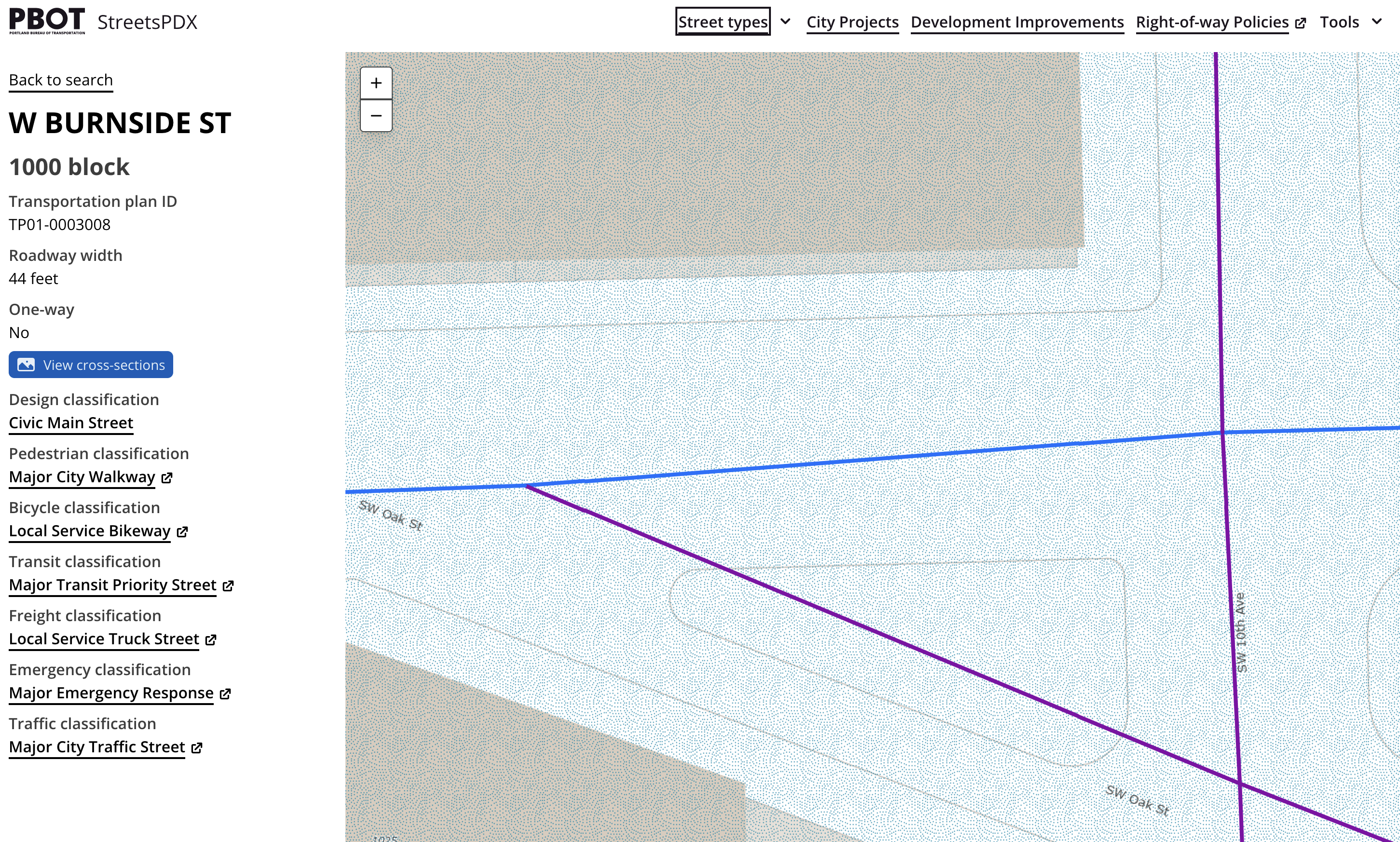
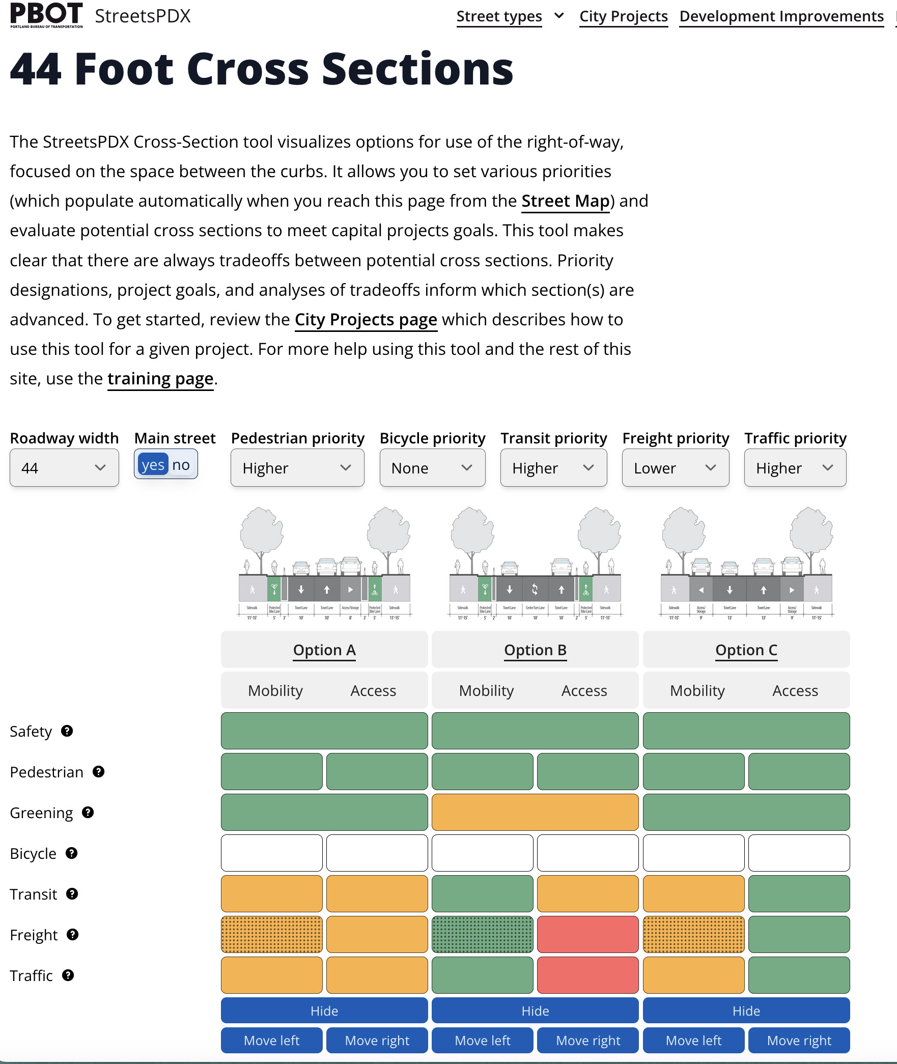
About that map, find your street, see its classification. What are the options for its street cross section? How wide is it? (No longer will I have to throw a tape measure across a street or run one of those wheel things to get a street width, those days are gone.)
As an example, let’s look at West Burnside at 10th Avenue, right outside Powell’s Books (see figure at left). The road is 44 feet wide, its street classifications are listed on the left and you can find suggested street cross sections by clicking the link. On the top menu bar are guidelines for city staff regarding how to proceed through a sea of city code and policy, depending on whether the proposed development is a city or private project (see code guiding private development at right).
PBOT launched the website last July, and in December I listened to Project Manager Mathew Berkow present it to the SWNI (Southwest Neighborhood’s Inc) Transportation Committee. Also attending that meeting was Kurt Kruger who came to “support Matt.”
StreetsPDX can be viewed as a brain dump of everything Kruger needs to take into consideration to do his job. After years of leading PBOT’s Development Review section, he now heads the public infrastructure permitting team that city council created last year as part of government restructuring and regulatory reform.
If you have ever attended a SWNI Transportation Committee meeting, it’s obvious why a city employee might want to come with support. This is where the old lions of southwest transportation advocacy sit, and where the young come to get trained. It’s an experienced group with a very long memory.
The conversation between Kruger and a few committee members following Berkow’s presentation was quite substantive, and deserving of a separate post of it own. So stay tuned for Part II later this week. Until then, poke around with the StreetsPDX map, it’s fun!


Thanks for reading.
BikePortland has served this community with independent community journalism since 2005. We rely on subscriptions from readers like you to survive. Your financial support is vital in keeping this valuable resource alive and well.
Please subscribe today to strengthen and expand our work.
This is very cool to look through! The first policy-type question I have from my first impression is how “pedestrian districts” are determined. I’m stunned, for example, to find the area around the 82nd Ave Transit Center and the intersection of NE 82nd & Sandy are “Pedestrian Districts,” but the space between them in which McDaniel High School lies is not! As a parent with a child who will likely be walking or biking to McDaniel starting next Fall, it just seems like a huge unforced error by the city. It seems that at a minimum the areas immediately surrounding public schools should also be “Pedestrian Districts” given the likelihood to have particularly vulnerable pedestrian traffic. But I’m also not super clear on what kind of development enhancements these Pedestrian Districts provide after just 5 minutes of putzing around on the site.
Michael, I was surprised by similar things, but what is nice is that you can now easily see the designations. It’s a step toward transparency.
Pedestrian Districts, as I’ve always understood, are more of a zoning tool than a pedestrian safety tool. When the City rezones an area, they’ll add a Pedestrian District designation to areas where they want to encourage “pedestrian-oriented” development. Zoning regulations for projects in those districts have different requirements than projects zoned similarly but outside Pedestrian Districts–more requirements for ground-floor windows, more limitations about where parking can be, requirements to build right up to the sidewalk and orient entries to the sidewalk, etc.
If an area isn’t designated as a Pedestrian District, it’s probably because its zoning hasn’t been updated recently, it’s already developed, or for some reason the City doesn’t see a need to guide it towards pedestrian-related development (at least more than the basic code standards already require) etc.–different issues than if it’s an area (like near a school) that especially needs pedestrian safety
They are defined using the “Centers” designations in the Comprehensive Plan, as well as “station areas” within a certain distance of light rail stations. I think the Centers part makes a lot of sense, as those are planned for high density, but I’m not so sure about the station areas. A lot of light rail stations are unfortunately right next to freeways in places that will never really be pedestrian-oriented by their nature.
As with all cities, there are parts of Portland that the city fully controls such as public rights-of-way, city buildings, parks, reservoirs, and so on; a huge portion of private land they can only regulate; large portions of state lands such as freeways, US highways, and to a certain extent public schools; Metro lands (parks mostly); Multnomah County (cemeteries and bridges to the most part); Port of Portland (airport, port facilities); and various federal lands, all of which the city has trouble regulating let alone controlling.
The “Centers” came originally from the Metro 2040 plan and the city added them later – they are designed to combine the land use designation of Pedestrian Districts with PBOT/ODOT roadway classifications. The Pedestrian Districts are land use designations – the city attempting to regulate private property – rather than a transportation-specific designation. The schools, which are separate taxing jurisdictions outside both the city and the county, have separate “Safe Routes 2 School” plans for most of the 9 districts that serve Portland, and the city understandably has a certain legal reluctance to regulate their land uses.
Thank you for the links! I didn’t realize until now that SE Holgate and SE 148th were designed to be linked (same unusually wide right-of-way curving towards each other to some hypothetical I-80 interchange that was cancelled long ago.) It’s fun to see all the pockets of unused right-of-way within the city’s superblocks. Why doesn’t the city have separate colors for private streets and paper streets?
It includes typical (cross) sections! Something that I’ve yammering on about for a while. Again, if you are bike advocate, give up on “glued on” bike infrastructure and change the typical sections for road types to include bike infrastructure from the get-go.
Looking at a “required” 76-foot cross sections, that after over 30 years of owning 122nd, PBOT is still out of compliance of their own standards.
Interesting, the map shows a Community Corridor in my neighborhood going through a farm field where of course there is no road. Who are we to believe PBOT or the what is actually out in the community?
PBOT ought to produce a map of where exactly their streets meet all city standards, so we can go view such streets for ourselves.
Get the GIS team on the horn.
“StreetsPDX can be viewed as a brain dump of everything Kruger needs to take into consideration to do his job. After years of leading PBOT’s Development Review section, he now heads the public infrastructure permitting team that city council created last year as part of government restructuring and regulatory reform.”
In my opinion, this guide is all the stuff Kruger took a dump ON and streamlined things to make it easy for developers, not improve things. Read the background research PBOT did for the related Pedestrian Design Guide, much of which pointed out other cities do much better at enforcing pedestrian infrastructure requirements, and none of which made the final product. https://www.portland.gov/sites/default/files/2020-07/pdg_fg_and_peercity_review_final_062220.pdf
Lisa’s take on the earlier version:
“My understanding is that Streets 2035 will make clear to all parties what the city expects on these narrow neighborhood collectors, rather than having them litigated piecemeal, on the fly, development by development.
But I do think it will be a rip-the-bandaid-off moment when the city accepts accountability for these decisions. I think it is a good thing.
The questions then become 1), how will the city make streets safe for all users on roads too narrow for bicycle and pedestrian facilities? Lower the speed limit? 2) how much car-dependent development will the city continue to allow in neighborhoods lacking active transportation facilities or adequate public transportation?”
https://bikeportland.org/2021/06/07/pbots-streets-2035-initiative-is-under-the-radar-but-could-have-vast-implications-333409
According to these documents (esp Table B-7, page 40 of the pedestrian design guide), many SW streets SHOULD HAVE a “Vertical barrier between pedestrian area and roadway” or a separated parh if speeds ar up to 35 mph, or a painted stripe and shared shoulder if 20 and under. Instead Alternative Review STILL gives SW a paved shoulder at best, at ALL speeds, not even wands. Apparently that is now PBOT policy, in flagrant violation of their own documented policy here.
Lisa has a much higher opinion of Kruger than I do. He is the problem for pedestrians, especially in SW, not the solution. And despite an audit which cast serious concerns over his fitness for office, he is now in charge.