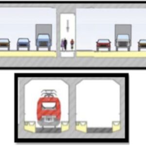
What if, instead of a new bridge over the Columbia River between Portland and Vancouver, we built a tunnel instead? Ever wondered how exactly that would work? At an open house in Vancouver later today (Friday, 12/1) you can see a real-life model of the idea and learn more about it from the guy who’s been pushing the idea for years.
If you’re a regular BikePortland reader, you have probably heard of the “immersed tunnel” concept for the Interstate Bridge project. We profiled the concept in February 2022 and introduced you to its main advocate, a retired engineer and dedicated transportation activist named Bob Ortblad. Ortblad hasn’t just proposed a tunnel instead of a bridge, he’s been an outspoken critic of the current Interstate Bridge Replacement Program (IBRP) design and the staff who’ve repeatedly dismissed the tunnel.
Ortblad believes a tunnel is better than a bridge for myriad reasons; including safety, land use, and environmental impact — but IBRP leaders have dismissed the design. In posts made to social media, they say the tunnel isn’t feasible because it wouldn’t have off/on-ramps, would cost more than a bridge, and would have “significantly more environmental impacts.” Ortblad strongly disagrees and has accused IBRP staff of “manufacturing consent” for a bridge.
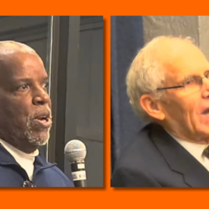
Back in July, a video surfaced of Ortblad getting into a heated exchange with IBRP Program Administrator Greg Johnson during a Hayden Island neighborhood association meeting.
Now, instead of words and illustrations, Ortblad has built a full model that he says disproves the IBRP’s “false assumption” that a tunnel cannot connect to major destinations like Hayden Island, downtown Vancouver, and SR-14.
Here’s the text from a flyer for today’s event:
The Oregon and Washington State Highway Departments (the DOTs) falsely concluded that the tunnel option evaluated during the initial screening of alternatives for the IBR project could not provide connections between I-5, local Downtown Vancouver streets, and SR-14. That led to the rejection of the tunnel alternative in favor of the current proposal – a giant 200-foot wide mega bridge, towering 100 feet above Vancouver’s historic waterfront.
The DOTs continue to lie to the public about the feasibility of the tunnel connections.
The Tunnel Model That Exposes the False Assumption To illuminate reality, a model of the Vancouver tunnel interchanges was constructed. The model makes it clear — the tunnel alternative offers superior connectivity to the mega-bridge option currently under design.
If you’re intrigued by the tunnel concept and want to ask Ortblad about it in person, there’s an open house in Vancouver today from 11:30 am to 2:30 pm in the lobby of Lucky Lager Warehouse (215 W 4th St.).


Thanks for reading.
BikePortland has served this community with independent community journalism since 2005. We rely on subscriptions from readers like you to survive. Your financial support is vital in keeping this valuable resource alive and well.
Please subscribe today to strengthen and expand our work.
I have to wonder how to-scale that model is supposed to be, because if it is as Ortblad depicts it, I have significant concerns about the continued navigability of the Columbia.
It just shows the very north end, which is the key area of dispute. The tunnel would continue to descend south, providing sufficient draft clearance in the channel.
I’m assuming it is not to scale depth-wise. The channel is where the existing bridge lift is, and I believe the tunnel was to be 40 feet below the river bottom at that point.
The biggest issue is that there is a development planned on the river bank where they are proposing the tunnel will be built. Construction is to start in 2024. I would think this would change the construction method and depth required on the north bank of the river. See the link below.
https://djcoregon.com/news/2023/07/10/mixed-use-project-on-track-along-vancouver-riverfront/
Thanks for sharing the information. I missed the presentation but was able to take a look at the model just as they were shutting down.
Take 20 minutes to familiarize yourself with the Columbia River marine map here;
It’s shallow and dredging the Columbia River is a significant undertaken by the Army Corps of Engineers to keep the entire river navigable. The lowest highway tunnel is like a bazzillion times deeper than the Columba River and includes some solutions for the grade differential issies.
A tunnel is totally doable and reduces the number of piers going into the water to muck up marine shipping traffic. Instead of replacing the existing bridge. we just add a tunnel completely under Hayden Island. Drop the tunnel
Hayden Island residents keeps existing access points. Keep the existing i-5 Bridge [this is not a good ped/walk solution unless we take a lane from the old bridge, which we can have the conversation later]. Drop the tunnel at the Expo Center interchange.
At this point I can’t see any other way unless we take out Fort Vancouver, which I’m totally down with. There were a few indigenous massacres there, so no hard feelings paving that BS over.
I mean if we are going to have a big dig might as well make it BIGGIE BIG Dig TUNNEL.
Someone please go and give a report-out!
I just got done listening to the GBH news podcast about The Big Dig in Boston. I can’t help but feel like the interstate bridge + rose quarter is turning into our own version of the Big Dig. A painful and expensive boondoggle to speed up the commutes of car-driving suburbanites, with little to no investment in public transportation.
It will enable the extension of Max to Vancouver; that’s something.
That was a great series!
The Columbia crossing/IBR definitely has a big dig feel to it. That project was always only going to be successful if there was a simultaneous massive investment in public transit. The car project got built, but they forgot about the transit along the way (I also felt like the podcast could have done a better job talking about failed opportunities to improve transit earlier on. First mention wasn’t until episode eight, or something). Feels like Portland will end up in the same situation. Extending the yellow line across the river is a token transit investment that won’t move the needle on regional per Capita vmt.
It is more than “feel”. The lead consultant for the Big Dig was a firm called Parson’s Brinkerhoff. After they were fined, along with their partner consultant, over $400 million for fraud, their 12,000 person staff was bought for over $1 billion by the lead consultant on the IBR. The Big Dig consultants are the same cast of characters doing most of the work on the IBR. What you “feel” is fraud.
Yes, it was fascinating to learn about how opaque Bechtel-Parsons Brinkerhoff was during the entire process, and how the city/state eventually got put in a positions where they’d either have to keep BPB at the general contractor and finish the project, or fire them and end up with a bunch of half-finished tunnels.
If you come across an “honest” megaproject contractor, do let us know. I have no doubt that Bechtel is as corrupt as it needs to be, as is the City of Boston, but Bechtel is also famous for building the Hoover Dam, the Channel Tunnel, much of the DC subway, BART, the second (2002-7) Tacoma Narrows Bridge, numerous nuclear, LNG and hydro power stations, WW2 Liberty Ships, and the lid that covers the failed Chernobyl nuclear power station, as well as whole cities in the Middle East – quite likely with lots of bribes and payoffs. Reagan appointees Casper Weinberger (Defense) & George Shultz (State) were former executives there.
Any I-5 tunnel under the Columbia River ideas are unquestionably preposterous. The I-5 gradient north of the river rises sharply. An elevated I-5 bridge replacement (above the railway) reduces and smooths this gradient as it leads to the new bridge. The higher above the waterfront the new I-5 bridge towers the better. We should not forget Mt Hood and downriver views with some new CRC bridge. That said, the IBRP project as proposed is just another boondoggle our state DOTs have in mind while planet Earth burns to a crisp as global warming predicts. Lynn Peterson should be remove from office as the singularly irresponsible politician who let the planning process 2004-2013 go to hell and no agency leader was held responsible for the waste of time, effort and millions in planning new I-5 bridge designs recognized as a boondoggle. Electing Obama in 2008 and Senator McConnell’s oath to not cooperate signaled both state DOT agencies to take as consent to propose a bridge (double-deck) that could NOT be built. Fat truckers agreed saying “We don’t need no stinkin’ murgency access corridor.”
One aspect of the Big Dig is already the same as the interstate bridge project. The lead consultants on the Big Dig were fined over $400 million for fraud. They have not been fined yet, and may not be, but the lead consultants for the interstate bridge replacement have already committed fraud. I see no reason they will stop now. The question is – will they get caught?
I trace the fraud back to 2008, the election of Obama and republican senator McConnell’s oath to not cooperate. Bridge designs before 2008 were single-deck. Bridge designs after were double-deck, at least 5 double-deck designs peer reviewed and rejected as “structurally unsound.”
Single-deck transit/ped/bike spans offer an emergency access corridor.
“We don’t need no stinkin’ murgency access coredoor.”
Oregon government has avoided investing in road development for 40+ years. Drive north and south on I-5 between the Fremont bridge and Vancouver, you will see numerous opportunities to widen roads, which haven’t been developed for decades. I think government is trying to force people to accept governments’ biased ideas for infrastructure, by ‘starving’ the public of necessary changes unless the public approves the WHOLE boondoggle.
Fremont bridge to Hayden Island is near its capacity number of lanes. The supportable IBRP bridge design is 4-lanes southbound, 5-lanes northbound (rush hour), 3-lane transit/ped span (single-deck).
ODOT, WsDOT, PBOT, Metro & Tri-Met have screwed up.
The term boondoggle is putting it lightly. The Big Dig and I-5 “widening” projects differ almost entirely. Rose Quarter and Columbia River I-5 projects are fiasco, debacle and atrocity. Both worsen existing traffic hazards inherent in their design. The idea to relocate I-5 Southbound exit from Broadway to Clackamas is a guaranteed severely high accident rating. Unacceptable. Relocating the southbound on-ramp, the one improvement most needed, is suddenly
OFF THE TABLE ?? Oh, and the Green Loop bikeway is put on a Broadway/Weidler couplet. WHAT!! ODOT boy Kris Strickler
and other DOT agency leaders SHOULD be removed from office.
The ramps in controversy at the Rose Quarter should really just be removed. No need to build a thousand auxiliary lanes, no more worries about safety, less expensive.
But it’s ODOT we’re talking about, so we couldn’t possibly decrease the level of service.
“Relocating the I-5 southbound on-ramp, an improvement most needed is suddenly off the table.” The current on-ramp 2 blocks south of Weidler is at freeway level and motorists must crane their necks to look behind at approaching traffic and accelerate hard to get up to speed in the short distance where they must merge left to get on I-5 and where traffic on I-5 must merge right to access I-84. Both north and south on-ramps have this inherent traffic hazard in their design. Adding lanes increases speed which reduces time necessary for these merges.
Relocating the southbound on-ramp to the Weidler bridgehead offers major safety improvements. The new ramp is downhill to get up to speed more readily and with better visibility to more safely conduct the merge (a “cross-merge” – ie, merging both right-to-left and left-to-right lanes). Another major improvement is how traffic from Broadway goes directly to the new southbound on-ramp at Weidler instead of continuing west to Vancouver Ave, south through Weidler to Wheeler, a classic bottleneck that ODOT evidently doesn’t care to explain why this major improvement is off the table. It may be that truckers from Albina Yards who use it want it to stay. I don’t doubt truckers could get on Weidler to the new on-ramp just as well.
My alarm bells are going off regarding this project and too many others as proposed. Criminal conduct is plainly evident. ODOT does NOT care about public safety; just the opposite. ODOT director Kris Strickler and other agency leaders are committing criminal violations of the planning process that put the public in harm’s way. The ped/bike bridge over I-5 at Clackamas Street is also off the table. The Green Loop route is redirected to the Broadway/Weidler couplet that cyclists will avoid because of the extremely hazardous traffic. Racist ODOT leaders think themselves servants to Portland’s cruel ruling class.
Ortblad deserves an award!
I thought Greg Johnson’s contentious dismissal of Ortblad was really shocking, and speaks volumes about how bad ODOT are at their jobs.
They usually are when the local construction companies they’re friends/partnered with won’t get a contract. Two of the biggest are in SW WA and they ALWAYS seem to get these….
Anyone else ever play Cities Skylines? Or some other urban modeling game/software? Perhaps someone could rebuild the same model digitally and spread it around the internet.. Perhaps they could do the same for the bridge and show everyone how monstrously huge it will be!
For those cycling to see this model … there is a double staple rack out from on 4th Street at Columbia…located a short hop from the Interstate Bridge and the Bi-State Columbia Bike Highway. Its in the foyer of the building shared with other businesses.
Haha, a 90 degree turn exiting a tunnel is proof of concept? Cool craft project though.
Love Bob’s passion and dedication.
Lol the last time we were gonna build the bridge it would have been a major improvement with bikes and pedestrians sharing their own entire deck with MAX trains. Bike Portland totally shit the bed on that one in what looked a lot like a quid pro quo with ultra right wing Christian nationalists from Camas that are scared about growth in west Vancouver. Looks like they’re hitting the repeat button. I wonder how big the bribe is this time.
Glad there are finally some out of the box proposals like a tunnel.
Europe and east coast cities have been successfully doing below water tunnels for years. This is not rocket science.
We can continue to discuss replacement of the bridge for another 20 years with no progress or we can start moving this forward.
This tunnel (pipe dream) is physically not possible nor advisable if it were because its safety hazard accident rating is off the charts. The bridge design Bill refers to was an idiotic double-deck design, MAX light rail and ped/bikeway on the lower deck. One problem among many was that a single-deck design (2004-2008) would’ve located this 3-lane transit/ped/bikeway span on the same level to form an emergency access corridor. “We don’t need no stinkin’ murgency access corridor” truckers griped.
I am ok with a bridge or tunnel or flying cars or boats however you want to move pepole great. The issue with a tunnel is DOT will not allow hazardous materials to travel in a tunnel. Which means trucks and that comes out to millions of dollars in freight per day that freight will get over the river so a bridge will be there as always and I am not endorsing corporate greed but money will get what it wants and freight will move with or with out a tunnel so work that out but I whould bet on a new bridge I do not think both will be.funded.
Uhh, they can go over the river using 205. They should already be anyway, as hazardous materials shipments should be avoiding densely populated areas. Not saying the land near 205 isn’t populated, but definitely less so than I5.
The tiny % of trips with hazardous materials can take the I-205 bridge.
One of the virtues of an I-5 tunnel for through traffic is the opportunity to de-commission the existing I-5 freeway between portals, replacing it with an arterial roadway across the existing historic bridges. Huge amounts of riverside land becomes available for building/expanding riverside communities on both sides of the River. The existing bridges can be refashioned with bike/ped facilities and light rail.
Can you imagine how great it would be to walk or ride across the existing bridge WITHOUT car noise? In my opinion, the car-free trip cross the Columbia would the best “promenade” in the Northwest.
I’m a truck driver and traverse the interstate bridge daily. As it is currently, my 93,000 pound loaded semi truck loses momentum on the climb up the hill north of the bridge – a struggle that is only bound to worsen with an immersed tunnel.
I’m certain the bridge design will feature a less significant incline between Janzen Beach and the shipping channel, perhaps similar to that of the Glen Jackson Bridge (which has an almost-flat northern approach between the channel and the rest of Vancouver.
From what I have read, the tunnel and the proposed bridge would have the same grade, 4%, except that the bridge would be susceptible to ice and the tunnel would be safer, especially large trucks.
Current bridge proposal would have a steeper grade than the Glenn Jackson iirc
You are correct about the grades. For BP readers it is important to note that the vertical distance up to the high point of the bridge is over a 100′ more for the bridge.
The grades can be the same and thus there is no reason the tunnel climb would be worse. In fact, the length of the grades are going to be a lot greater for the bridge because it is higher than the tunnel would be deep.
Let’s make it happen. It solves rising river levels in response to rising sea levels . The down slope is not as steep as the up slope on the bridge, saving lots of energy. It is likely more stable in an earthquake i.e. Loma Prieta in the S.F. Bay area in 1989. A tunnel is way more visually appealing the to natural beauty of the Columbia River. Makes a safer crossing as all traffic is out of the weather.
4 words …. Hampton Roads Bridge Tunnel
https://www.gearthblog.com/blog/archives/2012/10/hampton_roads_bridge_tunnel.html
Hampton Roads tunnel is not a fair comparison tunnel example. The two tunnels have little in common. Traffic in tunnels should remain in the same lane their entire length. The idiotic I-5 tunnel under the Columbia River idea requires lane changes. Its 5-lanes northbound and 4-lanes southbound have on/off ramps that require too many lane changes at high speeds. Boom! Tunnel idea shot down!
In 1997, work done on the I-5 bridge that was expected to take six weeks instead took six days because everyone heeded the advice given by the government and media, which was to carpool, take mass transit, work off-hours, work from home, bike, use company-provided shuttle vans. The traffic on I-5 that week was non existent — rush hours were like a Sunday night at 11 PM. It was incredible and showed what is possible if people change how they commute. Of course, the next week after the government announced the bridge work was finished it went right back to being the usual rush hour hell. The same thing happened a few years ago. With smartphones and apps, the vast majority of weekday commuters could be carpooling to/from work everyday. Imagine how much better everything would be if people did what they did in 1997. So much money and time saved for all, cleaner air, less pollution, longer lasting personal vehicles. But human nature gets in the way of that.
In 1997, Columbia River I-5 Bridge replacement proposals were in only early formulation stage. They included some idea for MAX light rail but I no longer support rail on the ped/transit corridor. An extension of the Vancouver BRT bus line to a Hayden Island junction with MAX extended from Expo Center is safer. The 3-lane transit/ped span on the most logical “single-deck” bridge design creates an emergency access corridor. In a major accident, light rail trains would stop but buses could steer around stopped emergency vehicles.