The 40 Mile Loop is having a moment.
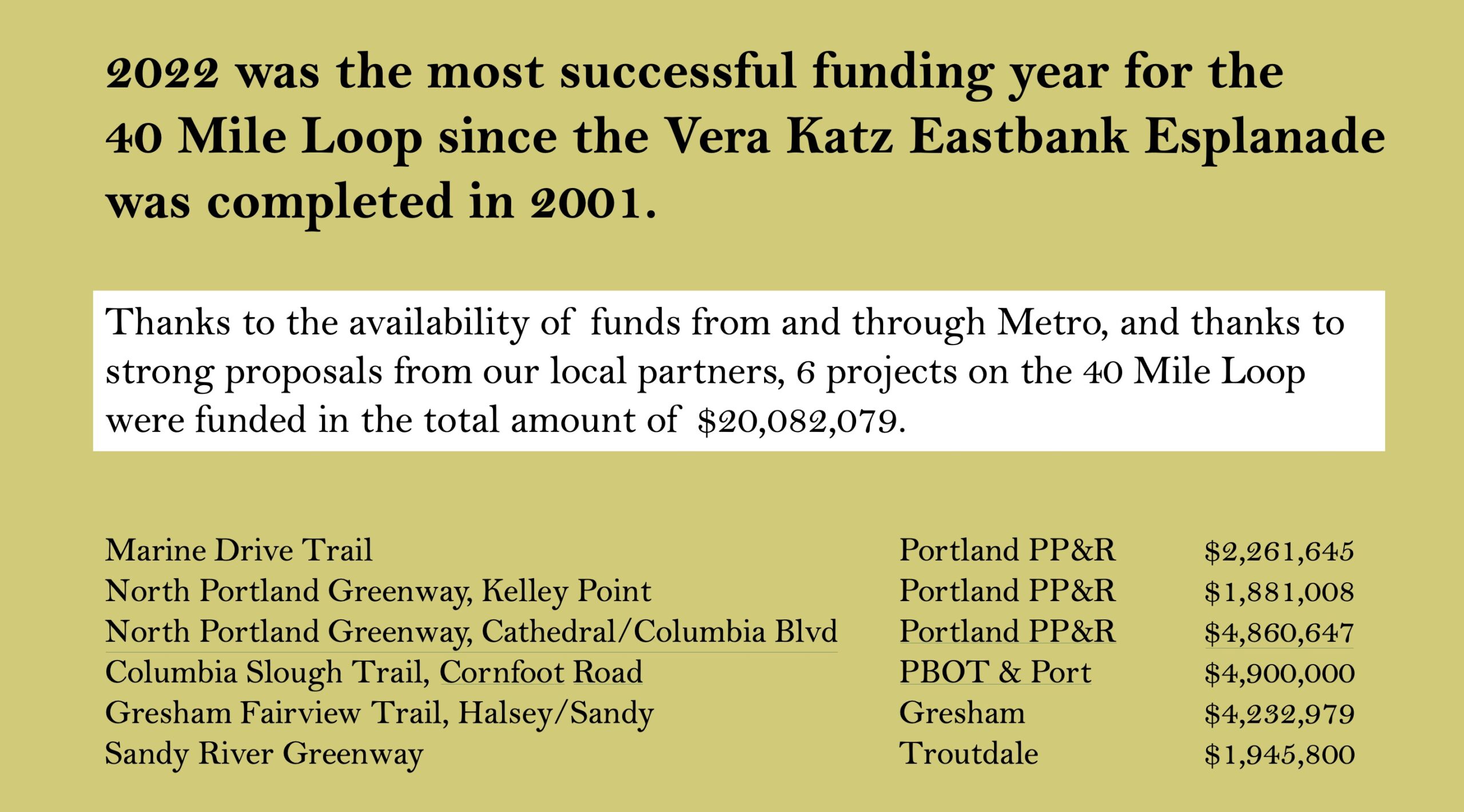
The 150-plus mile network* of off-street paths that marks its origin to 1983 — and the similarly named nonprofit group behind it — is coming off its most successful funding year in over two decades and was just recognized by Portland City Council with high praise and an official proclamation to mark its 40th birthday.
Why? Well there’s something to be said for anything that remains vibrant after 40 years. Then there’s the positive feedback loop where each piece of new path makes the network more valuable, which makes it easier to get new pieces of path funded, and so on.
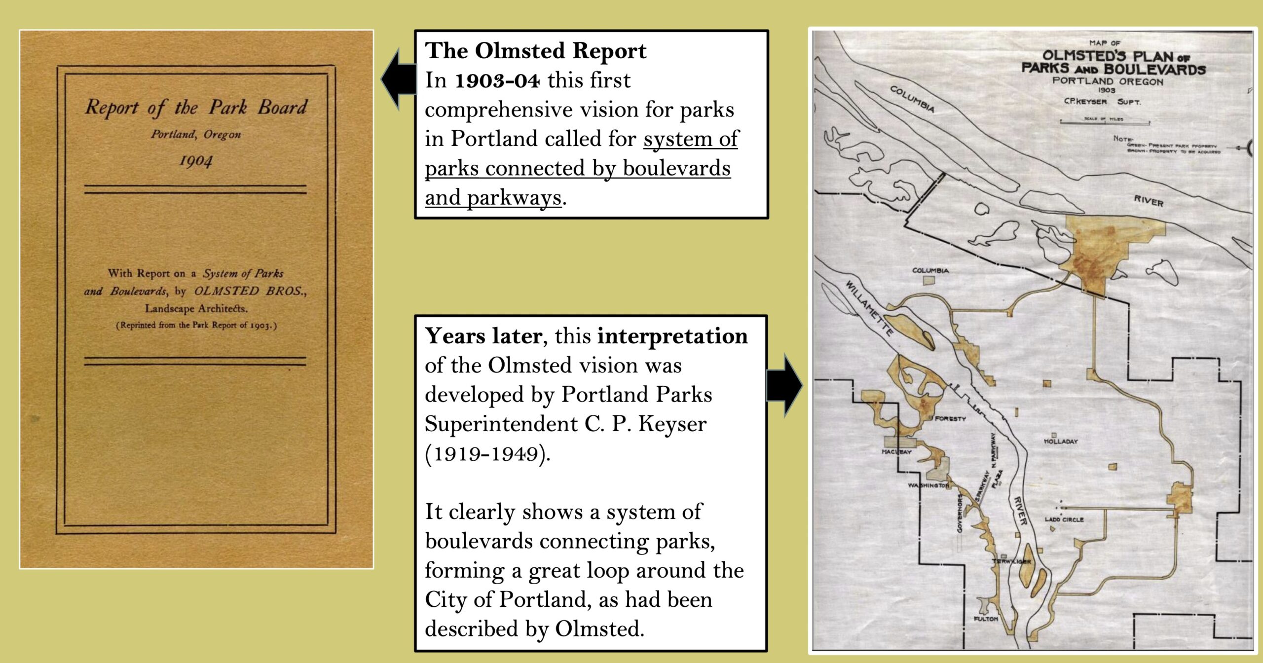
It helps too that the seed for the idea is 120 years old and came from the Olmsted brothers who envisioned an interconnected system of paths and trails around Portland that would keep everyday folks in close proximity to parks and nature. (The effort to build it began in earnest during the gasoline shortages of the 1970s when planners wanted to give folks a way to get around without a car.)
Another factor in this success are volunteers with the 40 Mile Loop Land Trust. One of them, retired Portland Parks planner Jim Sjulin, has done yeoman’s work to (quite literally) put the path network on the map.


Two years ago we shared Sjulin’s 40 Mile Loop gap map. Now he’s really outdone himself. He’s expanded that effort to encompass every bike trail and path in the region. It includes what’s completed, where the gaps remains, and any other information Sjulin knows about the segment. In short, he’s created an invaluable resource for trail planners, advocates, riders, and dreamers.
When he shared this map with me recently and I replied with “Wow!!” he admitted that he got carried away. Here’s more from Sjulin:
“The map now aims to include all regionally significant trails and their status. And it also includes what many call ‘Community Paths’ which are really important connectors in neighborhoods. Nothing below 8 feet in width however. For significant parks I added site trails. See Forest Park, Mt Tabor, Washington Park, Powell Butte, Tualatin Hills Nature Park. Perhaps the most exciting parts are the exurban routes. Salmonberry, Chelatchie, Columbia Gorge, and the beginnings of a Willamette Greenway Trail on the eastside and on the westside.”
Sjulin has had major help collecting the information from other volunteers and the group’s partners partners including: Portland Parks & Recreation, Tualatin Hills Parks and Recreation District, City of Tigard, SW Trails, Metro and other 40-Mile Loop Land Trust board members.
Asked what he hopes the map achieves, Sjulin said, “Nothing would please me more than for trail planners to use this to see the bigger picture and to help them ‘make the case’ for their project. Equally importantly, I’d like more of the general public to understand what a fabulous system of off-street trails this region is working to put together.”
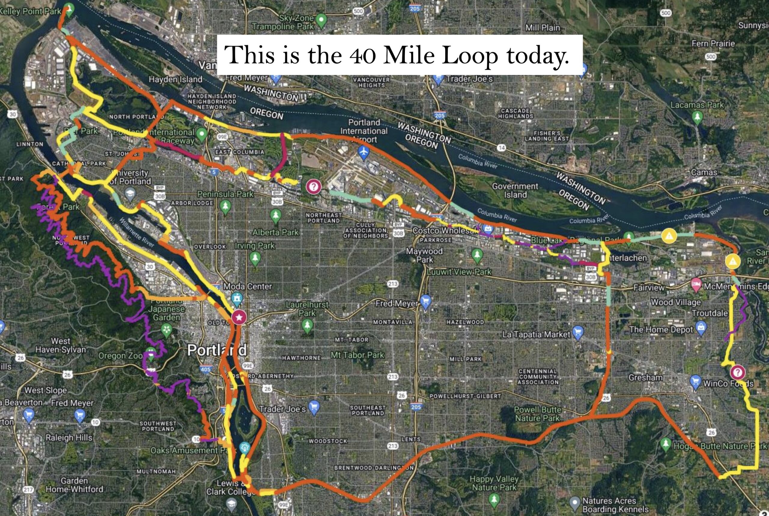
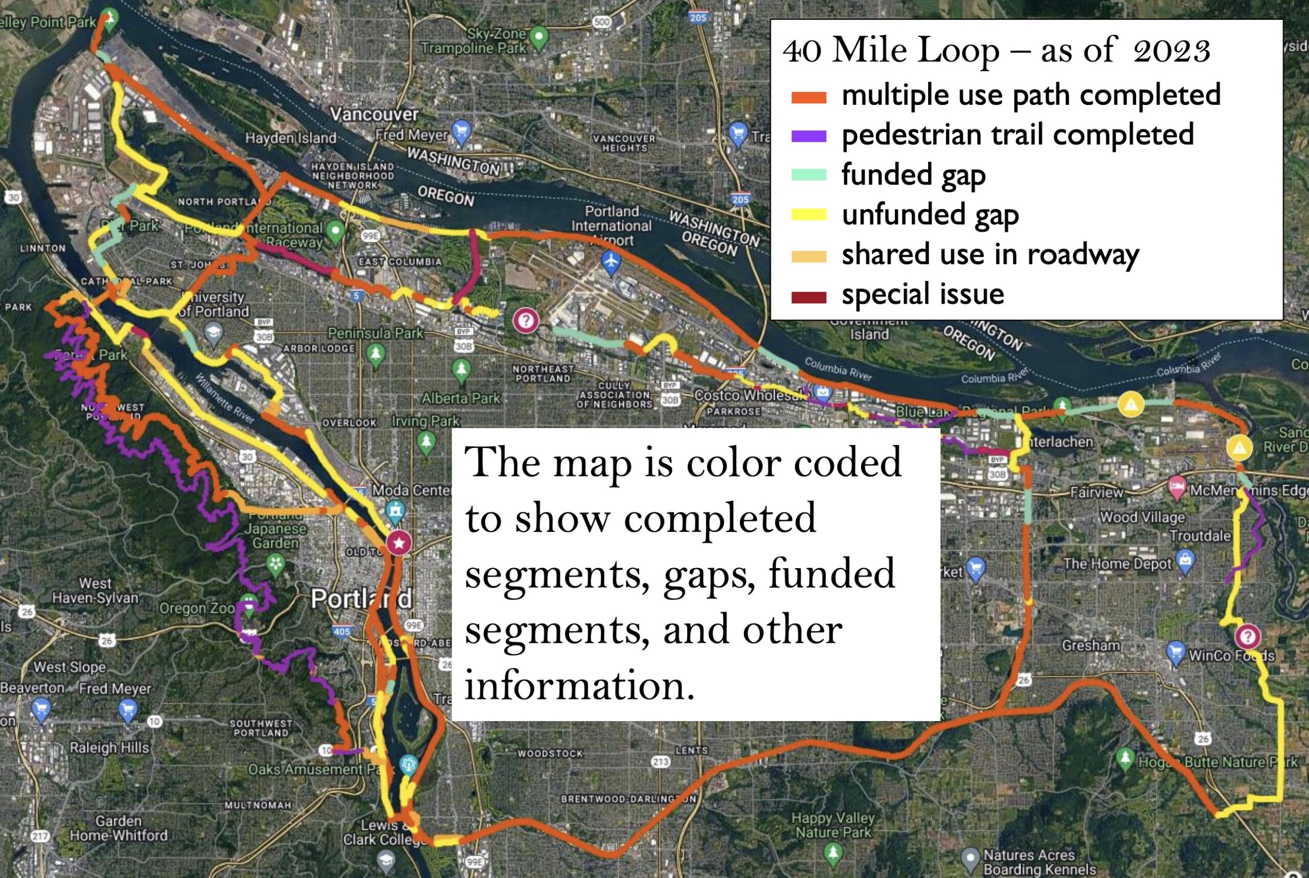
And with each gap filled, the vision of a continuous path around the region comes into clearer focus. Sjulin says once the currently funded gaps are complete, the network will be 73.5% complete.
The biggest challenge? Safety and perception of danger on the trails from people who live in adjacent encampments. At a presentation by Sjulin and other board members at Portland City Council on June 14th, Commissioner Rene Gonzalez said he loves the 40 Mile Loop but he also said parts of it have become, “dangerously unsafe in recent years.” “There are parts of the loop that I simply don’t want my children on in certain parts of the day,” he said.
But Sjulin told Gonzalez, Mayor Ted Wheeler and the rest of the commissioners at a City Council that, thanks to more attention and investment on the issue of late, “I think we’re turning the corner on this issue.”
Hopefully, new resources like this map will impress upon elected officials and policymakers that these paths are worth fighting for. As the climate crisis rages on and the popularity of cycling continues to grow, we should approach the completion of this network with the same zeal as our interstate freeway system. We’re so close to completing the network, we shouldn’t slow down now.
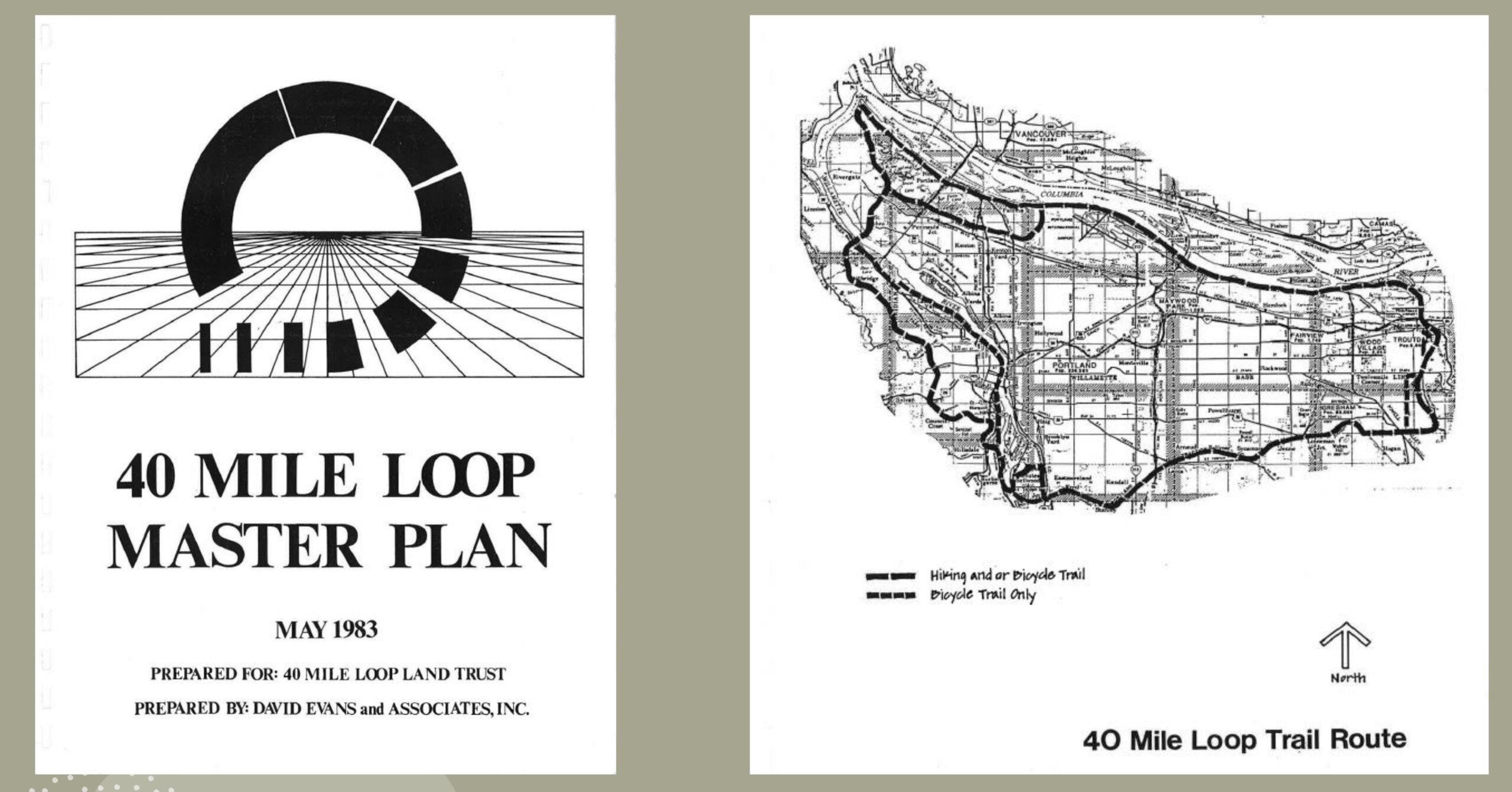
*The name “40 Mile Loop” is an arbitrary one. It came about when the original Olmsted plan maps re-emerged and a planner measured the original vision of connected trails with an opisometer — a tool used to measure curved lines. The result was about 40 miles. The name was set in stone when the 40 Mile Loop Master Plan was published in 1983. Learn more at 40MileLoop.org.


Thanks for reading.
BikePortland has served this community with independent community journalism since 2005. We rely on subscriptions from readers like you to survive. Your financial support is vital in keeping this valuable resource alive and well.
Please subscribe today to strengthen and expand our work.
Concerning the northern segments of the Oregon Electric rail trail. The state owns the right of way between Banks and the junction with the BNSF bridge over the Willamette (as well as the entire line out to Astoria), but Portland & Western operates freight service. As far as I can tell, the segments indicated as the trail are still active freight lines (or at least P&W still indicates them as such on their website). Depending on how wide the right of way is, it may be possible to create the trail without interrupting rail service, though considering these particular segments were not ever particularly important, I’d assume it’s not wide enough for both rail and trail.
Maybe someone who is more familiar with the status of rail operations in Oregon can weigh in, but it seems a bit strange to me to have people planning rail trails on rail segments that are still actively used for railroading
From what I’ve seen of this route, it doesn’t seem like a trail could be added adjacent to the existing freight lines. The corridor navigates significantly hilly terrain and there are multiple tunnels and steep cuts/fill sections. I guess they want to document it as a potential future corridor, but it would obviously need to be abandoned first.
Very exciting to read this.
1) I can attest to the washed out/caved in section in the center of the Salmonberry. Oowee that’s going to be rough to fix. There’s an undeveloped road that adds a LOT of elevation, but bypasses this section.
2) Blumdrew you took some of the words out of my mouth. I’ve been wanting this to exist for a very long time. GP has a mill in Wauna, but the rest of the PNWR ROW is completely abandoned to Astoria. Imagine riding a separated path from Astoria to Wauna along the Columbia. The bridges are all rusted around the Knappa area so that would take some work. As for the rest, rail with trail does exist successfully in quite a few places (e.g., a very successful section in Morristown, NJ), but is politically difficult.
3) The Cazadero Trail: “Deep Creek Gap” is, technically, walkable-as long as you’re ok getting your feet wet-during the Summer. Any updates from people would be appreciated as completing this gap would get a continuous trail all the way to Wildcat Mtn Drive. Not sure about the structural integrity of the trestle over Eagle Creek, but otherwise there’s plenty of ROW along 224 to continue that path all the way to Estacada/N fk res.
4) Since we are dreaming big, why not include the abandoned road on the East side of Yale Lake for the Chelatchie RT?
I would much prefer the railway to Astoria to have rail service rather than being a recreational trail. Having better non car options to the coast would be really nice, and the Portland – Astoria route would probably be the most realistic and highest ridership potential. I’d ride it anyways.
I’d much prefer some sort of off road trail from Vernonia to Astoria for riding NW from Portland. The CZ and Banks Vernonia already exist and are quite nice to ride.
I’ve bushwacked the deep creek/Cazadero trail bit. It’s doable, but a sketchy. I imagine it would be pretty cheap to build a better trail, considering most (if not all) of the land is owned by the county
Well yeah in my perfect world Astoria-Portland would be rail and trail, but there’s virtually no chance that’ll happen. The entire section of rail from Wauna to Astoria would have to be rebuilt including the dozen or so bridges. Again I’m not saying it shouldn’t be done, just that Oregon is looking to spend 7-8 billionish for a new freeway and so our priorities are elsewhere. Also, building a trail might increase interest in a train in the future, or even rides from Longview? The way the Salmonberry is progressing would be a good model. Work from each end and do what you can with the meagre funds you have.
I have been on many unofficial off-road routes from Portland to Astoria. Unfortunately, it’s virtually impossible to avoid going through logging land. An “official” route would be cool though.
I’m very much in favor of seeing this finished, particularly the Marine Drive segment. There’s just one big gap remaining there. We’re also SO close to completing the Springwater Trail and the riverfront trails on both sides of the Willamette.
As far the proposed North Portland greenway trail, I think PBOT should look at a less-pretty but workable alternative to the Swan Island/Albina Yard segment. First, connect University of Portland to the Greeley bikeway with a multi-use path or protected two-way bikeway along the west side of Willamette Boulevard. Second, connect the Greeley bikeway to Kerby & Russell with a new multi-use path on ODOT and City of Portland property; the trick will be working out a safe bike/pedestrian route that doesn’t interfere with city vehicle fleet operations. Since Tubman Middle School will probably be moving, it would be fairly easy to run a bikeway from Commercial & Russell to Broadway & Flint, and then work out the best way to cross Broadway/Weidler and the Rose Quarter to connect to Lloyd Boulevard.
That would create a route that’s almost entirely multi-use path and/or protected bikeway and doesn’t need to wait on a deal with Union Pacific. We could have it just as soon as PBOT is able to fund it.
If our priority were to address ongoing ecocide, these recreation-oriented trails would be low priority transportation projects. Protected and enhanced bike lanes on Portland’s most trafficked streets would, on the other, hand be very high priority.
I think that’s certainly true for some of them but a lot of these “recreational” trails also represent medium to long distance intercity and intracity connectors that are crucially car-free. Bike lanes are fantastic for the last mile or two of a journey but if I’m going where I live to Gresham for instance I would much rather ride the “recreational” Springwater path over taking a long journey on a high traffic road in a bike lane with cars a few feet away and constant points of conflict with intersections, driveways, etc.
Then can we start planning trails as if they are regional connectors? The only ones that are effecient to ride on are rail-to-trail conversions and the ones that follow highways. So many trails are designed with recreation in mind that are circuitous, hillier, and longer than the roads theses trails follow. I’m talking about Fanno creek, the planned red electric trail, Willamette greenway, etc…
I would love for the trails to be planned as actual regional connectors! I have never been involved in the planning of any trail so I’m not the one advocating for more recreational trails. However, if the recreational trails are what we’re getting and they’re serving as makeshift regional connectors then I want to encourage their creation rather than throwing the baby out with the bath water just because they are being designed as recreational paths first.
Recreation is important. And there is no reason a trail can’t serve both recreation and regional connections. The issue I see with planning trails is that they can go only where there is significant amount of linear right of way. That is where the urge to want safe bike infra on bigger streets comes from because there is ample amount of ROW and they go where people need to go.
You both have good points. If we’re purely playing the numbers game, and want to get as many people on bikes as quickly as possible, Pierre’s right: completing the current highly trafficked streets with a separated network is key. And TBH a lot of those streets would be in closer in.
On the other hand a lot of these trails have differing funding sources (e.g. metro, Clackamas co, ODOT) so it’s not an either/or. I just happened to live near the Springwater when I was a kid, so I was lucky enough to tear up Powell Butte. There is zero chance I would have had that opportunity without the trail. I want other kids to have similar opportunities. Aaron I also think calling paths “recreational” is misleading. I do think we need a Big Idea like the Great American Rail Trail in order to market this. A lot of people pointed out the GART (really slides off the tongue) to me only after it got national news. How about the Trans Oregon Trail? Salmonberry/Cazadero? The Timber Trail and PCT are known across the country. Let’s sell this idea.
No parent in their right mind would let the 12 year old ride alone on the Springwater. The Wonder Years days don’t exist in Portland…
Be that as it may in its current state, that isn’t an inherent property of these car free connector paths and it’s not a reason to give up on building a car free trail network. The lack of safety (or perception of lack of safety) is the result of a policy decision by the city and could be changed completely with a policy change, requiring zero physical changes to the path.
Remember, the current state is going on 15 years now.
I like the “special issue” designation on the map. Spot-on for a few areas.
“205: Burnside to Stark
Not recommended for travel. Dangerous section due to trail being sandwiched between sound wall and fence. Utterly creepy. Needs to be redesigned and rebuilt to improve user safety.”
Another interesting one:
“There are 2 parcels making up this gap and both are owned by the City of Portland. The Police Bureau’s training facility was built and occupied without meeting the requirement to construct the Columbia Slough Trail. This is a violation of of City Code.”
then, literally connected to the east side of the above section:
“This segment is paved (asphalt) and is 12 feet wide.”
Unfortunately this is an increasingly uphill battle as the public loses patience with ill-advised policies concerning drug use and illegal camping. A decade ago I would have chuckled about Carlton, of all places, worrying about having to deal with trash and tents on a shared use trail, but the problem’s spiraled so far out of control in Oregon now that the concern is hardly unrealistic. I’ve seen the problem rear its head along Banks-Vernonia and even the Crown Zellerbach lately, never thought that was possible. And it’s absolutely heartbreaking to come across a debris field of trash and disassembled vehicles in what was a premier rail trail experience just a few years ago.
Many here won’t want to hear it, but we did this to ourselves with Measure 110. If voters overturn it– as I expect they will in the next few years– that will be a leap forward for the outlook of the 40 Mile Loop and beyond.
In addition to that, it’s likely only a matter of time before a challenge to Martin vs. Boise makes its way to the U.S. Supreme Court. I’ve got high hopes for that opinion.
Isn’t it terrible the state we’re in, we can’t have an honest conversation about MUPs without also addressing drug use, illegal camping, and criminal activity. I’m at the point now where the only path I ride with my kiddos is in Sun River.
I am here and I agree with you about Measure 110: it will be overturned soon.
Yep but Bike Portland, local transportation nonprofits and the bike activists in Portland Metro don’t want to address this elephant in the room as it “lacks compassion”. This attitude is dooming active transportation in Portland
Hi. For the record, BikePortland has addressed this issue multiple times… So much so that many people who I would assume are far to your left politically-speaking have expressed the same type of sentiment you are expressing (several have even cancelled their subscriptions because I am “anti-homeless”!. So how is it possible that I’m both ignoring this issue and talking about it too much? Hmmm. Maybe it’s because people on both sides of the political spectrum would rather scapegoat and tear down BikePortland in order to further their own agenda and do performative outrage than actually work on fixing the problem.
Martin v Boise ruled that that anti-camping ordinances are unenforceable if the city has insufficient shelter space. What, in your opinion, should a homeless person do in that situation, if the ruling were struck down?
The shelters in Portland are rarely full so there is that….
If the ruling were struck down maybe people who are refusing shelter now and are given no option would try one, and yes, we should build more.
However, any homeless survey in Portland show that people relocated here for various reasons and the citizens of Portland should not be responsible for housing the entire nations problems.
If anyone travels anywhere right now and I travel a lot, Portland is an anomaly right now with how just plain crappy it has become and how little we do about it.
Do you have a solution for that?
But the shelter capacity is still not enough to house all of Portland’s homeless capacity. So even if we assumed every single person would decided to use a shelter because they didn’t want to face penalties recriminalized, the shelters would not have enough space. So I’ll repeat my question: what should a homeless person do in a situation where camping is illegal but there aren’t enough beds? What’s the legal option for them?
(If your answer is, “we shouldn’t recriminalize it until we have enough beds” then Martin v Boise doesn’t apply anyway)
To your second question, no I don’t a complete solution (besides the need to bring down housing costs); it’s a complicated issue with a lot contributing factors. But your comment implies you think the state should punish people for sleeping on the streets even if they have no alternative, and I don’t see that as a solution to anything.
Get help or get out. I have compassion fatigue if you can’t tell.
And if you are unable to get into stable housing or a shelter? You just have no choice but to break the law?
It’s a common misconception that addiction – and by extension drug decriminalization such as Measure 110 – is the main cause of homelessness. But correlation is not causation. Just because people are visibly homeless and on drugs doesn’t mean the latter caused the former to happen.
Researchers at the University of Washington studied the 30 biggest US metros and found that local housing markets are the main factor in whether people are housed or unhoused. For instance, Multnomah County has among the lowest rental vacancy rates and highest rents, and consequently the fourth-highest rate of people experiencing homelessness:
https://www.kgw.com/amp/article/news/local/homeless/new-study-housing-market-root-cause-homelessness/283-819457a7-9606-42c6-9cb3-62bd25661d2b
“I don’t really see the escalation in rent having anything to do with — I mean, very little to do with homelessness … if your life has put you in a position where you cannot afford basic sustenance including housing and food, it isn’t because the local rents have been raised. I think there’s a bigger calamity happening.”
Amazing that you missed this part of the article you cited.
News outlets usually try to get perspectives from “both sides” of a given issue. That doesn’t make both sides equally valid. Personally I’m more inclined to believe actual researchers than a lobbyist for landlords, but that’s just me.
“correlation is not causation”
rebuts by citing correlation as causation..
When a correlation holds true across multiple cities and counties separated in both time and space, you need a better explanation than sheer coincidence.
So, more correlation as causation? Am I understanding you correctly?
I drive down 82nd and Powell, the fentanyl goes right along with the shopping carts. I got into an argument with a homeless person camping around the corner from my house. There’s five tents. She said she wasn’t doing drugs, but I argued that someone in the other four tents probably is, that’s the whole point. Doesn’t matter, one rotten apple ruins the bunch.
The city just installed bike crossing and cross walks at this intersection where the campers are. I cross one block down with no lights or cross walks because I don’t want to see the blatant abuse of public space.
It’s strange to imagine that somehow a recreational trail in Carlton would attract more campers/trash than an abandoned rail segment. Even very active rail segments are magnets for that kind of stuff, I’ve been delayed on Amtrak because of it a few times near Portland for folks trespassing on the UPRR mainline.
It’s ridiculous to think of everything that has happened in the world, the country, and the state since 2020 and blame all of the problems on a single measure that decriminalized drug use.
Love to see a new map to look around at, thanks for sharing Sjulin! The only feedback I have is with the designation of Terwilliger as being a multi use pathway. The path on Terwilliger is essentially a sidewalk not suitable for bikes.
You have such nice bike paths on the east side.
Don’t lose hope Fred! The Council Creek Trail is fully Funded with a RAISE grant, and it looks amazing. FWIW and there are always more trails than are “official” if you’re willing to get your feet muddy and maybe consider tubeless. It’s kind of far but Chehalem Ridge is on the W side also.
We had such nice paths on the east side.
I detour out of my way on surface streets now to avoid the many unsafe encampments.
I’m gong to pick out an odd detail here b’cuz I think it matters. “Camping on and adjacent to trails. Our #1 safety concern.”
Really? Does this person actually ride the MUPS regularly? Yes, the camping is concerning, it’s uncomfortable to ride through, around and past, but the #1 safety concern IMHO is the speed at which both e-bikes and non-e-bikes travel.
I go on training rides a couple times of week w. a friend in his 70s, who rides to Eugene w. family & friends every year. We probably moving along at 12 – 14 mph and we regularly get passed by e-bikes or those e-unicycles or some dude hammering away, trying to break the land speed record as if were on the salt flats of Utah.
I see the look on people’s faces as the try to gather in their kids and dogs closer to them, so as the don’t get run over, when what they should be able to do is walk along, talk and take in the natural scenery.
My friend & enjoy casual conversations on all topics, say hello to folks, ring our bells and tell them we’re coming up on their left, slow down, ride single file or even stop if the situation merits it.
The #1 safety concern is S-P-E-E-D! I’ve said it over and over again, the MUPs aren’t bicyclist’s personal training ground and/or race track. And if you need to travel at city street speeds on your e-bike, get off the MUP and on the city streets, you’re creating a much greater real safety concern.