The rules Portland uses to determine transportation impacts of new development currently do not take into consideration pedestrian and bicycle trips. That needs to change says Ed Fischer, president of the Homestead Neighborhood Association, who recently called on the Director of the Portland Bureau of Transportation (PBOT) to review best practices for Transportation Impact Studies.
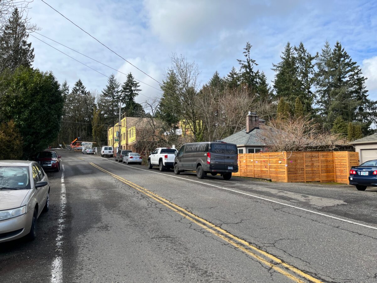
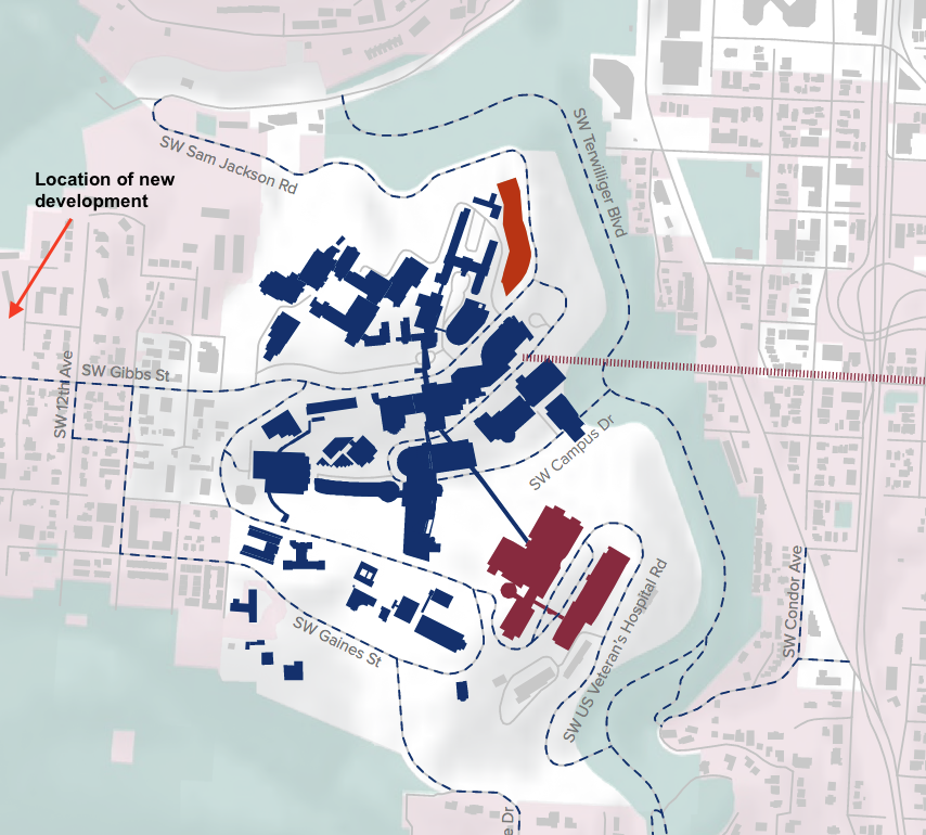
Fischer’s request is part of the Homestead neighborhood’s response to a new five-story, 43-unit apartment building which is currently being constructed on SW Gibbs Street, near the Oregon Health Sciences University (OHSU) on Marquam Hill. As BikePortland has reported, the city will not allow the developer to pour a cement sidewalk on the building’s Gibbs Street frontage.
The construction is well underway, but the developer wants to increase the number of units from 27 to 43. This modification triggered a new round of permitting, including a modified application review by the Hearings Officer (HO). (Presentation of the completed application to a Hearings Officer is the final step in the permitting process for large developments.)
This second HO hearing gave the neighborhood association another opportunity to call-out the limited frontage improvements. In this second review, however, they took the further step of offering pointed criticism of what the city accepts as a Transportation Impact Study.
And the Hearings Officer agreed with them:
Since the law does not require it, the Hearings Officer cannot direct the expenditure of public funds to this project under the facts of this case. In this case, whether to modify the rules to include analysis of pedestrian and bicycle trips and whether to direct PBOT resources to prioritize a fix of the unsafe shoulder is within the sole province of the legislative and executive branch of the City (City Council and the PBOT Director). The Hearing Officer’s non- binding recommendation to PBOT is to use their executive and legislative powers to fully fund the projects identified in the PBOT emails with Mr. Fischer.
In other words, the HO’s hands are tied because he doesn’t have authority to require action from the city. But he thinks the city should do something about the unsafe shoulder new residents will be walking on, and also update city traffic analysis rules which are blind to pedestrians and cyclists.
Portlanders who follow trends in active transportation might be taken aback to see how outdated the city’s administrative rule guiding traffic studies is.
The rule, TRN-10.27 – Traffic Capacity Analysis for Land Use Review Cases, describes minimum levels of service for vehicles at intersections that have either signals or stop signs, but it does not mention anything about people walking or biking.
The purpose of the rule is to determine if the local transportation system is capable of supporting the additional trips generated by new occupancy, but its car-centric bias is glaringly out-of-step with government policies, including city and state decisions in recent years to end parking mandates.
That active transportation omission makes it impossible to analyze transportation impacts in a location like Marquam Hill, where the city began capping and regulating parking twenty years ago. As a consequence of that city policy, OHSU has only enough parking for one in every three employees. This has successfully resulted in many employees and students traveling to the Hill via public transportation, or by biking and walking.
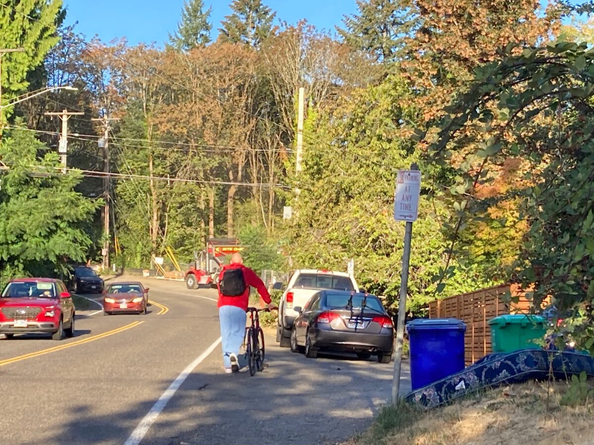
And it has spurred “walk-to-work” development throughout the area, especially on Gibbs Street. But Gibbs does not have continuous sidewalk coverage, and sidewalks are completely missing near the new development.
Nevertheless, PBOT’s Development Review office determined that
… based on the evidence included in the record, the applicant has demonstrated to PBOT’s satisfaction that the transportation system is capable of supporting the proposed use in addition to the existing uses in the area.
This did not sit well with Fischer, himself a retired transportation engineer, who told BikePortland “the city is trying to make walkable neighborhoods.”
To further that goal, he suggested the following five changes to the traffic study administrative rule and the way PBOT reviews traffic studies:
- Require trip generation estimates to include pedestrian and bicycle traffic. (These volumes could affect typical mitigation measures beyond just sidewalks, including crosswalk warrants, signal warrants, bicycle signal warrants, etc.),
- Require PBOT reviewers to visit the proposed site on the ground and to examine, first-hand, facilities and access issues within a reasonable area of interest around the site, looking at likely destinations to and from the proposed development site,
- Require documentation of actual traffic volume and speeds, not make assumptions based on posted speed,
- Require review of recent, planned or proposed system improvements within a reasonable impact area around project site, and
- Require (within the TIS) consideration of the use of System Development Charges to address local needs.
It is difficult to understand why the fate of transportation infrastructure near this economic engine depends on conversations between a PBOT middle-manager and a neighborhood volunteer.
Fischer said that the Homestead Neighborhood Association does not plan to appeal the Hearings Officer decision to city council, but that they are “keeping the momentum up to see if we can get the city to follow through on some of our recommendations.”
“Keeping the momentum up” has involved ongoing conversation with PBOT’s Development Review office about the neighborhood’s new, watered-down goal of prohibiting on-street parking on the road’s shoulder and increasing shoulder width downhill from the new apartments, the direct route to OHSU. (See photo at top.)
Their ultimate goal is a two-block long cement sidewalk, but the city told them that it would come with a price tag of $1.6 million, due to water pipes having to be relocated to avoid being under the sidewalk.
OHSU is the city’s largest employer. In 2021 its researchers brought in over $405 million in federal grants to the Portland area. It is planning a $650 million hospital expansion. Alongside this growth, private developers are filling in Gibbs Street with dense walk-to-work residential projects.
It is difficult to understand why the fate of transportation infrastructure near this economic engine depends on conversations between a PBOT middle-manager and a neighborhood volunteer.
If the city is really committed to its visions of supporting walking, biking and the densification which allows for better public transit, it should follow the Hearings Officer’s recommendation to use its “executive and legislative” powers to build the pedestrian and bicycle infrastructure needed to provide safe passage for OHSU employees, students and neighbors. Infrastructure conversations need to rise a few pay grades.




Thanks for reading.
BikePortland has served this community with independent community journalism since 2005. We rely on subscriptions from readers like you to survive. Your financial support is vital in keeping this valuable resource alive and well.
Please subscribe today to strengthen and expand our work.
Besides the great reporting uncovering the craziness of this particular situation, I love this for touching on so many things that have come up in other articles:
–the disjointedness of City government–while some of PBOT is busy on biking and walking projects, another arm is reviewing projects under the premise that biking and walking are irrelevant to transportation
–there’ve been lots of “neighborhood associations are all NIMBYs” comments, but here’s one that brought up an issue with PBOT reviews whose correction will help the whole city
–one roadblock to testifying or commenting about issues is the “leave it to experts” stance, but here’s an example of a neighbor having obvious technical knowledge that allows them to identify a problem with PBOT reviews that all of PBOT has apparently been unaware of or unable or unwilling to fix
–the way City processes are set up so it’s easy for bad things (PBOT’s approval of no sidewalks) to slip through unless it–almost by chance–gets noticed by a neighbor or someone outside the review process who knows how to object
This line from the article really sums it up well:
“It is difficult to understand why the fate of transportation infrastructure near this economic engine depends on conversations between a PBOT middle-manager and a neighborhood volunteer.”
Traffic impact studies don’t count pedestrians or cyclists?! Is this a city-wide issue? That seems incredibly bad to me. How many projects have had to overbuild a parking garage, or perform some kind of scope reduction because PBOT didn’t bother considering people walking to and from to get around?
Pretty disappointing stuff
It’s an industry-wide issue and a legacy of auto-centric engineering and planning. Good news is many agencies, consultants, and academics are looking for alternatives and ways to better account for non-auto travel in TIAs. That said, there are legal complications (i.e. clear and objective standards) and a lack of good data/precedent that make this work difficult. Kudos to Lisa for digging into this subject – it’s a critical factor in understanding why our built environment looks the way it does today.
I was under the impression that PBOT would use whatever transportation demand tool they have to do the modeling for a new development/land use change, and that those tools are supposed to have a mode split when determining trip choices. Is that not the case?
I’m curious, blumdrew, what led you to that impression?
My observation and experience have led me to believe that there is a chasm between the aspirations of non-binding city transportation plans and the city code that governs what actually happens. This chasm is reflected in dueling philosophies at PBOT.
The Planning office (which, incidentally, is what most BikePortland readers are familiar with) designs the large capital projects that BP commenters like to critique, things like 122nd and 82nd, Capitol Highway, and all the “in Motion” plans. They are forward-thinking about active transportation.
Then there is the Development Review office of PBOT. They review the transportation impacts of proposed private development for BDS. Most bureaus have an equivalent office — water, fire, forestry all need to sign off on large proposed development. Most BP readers are blissfully unaware of all this. But it’s the business of the land use and transportation committees of neighborhood associations to be familiar with it.
DR is governed by hard, binding city code because they are working with developers who are usually taking large financial risk. PedPDX and the Bike Plan do not matter to these folks, and they aren’t legally bound to consider them.
In the intervening decade between passing the Bike Plan and PedPDX, the city council passed a small, boring change to a paragraph of city transportation code which watered-down the individual frontage requirements for new development. In its place was a suite of improvements which could be met on balance. In other words, a developer didn’t have to do all of them. Quite a loophole, and a competent land use attorney knows how to maneuver through it.
What can I say, do not ignore the man behind the curtain, that’s where the action is. I remember hearing the late Nick Fish, when presented with phone book-sized plans, asking at several council sessions, “Is there anything binding in here?” If there wasn’t he went ahead and voted for it.
Probably being a bit naive. I was reading through some transit planning docs for a BRT line in my hometown (Madison) yesterday, and saw a lot of references to their transportation demand modeling. And I’ve certainly seen it referenced in larger plans – I guess I don’t often get in the weeds with specific projects and city code though. I suppose I figured that the same tools would be used, since what else would they do?
I will say the gap between binding city code and aspirational plans both makes sense and really stinks. What’s the point of making an aspirational plan if the framework to carry it out doesn’t exist? (a rhetorical question – I realize it’s to posture to voters, etc. that we are “progressive”).
Demand modeling is typically done at the plan level, to make sure that the plan will address all the transportation needs. Like a comprehensive plan or a transportation system plan. Demand modeling is never done for private development. They instead do these Traffic Impact studies, which take their anticipated trip generation and see what that does to the local traffic system using micro-simulation. They’re two totally different kinds of modeling, macro vs micro.
Yep – a lot of civic fealty to active transportation is purely performative. It looks good to support it, but when local gov’t gets down to the hard details about who will pay for what, developers find a way to win, unfortunately.
Folks reading this might also be interested to know that these requirements apply only to projects that have to undergo a “Land Use Review.” There are certain large projects, that, while needed in the community, are not subject to Land Use Reviews. For example, the proposal to more than double the number of units and roughly quadruple the residential population at Peaceful Villa, an affordable housing site adjacent to Clinton Street, does not require a Land Use Review. No assessment of things like like safe routes for kids to get to Creston School/Creston Head Start/Creston Park; impacts of more traffic on Clinton Street for cyclists and pedestrians; and the impact of making Woodward a through street on neighborhood circulation, including cut-thru traffice. None of this needs to be analyzed at all.
Seems fine to me. More affordable housing is what the city needs.
And I’m not sure how Woodward will be made a “through street” when it dead ends on both sides of Peaceful Villa.
Streets like Clinton that are Safe Routes to School should have enough diverters and calming to stay safe regardless of the land use surrounding them. Clinton is maybe the only greenway in the city that comes close to having enough diverters – although I would say one is badly needed somewhere between Cesar Chavez and 50th. And that this need is present regardless of the number of people who live at Peaceful Villa.
As for Creston Park, I would say crossing Powell Blvd is probably of far far larger concern safety-wise than marginally increasing residential density. That crossing at 42nd/43rd is awful.
The issue is not the project. The issue is that there is absolutely NO public review and no requirements for a traffic impact analysis or other impact/mitigation review. We are FOR the project, but we want the developer to be realistic about impacts to transportation, including pedestrian/bike, especially as it relates to kids. The elementary and head start for the area is Creston, across Powell. Increasing the number of kids who have to cross Powell should be a trigger for improvement to at least one crossing. Area users are also concerned about potential motor vehicle increases on Clinton, and car-bike crashes at the 45th and 47th intersections with the increased traffic to/from the site (including during construction). This development could be the trigger for another diverter on Clinton between Chavez and 50th, IF a valid traffic study were done.
They are going to build a 2-lane public street connecting the two dead ends of Woodward, which, because there is no public land use review of the project, is not out in the open.
This has been the case in Oregon since the 1970s. Plenty of other states do land use reviews for every single development, and the result is more NIMBYism, less development, less housing, more parking, more road capacity. No thank you, I’ll take Oregon’s best-in-the-nation land use planning system any day.
This took an incredibly concerted effort by many activists and advocates and the result does not suck. Now, neighborhood greenways are to be criticized or de-emphasized even though similar bike streets make up a significant part of the bike network in the Netherlands and Germany. It seems to me that some cycling enthusiasts are engaging in Numtotian “protected bike lane map” fantasies that are almost as absolutist and wrongheaded as the inflexibility of the prototypical vehicular cyclist.
Yeah, the Clinton greenway is one of the best places to ride in the city. The diverters work, and should be widely implemented on other parts of the greenway network. Greenways are good when they are well designed and cared for (like Clinton), and not so good when they are (seemingly) hasty attempts to check a box (16th, Salmon, etc.).
What about wanting protected bike lanes/raised paths on main streets (Belmont, Hawthorne, Milwaukie, Mississippi, etc.) is “absolutist and wrongheaded”? Having poor accessibility to the most visible, vibrant, and active spaces in the city makes cycling a less attractive option. Greenways are one part of a functional bike network, and it’s frustrating that it’s the only part we seemingly will ever get.
PBOT’s failure to add a bus or bike lane to Hawthorne and to address the increase in cut through traffic was a wasted opportunity to demand more diversion on SE Salmon, ATMO.
Nothing. My point is that protected bike lanes and dutch-style bike streets are worth fighting for.
After looking it up for the second time, NUMTOT: New Urbanist Memes for Transit-Oriented Teens.
I don’t get it. I’m unsatisfied with what Portland calls “greenways” because they aren’t especially green, they’re not a great riding experience physically, and the layout is slow and generates a dangerous amount of motor vehicle conflict. I wish that made me an idealistic teenager but the mirror says, not.
A second class street labeled a greenway is not a better bike facility than any other street in the grid. Turned stop signs lure impatient motor vehicle operators and speed(ing) bumps are exactly a pain in the ass. Why settle for a greenway that is fact no more than a few stray signs and some plastic that will pop off the pavement and go into the ocean?
I don’t disagree with any of this. Neighborhood Greenways shuld be like (or, IMO, better than) SE Clinton. And given how incredibly inexpensive it is to improve NG’s this need not detract from protected bike lane advocacy.
Thanks to the folks in the Homestead Neighborhood Association for pursuing this issue!
“If the city is really committed to its visions of supporting walking, biking and the densification which allows for better public transit, it should follow the Hearings Officer’s recommendation”
Well, my first instinct is to fill this whole page with HAHAHAHHAAHHAHAHA but that would be juvenile. Satisfying, tho.
Development services seems fully on board with developers, and will spend much time, energy and tax dollars helping them avoid infrastructure requirements, and usually none on helping figure out how to get something for neighborhood bike/ped safety. The actual quote from a DS staffer to a group of SW ped/bike advocates: “My boss told me: ‘maximum density; don’t get me sued.'” Meaning ‘go out of your way to not have Nollan/Dolan even enter the mind of a developer.’ It’s beyond institutional cowardice; it’s hostility to the other half of their bureau!
As for changing their ways – they like the antiquated, insufficient traffic rules which continue to allow them to abet developers; pretending when Wally and Beaver’s dad goes to work, and Mom goes shopping and to beauty parlor, that’s maybe 4 or five trips. repeat when Dad comes home, and maybe goes to liqour store. See, practically no added impact at all per household! Rarely accounted for are deliveries, services, landscapers and any others who might now be on a road after new development. Peds and bikes are not important users; why, they take up hardly any space at all! Especially in Portland….
To be fair, those traffic engineering calculi are used throughout the US, but the ped part, as others mention, not so much. Portland, however – my neighborhood was involved in a land use case where one of the DS arguments was that since no cars from the development would pass a certain stretch of ROW, the developer didn’t have to improve it, despite it being a place people already walked. No cars, no foul.
For Gibbs, as I have stated months ago, PBOT claimed there was no ‘connection’ (i.e. sidewalk) for peds to go to, so no reason to improve the ROW… even though they tell us the ROW IS the connection in SW. They can have it both ways, because they actively choose to do so. This isn’t going to change unless PBOT leadership and management change.
Thank you for reporting on this, Lisa. I agree with your closing statements. And thank you, Ed Fischer, for your suggested changes. They seem very resonable to me.
Q: Do you know if The Street Trust or Oregon Walks have weighed in on Ed’s proposed changes? It seems to me that one or both of the organizations could take the lead moving them forward.
FWIW, I’d like to see both organizations speak up more often on BP.
In addition to inadequate traffic analysis, PBOT suffers from amnesia regarding the numerous transportation plans it churns out and the beautiful aspirations they contain. Southwest In Motion (SWIM) has two “Top Tier” improvements identified for this portion of Gibbs/Marquam Hill, which are on or adjacent to this development’s street frontage. I can’t determine which would apply directly, but SWIM calls out Gibbs sidewalk (Project BP-07) and Marquam Hill safer shoulder (Project SS-03) in this area where Gibbs and Marquam Hill meet. Why wasn’t this part of the conversation? If not now, when would these high priority ped/bike improvements along this frontage be done? What time would be better? Do we do it now or wait for Santa Claus?
Unfortunately, this is a routine performance. Perfect improvement opportunities are missed as PBOT plods along with the blinders on and ignores the plans it created, such as the Portland Bicycle Plan for 2030 and SWIM. PBOT complains about insufficient funding (which is an issue) but then repeatedly blows opportunities like this.
We wait for Santa Claus.
Sadly not limited to PBOT. We see the same thing happen regularly in Washington County. Cornell Rd has been a prime example where they have allowed people to build things, such as a large assisted living facility, or new housing development, without putting in a stretch of bike lane along it. Then they tell us it would be too expensive to put in bike lanes because such a large stretch would have to be improved by the county. Yet they completely skip putting the burden on the developers. It’s absolutely infuriating.
Contrast our situation with many cities in California: I lived in one where *EVERY* new development had to improve the street and add bike lanes and sidewalks as a condition of development. In other words, nothing could get built until the street was improved FIRST.
It produced a rather weird streetscape where you get short stretches of bike lane and sidewalk that end suddenly, and the city fills in when it can get funding. But at least the developer did her part.
I know, I know – Portland imposes “system charges” that they say they put into more continuous street improvements, but they don’t seem to add up to anything close to having a developer improve the street she most impacts.
Thank you Lisa and thanks, BP, for keeping this in view. Walking Critical Mass anyone? It should be clear enough to everyone that OHSU can’t continue to operate on the hill if there are not sufficient alternatives to SOV transport.
It’s excessively grim to say it but what we’ve seen before is that someone is killed, then it is suddenly time to build something.
Hello, Commissioner Maps.
Commissioner Mingus Mapps (autocorrect, sorry) is in charge of both parts of PBOT, the one that hugs bikes as well as the one that enables large scale development without sidewalks.
Neighbors of mine replaced their single house, adding about 50% to the ground plan, and the city mandated full length sidewalks, curb, and storm sewer development on a street with no sidewalks for blocks around.
When the old ‘sheep farm’ on Patton was redeveloped, the new single family residence (SFR) was made to put in hundred+ feet of sidewalk, regrade the drainage ditch, pave hundred+ feet of shoulder AND put in a handicap ramp – on Patton, where no sidewalks exist (or, if PBOT has its way, will EVER).
JUST down the road, a developer wanted to put 11 houses on a lot less than 100 yards from Scholl’s Ferry. That developer was told to pave maybe 10 feet of the shoulder in the ROW. SFR = full ride. Developer = no prob, Bob!
I suggested the homeowner sue (he estimated ROW work was 15% of project, waaaaay more than it appears developers are calculated to require), but he just was glad to be out of their hands. Note this was county, in both cases, but apparently PBOT had say on ROW.
I use that sidewalk by the old sheep farm – it’s a nice refuge when you’re dodging cars the rest of the way.
That’s a great example of how the system works – er, doesn’t work. Thanks.
Traffic Impact Analysis under Oregon law only applies when a property owner is requesting a zoning change or comprehensive map amendment. This is pretty rare, and so this whole discussion is irrelevant to the vast majority of land use cases. Yes, it should probably be reformed to include ped/bike trips, but it won’t make all that much of a different.
I should add that it’s a very good thing that Oregon is one of the few states that requires cities to plan for capacity needs at the time of Comprehensive Plan adoption rather than having every new development do a TIA. In most states, doing TIAs for everything results in too much parking and too much auto capacity. Our system in Oregon is much better.
SDCs were brought up in the article as a solution, but developers can only use SDCs for improvements that are on the adopted SDC list of projects. I’m not sure if this street would be on that list, but it’s possible that it isn’t so it might not be eligible. There’s no legal basis to allow SDCs to be used at just any old location–it has to be in the adopted plan. Even then, the city can say no if they would rather use the SDCs elsewhere.
It seems like they used to. At least for a while.
The City of Portland has thus far been unable to use these powers b/c our so-called legislators have been busy running bureaus.
Congrats to everyone who voted for charter reform, which will give legislators the bandwidth to tackle issues like this one, which should be no-brainer, in 2025.
…and the need to replace the water main because it would be under the new sidewalk is complete BS.
Hopefully the new City Manager will callout the the water bureau’s complete lack of flexibility.