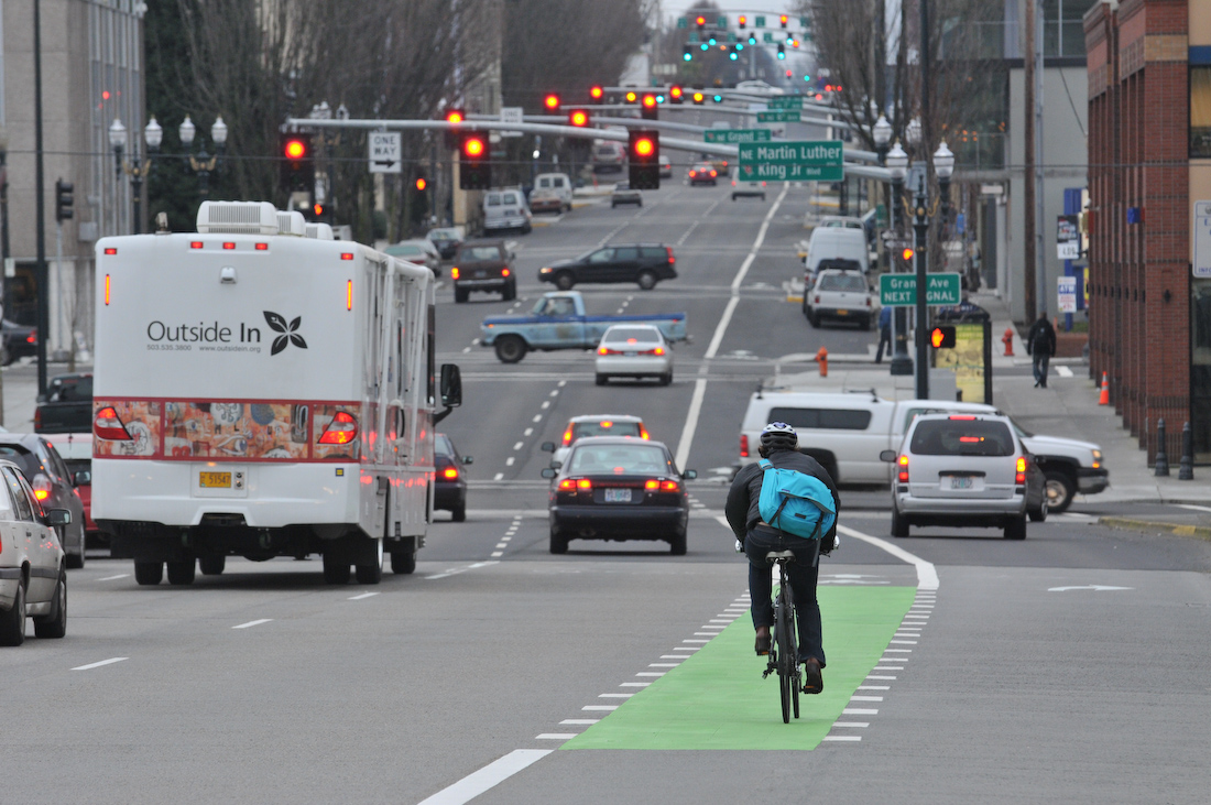
This week, the Portland Bureau of Transportation begin work on the East Burnside Rose Lane project. This project is part of PBOT’s Central City in Motion (CCIM) plan to speed up transit and improve infrastructure for people biking and walking.
A Rose Lane on east Burnside is being installed to improve transit times for TriMet bus lines 12, 19, and 20. Its construction will also bring some new bike infrastructure that PBOT hopes will make the entire corridor more appealing to new and existing riders.


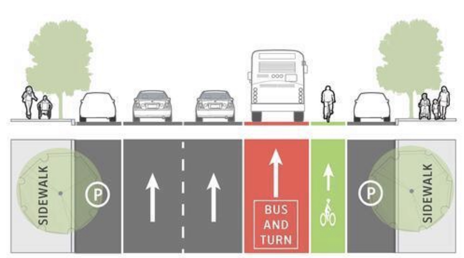
Right now, there is a ‘bus only’ lane on the Burnside Bridge that ends at Martin Luther King Jr. Boulevard. This project will extend that bus lane to NE 12th Ave. As with other bus lane locations, PBOT will consider this a “bus and turn” or BAT lane where drivers are permitted to enter only to make right turns. This stretch of Burnside currently has three general travel lanes (four just before 12th), a bike lane and parking lanes on both sides. PBOT will swap the southernmost general travel lane for the BAT lane.
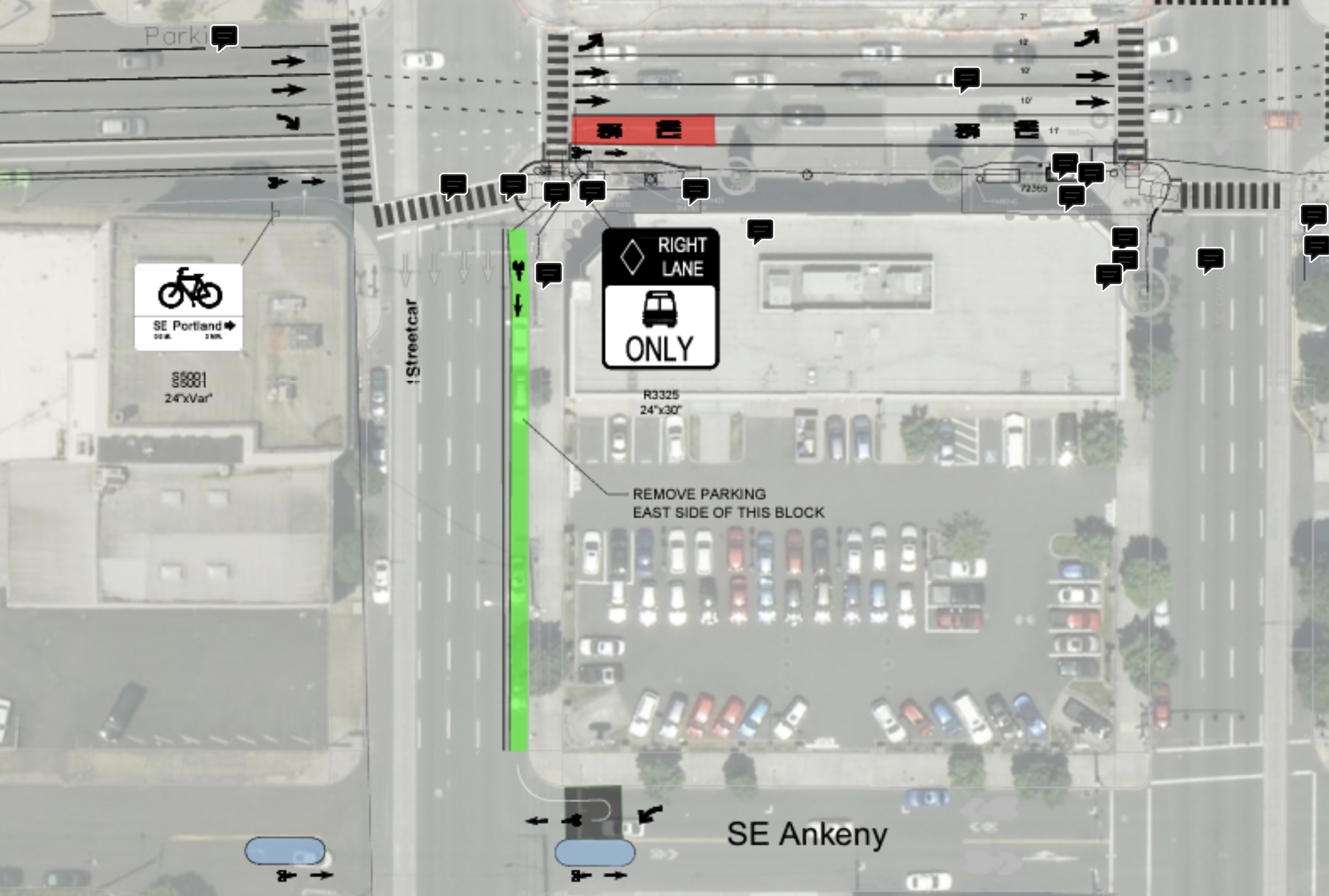
Between MLK and Grand, PBOT will remove an existing curb extension and car parking spaces to make room for the BAT lane.
A signal upgrade at MLK and Burnside will create a separate phase for buses, bikes, and car drivers. This will give bike riders time to cross Burnside and connect to a new bike lane PBOT plans to build on the east side of MLK for one block. The new bike lane will take the place of car parking. It will be the recommended route for riders traveling eastbound from the Burnside Bridge who want to connect to the SE Ankeny neighborhood greenway (see plan drawings above). PBOT will add a median diverter to calm traffic and reduce driving volumes on Ankeny.
It will also be the first bike lane we’ve ever had on MLK, which is an ODOT-controlled state highway (99E)! (Right?)
This is one of several CCIM projects PBOT has been working on over the last few months. People biking in inner Portland may have noticed recent progress on the SW Broadway bike lane and the SW Alder Rose Lane. Across the river and parallel to Burnside there’s the NE Couch Rose Lane and bike lane extension that PBOT constructed in August right after the carfree Blumenauer Bridge opened to the public. There’s also the new bike lane on SW Main Street in between 3rd and 4th Avenues (the ‘Elk Lane’): a small bike connection that should give a boost to nearby CCIM projects by helping form connected central city bikeways.
PBOT says it will take about 12 months to complete this project. Keep your eyes peeled for lane closures and construction zones.


Thanks for reading.
BikePortland has served this community with independent community journalism since 2005. We rely on subscriptions from readers like you to survive. Your financial support is vital in keeping this valuable resource alive and well.
Please subscribe today to strengthen and expand our work.
seriously?! Umm, you could make the same turn onto MLK and use the far left lane.
No need for a special one block bike lane where you’d have to stop at Ankeny and look over your shoulder to make sure no one from the car lane is about to turn into you. Or better yet, stay on Burnside until 6th so that you don’t have to wait again at a light on Ankeny and Grand.
It’s kind of hard to tell from that picture, but it looks like there’s possibly going to be a diverter there so cars can’t turn left from MLK onto Ankeny?
If you go from Burnside to MLK south to access Ankeny, you will have your own signal cycle. No cars will be behind you when you make the turn onto Ankeny because they will still be stuck at the red light.
an extra signal that is not needed.
I would rather have a dedicated bike lane than “take the lane” any day. And not everyone wants to wait until 6th Ave to cut over to Ankeny.
And not everyone wants to wait at a guaranteed red light at Grand and Ankeny when they can just continue with the signal progression on Burnside.
That doesn’t make any sense. If you have a green on Burnside at MLK, then turn right at MLK and left onto Ankeny, you should still be able to catch the green light at Grand. That’s how signal timing works.
And you have that choice. You can stay on Burnside and go straight with the green. Cut over to Ankeny east of Grand whenever you please.
you’re hardly “taking the lane”. The traffic behind you would still have a red and it’s only a small distance, Buster.
I really don’t like riding in bike lanes sandwiched between bus and parking lanes. People dart from the rightmost car lane, across the bus lane and bike lane to get to parking spots without really looking out for bikes. Why not do something similar to what they did on Hawthorne, where it goes car lane/car lane/bus lane/parking/bike lane? That feels like it at least makes the right hook close calls more predictable. Or just remove the street parking entirely? The east side is just lousy with parking lots.
Appreciate the signal changes and diversion on Ankeny though.
There is already curb extensions where there is parking so doing so would require more than just paint. With Hawthorne they didn’t have to move the curb at all. Ideally they fill in the curb where the parking is.
Seems like these Rose Lane projects are mostly for bus improvements with incidental bike/ped improvements. I don’t like the idea of being sandwhiched between car lanes and parking either, but at least the width of the bus lanes will give bicyclists more time to react for when cars dart over for parking.
MLK/Grand is PBOT maintenance from NE Lombard to SE Powell (or SE Woodward which is one block north of Powell), not ODOT.
Fun fact: the road number designations can also occur on city-owned streets.
https://pdx.maps.arcgis.com/apps/webappviewer/index.html?id=322fb44af46e48de9345dd491f5dc437
Yeah, people seemed to get tripped up by the highway numbers, but those are just a way-finding system and don’t have much meaning in real life. 82nd Ave will still be signed Hwy 217 even though it belongs to PBOT now, for example. And Interstate Ave is still 99W and MLK is 99E even though they are not state highways anymore.
The only example I can think of where a street lost its highway number with the jurisdictional transfer is NE Sandy Blvd, which was Highway 30 until the transfer. Highway 30 was moved to officially be I-84 between I-5 and I-205, then it hops back onto Sandy east of I-205 where it is still an ODOT highway.
Also, just to be fair, the only section of MLK that has bike lanes is actually the ODOT-owned portion north of Lombard. Of course, they are absolutely terrifying bike lanes to ride in…
It’s a shame the bike lane on MLK is on the east side of the street. A bike lane on the west side of the street would have provided the same level of connection from the Burnside Bridge to eastbound Ankeny, while providing a much better connection to the blocks of between the river and MLK.
Looking through my emails I see that two years ago PBOT staff said that they’ve moved the connection from the east side to the west side of MLK, so it’s too bad to learn that that didn’t ultimately happen.
Totally agree! Comming off the bridge, I would use MLK to head west/south, but I would continue east to 6th to head east/south or north. The bike lane would be better on the west side.
There’s a streetcar on the west side of the street.
I’m well aware of that. What I’m suggesting is removing the parking on the west side of the street instead of on the east side.
Wouldn’t there still be a sketchy crossing of the streetcar tracks at the southern end? You would be riding parallel to the streetcar and then pivoting 90 degrees to cross the tracks. That sounds difficult and very dangerous.
The curb extensions make this very difficult. They would have to route the bike lane awkwardly up and through the streetcar stop and then back down to the road surface, creating new curb cuts on both ends. And then they would need to make a turn box at Ankeny, and you’d have to wait for that cycle to change as well.
Ideally this project would have been coordinated with the Public Works Permit for the MLK project, however even though it wasn’t my understanding is that PBOT had a solution to this issue. For someone heading east on they’ll hit the same number of signals, whether they cross the MLK/Grand couplet at Burnside or on Ankeny (and can choose between them).
In any case my understanding now is that the drawings on PBOT’s website are out of date, and the bike lane will be on the west side of MLK.
Precisely why the parking lane on the west side should be removed for a bike lane instead.
*and move the curb
*and move the streetcar stop
Agree. West side would make for a better connection to central eastside.
The PBOT graphic is outdated. PBOT’s Gabriel Graff confirmed to me last week that the Burnside-Ankeny connection will be on the WEST side of MLK. That means that people like me who want to go south can connect from the eastbound bridge to streets like SE 3rd or 2nd. That change was made a long time ago. It’s too bad PBOT never updated the maps on the project website.
MLK Jr Blvd from Lombard all the way down to McLoughlin is a city-owned street even though it continues to be signed as 99E. It is not ODOT-owned and hasn’t been for decades.
Will the East Burnside bike lane be a protected lane? The illustrations suggest it doesn’t even have plastic wands.
Since bikes would only be using it on an exclusive signal phase, and it’s only one block long, does it need protection?
This is timely. Now that the Blumenauer is live, I ride east Burnside often to get to Ankeny’s safe route home. I hate traversing Sandy/7th on Ankeny since sight lines are limited, speeds are high and drivers are… well, drivers.
In addition, I always find a ride share driver/someone picking up/dropping off blocking about 20% of the right travel lane and 110% of the bike lane regardless of open parking spots on the block they’re sitting idle (between mlk and 12th). Having the bus lane there gives me more room to dodge the boulders without worrying about the traffic encroaching from behind.
I often find myself in a similar situation. I was riding home last night and had to dodge around 4 cars with their “park anywhere” lights on in a 6 block stretch of Burnside. I’m a little cynical about the red paint though. It seems to work ok elsewhere, but it seems that drivers are often so distracted by their phones/coffee/passengers/dashboard ipads that they fail to recognize that they are driving on a big ol’ red lane with “bus only” written on it.
It’s disappointing that the curb extensions are being removed at Burnside and MLK. This will reduce walkability in the area and frankly, it’s the north-south connections that this neighborhood so sorely lacks. This change is still a huge net good, but I hope something can be done to make the Burnside crossing safer. This is one of those areas where drivers routinely speed and run the red.
Terrible idea. Why are they taking more lanes away from busiest streets? PBOT is responsible for air pollution, traffic and more traffic deaths with these performative but useless, in fact, downright silly ideas. This along with their horrible ideas of unused bike lanes in the east side while taking lanes from busy traffic just makes life far more difficult for poor people, POC, and also makes life much more dangerous. PBOT is insanely incompetent and only knows how to put paint on asphalt and listen to radical bicyclists. This is a TERRIBLE idea that will make traffic worse and cause more traffic with air pollution to follow.