
“The question is do we want to increase capacity, and I say no.”
— Jo Ann Hardesty, Portland city commissioner
After months of analyzing options for what a remade I-5 could look like between Washington and Oregon, the Interstate Bridge Replacement Program today put two options on the table: a highway expansion with the same footprint as the 2013 proposal for the Columbia River Crossing, or a second option, which shaves off 16 feet and includes one fewer “auxiliary” lane in each direction.
Focusing heavily on the short distances between the seven interchanges included in the project (below), the project team Thursday touted reduction in crashes that could come from adding additional auxiliary lanes, an argument familiar to anyone following our coverage of the I-5 Rose Quarter project. But future auto travel times were front-and-center, using a model out to 2045 that includes the Rose Quarter project as a done deal.

“Auxiliary lanes…are not through lanes and not the same as adding an additional lane,” the voiceover stated on a video shown to the IBR’s executive committee promoting the benefits of “ramp-to-ramp connections”. But Washington DOT Secretary Roger Millar wasn’t convinced that they had enough information to make a full assessment of the safety benefits that could come with one or two more lanes. “I need to see safety data, because that’s what we were selling aux lanes on before. That will be more important to me than saving two minutes 25 years from now,” he said.
The travel time forecasts are all over the place, with a trip from I-205 in Vancouver to I-5’s connection with I-405 in Portland during traditional morning commute hours still expected to increase from 29 minutes to 57 minutes with the addition of two auxiliary lanes compared to 63 minutes with no project at all. But the projected decrease in travel time heading the other direction, from 38 minutes in 2019 to 15 minutes with two auxiliary lanes, is clearly central to the entire project. Millar, calling those travel times a “bright shiny option”, suggested they were a fantasy and that the road capacity would be filled by induced demand, though he didn’t use that term himself.
Advertisement

A two-auxiliary lane option could mean a 12-lane I-5 through Vancouver, which will already be significantly impacted by elevating I-5 through downtown, as renderings released earlier this month show. The diagrams also suggest that only adding 1 auxiliary lane would have less of an impact on Hayden Island.
It’s clear elected leaders still have a lot of questions about this project but the momentum to get everyone to sign off on a Locally Preferred Alternative by the start of summer is intense and would take a lot of effort to slow down.
Portland Commissioner Jo Ann Hardesty did not express any confidence in the traffic models being presented during her questions to project staff but was instead pushing the highway project to expand its definition of equity, which the presentation framed as increasing modal options and vehicle travel times for everyone. “Equity is more than increasing modal options,” she said. “Equity is also about ensuring that we’re not exacerbating costs for low income community members. Your equity definition should be expanded.”
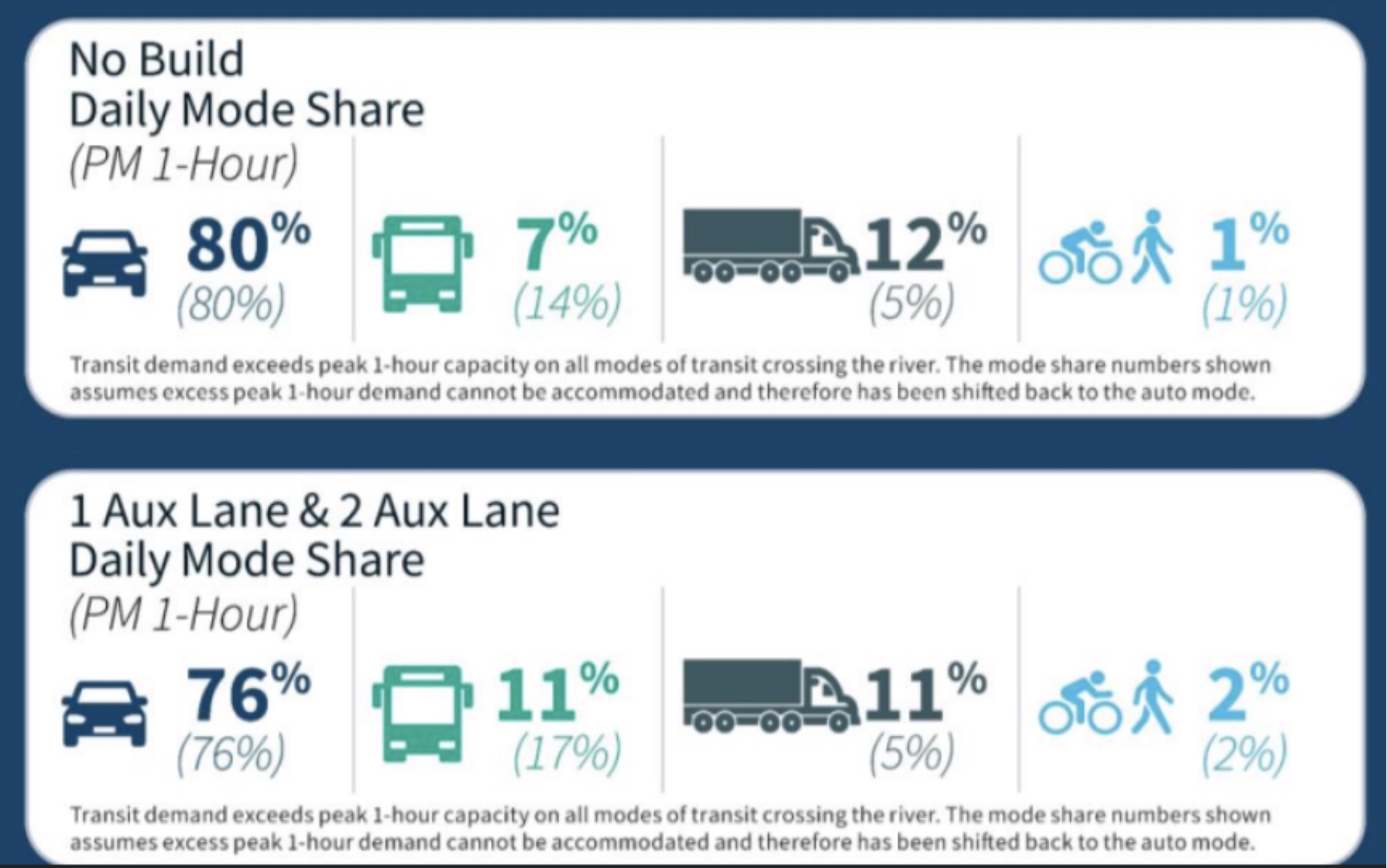
With a wider I-5 with either one or two auxiliary lanes, the project is only projecting the percentage of people crossing the bridge by walking or biking to increase from 1% to 2% in the next two decades, with the share of people crossing via transit increasing from 7% to 11%. (We’ll have a separate full post on the transit options up soon.)
“In your modeling, are you assuming that human behavior will change at any point between now and 2045?”, Hardesty asked in a primarily rhetorical question to project staff, expressing a desire to see the region move toward not oriented toward getting around via car in the next two decades. “I don’t know how we can model for 2045 without taking into account climate, and BIPOC communities and how they’re going to be impacted by this,” she said. “The question is do we want to increase capacity, and I say no.”
Metro President Lynn Peterson, on the other hand, signaled that she thought the one auxiliary lane option was closest to what the Metro Council, which includes some of the project’s most skeptical voices, has been advocating for. Shaving one auxiliary lane off the project could save $75-$100 million dollars out of what could be a $4.8 billion project. In two weeks, we’ll learn whether the full blown Columbia River Crossing option has been the one picked to move forward, or its slightly slimmed down version.
It’s clear elected leaders still have a lot of questions about this project but the momentum to get everyone to sign off on a Locally Preferred Alternative by the start of summer is intense and would take a lot of effort to slow down.


Thanks for reading.
BikePortland has served this community with independent community journalism since 2005. We rely on subscriptions from readers like you to survive. Your financial support is vital in keeping this valuable resource alive and well.
Please subscribe today to strengthen and expand our work.
How does making it harder for people to travel by car help equity. Does Hardesty think people of color don’t own cars?
I think the point is that car-dependency is inequitable. The cost of car ownership (in the thousands of dollars per year) adds significant hardship to the lives of so many who are living paycheck to paycheck. An equitable transportation system would provide viable non-car options so that folks don’t have to accrue debt just to get to their jobs.
I would think that since Commissioner Hardesty works for Portland, making it easier for people, regardless of color, to travel by car to cities in another State is not in her purview.
The externalized costs of a making it easier for out of state residents to drive through communities in this city, is.
How are the tolls that come with this $5 billion project going to help with inequity?
Some of the inequity of freeway expansion is the health costs of people living near a freeway
From my experience the most diverse place in Portland is the public transportation. As people of color statistically have less money than white people, they tend to live in areas that are inhospitable to people walking or biking, not the fancy green neighborhoods where car traffic is slow. That puts their health in jeopardy, specifically the health of kids that still do a fair bit of walking and biking.
And Vancouver’s Council unanimously agreed to support LRT (MAX) crossing the bridge into Washington State. Which is a “big give” to the Portland area…so now scratch Vancouver’s back…with _____*____. [*Tolling, another non-aux lane, closing I-5 direct ramps to Hayden Island, on-bridge layovers for transferring sales tax-free commercial purchases between trucks, air conditioned bike / pedestrian path, no Oregon Lottery machines on the bridge belvedere, etc.]
“Could be a $4.8 billion project” multiplied by (1.3 to 2.5 times the estimate with mega-projects ODOT is involved in) = $6 to $12 billion project – pretty much something that’ll swallow the whole state transportation budget, stealing from projects around Oregon.
Gotta include likely cost-overruns before reporting these numbers as factual.
Read more here.
Re: “Auxiliary lanes…are not through lanes and not the same as adding an additional lane”
Auxiliary lanes do not last for 4 miles in direction, as proposed!
But worse, the highway departments are not just widening the road by 2 lanes or even 4, they are actually proposing adding 4 to 8 additional lanes for over 4 miles from Marine Dr to North Main St in Vancouver, compare to the current 3 to 4 lanes in each direction!
In downtown Vancouver, between SR-14 and Mill Plain, there would be 16 lanes, 8 more than at present, in “2 lane” option. But even the “1 lane” widening actually proposes 13 lanes at this point, 5 more than today. You can see this by counting the lanes in the ramps to Mill Plain and SR-14, which overlap.
Currently there are only 3 lanes in each direction in the bridge section, except for 1/4 mile in Vancouver between Mill Plane and the WA-14 ramps, another 1/4 mile over the harbor south of Hayden Island. The southern “auxiliary lanes” will be 4 times longer, and there won’t be just 2, there will be 6 in the “2 lane” option, or 4 in the “1 lane” option.
The main roadway will be 3 or 4 lanes wide as shown, but look at where the ramps to Hayden Island and Marine Drive enter and leave: these add 4 more lanes over the harbor, 50% more than it appears.
The diagram above also shows that the beginning of the bridge will be 11 lanes wide on each side, instead of the current 3 lanes each. With wide shoulders, the new bridge will be more than twice as wide as the two current bridges.
For the section in northern Vancouver around 4th Plane Blvd and SR500, WADOT seems to be proposing at 7 to 11 lanes instead of the current 8, for about 2 miles, according to a simple reading of the diagram. But with counting the lanes leading to Hwy 500 and 4th Plain Blvd, there will be 14 lanes, due to long weaving ramps: 6 more than today.
The same trick is happening on the south end. In Portland, the lanes to Hayden island somehow disappear from the diagram before the harbor, but obviously they are still there to the side, on separate smaller bridges. This adds 6 extra lanes over the harbor before Hayden island.
The only place that the “2 lane” proposal only adds 4 lanes is on part of the main bridge over the Columbia, everywhere else there will be 6 to 8 new lanes.
Comment of the week. This is the kind of critical analysis we need. ODOT is clearly trying to deceive the public with this diagram.
With a budget that size, $75-$100 million is basically a rounding error.
Wikipedia says the Glenn Jackson Bridge (4 lanes each way, and more than twice as long as the Interstate Bridge) cost just under $170 million in 1982. Per the inflation calculator I found on Google, that would be about $507 million today.
We should be looking at a $500 million freeway bridge here, plus whatever it will cost to strengthen and rehab the existing bridges for arterial traffic, transit, and bikes.
We seriously need to throw the whole project out, and start from scratch.
There is also the cost of expanding the max. And you are assuming that labor and materials are the same cost.
Two reasons why not to worry about this anymore: (1) The Big One is already about 20 years overdue, and (2) that newly discovered 80 mile wide comet heading directly toward Earth.
Yes, it’s a real gamble. Will they start the new bridge before or after the nuclear war over the Ukraine, or Donald Trump gets re-elected, or all the glaciers and polar ice caps melt, or Oregon passes a statewide sales tax, or the New York Times removes their paywall, or Portland has a 25% bicycle mode share. It’s just so difficult to know…
I suppose we should all be happy that they included a bicycle icon in their graphics – shows how very, very green this project is!
It’s not just a repeat; depending on the direction they go on the aux lanes, CRC 2.0 stands to be worse (if you can agree worse means less-good multimodal options with much more space for driving) than CRC. Recall that at this same meeting, they also decided on a light rail option that doesn’t directly access downtown Vancouver, sticks to the I-5 fume- and noise-shed, and stops short of Clark College – all “worse” than the transit component of the CRC which at least got you to Clark College via downtown Vancouver. Not sure how what we’ve learned about transportation, land use, or climate change in the last 10-15 years suggests we should be turning the dial down on transit here.