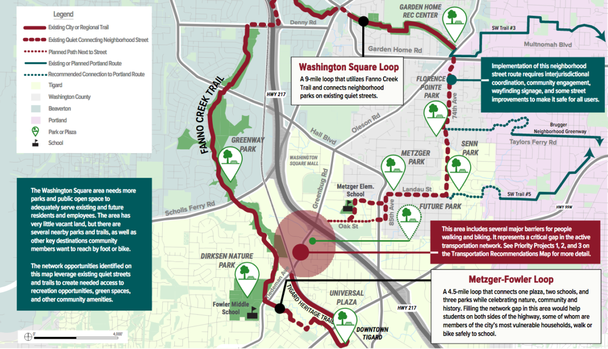
Over the next few weeks, The City of Tigard will review an ambitious redevelopment plan for the area around the Washington Square mall which they are calling the Washington Square Regional Center (WSRC). The Draft Final Report has a number of recommendations for improved active transportation, including:
– a possible Hwy 217 over-crossing at 95th Ave to make bicycle and pedestrian connections to the Fanno Creek trail to the west
– filling in missing sidewalks and bike lanes on Greenburg Rd, Hall Blvd and 87th and 90th Avenues.
– improved crossings at major intersections
– the Washington Square Loop, a nine-mile bike and walking facility which will leverage existing quiet streets and trails.
Advertisement
The first plan for the WSRC was drawn up in 1999 and “envisioned the area as a dense, walkable, and vibrant place with more housing options, better transit service, and more urban amenities.” But as the current project website goes on to concede, “the area has made slow progress towards that vision in the past two decades.” Currently, the region is given over to cars and strip malls. There is no lack of potential active transportation safety projects. Bike lanes have gaps, and the crossings are difficult. Many existing sidewalks are curb-tight along high-speed traffic and some places don’t have sidewalks at all.
However, with the growing climate and housing crises, and the continued blows to brick-and-mortar retail by e-commerce, the pandemic and staffing woes, there is new urgency to transform the area. (In related news, Portland’s iconic Lloyd Center Mall is currently foreclosure.)
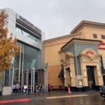
Central to the redevelopment is the mall itself, which is owned by Macerich, a publicly traded real estate investment company. Macerich seems poised to redefine what a shopping mall is, and their plan includes an “activated community plaza, 24/7 energy from hotel guests and residences, and unique entertainment.” This re-orienting away from big box stores and toward a smaller, more urban-feeling retail experience has been dubbed “experiential” retail. Tigard is betting that this good ol’ real estate buzz will create the synergy they need to attract other residential and commercial developers to the area. Along with zoning changes and transportation improvements, they hope the concentration of activity at the mall site will support development throughout the regional center.
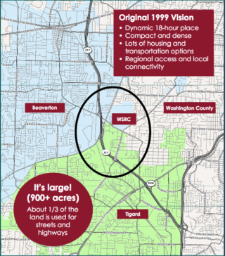
The SWRC is one of eight regional centers designated by Metro in its regional growth plan. It spans three different jurisdictions—the Cities of Tigard, Beaverton and unincorporated Washington county—and from the Washington Square mall it reaches out about a mile each direction to total 827 acres. The key land for redevelopment is in Tigard, and the shopping mall accounts for over a third of that area. Interestingly, roads also cover one third of the surface area.
The Draft Plan itself was very readable, and I appreciated that the documents were direct about discussing the challenges to realizing various aspects of the plan. In particular, the Executive Summary: Existing Conditions, Opportunities, and Needs was really informative. It was there I learned that most of the existing development in the WSRC was built before there were stormwater run-off regulations and that it doesn’t meet current stormwater standards. Redevelopment will trigger current stormwater requirements. The Non-vehicular Transportation Audit by consultants Toole Design was also an excellent run-down on the inadequate active transportation facilities in this auto-centric region.
Tigard’s Community Development Department recently released the Draft Final Report and it will go before their Planning Commission on November 15th and the City Council on December 14th for adoption of project recommendations.




Thanks for reading.
BikePortland has served this community with independent community journalism since 2005. We rely on subscriptions from readers like you to survive. Your financial support is vital in keeping this valuable resource alive and well.
Please subscribe today to strengthen and expand our work.
Susan Shanks, who is a senior planner with the City of Tigard, emailed me with responses to some of the questions brought up in the comments section. This what she said:
Uh. The plan needs a trail that goes through the Portland Parks-owned Red Tail Golf Course so that people can go from SW Oleson Road to SW Scholls Ferry Road. It would connect TriMet buses and they can even make it accessible to emergency vehicles. The authorities refuse to do that.
Redtail Golf Course is in Beaverton proper, does Portland Parks actually maintain it?
Redtail looks commercial: https://www.golfredtail.com/
As is the nearby Portland Golf Club: https://www.portlandgolfclub.com/
Red Tail is one of five golf courses owned and operated by Portland Parks:
https://www.portland.gov/parks/sports/golf
And here is Red Tail’s specific PP&R listing:
https://www.portland.gov/parks/redtail-golf-course
Would the priority be to have a long bike path along the periphery of the course? Or to use the existing golf cart paths within the course?
It looks like there’s already a paved maintenance driveway along the east boundary of the golf course north of Oleson Road, complete with a pedestrian island and bike lanes. https://www.google.com/maps/@45.4551323,-122.7708984,3a,75y,90t/data=!3m7!1e1!3m5!1stGIMw4IUTbbFnXT_xRQoDg!2e0!6shttps:%2F%2Fstreetviewpixels-pa.googleapis.com%2Fv1%2Fthumbnail%3Fpanoid%3DtGIMw4IUTbbFnXT_xRQoDg%26cb_client%3Dmaps_sv.tactile.gps%26w%3D203%26h%3D100%26yaw%3D54.876106%26pitch%3D0%26thumbfov%3D100!7i16384!8i8192
There’s also “street view” images within the course, on the greens, taken by someone wearing a white bike helmet.
There is no trail for public use on that golf course unlike that other city-owned course in East Portland.
Amanda Fritz, a former Portland city council member, told me about the Portland Parks ownership via email when she was on city council and used her city email to say that. She said there weren’t plans to build that trail. Perhaps the Portland Parks Foundation needs to know of the need for that trail.
And given the fact that we’ve had to dump millions of public money into the PP&R golf fund in recent years, they can’t really argue that the courses shouldn’t have more public access. These are our parks.
Raleigh Hills on Scholls Ferry at Olesen is a Dangerous Intersection, it needs to be moved next to a Former Safeway. A new Curves on Olesen Road will make room for more line up Traffic Lanes. Including New Traffic Signals. Maybe Build Bridges on Scholls Ferry over Beaverton Hillsdale Highway cause the Light is Very Long. That is a Crazy Intersection that could take up to 30 Minutes or Longer. Which it isn’t good at all. That causes Road Rage. They would be Late to Work or Appointments.
Thanks for you coverage, Lisa! This is nice to learn about. I live in South Burlingame but bike out through this area quite often for work and the gym (less so during the pandemic but still regularly). I’m having more than a few chuckles over some of these areas they’ve labeled “Quiet Connecting Neighborhood Streets.” There’s no way that Allen, Oleson, or Denny are “quiet”, or “neighborhood streets” by any stretch of the imagination. I hope Metro and Beaverton are looking into that section! But this area around the mall desperately needs pedestrian and bike improvements so I’m glad Tigard and Metro are at least thinking about it.
People still go to malls? Haven’t been to one in years.
Yes, they do.
I was at Washington Square last weekend and was surprised how busy it was.
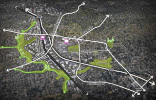
There are two bicycle stores within the oval ring in the last photo. There are empty buildings in Washington Square, a compact transit center with a half-foot pothole, and empty car parking lots during shopping season but as lot of potential for better planning in those neighborhoods.
That’s cool. Like to check that out with my kids. I don’t feel safe riding with them in most of Portland anymore. Too many crazies!
Talk about bike friendly? A bit off the subject, but I got a kick out of a full-page color ad in one of those upscale travel mags titled Bicycle Vietnam. Yup, for real. You can now bike the Ho Chi Minh trail, visit the notorious Hanoi Hilton prison, visit famous battle fields, etc., all in luxury.
One wonders if the Taliban will pick up on this?
This needs too be passed over too the Lloyd center Malls new Owners be for an final dission making .And its not the dission they will regret.
“experiential” retail– I guess “urban village” wasn’t new and sexy enough but still it’s cool that Macerich is moving to put that theory into practice.Thanks for posting this. The project is much needed. One of the most important things about this plan is not the bike stuff but that a suburban government is saying that it’s time to move to higher densities.
Thank you for making that point, I totally agree. I didn’t try to address that, but it’s significant and it got me pulling up census maps and looking at densities and topography.
Unfortunately until plans like this starting including the removal of auto lanes anyone with a choice will still avoid these areas. But regardless these are some critically neglected areas.
I’d like to see this plan address the lack of bike lanes on the Hall Ave bridge over 217. That’s right next to the mall, but is a major gap in the bike network in the area.
Similarly, I think the speed limit on Hall should be lowered. It’s far too fast around the mall, given all the intersections and driveways coming out of the mall.
217 widening builds bike lanes but they’re not protected on both Hall overcrossings.
If that’s true, that’s great. The last time I saw the plan it only addressed the other cross of of Hall and 217 further south.
see pinned post at top re 217 and Hall
This is fantastic! So Metro has ID’d 8 areas to make into villages (regional centers)? The housing story here is enormous! With the shift in retail, online shopping this is a win win. Put citizens in the parking lots, business needs shift and support local residents. The transit needs noted here are great, but if the village succeeds then all sorts of changes to mobility will be desired and more readily realized. I think this is a great example for us Bike folk that it’s not about the type of vehicle exactly, it’s the infrastructure within which vehicles will function that dictates purpose. Love, love love to see this thinking. Hopefully it is wildly successful.
We should plan a Major Makeover Construction at Washington Square Mall, it needs to expand 2 Floor Stories all the way to All Department Stores & Food Court Connections. Including New Escalators & Elevators. So that way they can fit in more new store spaces. In order not to shut down any stores or make it dead as Lloyd Center Mall. Trimet Bus Shelter should get relocated by the Food Court as well. Parking lots and Outside of a Mall needs to be Repaved cause it’s terrible with lots of cracks. Also to install a New Elevator at Parking Garage outside of Macy’s. Inside Macy’s that Elevator Door Outside needs to be replaced cause there is Graffiti on it.
If Federal Government gets approval to do Grade Separation Project on Elimination to Railroad Crossings on Scholls Ferry Road & Hall Blvd at 217 Ramps. Both of them to get reconstructed to an Overpass Someday. Cause it’s a Major Street & we want to Save Life’s without getting hit by a Train wether it’s Trimet WES or Portland & Western Freight Trains that share a track needs to be partially a Double Tracks. Which will mean 2 Bridges over Highway 217 will get fully rebuild so it goes over the Train Tracks.
We do wish that Highway 217 will have 4 Travel Lanes in each direction with a Tolling Lanes.